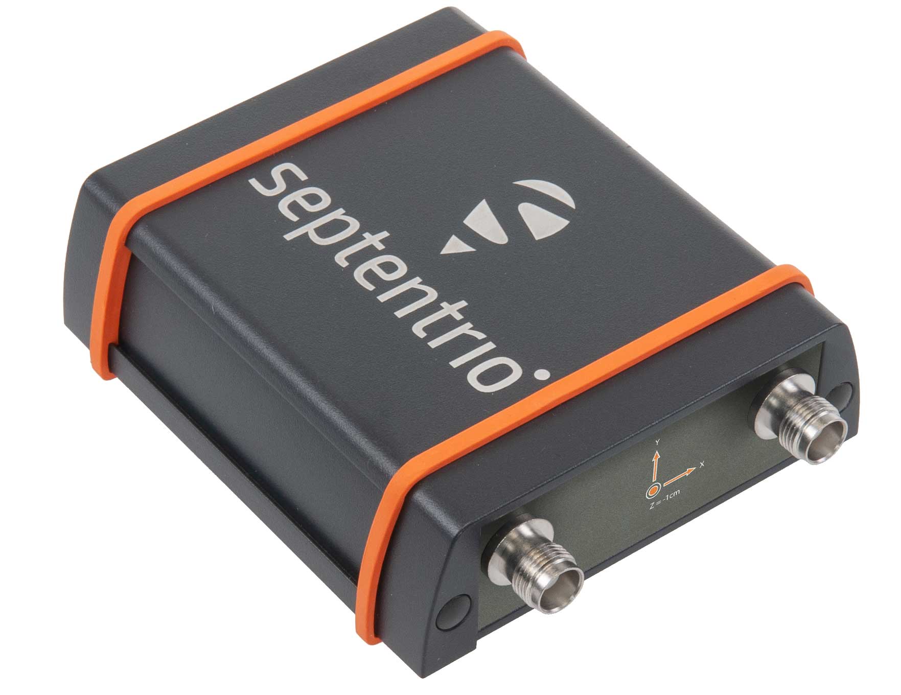
The AsteRX-SBi has a rugged housing, making it suitable for machine control and other outdoor uses. (Photo: Septentrio)
Septentrio has expanded its GNSS/INS portfolio with the AsteRx SBi, a new housed GNSS/INS receiver. The ruggedized AsteRx SBi fuses high-accuracy GPS/GNSS with a high-performance inertial sensor to provide reliable positioning and 3D orientation for machine control and logistic applications.
Within its rugged, waterproof enclosure, a high-performance GPS/GNSS is coupled with an industrial-grade inertial sensor to provide high-accuracy, reliable positioning and 3D orientation (heading, pitch, roll).
Offering the flexibility of either single or dual antenna, AsteRx SBi is designed for quick and easy integration into any machine monitoring or control system. AsteRx SBi packs performance and durability into a single, compact box. Reliable location and 3D orientation data is streamed with a high update rate and constant low latency.
“AsteRx SBi was designed with ease of integration and reliability in mind. Its compact, ruggedized housing is optimized for easy clamping to any machinery,” said Danilo Sabbatini, product manager at Septentrio. “It has all the features and tools needed for straightforward integration into machines or large robotic systems.”
Septentrio reliable centimeter-level positioning is based on true multi-frequency, multi-constellation GNSS (GPS, GLONASS, Galileo, BeiDou, QZSS) technology. AsteRx SBi combines GPS/GNSS and an industry-grade IMU (inertial measurement unit) to deliver precise positioning together with 3D attitude.
The AsteRx SBi is a robust positioning solution for machinery operating in environments challenging for GNSS. (Photo: Septentrio)
Septentrio’s unique GNSS–IMU integration algorithm enables continuous positioning in environments of low satellite visibility where short GNSS outages are possible. This is referred to as coasting or dead reckoning, and can happen near high structures, under bridges or under thick foliage. This makes AsteRx SBi a robust positioning solution for machinery operating in environments challenging for GNSS, such as in container yards, urban canyons or near cliffs.
AsteRx SBi comes with built-in Advanced Interference Mitigation (AIM+) technology. In busy urban environments electromagnetic waves can interfere with GPS and GNSS signals. AIM+ offers protection against such interference resulting in faster set-up times and robust continuous operation. A built-in power spectrum plot allows users to analyze interference, helping locate its source and mitigating it.
“Seen & Heard” is a monthly feature of GPS World magazine, traveling the world to capture interesting and unusual news stories involving the GNSS/PNT industry.
Batman only wishes he had one
New miniature GPS “backpacks” are making it possible to track tiny desert bats, providing insight into their lives. Tiny 1-g GPS tags showed University of Helsinki researchers that Africa’s yellow-winged bats struggle during dry periods. The species is one of the few desert bats large enough to carry the tag. Researchers placed GPS trackers on 29 bats, 15 in the rainy season and 14 in the dry season, for one week each, and recorded their positions every 30 to 60 minutes each night.
Photo: iStock/ MBPROJEKT_Maciej_Bledowski
The wheels on the bus need GPS
All New York City public school buses will provide GPS tracking by the first day of class this fall. The city has teamed up with Via to install the equipment and provide an app for real-time tracking of the nearly 10,000 buses. The city council approved the tracking program after a sudden snowstorm in November 2018 left buses stranded in traffic for hours, and parents couldn’t reach their kids.
Keep on truckin’
Shipping company UPS is investing in autonomous deliveries, specifically in TuSimple, a robot-trucking startup. UPS is testing self-driving tractor trailers on a route between Phoenix and Tucson, Arizona, to help it understand requirements for Level 4 autonomous trucking. TuSimple completed a two-week pilot with the U.S. Postal Service in May, hauling mail between Phoenix and Dallas. All TuSimple trucks operate with two technicians in the cab, with the aim to operate without drivers within two years.
A+ for GPS Cows
High-school students interested in agricultural professions can now learn about the use of GPS for monitoring livestock, and even make their own GPS collars. The collaborative GPS Cows program brings together industry researchers, professionals and educators from the U.S. and Australia. GPS Cows is fighting the misperception that ag-focused students don’t need digital literacy, and is engaging them in agri-tech, specifically tools and systems that provide animal location and behavior data.
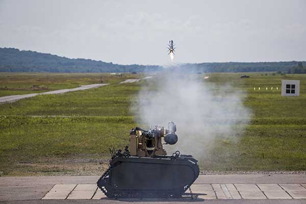
Remotely controlled Javelin firings can help keep soldiers out of harm’s way. (Photo: Lockheed Martin)
The Javelin Joint Venture team, a partnership of Raytheon Company and Lockheed Martin, successfully fired Javelin missiles from a Kongsberg remote launcher mounted on a Titan unmanned ground vehicle built by QinetiQ North America and Milrem Robotics.
The demonstrations, conducted at the U.S. Army Redstone Test Center, Alabama, validated the integration of the weapon station, missile and vehicle.
“Javelin is ready to support emerging military robotic vehicle requirements,” said Sam Deneke, Raytheon Land Warfare Systems vice president. “Remotely operated technology like this protects soldiers in battle.”
Javelin has been fielded on the Common Remote Operations Weapon Station-Javelin across U.S. Army Stryker 8×8 vehicle brigades in Europe.
“Javelin offers true fire-and-forget engagements to 4 kilometers in most operational conditions,” said David Pantano, Javelin Joint Venture vice president and Lockheed Martin Javelin program director. “Once the launch command is issued, soldiers and vehicle assets like the UGV can reposition out of harm’s way. These tests demonstrated our ability to evolve Javelin capabilities to address new missions in support of the warfighter.”
Javelin is a versatile one-man-portable and platform-employed anti-tank and multi-target precision weapon system. The Javelin Joint Venture team has produced more than 45,000 Javelin missiles and 12,000 command launch units. The program continually updates the system to stay ahead of advancing threats, including enhancing its platform-mounted capabilities.
U.S. and coalition forces have used Javelin extensively in Afghanistan and Iraq in more than 5,000 engagements.
A sonar survey, camera and sensor data of the world’s largest marine sinkhole is shining light on sea level and climate change over 100,000 years.
From Nov. 27 to Dec. 13, 2018, the Blue Hole Belize Expedition mapped the sinkhole. Led by Aquatica Submarines, the team of scientists, explorers and film makers included Virgin ’s Sir Richard Branson and Fabien Cousteau, grandson of the conservationist Jacques Cousteau.
Kongsberg used both surface and submarine-mounted sonar equipment.
Sonar expert Mark Atherton from Kongsberg’s Canadian subsidiary Kongsberg Mesotech was a key member of the science-based sonar and scientific data collection team. Atherton operated the sonars aboard the Research Vessel Brooks McCall, contributing to an invaluable high-resolution map of the entire sinkhole.
“By understanding the geological history and geometric structure at the Blue Hole we can contribute new data to the global scientific community studying sinkholes and cenotes,” he said.
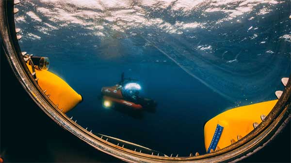
Photo: Aquatica Submarines
Aquatica Submarine’s Stingray 500 submarine was used for sonar surveying, filming and dives. The team conducted more than 20 dives into the large sinkhole, taking videos and 3D images during each trip. They also completed a two-hour live broadcast featured on The Discovery Channel.
A key outcome of the Expedition is creation of a complete 3D sonar map of the Blue Hole. The sonar map is enhanced with other passive submarine-collected environmental data. Once processed and collated, the data will be shared with the Government of Belize and the larger global scientific community as a legacy from the expedition.
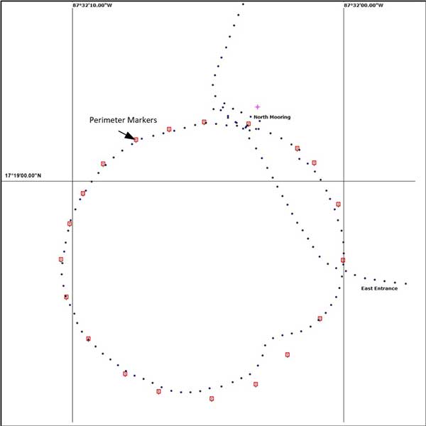
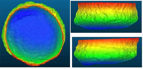
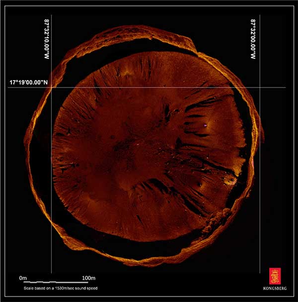
Perimeter Markers: Using an SBG Systems Ellipse receiver positioned directly over suspended tripods, positions were locked in the MS1000 processing software the instant each tripod touched bottom. With no current within the Blue Hole and the tripod and sonar weighing 21.7 kg, there was no issue with offset position differences between the vessel and the tripod hanging plumb during deployment. (Image: Mark Atherton/Kongsburg)Processed Scan Data: A dual-axis sonar (DAS) system collected point-cloud data to create a 3D representation of the Blue Hole. The unit was pole-mounted on the survey vessel with the GPS and motion reference unit directly over the scanner’s head. (Image: Mark Atherton/Kongsburg)Mosaic: GPS tripod position and target matching on overlapping scans were used to align the 50-, 75- and 100-meter-range data collected at 21 drop locations. This mosaic is a very close approximation of the bottom of the Blue Hole. (Image: Mark Atherton/Kongsburg)
Mothers Against Drunk Driving (MADD) has partnered with Velodyne Lidar, a provider of real-time 3D perception systems for a range of commercial applications, including autonomous vehicles. The initiative includes a website on the safety benefits of autonomous vehicle technology (see velodynelidar.com/madd-partnership.html) and an October conference on autonomous safety.
“We have learned that technology is essential to getting us to our goal of zero deaths caused by drunk driving,” said MADD President Helen Witty. “Autonomous vehicle technology holds the incredible promise of helping us eliminate drunk driving.”
The summit is designed to advance understanding of the safety benefits that can be achieved with autonomous vehicle technology. It is designed for business, government, public safety and community leaders. Attendees will have the opportunity to ride in autonomous vehicles.
Marta Hall, Velodyne Lidar’s president and chief business development officer, added, “Our goal is to design, develop and mass-produce lower cost lidar sold for every model of car and truck.”
The two organizations partnered in 2018 to create the website with information on how autonomous vehicles can help prevent roadway collisions. The site explains the basics of autonomous driving in easy-to-understand language for all audiences. Content modules include “Lidar 101,” explaining how lidar sensor technology is an essential component of self-driving vehicles.
A 3D lidar sensor such as the Velodyne Alpha Puck can deliver information to help enable vehicle autonomy and advanced driver-assistance systems. (Image: Velodyne)
“The promise of safe, self-driving cars is very exciting, particularly for those of us who have seen the devastation that impaired driving and human error can bring,” said former MADD President Colleen Sheehey-Church.
Puck Sensor. The Velodyne Alpha Puck is a lidar sensor specifically made for autonomous driving and advanced vehicle safety at highway speeds. In a session at July’s Automated Vehicle Symposium, company speakers presented “High-Definition 3D Lidars: An Integral Part of Future Autonomous Driving,” including use cases that have proven elusive for solutions based on camera and radar; and “State of Solid-State 3D Lidar,” a technical presentation on application-specific integrated circuits (ASICs).
“Core lidar electronics are moving from a printed circuit board to an ASIC, which provides advantages such as higher density, lower cost and improved reliability,” said UAV and Robotics Business Manager Frank Bertini. “The trend roughly follows Moore’s Law, leading to dramatic decreases in size, weight and cost over relatively short time periods.”
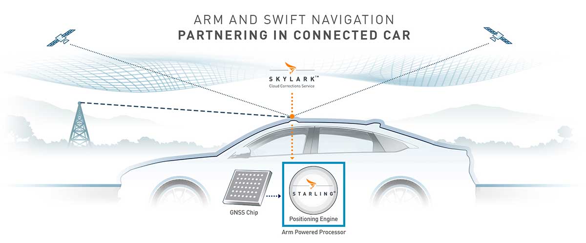
The Swift/Arm partnership means Arm will offer Swift Navigation’s high-integrity, high-accuracy GNSS positioning solutions as an option on Arm-based platforms to developers of autonomous and connected vehicles. (Image: Swift Navigation)
Swift Navigation is partnering with Arm, a global leader in semiconductor IP.
The partnership means Arm will offer Swift Navigation’s high-integrity, high-accuracy GNSS positioning solutions as an option on Arm-based platforms to developers of autonomous and connected vehicles.
Swift Navigation is a San Francisco-based tech firm redefining GNSS positioning technology for autonomous vehicles.
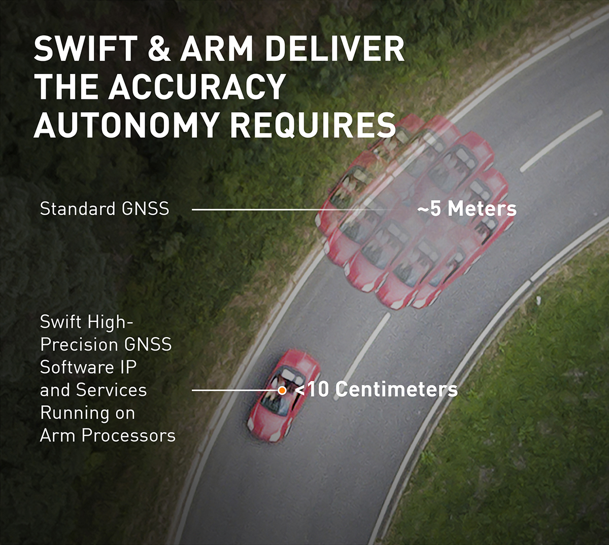
Standard GNSS positioning is three to five meters in depth which is not suitable for safety-critical systems requiring lane-level accuracy. For higher levels of autonomous capability, a vehicle needs to be able to determine its absolute location. To achieve this, high-precision localization is needed to get to accuracy down to the centimeter.
Swift’s partnership with Arm will deliver a high-integrity, high-accuracy GNSS positioning solution for silicon makers and Tier 1 and 2 auto suppliers to integrate precise positioning into the sensor suite.
Swift Navigation’s Starling is a GNSS positioning engine designed for just such automotive and autonomous vehicle applications. Starling’s software enhances the measurements for commercially available GNSS receivers to provide true precision and integrity capabilities. Starling is receiver-agnostic, so it is ideal for Arm customers as it works with a variety of automotive grade chipsets and inertial sensors.
Swift’s partnership with Arm will deliver a high-integrity, high-accuracy GNSS positioning solution for silicon makers and Tier 1 and 2 auto suppliers to integrate precise positioning into the sensor suite. (Image: Swift Navigation)
Swift and Arm are working together to provide developers of autonomous and connected vehicles a cost-effective, scalable and high-integrity positioning solution. Starling is designed to be compatible with industry leading silicon makers who build their solutions on Arm.
Starling works with a variety of GNSS measurements engines and is a hardware proven, end-to-end solution, tunable for the specific requirements of a customer’s platform. This partnership elevates the capabilities of the connected car and simplifies the integration of high-precision GNSS into Tier 1 and 2, Silicon and Platform and Automotive OEM vendors.
“We are pleased to join the ecosystem of Arm technology partners to deliver precise positioning solutions to its automotive and autonomous vehicle customers,” said Timothy Harris, chief executive officer of Swift Navigation. “This partnership opens up a broader audience of customers who can benefit from Swift’s positioning technology and builds on our mission to enable a future of autonomous vehicles.”
“As we strive toward an autonomous future, the requirements of the automotive market are changing, and a more solution-based approach is needed,” said Dipti Vachani, senior vice president and general Manager, automotive and IoT line of business, Arm. “The combination of Arm IP uniquely designed for automotive and Swift’s GNSS solution gives our partners another key component on the road to the effective deployment of autonomous vehicles at scale.”
Available for purchase today for Arm-based processors, the Starling positioning engine provides a rapid deployment, low total cost of ownership solution to enable widespread adoption of ADAS, connected car, C-V2X and autonomous solutions.
Interested parties should visit this website to get more information on using the Starling positioning engine on Arm-based devices.
The joint solution will be also be showcased at the IAA New Mobility World 2019 event from Sept. 10-15 at the Arm booth, Hall 5.0, stand A10, Frankfurt Messegelände.
GMV has been awarded a contract for development of a precise GNSS positioning system with integrity for the new generation of autonomous vehicles of the German carmaker BMW Group.
The Spanish multi-national’s technology solution is going to be developed for the first time in BMW Group’s autonomous vehicles. GMV’s positioning software calculates the vehicle’s position and other magnitudes, using advanced GMV-developed algorithms, including components that have already been patented. These algorithms have been especially modified and adapted to meet BMW Group’s performance and safety requirements.
Photo: BMW Group
The developed software will abide by the most demanding automotive standards and the highest quality levels of safety-critical software, GMV said.
Another key component provided by GMV is a GNSS correction service to be run in a secure infrastructure using data from a global network of monitoring stations to be set up by GMV under this contract.
This new project cements GMV’s position as a supplier of GNSS-based autonomous-car positioning solutions, the company said.
“GMV has been investing for many years in the key GNSS technologies that are essential for autonomous driving systems,” said Miguel Ángel Martínez Olagüe, GMV’s general manager of Intelligent Transportation Systems. “For our company this contract represents a unique opportunity to capitalize on all that effort, providing a product of outstanding performance for the automotive industry.”
Spectra Geospatial has introduced the MobileMapper 60, a durable, efficient and accurate handheld device for geographic information system (GIS) and professional data-collection applications.
The MobileMapper 60 all-in-one GNSS receiver and smartphone combines a convenient form factor for geospatial data collection with 2-4 meter positioning accuracy. Its slim, lightweight all-weather design, complete with a hand strap, features a large 6-inch screen with high resolution for easy viewing and data manipulation.
With a large capacity all-day battery and rugged exterior, the MobileMapper 60 will operate continuously in range of extreme temperature and environmental field conditions.
Running an Android 8.0 operating system, it has a fast 2.2 GHz processor, 4 GB of memory and 64 GB of storage for managing large data sets with ease and speed. Bluetooth 4.1, 4G LTE and Wi-Fi capable, the MobileMapper 60 is ideal for a wide range of jobs, including cadastral, survey, topographic, forestry, control and much more.
“The MobileMapper 60 gives GIS and survey professionals a rugged, easy-to-use, smartphone device for data collection in the field,” said Olivier Casabianca, general manager, Spectra Geospatial. ”The MobileMapper 60 is a powerful solution for field professionals , making it easier than ever to work efficiently in the field.”
TerraFlex users can now synchronize data directly to their on-premise Esri geographic information system without cloud services.
Photo: Trimble
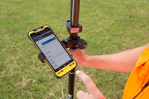
The new software workflow — called offline data transfer — is possible through the integration of Trimble TerraFlex and the Trimble Positions Desktop add-in for Esri ArcGIS Desktop.
TerraFlex is a field solution that enables mobile workers to easily collect, manage and edit their geospatial feature data.
The new workflow provides an alternative to using Trimble cloud services for storing and transferring GIS feature data collected with the TerraFlex platform. In addition, TerraFlex field data collected via this workflow using a Trimble GNSS receiver can be post-processed directly inside the Trimble Positions Desktop add-in for improved positional accuracy.
“With this new feature, TerraFlex fulfills the need of organizations such as government agencies and utility providers who cannot keep their data in the cloud because of regulatory constraints or business rules,” said Rachel Blair-Winker, business area manager for Trimble Mapping & GIS solutions.
“By introducing the new workflow to our TerraFlex software platform, customers who prefer direct desktop methods of transferring data between field and office (such as USB) and need post-processing capabilities can now benefit using this new solution without having to change their current business practices,” Blair-Winker said.
Trimble TerraFlex is available online or through Trimble’s Authorized Geospatial distribution channel. The mobile apps are available in Apple’s App Store and the Google Play store.
The Trimble Positions Desktop add-in is available through the Trimble Geospatial distribution channel. The new workflow functionality will require the latest version of both applications.
With the calendar pages turning rapidly and as we get closer to the witching hour of geospatial voodoo, more items have surfaced to discuss and educate ourselves on in relation to “the change.”
Let’s delve into these topics and break each down into what the common surveying and geospatial practitioner will need to know with the advancements in coordinates, geodesy and our everyday uses.
NATRF2022: The continental U.S. replacement for NAD83 and NAVD88
It is no secret that with the advancing use of GNSS technology, flaws in both existing horizontal and vertical datums establishing our National Spatial Reference System (NSRS) have been identified and exposed.
NGS estimates that NAD83 is non-geocentric by over two meters, while the model establishing NAVD88 contains a tilt of approximately one meter across our continent.
For most geospatial practitioners, these flaws are minimal to the integrity of their data. It does, however, give us a glimpse of how assumptions of geodetic information can produce incorrect modeling of surveying and mapping data and could lead to more flawed earth models without significant changes to their structure.
With a great number of surveying and mapping practitioners using GNSS technology with little or no knowledge of the origins of our NSRS, it is a good time to provide the primers below to explain the history of our geodetic datums.
Besides my previous article, follow these links for much more thorough technical information:
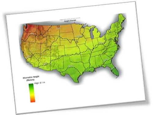
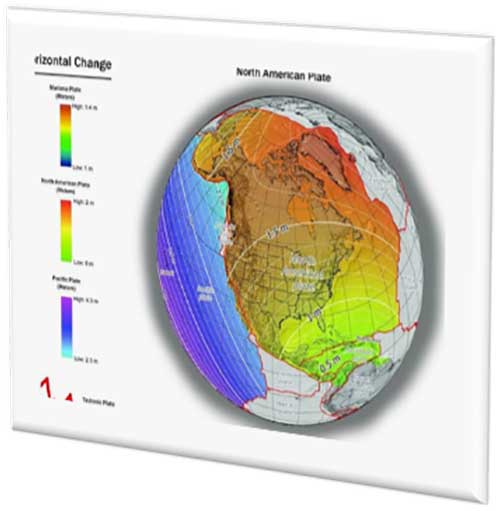
With changes in both horizontal and vertical datums, slight variations in the data we are used to seeing will seem insignificant, but will require the user to pay close attention to potential data traps when converting between the old and new systems. The NGS graphics below depict the severity of datum change in the horizontal and vertical component across the U.S.
Image: NGS
Depending on where you are working, new state plane coordinates will vary from –2 meters to +4.5 meters from previously published values, with elevations fluctuating up to one meter from previous norms. All these changes are due to the increased knowledge of our world using various forms of emerging technology not thought possible several decades ago.
These new measuring methods and studies, including GNSS and gravity monitoring, have allowed scientists and geodesy experts to establish more accurate geographic location systems than past terrestrial ways and procedures.
We have geodetic monuments and marks everywhere; will they still be usable?
The short answer to this question is an unequivocal yes, but with some caveats. Use of GNSS monitoring has proven we reside on tectonic plates that move slowly over time; thus, the geographic values (latitude and longitude) used to calculate any number of coordinate value systems are changing as well.
Image: NGS
Relational data between established points are not likely to change, but studies have shown significant shifts in areas that result in movement of our previously considered “unmovable” monuments.
With additional parameters and characteristics being introduced with the 2022 datum, time and tectonic plate shift are main factors in establishment of a point.
The concept of a “permanent” point no longer exists in relation to a published and unchangeable coordinate value of horizontal and vertical data. The surveying and geospatial data collector must recognize that the user is establishing a particular X/Y/Z or N/E/Z value for that exact moment in time and it, theoretically, will change from the moment one steps away from the point.
This may be too “splitting of hairs” for most users, but the new system simply recognizes the reality of the moving data-collection stage, no matter how minute.
This datum re-establishment has been a monumental undertaking (no pun intended), and NGS deserves many kudos for coming up with a realistic solution for a complex problem.
However, most of its users still have a problem, and it lies within the standard unit of measurement: the U.S. survey foot. NGS (and its predecessor, U.S. Coastal and Geodetic Survey) have always used the meter for the basis of all units of measurement (as does the rest of the world.) The new 2022 datum is bringing us, the surveyors and mappers, to a new reality — nationwide adoption of the international foot. Let the grumbling and arguments begin!
The meter vs. international foot vs. US survey foot
The unit of measurement aptly named the “foot” has existed since early times, with most sources crediting King Henry I of England making a decree that his foot shall become the standard for measurement.
No matter where the definition of the foot came from, it has varied slightly throughout history. The origin of the meter (or metre, as it’s known worldwide) also has a variety of beginnings. The most established story starts from John Wilkins, an English philosopher, who published in 1668 what he described as a new standard of measurement based upon the length of a pendulum that swings approximately 38 inches across in one second. This length was eventually named the meter by an Italian scientist.
Another century later, King Louis XVI of France issued a integration law establishing the modern metric system with weights and measures having a base-ten system of units and sub-units. Within this system was the meter with a new length definition of being one ten millionth (1/10,000,000) of the distance from the North Pole to the Equator.
Upon completion of the calculations, a rectangular bar made of platinum and iridium was created to establish the “standard” meter from which all future measurements would be based.
The United States first recognized in 1866 the metric system and the meter (set forth as one meter equaling 39.37 inches). During this time, the International Commission of the Meter officially adopted the physical meter bar as the standard.
Over the next 100+ years, many studies were undertaken to re-establish the length of the meter. Using wavelengths of various elements, including cadmium, mercury, neon, zinc, helium, thallium and krypton, new definitions were created. In 1983, the current definition of the length of the meter was finalized.
The meter is now based upon the speed of light in a vacuum (299,792,458 m/s) with the meter being the length traveled in 1/299,793,458 of a second. While the length is very close to the original measurements set forth over the centuries, it is better defined for reproduction worldwide without having to possess a standard bar or other device.
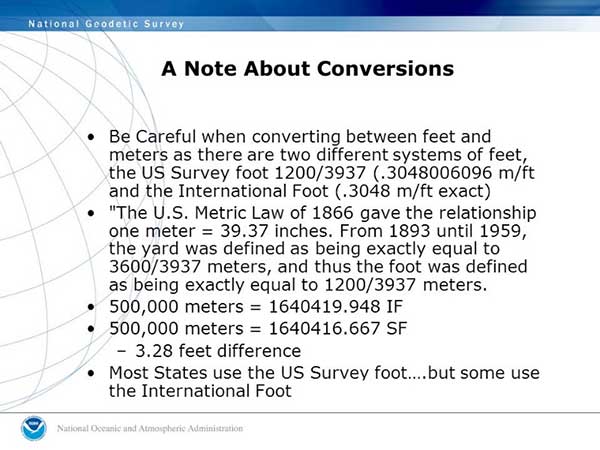
To further muddy the standardization of units, in 1959 an international agreement was made by Australia, Canada, New Zealand, South Africa and the United Kingdom so one yard would equal 0.9144 meters. Meanwhile, the U.S. National Bureau of Standards published a notice that all survey-related measurements will remain based so one one yard equals 3600/3937 meters or 0.91441083 meters.
Image: NGS
We have two different measurements for the foot. What’s the big deal?
The difference between the two standards is two parts in one million; while that doesn’t affect everyday physical measurement, it does cause havoc on coordinate systems with values beyond the millions. (See NGS video “Two Right Feet?” for details).
What makes it even more confusing is that states across our country vary on which “foot” is standard within their legislation and daily practice. Currently (at the date of publication), six states recognize the International Foot as their standard unit of measurement, with four states not defining it. The remaining states have officially adopted the U.S. survey foot as their standard unit of measurement.
NGS has suggested that starting with the 2022 datum change, the U.S. survey foot will not be supported in applications and software produced by them for geodetic computations. It will be limited to meters and the international foot, so they are recommending that states update their existing definitions to change to the international foot along with recognizing the 2022 datum as the official coordinate-system base.
How to train our profession, the construction industry and John Q. Public on the new datum
I would be lying to you if I said I’m not concerned with the rollout of the new datum and with converting all surveying and mapping work to the international foot. My biggest concern is not with those direct relationships I have with my staff and fellow professionals within my company.
My main concern starts with these two areas: the tens of thousands of surveying practitioners working within projects containing state-plane coordinate systems in addition to contractors and other mapmaking providers using survey-grade equipment for construction and other mapping applications.
Both groups have little to no technical knowledge of the intricacies of state-plane coordinate systems and the geodesy network “behind the curtain.” To paraphrase a well-known mortgage company with an app-based home loan system, “push button, get data” is the limit of most users’ knowledge when it comes to state-plane coordinates.
Add to this the double-edged sword of real-time networks, where the user does not have to be concerned with setting up a base station, and the potential problems could get worse.
While there will be a few early and timely embracers of the new datum, the majority will dig their heels in and refuse to switch. When the conversion to the 2022 datum is upon us, many users will drag their feet on learning about the new system as existing projects continue under the old datums.
Until there is a mandate by government agencies and others, many newer projects beginning around the adopting time will remain on NAD83 and NAVD88 until directed otherwise.
Most practitioners I have spoken with on this issue agree that it will be a tricky period for surveying and mapping. Rather than get bogged down with negativity and fight change, the surveying, mapping and geospatial community should do the following:
Rally our professions around these significant changes to educate our technicians and future professionals.
Coach contractors and other trades who rely on the technology to understand the new system.
Work with governmental agencies at all levels to educate them about what these changes entail and why to make the appropriate revisions to codes and statutes now.
Capitalize on this opportunity to teach the public about who we are and how spatial data is part of everyone’s life.
All these points are paramount to the success of the datum upgrade and need to be followed through to the end. Ultimately, the faster we adopt and adapt, the better our geospatial world will be. There is lots of work ahead of us, but as the staff at NGS has shown us, the hard work necessary to make significant change is well worth the effort.
CALLING ALL SURVEYORS AND GEOSPATIAL PROVIDERS!
NGS announces GVX data format for GNSS vector processing
The National Geodetic Survey (NGS) is requesting input and feedback on a new data format for sharing real-time kinematic (RTK) GNSS vector information.
The new format will be like the static GNSS standard, Receiver Independent Exchange (RINEX), and is utilized by most software packages and the Online Positioning User System (OPUS).
The new GNSS Vector Exchange format (GVX), will introduce a new industry standard for sharing of RTK vectors across differing platforms and software packages.
Earlier users of GPS-based data collection remember the number of proprietary files created by each manufacturer, and having their own unique format for data and attribute interpretation. In response, the NGS created RINEX to help standardize data collection as a universal file format that would easily be adopted by receiver and software producers.
That same goal is being set with the introduction of the GVX format as the next step in data-collection standardization for GNSS RTK vectors. GVX elements include (but are not limited to) the following:
A-priori coordinates for the end points of each vector
Receiver and antenna types
RTK and real-time network (RTN) settings, if applicable
Quality control metadata (e.g., PDOP, number of satellites used, orbit type, etc.)
The introduction to the new format along with technical specifications and examples are on the NGS website.
The National Society of Professional Surveyors (NSPS) works directly with NGS to provide input on maintaining and updating the National Spatial Reference System and will include significant assistance with educating geospatial data providers with the upcoming 2022 datum change and implementation of the North American Terrestrial Reference Frame of 2022 (NATRF2022).
The surveying, mapping and geospatial professions have exciting times ahead with these cool upgrades from NGS, so we need to take advantage of the calm before the storm to educate ourselves to make the most of the opportunity.
Geospatial data surrounds all of us, and we are the profession specifically educated for correctly and efficiently keeping a handle on it all. It all starts with growing your knowledge a little bit each day. Please join me in growing the profession as well.
Ten projects in the MyGalileoApp competition have been named finalists.
Out of a shortlist of 30 semi-finalists, the 10 were judged to be the most exciting in terms of innovation, market potential and technical feasibility.
The 10 projects will now advance to the second development phase, at the end of which they should deliver a fully functioning app.
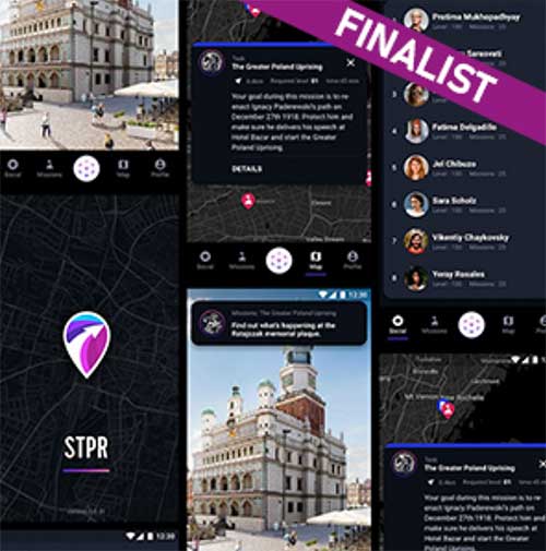
The STPR augmented reality app. (Screenshots: GSA)
Four of the 10 shortlisted projects are in the Augmented Reality and Games innovation area:
uMaze (Finland) — uMaze creates mazes in specific outdoor areas in which users can play.
ARGEO (Italy) — ARGEO allows users to discover content such as prizes, coupons and shopping cards geo-located around the streets of a city.
STPR (Poland, Australia, Ukraine) — The STPR app combines a virtual environment with game-related physical experiences in the real world.
arstory (Germany) — Arstory is a complete augmented reality ecosystem based on four main components: Galileo location, virtual objects in the real world, clustering of objects and a wide array of content options.
Apps in the smart navigation and infotainment innovation area include:
Ready Park (France) — Ready Park makes parking easier by pairing drivers leaving a spot with users looking for one.
Galileonaut (France) —Galileonaut helps sailors navigate inside a port or a marina and provides a link to the harbour master’s office.
Trukatu (Spain) — Trukatu is a mobile C2C platform that connects people who want to rent or lease items with owners who have items to rent.
Two of the shortlisted projects fall in the Fitness, Sport and mHealth category.
PanPan – Possible Assistance Needed (Germany) — PanPan serves as backup safety solution for potentially dangerous activities that may leave users in need of assistance.
LetMeAut (Italy) — LetMeAutmakes everyday tasks easier for people with autism.
One app is in the Mapping, GIS and Agriculture innovation area.
Tractor Navigator (France) — Tractor Navigator provides guidance for farmers driving tractors, enabling them to visualise their current position and trajectory in an open field.
The 10 projects have until Oct. 21 to deliver a finalized version of their app with 100% functionality. During this phase, the teams can receive technical support from the competition’s technical and business advisory team. At the end of the phase, the application should be already available for download on the Google Play and Apple platforms.
“The standard of entry in this year’s competition was very high, which made the judges’ task a difficult one. However, the final 10 projects stood out in terms of their innovative approach and uptake potential and we are looking forward to seeing the final working apps in October,” said Justyna Redelkiewicz Musial, in charge of LBS and IoT market development at the European GNSS Agency (GSA). “We hope that the 20 projects that didn’t make it into the second development phase will continue to develop their apps because, at the finals, they will also have the opportunity to demonstrate the progress that they have made,” she said.
All teams that will successfully complete the second development phase will be invited to the finals in November, where they will present their application to the GSA evaluation board.
The awards will be decided after these presentations, with the first-place winner receiving a EUR 100,000 prize. The runner up and third place winners will receive EUR 50,000 and EUR 30,000 respectively.
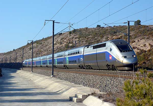
The French national rail company SNCF is adopting Galileo technology to boost customer services, in particular in its high-speed TGV network. TGV is France’s intercity high-speed rail service, and is operated by the SNCF.
With almost 50% of TGV trains already equipped with Galileo receivers, European GNSS is enabling improved customer information and traffic management.
Galileo is a technology building block that can precisely and safely locate trains and contribute to the future evolution of the European Rail Traffic Management System (ERTMS). ERTMS aims to harmonize signaling systems across Europe, and European GNSS can help reduce its costs.
SNCF is already embracing GNSS-based systems, in particular for passenger information, and fleet and traffic management.
“At the beginning of 2019, some 250 high-speed trains were already equipped with Galileo-ready receivers,” said Antoine Barre, head of SNCF train localization projects. “This represents nearly 50% of SNCF’s TGV fleet. Some 320 trains are expected to be Galileo-ready by the end of 2019.”
70 million passengers to benefit
The aim is to deliver Galileo-enabled services along the entire train journey and customer experience. During 2019, more than 70 million passengers will benefit from the improved accuracy and positioning availability delivered to French TGV trains by Galileo.
SNCF aims to equip its entire train fleet with Galileo receivers to assist non-safety relevant train localization. It also plans to further investigate the future contribution of European GNSS within ERTMS.
“Having Galileo on the iconic TGV trains is a major milestone for us, confirming that European GNSS is delivering a clear value added to one of the main EU Railway undertakings,” said Daniel Lopour, GSA market development officer.
“It is also good to see that SNCF is further progressing towards GNSS adoption on the regional fleet on the basis of the GSA position paper delivered earlier to the Community of European Railways (CER), explaining the benefits of Galileo for such applications,” Louper said.
Currently, signaling is enabled by equipment installed along rail tracks that requires regular inspection and maintenance. Accurate and reliable geolocation using GNSS will enable rail networks to reduce the cost related to the infrastructure.
Receivers installed in the train and connected via wireless networks should considerably reduce the costs of operation, maintenance and renewal of the network.
SNCF has identified three main themes of work for future rail technologies: geolocation, telecommunication and the use of satellite images for infrastructure monitoring.
Technology forward
Speaking at the Space for Innovation in Rail event, held in Vienna, Austria, March 18-19, Corinne Talotte described SNCF’s Technology Forward programme. Talotte is director of Innovative Technologies at SNCF. Talotte explain that the SNCF program is looking to build the “Railway for the Future” — a railway that is “autonomous, connected and zero emission.”
This spirit of innovation at SNCF aims to accelerate the implementation of new technologies. “First, this involves keeping an open mind on innovation and learning from other transport sectors,” Talotte said. “And our second important principle is to move to demonstrate innovative technologies as soon as possible in real operational situations to prepare the future deployment of innovations.”
Highly precise geolocation is a key element to enable autonomy in all modes of transport and future mobility systems. For trains, autonomous operation can increase the density of trains operating in the network while at the same time improving safety and reliability of customer services.
Space4Rail: From innovation to implementation
“We need to know accurately the position, velocity and attitude in real time to enable autonomous train systems,” explained Talotte. “We are developing a multi-sensor system for localisation based on GNSS but combined with other inertial sensors.
“This hybrid approach is inspired by the approach already adopted in the aviation sector. SNCF is undertaking a number of demonstrations with several partners, including the ERTMS user group and the Shift2Rail Joint Undertaking.”
Hybrid architecture
At the Space for Innovation in Rail event, Corinne Talotte said that SNCF was working on the remote operation of trains for use cases like shunting yards and the development of fully autonomous train prototypes.
The hybrid architecture makes it possible to take advantage of the benefits offered by both technologies: GNSS corrects the natural drift of the inertial unit, and when GNSS is not available, for example in tunnels or in dense urban environments, the inertial unit can take over to ensure continuity of location data. The inertial unit also protects the system from any possible disturbances in the GNSS signal, such as jamming or spoofing, as well as environmental factors.
The use of autonomous trains with innovative network control systems should enable SNCF to increase throughput on its lines. The objective is to carry more people and more goods, with greater regularity, improved energy efficiency and better economic performance, while ensuring continuing high levels of safety.
SNCF believes that the autonomous train is no longer science fiction, but the immediate future. A first prototype remote-controlled freight train should be tested some time this year, and the first prototypes of freight and passenger trains with autonomous driving capability are predicted beginning in 2023, with gradual implementation.