Check out a Nearmap high-resolution aerial image of Zions Bank Stadium/Real Academy. The solar was installed by Auric Solar. (Photo: Nearmap)
High-resolution aerial maps from NearMap are helping Auric Solar, a residential and commercial solar power provider, accelerate its initial site assessments, develop a more complete and accurate view of properties, and create winning proposals.
Auric accesses Nearmap imagery through the Aurora Solar platform, a solar sales and design software program. By utilizing Aurora software integrated with Nearmap imagery, Auric analysts have access to clear and current imagery. Headquartered in Salt Lake City, Utah, Auric services all of Utah, Idaho, Colorado and Oregon.
“Aurora’s responsive engineering interface coupled with Nearmap’s high-resolution captures allow us to use a combination of 3-D lidar models and 2-D high-resolution maps for complete accuracy in the planning and measuring stage of a project. This equips both the sales and analytics teams with accurate information to save time, money and serve the customer,” said Tyler Soukup, director of analytics at Auric Solar.
Analysts can make accurate measurements, run production numbers, identify roof obstructions and craft proposals all within the program. The sales team, analysts and installers are all on the same page, significantly reducing change orders.
The absolute horizontal accuracy of Nearmap’s georeferenced imagery is 0.75m (RMSE) or better. Measurements taken with Nearmap measurement tools are accurate to within 15cm for an individual photo. The company’s HyperCamera aerial photography system captures overlapping photographs along a flight path covering a survey area. Each photograph is tagged with its GPS location. Proprietary HyperVision technology then triangulates, orthorectifies and stitches these GPS-tagged photographs into a georeferenced photomap with an absolute horizontal accuracy of 0.75m (RMSE) and relative accuracy of 15cm. The process employs a combination of GPS positioning, high photo redundancy and triangulation of ground features to ensure this level of accuracy without the use of ground control points.
Solar panel installer Auric also has access to Nearmap historical imagery from years past, including leaf-on and leaf-off imagery, which presents the presence or lack of the foliage depending on the season. This greatly enhances shading analysis, making it easier to place the panels for maximum sun exposure. The company not only saves a significant amount of time with fewer onsite visits to qualify homes, but it also opens up more customers to solar.
“We’ve been able to qualify more customers than ever because of Nearmap’s clear, current captures. You really can’t accurately qualify a property without up-to-date imagery,” notes Soukup. “We quote projects from $20,000 to a few million dollars, and our proposals, plans and marketing materials should match that level of value. Nearmap helps us create a ‘wow’ factor.”
Before using Nearmap aerial imagery, Auric used using low-resolution satellite imagery to qualify properties. With outdated, blurry imagery, it was difficult to make accurate measurements and qualify a home before sending a technician for an on-site assessment.
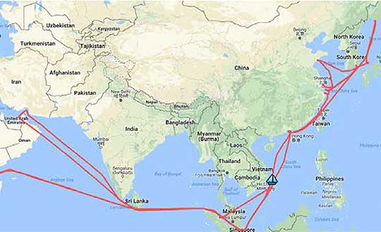
A year-long project aboard a commercial cargo ship collected tens of thousands of snapshots of radio-frequency interference in the GNSS band on a passage from Spain to Korea and back. Most interference was detected in busy port areas, less interference while transiting along coasts, and while least frequent, interference was still found in the open ocean.
Researchers at the German Aerospace Center (DLR) are still analyzing the vast amount of GNSS disruption data collected during the year-long project. Two papers have already been published about this project, and more are on the way, according to principle researcher Emilio Pérez Marcos.
In a paper presented at the Institute of Navigation last year, Marcos and his co-authors outlined the results of the last five months of this unique sampling experiment. Detection equipment was mounted on a large Hapag-Lloyd container ship. The antenna was mounted about 50 meters above the water line and provided a line-of-sight of 25km or more. The L1/E1 and L5/E5a frequency bands were continuously monitored. In addition to a “Snapshot” recording device used to save raw data samples (time snapshots), a more resilient DLR multi-antenna receiver was used to assess the impact of interferences in beamforming array GNSS receivers (semi-resilient).
As might be expected, the most interference was detected in busy port areas. Less interference was experienced while transiting along coasts. While it was the least frequent, interference was still detected during open ocean transits.
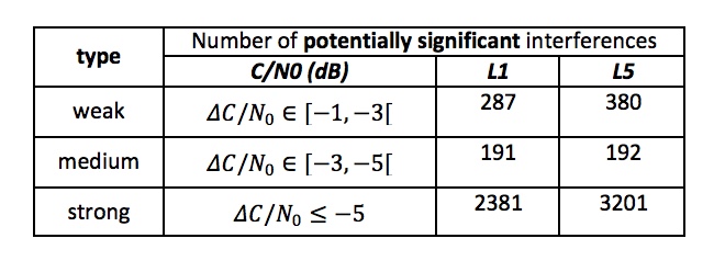
Table: Emilio Pérez Marcos and co-authors
Of the 39,045 snapshots recorded, 6,632 contained radio frequency interference at 1dB or higher. Separate tests have shown that many single antenna GNSS receivers begin to perform poorly with interference signals greater than 1dB. The other 32,413 snapshots could represent interference signals that may have come from weaker transmitters, sources more distant from the ship, been the result of adjacent band transmissions, or other phenomena.
Three particularly strong and persistent interference incidents were noted in the paper.
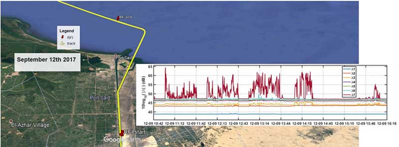
The first was detected when the vessel was transiting the Suez Canal northbound. The interference lasted around five hours and 60km. At several points the interference prevented the DLR semi-resilient GNSS receiver from working properly, which would mean that any single antenna GNSS receiver would cease to function completely.
Vessel going north in Suez Canal. RFI detectable during approx. 60 km. Inset: Eigenvalues during the 5 hours that the RFI was detectable. (Graphic: Emilio Pérez Marcos)
The second caused the DLR receiver to fail when the vessel was entering Jebel Ali, the port of Dubai in the United Arab Emirates. The DLR receiver provided some resilience thanks to its beamforming capabilities; again any other receiver would have suffered the interference effects earlier being unable to provide any PVT. The receiver did not return to proper operation for 11 days and 5,000km. The reason for this is uncertain and under investigation.
Particularly strong interference (45dB) caused the third incident and resulted in the DLR receiver failing for three days. It began when the ship was entered the highly trafficked Malacca Straits.
The equipment used also allowed researchers to determine direction of arrival for the interfering signals and to evaluate whether the interference was a spoofing signal.
For the reported strong interference events, DLR consulted the captain of the ship, who attested and confirmed the loss of PVT in the ship’s own GNSS receiver, with all the consequences that this implies for the systems that rely on it.
The paper, “Interference and Spoofing Detection for GNSS Maritime Applications,” was presented at the ION GNSS+ conference in Miami in September of 2018. It described the last phase of a yearlong measurement effort aboard the ship by DLR. An earlier phase of the campaign has also been published in E. P. Marcos et al., “Interference awareness and characterization for GNSS maritime applications,” 2018 IEEE/ION Position, Location and Navigation Symposium (PLANS), Monterey, CA, 2018.
The authors are preparing additional papers to describe more of the results from the larger project.
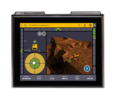
Trimble has introduced its Groundworks Machine Control System, a solution for drilling and piling operations. The next generation system that enables contractors to perform drilling and piling operations quickly, safely and accurately: with centimeter-level accuracy.
Using the large touch-screen display, operators can personalize the interface to match their workflow. In addition, a variety of configurable views make it easier for users to achieve maximum productivity. The software aligns with other solutions in the Trimble Civil Engineering and Construction portfolio to make company-wide training faster and easier.
“Engineered for ease of use, Trimble Groundworks features an updated, intuitive user interface designed for construction environments,” said Scott Crozier, general manager for Trimble’s Civil Engineering and Construction Division. “Contractors can achieve centimeter-level accuracy with stakeless navigation, which reduces rework and decreases the need for personnel working near the machine during operation.”
Drilling. Trimble Groundworks Machine Control System for Drilling gives contractors the ability to drill to the specified location, depth, orientation and inclination angle. Better rock fragmentation and lower hauling costs can be achieved by optimizing drill hole spacing, angles, and the location of the machine for a more even blasting pattern, according to the company. The auto stop feature automatically stops drilling at target elevation to reduce overdrilling, leading to flatter benches and reduced wear and tear on machines, which can result in significant cost savings.
Minimizing the need for stakes and construction surveying, Trimble Groundworks can help promote jobsite safety by reducing the number of people working near the machine while drilling. Also, avoidance zones can be set to keep operators from entering hazardous areas. With Trimble Groundworks, machines can operate 24 hours a day, 7 days a week in almost any conditions, decreasing the chance of delays due to darkness or inclement weather.
Piling. The system enables contractors to increase operational efficiency and reduce surveying costs associated with staking and as-built checks. Navigation time between piles is reduced. Less time moving the machine and more time piling maximizes daily production, which can increase revenue.
Built-in, automated quality assurance and quality control reporting includes the capture of start and end positions, time and elevation as well as actual embedment depth, blow count reporting, and inclination and orientation control. In addition, unique system logins allow managers to filter reports by operator for better accountability, production optimization and forecasting.
Senators Joni Ernst (R-IA) and Tammy Duckworth (D-IL) joined Representatives Dave Loebsack (D-IA) and Don Bacon (R-NE) in launching the Congressional GPS Caucus in March. This bipartisan, bicameral caucus will elevate the ever-increasing importance of GPS technologies to the U.S. economy and infrastructure. As evidence of that, today more than 3.3 million jobs in the United States rely heavily on GPS.
Agriculture is front and center in the states and districts these policymakers represent, and the cost savings as well as jobs and family incomes are noteworthy. Nationwide, GPS has led to $8.2 billion in savings through precision agriculture, while yielding increases in grain production across the country. Further, GPS has become an indispensable and reliable part of the country’s national infrastructure. Public and private investment in GPS-based technologies and services have produced a steady stream of innovations, making the U.S. a global leader in the sector.
The GPS Caucus will prioritize ensuring GPS signals remain continuously available, accurate, reliable and resilient. To better support the long-term health and future of GPS, the caucus plans to host educational briefings and technology demonstrations, in addition to advocating for policies that keep GPS at the forefront. On April 2, these efforts will kickoff with a “GPS 101” educational briefing on the Hill featuring remarks from Senator Duckworth, Representative Loebsack, Colonel Curtis Hernandez, US Air Force Director National Security Space Policy, National Space Council and industry leaders from Deere & Company, Garmin and Trimble.
To further reaffirm the critical importance of GPS, the GPS Caucus introduced concurrent resolutions in both the Senate and House. The resolutions outline the economic benefits of GPS, totaling more than $68 billion to the U.S. economy each year, and the sectors GPS technology supports, none of which would be possible without the contributions made by the men and women of the Air Force who maintain the GPS constellation.
As efforts to advance 5G, precision agriculture and smart cities continue, GPS will only become more valuable to modern-day operations and it remains critical that policymakers, companies and industry leaders alike, foster policy that keeps GPS at the forefront.
Everywhere we turn today, the term “smart” is attached to an item or to a process. Smartphones, smart cars, smart electricity grids, smart home appliances; you name it, someone is making it a “smart” item or process. Advancement in technology has increased computing power, expanded data storage capability, and has allowed for miniaturization of circuits and processors. This forward progress has led to the creation of these smart item/processes, and together creates the real possibility of making many of life’s tasks and normal operations more automated. This potential automation also brings new systems monitoring conditions of various entities and operations within our daily lives, such as increased efficiency of HVAC systems, utility metering that adjusts to our patterns of consumption and landscape watering that only provides water when needed.
In addition to the personal systems now being controlled with these machines, there is now revitalized interest in the creation of “smart cities.” The concept of this type of a civilized urban metropolis once existed only in science fiction, but technology has brought this concept to life in ways not imagined by the best of those writers. Surveyors have a big role in the development, installation and maintenance of these cities, so let us spend some time digging into the element that go into our future environments.
What is a smart city?
For those old enough to remember, the concept of a smart city only existed on “The Jetsons” cartoon from the early 1960’s, with cities in the sky, flying cars and some technological advancements that do exist today. While Orbit City may not come to fruition in the next several generations, many of the concepts of a smart city are taking shape today.
For the definition of a smart city, we go to the Google search engine and find the following entry from Internetofthingsagenda.techtarget.com: A smart city is a municipality that uses information and communication technologies to increase operational efficiency, share information with the public and improve both the quality of government services and citizen welfare.
Establishing a smart city requires forward thinking leadership and substantial funding to be created and maintained; however, the real function lies within the computing infrastructure and collection/manipulation of large quantities of data to create an environment of efficiency and conservation. A true comprehensive system combines available historical data, a collection of sensors and data collectors transmitting real-time information, and a powerful computing system containing analytical programming with extensive database functionality.
Is smart cities technology and adoption really that important?
Population trends worldwide continue to show that urban and suburban areas are expanding while rural areas are seeing a large reduction in residence. Several factors are at play, with technology being the central reason for the migration from the farm/small towns to the bigger cities.
Statistics show that in 1960, two billion people worldwide lived in rural areas while one billion lived in urban sections. As the population has increased drastically, the percentages for each category have reversed; in 2007, the two categories were equal and by 2017, the urban sector has jumped to 4.13 billion versus the rural population of 3.4 billion.
Chart: Our World in Data
Population experts estimate by 2050, upwards of 70 percent of the world’s population will be living in urban areas. Whether this population shift goes directly to the city centers or the less dense outskirts, municipal facilities and services will need to be upgraded and expanded with the continuing trend. Add to this surge the challenge to create a more sustainable environmental infrastructure and ecosystem, and it becomes a maintenance challenge and logistical nightmare. By using technology to create smarter infrastructure monitoring and management systems, the creation of smart cities with advancing technology will be key to successful and sustainable growth for municipalities and its citizens.
One of the biggest challenges faced by most municipalities is aging infrastructure. Utility systems, including water supplies and stormwater drainage, was installed several generations ago without a plan for replacement and/or expansion. Redevelopment in older urban areas are now taxing these aging systems well beyond their initial capacity, all while these facilities begin to fail simply because of continued use well beyond their original designed life span. Municipalities are forced to spend money on repairing and modernizing the existing infrastructure before entertaining the idea of upgrading new installations to “smart city” specifications. However, many municipalities are mandating that new developments and infrastructure improvements meet these specifications so any future upgrades can include computerized systems.
All these systems, new and future, will require extensive planning and mapping to be effective and efficient to justify their expense. Surveyors, utilizing a variety of tools based around high-accuracy mapping and data collection, can provide the necessary base information for these systems.
Where does surveying fit in?
Just as computers and electronic technology has allowed many industries to evolve, the surveying profession has also advanced with new methods and equipment. Our ability to perform advanced measurements and establish positional location information is critical in providing the base data necessary for smart city services. Previous surveying, mapping and record keeping systems were sufficient for the needs of the time period. However, these historical data points were nearly impossible to place into a single database simply because of one factor: georeferencing.
The surveyor has the unique responsibility of being recognized as expert measurer and locator of physical points on the ground in relation to property and boundary rights. It is because of this distinctive role within the community that the surveyor can provide a significant role in the development of the groundwork of a smart city. The introduction and implementation of newer technology and tools has allowed the surveyor to become a valuable member of the infrastructure mapping team. It always hasn’t been this way and the surveying profession shoulders most of that blame.
Past promises: digital vs. smart
Many surveyors will make the argument that our profession has been ahead of the game for years with our data collection processes having been transformed from notes in a field book to electronic devices. Digital data, however, isn’t necessarily smart data as many factors go into establishing the difference. The physical form of the survey information has no direct correlation to the basis of the data; in this case, the records need to be based upon a spatial reference frame rather than an assumed data system.
Also on the topic of spatial reference systems, we can also address the lack of respect given to geographical information systems (GIS) from surveyors during its initial introduction and implementation. GIS was discounted as a convoluted graphical database not sophisticated enough for the high-accuracy world of surveying. Little did the surveying profession know that GIS would become the spatial basis for many mapping systems and be utilized in millions of locations worldwide. Only now does the surveying community realize that we missed the bandwagon and can help to provide the crucial link between spatial data and actual points on the ground in relation to physical improvements and property ownership.
Another digital platform not initially embraced by the surveying community is building information modeling or BIM. This software is a three-dimensional modeling program used mostly by architects and mechanical engineers for depicting and designing buildings and plumbing systems. One of the advantages of BIM versus traditional CAD is a database information link containing data regarding the entities within the BIM. Among the attributes contained with BIM are documentation, spatial reference, time, cost, operational applications, and related applications (contracts, purchasing, suppliers, procurement solutions, etc.). The existing spatial data necessary for this system can be supplied by surveyors using a variety of methods but not many have implemented the software.
Technology, availability, cost of entry and overall usefulness
Surveying instruments and measuring techniques has turned a significant corner in the past two decades. While conventional measurement methods are still used (including steel tapes, laser-based total stations, and GNSS receivers), more types of sensors are being introduced to enhance the accuracy and expand the volume of data points being collected. Scanners, using phase-based and time-of-flight methodologies, are now more popular than ever as ease of use has increased while the cost of ownership has greatly decreased. Ground-based and mobile LiDAR used to be only available to large firms and the government, but new models are being introduced at price points affordable to many surveyors. Many articles have been written regarding the lightspeed adaptation of surveying, engineering and construction firms with UAV use of photogrammetry methods to quickly map areas that were previously inaccessible and meeting standards not thought possible. We are also seeing more implementation of new scanning methods, including SLAM (simultaneous localization and mapping) using handheld and backpack devices.
The common thread for all these technologies and methods is one thing: georeferencing. What was once nearly impossible is now a reality; data collection from various methods all being located within a common horizontal coordinate and vertical datum systems. The ability to obtain literally millions of data points with high-accuracy horizontal and vertical values is phenomenal with most of the credit going to the United States Department of Defense and their implementation of the GPS. Yes, the technology of scanners and data collection would have been invented without the overall coordinate tie-in but having the ability to reference that same data to a common system is the key.
Also key to the smart city data collection methodology is the surveyor as the expert measurer. A trained and experience surveyor can lead the data collection of significant projects, including location of existing improvements and establishment of future installations. From establishment of parcel/right-of-way lines to integration of point clouds from scanners and photogrammetry, the surveyor can assemble this data together to provide the groundwork for successful analyzation and planning. By combining data from various areas of a municipality, including utility atlases, existing improvements, and future expansion plans, a database can be created in which a smart city will rely upon for oversight and monitoring. The surveyor fills a vital role to determining the accuracy and effectiveness of data like no other profession and should not be overlooked when assembling a team for the creation of a smart city.
Future opportunities
Like all technological discoveries and enhancements before, the future is bright with many possibilities to increase the effectiveness and efficiency of a smart city. More types of sensors are being introduced on a regular basis and in every way imaginable, including wireless communication, RFID tags, and microelectromechanical systems (MEMS) devices.
One of the latest buzzwords is the “Internet of Things” (IoT), with many new devices being created to interconnect a network of web-enabled computerized devices using microprocessors, a variety of sensors and wireless communication hardware to gather, transmit and perform actions on information acquired from their environments. IoT presents advantages to users by enabling them to monitor their overall business processes and improve the customer experience. These actions can also precipitate changes to allow the company to save time and money, enhance employee productivity, integrate and adapt business models, make better business decisions, and generate more revenue.
As discussed in previous articles (GPS World March 2018 and GPS World November 2018), the next big technology to look forward to is the telecommunications upgrade to 5G. Once a full 5G network is running with extended coverage, we can look forward to new opportunities for indoor location services with similar accuracy to our existing GNSS capability.
What’s next?
The technology sector will continue to push the limits of computing speed, physical size and data capacity looking for the “next big thing.” The surveying profession has enjoyed many of the fruits of that success so one has to imagine that many more advances will be coming soon. Smart cities will continue to evolve as citizens of Earth keep migrating to the urban areas and forcing the existing infrastructure to expand or face failure. Surveyors will continue to help provide a variety of services to those citizens and municipalities, with an eye on the future for more advancing technology. I can’t wait to see what is next.
Polaris Wireless, a provider of software-based wireless location solutions, announced the commercial availability of a high-accuracy carrier-independent 3D location platform for application developers. By integrating their applications to the new platform, developers can provide end users with pinpoint location, including indoors and in high-rise buildings with floor level accuracy, delivering enhanced situational awareness and improved operational efficiency, according to the company.
Polaris Wireless has integrated its new platform with Orion Labs, Inc., a San Francisco-based company delivering instant and secure voice and location communication.
The Polaris Wireless 3D location platform is cloud-based and is available to application developers via a standard Android and iOS SDK. It can locate devices on the vertical axis within 3 meters, floor level, utilizing all available signals and sensor measurements combined with the company’s patented algorithms. By operating independently, or “over the top,” of wireless carrier networks, the platform is “universal,” enabling applications to locate any device on any network.
“Orion’s customers in hospitality, retail, healthcare, and public safety require pinpoint accuracy on a person’s location inside a building. Polaris Wireless’ platform helps us deliver that location capability, both for teams to see which floor they’re on or room they’re in, as well as to integrate location awareness with Orion Voice Bots and advanced AI-driven services,” said Jesse Robbins, Founder and CEO of Orion Labs.
Orion will demonstrate its solution based on the Polaris Wireless 3D location platform at the International Wireless Communications Expo (IWCE) in Las Vegas March 4-8 in booth No. 3371.
Polaris Wireless CEO, Manlio Allegra, will be participating in an IWCE panel titled “Impact of Enhanced Location Accuracy on Public Safety and 911 Services” on Wednesday, March 6 at 11:45 a.m.
A Chinese cargo ship, the Rongda Changsha, equipped with receivers downloading signals from the BeiDou Navigation Satellite System (BDS), arrived at Brunei, on the north coast of the island of Borneo in Southeast Asia, in February after embarking from Luojing Port in Shanghai. This marks the first public successful application of BeiDou terminal products in the South China Sea and unveils China’s ambition to promote BeiDou products in the international marketplace.
The Shanghai-Brunei trip was a trial for not only examining BeiDou-3’s capacity, but for learning the users’ experience and needs. The data collected from the trip has been analyzed and applied for updating and prioritizing the marine navigation system, according to China Aerospace Science and Technology Corporation (CASC), manufacturer of the Beidou receivers on the ship.
It is anticipated that more services will soon arrive, with Internet and voice calls facilitated by the messaging aspect of BDS, for further exploring industrial application scenarios and — importantly for government support of its GNSS — protecting Chinese outbound and inbound routes. The South China Sea is one of the world’s busiest waterways, and oil imports to China from the Middle East are a key strategic component of this traffic activity.
BDS now covers more than 50 countries and more than 3 billion people. BDS-related products have gained access to the markets of more than 70 countries and regions, more than 30 of which are along the (land-based) Belt and (maritime) Road, in line with the Belt and Road Initiative. Through joint applications with other compatible navigation satellite systems, BDS provides global users with diversified choices for better application experience.
“Chinese security interests encompass not only China itself and nearby areas, but also the sea lanes that enable the import of raw materials and export of finished goods,” wrote Scott Pace in GPS World, December 2010. “In recent years, China has shown an increasing interest in ‘maritime domain awareness,’ in which satellite navigation is used for monitoring the transit of ships in the Indian Ocean (for example, oil from the Middle East) and the South China Sea (minerals from Australia, fishing zones). Satellite navigation is a dual-use, commercial and military, interest for China, and this may have prompted support for the more advanced, independent GNSS that would become Beidou-2 or Compass.”
Pace was chosen by the White House to serve as executive secretary of the National Space Council in July 2017. Pace is also director of the Space Policy Institute and Professor of Practice of International Affairs at George Washington University. He serves as a special counselor to the National Space-Based Positioning, Navigation and Timing (PNT) Advisory Board.
The upgraded McMurdo FastFind 220 and Kannad SafeLink Solo Personal Location Beacons. (Photo: Orolia)
Orolia’s McMurdo FastFind 220 and Kannad SafeLink Solo personal location beacons (PLB) now operate with the Galileo GNSS system.
The PLBs are the first of a series of new solutions coming from the European Union-funded Helios project, led by Orolia, which has been set up to leverage the power of the new satellite system.
With Galileo, the upgraded multi-constellation PLB receivers offer increased global coverage and support accelerated rescue missions. Location detection is enhanced and can be more precise as the PBLs receive coordinates from the Galileo satellite network in addition to GPS. Signals can even be detected in high-sided locations, such as canyons.
“We are thrilled to be launching our upgraded PLBs in the European and U.S. markets,” said Chris Loizou, vice president of maritime at Orolia. “The combination of both Galileo and GPS GNSS capability means that our customers will benefit from coverage that spans from the North to the South Pole. We work tirelessly to push the boundaries of product innovation and, ultimately, to give people the best chance of being rescued in an emergency situation.”
The McMurdo FastFind and Kannad SafeLink PLBs are part of Orolia’s comprehensive search-and-rescue ecosystem and join the McMurdo SmartFind G8 and Kannad SafePro series EPIRBs as Galileo-capable rescue beacons.
Bluetooth has added a new direction-finding feature to help meet the growing demands of the location services market.
The feature, which allows devices to determine the direction of a Bluetooth signal, was added to Bluetooth in version 5.1 of the Bluetooth Core Specification, released Jan. 28.
To make use of the direction-finding feature, Silicon Labs has released new software for the Wireless Gecko portfolio, a comprehensive connectivity solution for the internet of things (IoT).
Silicon Labs’ commercial, industrial and retail customers can enhance their location-based services — indoor navigation, asset tracking, space utilization and point-of-interest engagement — using the direction-finding feature, the company said.
The new feature supports multiple methods for determining signal direction including angle-of-arrival (AoA) and angle-of-departure (AoD).
Silicon Labs’ implementation of the new Bluetooth feature enables detection of signal direction within 5 degrees.
To date, Bluetooth asset tracking and indoor positioning solutions have typically provided location accuracy within a range of 3-4 meters. With the Silicon Labs Bluetooth 5.1 solution, developers can create products that improve location accuracy down to the sub-1-meter level, opening the door to applications previously not possible.
“The Silicon Labs Bluetooth direction finding solution provides a huge leap in location services accuracy for the industry,” said Matt Johnson, senior vice president and general manager of IoT products at Silicon Labs. “The combination of the Silicon Labs wireless solution and the new features added in Bluetooth 5.1 will help developers transform industries and improve people’s lives.”
In addition to improved location services, Bluetooth 5.1 also helps developers:
reduce power consumption with sleep clock accuracy updates.
improve smart home connection performance using GATT caching functionality.
optimize beaconing for Bluetooth mesh in crowded RF environments with the advertisement channel index feature.
“The Bluetooth community continues to find ways to meet evolving market needs and open new opportunities,” said Mark Powell, Bluetooth SIG executive director. “The addition of Bluetooth direction finding demonstrates this commitment to drive innovation and support the incredible growth opportunity within the location services market.”
Silicon Labs’ direction-finding software, including support for the AoA method, is available to customers through the Silicon Labs Simplicity Studio development kit.
Skyworks Solutions Inc. has launched the Sky5 Ultra, an advanced 5G cellular architecture.
The fully integrated, baseband agnostic solution combines all of the critical front-end functionality required to enable high-performance 5G mobile devices with global coverage in a compact form factor.
Graphic: Business Wire
The comprehensive platform features transmit and receive capabilities with high efficiency and output power, enabling reliable network connections while optimizing battery life — both critical for 5G applications.
In addition, the Sky5 Ultra leverages DSBGA packaging to reduce the footprint and advanced TC-SAW and BAW filtering to provide the best performance at each targeted frequency band.
The solution also supports up to 100-MHz wide bandwidth, maximizing data throughput at ultra-fast speeds.
5G rollouts have already begun and will continue to ramp over the next few years. According to the Global Mobile Suppliers Association, 11 worldwide operators have announced limited 5G service launches and seven additional operators have turned on 5G base stations, with commercial services to follow.
“With industry momentum accelerating towards 5G, Skyworks is leading the way with the technological innovations and systems expertise demonstrated by our Sky5 portfolio, a highly flexible and customizable suite designed to meet customers’ global requirements,” said Joel King, senior vice president and general manager of Mobile Solutions at Skyworks.
“Sky5 Ultra represents another breakthrough in simplifying the growing complexity of 5G device development — delivering unmatched performance while expediting deployment through full integration and optimized form factors. We are empowering top mobile device manufacturers and network providers with complete, turnkey solutions that will ultimately bring 5G to realization,” King said.
About Sky5 Ultra
Sky5 Ultra incorporates Skyworks’ high-efficiency transmit, diversity receive (DRx) and MIMO modules with industry-leading noise figure and low insertion loss, in addition to an array of aperture tuners and antenna swap switches for optimal antenna management.
Like all Sky5 solutions, the comprehensive front-end platform supports new 5G NR waveforms and spectrum in addition to enhanced carrier aggregation and 4G/5G dual connectivity, while delivering exceptional levels of integration and performance. Functional core blocks include:
Primary Transmit (Global)
SKY5-8255 – Dual-chain N77/N79 ultra-high–band power amplifier with integrated low noise amplifier and filters (LPAMiF)
SKY5-8254 – N41 high band power amplifier with integrated filter (PAMiF)
SKY5-8265 – Mid-/high-band power amplifier with integrated low noise amplifier and duplexers (LPAMiD) with DSBGA packaging
SKY5-8211 – Low-band LPAMiD
SKY5-8212 – Low-band LPAMiD with DSBGA packaging
SKY77365 – Global system for mobile communications (GSM) power amplifier
SKY13725 – Low band DRx module with DSBGA packaging
SKY13726 – Mid/High band DRx module with DSBGA packaging
SKY13727 – Mid/High band MIMO module with DSBGA packaging
SKY5-3728 – Ultra high-band N77/79 DRx/MIMO module with SRS support
Antenna Management
SKY5-9269 – SP4T 80v aperture tuning and RF distribution switch
SKY5-9256 – 4 x SPST 45v aperture tuning switch
SKY5-9699 – DPDT antenna swap switch
At Mobile World Congress, Skyworks representatives are in the Executive Meeting Area in Hall 2, 2G3Ex and 2G5Ex.
TCarta Marine, a global provider of geospatial products and services, has been contracted by the United Kingdom Hydrographic Office (UKHO) to provide a baseline dataset of water depths and seafloor classification around the Republic of Kiribati.
Located in the Pacific Ocean, the island nation is threatened by rising sea levels.
“Most of Kiribati’s islands average less than two meters above sea level at present and the country’s 110,000 inhabitants are among the most vulnerable to the effects of sea level rise and the world’s first potential climate change refugees,” said Kyle Goodrich, TCarta president.
“We expect to map 5,000 square kilometers in total. Our seafloor maps will be used with other geospatial information by the UKHO to recommend policies that will assist the Kiribati in planning for and responding to this situation,” Goodrich said.
TCarta won the open bid for supply of Satellite Derived Bathymetry (SDB) to the UKHO to extract water depth measurements and seafloor classifications, including habitat types, from multispectral satellite imagery.
In this project, TCarta is processing eight-band DigitalGlobe WorldView-2 and -3 data predominantly, as well as four-band WorldView-4 and GeoEye-1 data to measure depths down to 30 meters at a resolution of two meters.
“The Kiribati project highlights the efficiency and cost effectiveness of SDB technology in a geographic area too remote and enormous for traditional marine or airborne survey methods,” Goodrich said.
The Kiribati nation is comprised of 33 atoll islands and multiple reefs spread over an area of the Pacific Ocean nearly the size of the Continental U.S. Multiple new reefs have been discovered by TCarta using this satellite derived approach at the start of this project.
The islands and surrounding environs have not been mapped in their entirety since the late 1800s. Acquiring bathymetric data and habitat classifications using traditional ship-borne sonar or airborne lidar are prohibitively expensive, logistically challenging and come at far higher cost and timeframe than a satellite-based solution.
“We began tasking the DigitalGlobe satellites to capture images in December and will deliver the final products to the UKHO in early March,” said Goodrich, “DigitalGlobe has been a tremendous partner in helping TCarta meet the project deadlines and challenging open ocean conditions with repeat tasking of imagery, collecting more than 300 images in support of the project, despite the loss of WorldView 4.”
TCarta has developed advanced bathymetric measurement technologies using satellite data. Funded by the National Science Foundation SBIR Phase I grant and known as Project Trident, this new technology is being deployed in the Kiribati project to remotely validate the bathymetry results.
STMicroelectronics (ST) and Virscient are collaborating to enable faster delivery of connected-car systems with ST’s Telemaco3P automotive application processors. Virscient offers support to ST customers in the development and delivery of advanced automotive applications based on the ST Modular Telematics Platform (MTP).
STMicroelectronics is a global semiconductor leader serving customers across the spectrum of electronics applications. Virscient is a provider of hardware and software development services and support for customers building automotive solutions using ST’s Telemaco3P secure telematics and connectivity processors.
Virscient’s connected-car systems rely on technologies such as GNSS (precise positioning), LTE/cellular modems, V2X technologies, Wi‑Fi, Bluetooth and Bluetooth Low Energy.
MTP is a comprehensive development and demonstration platform incorporating ST’s Telemaco3P telematics and connectivity microprocessor. MTP enables the rapid prototyping and development of smart-driving applications, including vehicle connectivity to back-end servers, road infrastructure and other vehicles, the companies said.
The Telemaco3P incorporates Dual-Arm Cortex-A7 processors with an embedded hardware security module (HSM), an independent Arm Cortex-M3 subsystem, and a set of connectivity interfaces. With security at its core, and considerable flexibility in both hardware and software configurations, the Telemaco3P provides an excellent platform for connectivity within the vehicular environment.
“We chose to collaborate with Virscient for Telemaco3P-based designs because of their differentiated expertise in the development of embedded systems and wireless technologies, and their proven track record of helping customers take connected products from concept to market,” said Philippe Prats, head of EMEA marketing and application for STMicroelectronics’ automotive and discrete products. “The Telemaco3P platform enables our customers to deliver new categories and products in automotive telematics. By working with Virscient, we make this exciting technology accessible to a broader range of innovative companies.”
Commenting on the collaboration, Dr. Murray Pearson, CEO of Virscient, said, “We’re thrilled to work with STMicroelectronics to enable more companies to deliver innovative and market-leading platforms using the Telemaco3P devices.”
“ST and Telemaco3P are setting the security standard for processor and connectivity solutions in vehicular telematics. By leveraging Virscient’s hardware and software development capabilities, and our considerable experience with embedded wireless and connectivity technologies, Telemaco3P customers can push the envelope, and get their products to market quicker than ever.”
ST and Virscient are exhibiting the Modular Telematics Platform within the ST Automotive Telematics Ecosystem at Embedded World, ST stand (Hall 4A-138), Feb. 26-28, in Nuremberg, Germany.