Trimble introduced several new geospatial products at its annual Trimble Dimensions user conference, which took place Nov. 5-7 in Las Vegas.
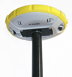
The TrimbleR4sLE GNSS receiver. (Photo: Trimble)
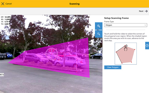
Forensics GNSS Solution. The Trimble Forensics GNSS solution combines the Trimble T10 tablet or TDC100 handheld with the Trimble Forensics Capture software and the Trimble R4sLE GNSS receiver.
The solution enhances forensics fieldwork by improving efficiency and broadening the range of data collection technologies available using the same, proven software. Trimble Forensics Capture software supports GNSS-based workflows and works with the Trimble R4sLE receiver, or any Trimble R-series receivers. Options for data collection now include GNSS, 3D scanners, total stations and unmanned aerial systems.
Forensics Capture field software, designed with the help of law enforcement, uses industry terminology and Wizard-based workflows, making it easy to learn and easy to use.
Built-in ground scaling and local coordinate system for every scene so there is no need for site calibrations.
Integrated surveying workflows for GNSS, Trimble SX10 or total stations.
Storage for all collected data within the same Capture file, including GNSS, total stations or the SX10.
An IP-67 rated Trimble R4sLE receiver, which is protected from dust and capable of withstanding water immersion up to a 1 meter for 30 minutes.
The new solution is expected to available in December 2018.
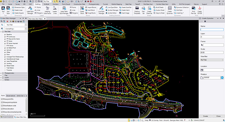
Trimble Business Center v5.0. (Image: Trimble)
New version of Business Center. Version 5.0 of Trimble Business Center merges two products, Trimble Business Center and Business Center – HCE, to provide both surveying and civil construction customers with a complete office software solution. Combining both products into one platform provides a larger set of tools and data interoperability between survey and construction workflows.
New capabilities:
Support for mobile mapping and terrestrial scanning data from systems such as the Trimble MX9 mobile mapping system and the Trimble TX series terrestrial scanners.
Ability to combine high-quality flight data from Delair unmanned aerial systems (UAS) with other sensor data for the rapid creation of vivid orthomosaics and highly accurate surface models. Survey and construction professionals can now integrate these multi-sensor data types within the single software environment.
Intelligent new tools for the creation of computer-aided design (CAD) and geographic information system (GIS) deliverables, corridor inspection reports and tunnel as-built analysis from complex 3D point clouds.
The addition of automated feature extraction, powered by Trimble eCognition software, to dramatically reduce the time to extract features, such as trees, poles and signs, from point cloud data.
New multi-slice capabilities, combined with cutting plane workflows, which allow users to quickly extract cross sections from point clouds at intervals along a linear geometry, further streamlining corridor redesign and maintenance reporting.
Trimble Macro Language (TML), which allows survey and construction professionals to customize data computations and add new CAD and GIS workflows to fit specific local requirements.
New Versions of eCognition Software. Trimble’s eCognition is a software platform for advanced geospatial image analysis for environmental, agriculture, forestry and infrastructure applications.The software extracts accurate geo-information from remote sensing data; eCognition’s intelligent information extraction capabilities accelerate mapping, change detection and object recognition by delivering standardized and reproducible image analysis results.
Updates:
eCognition Suite 9.4 — An improved data management and visualization user interface, algorithms for common feature extraction operations and enhanced 3D data visualization to streamline the development workflow for automatic extraction of valuable information from images and point cloud data. The new capabilities increase the productivity of remote sensing specialists, GIS experts, cartographers, photogrammetrists and geospatial professionals.
eCognition Oil Palm Application 1.3 — A specific solution that provides oil palm plantation managers with valuable information from UAS data that enables them to efficiently manage the plantation. Version 1.3 introduces extended functionality to identify gaps within the plantation to maximize productivity and to enable more sustainable management.
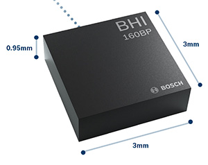
The BHI160BP position tracking smart sensor. (Photo: Bosch Sensortec)
Bosch Sensortec has released the BHI160BP, a position tracking smart sensor that uses integrated inertial sensors to improve GPS location tracking.
Bosch will exhibit the new sensor at Electronica Munich, Nov. 13-16.
When used with a GPS or GNSS module, the BHI160BP enables users to take full advantage of pedestrian position tracking with up to 80 percent saving in system power consumption compared with a typical GNSS-only solution, without compromising on accuracy, the company said.
Users benefit from greatly extended battery life and longer charging intervals for wearable applications such as smartwatches and fitness trackers as well as mobile devices such as smartphones.
The new position tracking approach is set to enable a new class of compact devices with even smaller batteries, Bosch claimed.
The BHI160BP tracks a person’s position by intelligently applying an inertial-sensor-based algorithm for pedestrian dead reckoning. To maintain accuracy, it calculates the user’s relative location based on data collected from the inertial sensors and then recalibrates itself every few minutes to obtain the absolute position provided by the GNSS/GPS module. This means that the GNSS/GPS module can be kept in sleep mode for most of the time, which drastically reduces a device’s power consumption and extends its operating time.
“Pedestrian position tracking is a crucial application for mobile applications; unfortunately, GPS modules can rapidly drain a device’s battery capacity — especially when the battery is as small as in wearable devices,” said Stefan Finkbeiner, CEO of Bosch Sensortec. “Our new position tracking smart sensor solves this problem and enables users to navigate reliably while extending the operation of GPS tracking in their devices from several hours up to several days.”
With the BHI160BP, a device can maintain solid accuracy even when the GNSS signal is blocked or weak, such as near tall buildings or indoors, the company added. This ensures accurate pedestrian navigation at all times, even in shielded indoor areas such as subways, Bosch said.
The BHI160BP is a new member of Bosch Sensortec’s BHI160 family and adds application-specific functionality for position tracking. It provides a ready-to-use solution that can be quickly and easily integrated into a system design without requiring an update to a new GNSS module, thereby significantly cutting time to market, Bosch said.
While the current configuration is optimized for use with GNSS receivers (such as GPS), the BHI160BP can also support most of the common global localization technologies. According to the company, the BHI160BP can handle gesture recognition and 3D orientation, with 3D calculations performed by the sensor itself rather than by an application processor.
The new BHI160BP draws 1.3 mA in active operation mode and integrates the company’s Fuser Core microcontroller and a six-axis inertial measurement unit. The BHI160BP offers a variety of customized virtual sensors, such as a calibrated accelerometer, orientation and wake-up gesture, within a single device. It BHI160BP can be extended by connecting additional physical sensors, such as a magnetometer, over a secondary interface.
The new BHI160BP comes in a compact 3 x 3 x 0.95 mm³ LGA-package and is pin-to-pin compatible with the BHI160. It will be available via distribution in December.
Agriculture equipment maker Case IH is enhancing the robustness of its RTK+ correction signal network by adding the European Galileo system to the compatible satellites with which it works.
The move will increase levels of signal reception and reliability for farmers using Case IH RTK+-guided autosteering and related technologies.
Real-time kinematic (RTK) systems typically depend on signals from the American GPS or Russian GLONASS satellite networks, both designed primarily for non-civilian use. To give European Case IH users a reliable alternative when using RTK+-guided steering systems with their sub-1.5-centimeter repeatable accuracy, Case IH AFS RTK+ now also uses Galileo.
The addition of Galileo to the global GNSS constellation helps minimize the risk of signal failure, a key driver for the integration of its signals into the Case IH AFS RTK+ signal system. European satellite network independence is a principal objective, but Case IH AFS RTK+ is also designed to be compatible with existing and planned GNSS satellites and interoperable with GPS and GLONASS.
Galileo benefits farmers by minimizing downtime from waiting for lost signals to be regained, and ensures consistent efficient use of seed, fertilizer and crop protection products through parallel passes with minimal overlap, thereby maximizing crop potential.
“The use of GNSS technology is opening up new productivity levels and opportunities in European agriculture, providing farmers with an unprecedented level of knowledge about their crops, livestock and operations while making the sector more efficient, economically competitive and environmentally sustainable,” said Maxime Rocaboy, product marketing manager, AFS technology, at Case IH.
“Enhanced RTK+ accuracy through incorporation of signals from the Galileo satellite system is a core way in which we can help Case IH tractor and combine users be innovative and competitive as they seek to help develop a sustainable agriculture to feed an ever-increasing world population in an environmentally responsible way,” Rocaboy said.
On Saturday, Nov. 10, Stanford colleagues of Professor Per Enge will host a celebration of his life. A live webcast of the event will be available here at at 1 p.m. Pacific Standard Time.
The video will be available afterwards on this site.
GPS World extends this invitation to join Per’s family and friends in celebrating the wonderful life that he led and the extraordinary impact he had on those around him. Guests at the live event will be invited to share their favorite memories.
The following statement was recently read into the minutes of the Stanford Faculty Senate:
Per K. Enge, the Vance D. and Arlene C. Coffman Professor in the School of Engineering and one of the world’s foremost experts in GPS technologies, passed away on April 22, 2018, at his home in Mountain View, California. He was 64.
Per Enge, Professor and Director, Stanford University Center for Position Navigation and Time. (Photo: Stanford University)
Per was born Oct. 29, 1953, in Bergen, Norway. He immigrated at the age of 2 to the United States with his father and mother.
He earned his B.S. in electrical engineering at the University of Massachusetts at Amherst in 1975 and his MS and PhD at the University of Illinois Urbana-Champaign in 1979 and 1983, respectively. He met his wife of 38 years, Elaine, while at UMass. His son, Nick, a Stanford graduate and now a lecturer at the University of Texas at Austin, said that despite his academic upbringing, his dad was a middling student until Elaine introduced him to the library at UMass, where she was most often found.
While pursuing his advanced degrees, Per worked in industry, where he first gained experience using radio signals for terrestrial navigation. He then took a position as assistant professor at Worcester Polytechnic Institute, where he designed a radio-navigation positioning system that today has more than 1.5 million marine and land users. He also started to work on augmenting GPS so that it could be safely used for aeronautical navigation. Due to this effort he was recruited by Stanford University for a one-year visiting professorship in 1993 that was ultimately extended to full professorship.
While at Stanford, Per became one of the FAA’s most trusted advisors on the provision of aircraft guidance. He oversaw the development of two different systems that today allow airplanes to safely determine their positions within meters regardless of the weather conditions.
Per was a member of the National Academy of Engineers, a Fellow of the Institute of Navigation, and a Fellow of the Institute of Electrical and Electronics Engineers.
Per is particularly remembered as a teacher and mentor. He designed a freshman course in electric cars and aircraft and helped launch a popular massive open online course (MOOC) for the GPS community outside Stanford. He leaves behind a strong legacy of more than 40 Ph.D. students, co-workers and colleagues who have been inspired by his genuine joy in being able to work in such an exciting field.
Per is survived by his wife, Elaine, of Mountain View, and a son, Nick, of Austin. In lieu of flowers, donations in Enge’s memory can be made to a new graduate student scholarship fund under the Stanford department of Aeronautics and Astronautics. Donations can be made at https://gps.stanford.edu/resources/giving
Regular readers of GPS World are aware of many of the rapidly developing technologies and navigational systems being created around the world, but often the everyday surveyor shows up late to the party.
While smartphones get the most mainstream media coverage, other navigational devices and measurement systems are adapting to evolving technical breakthroughs and new methods of transmitting a variety of data wirelessly.
This month’s article looks at the increase in satellite navigation networks along with the rollout of 5G cellular technology. Both advancements will benefit the surveying community; to start, I’ll explain what this means for accuracy and precision of survey measurements as well as productivity.
Everybody gets a constellation! (with apologies to Oprah)
I’ve been known to wax poetic in this column about my admiration of GNSS technology, and I continue to marvel at the “accidental” civilian use of a military tool. This method of measurement and navigation continues to expand, refine and transcend everyday life, and surveying is no exception.
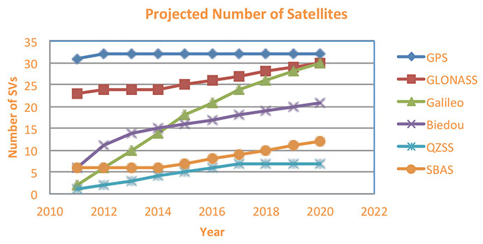
The satellite constellation is the mainstay of this navigational system. The United States began the charge several decades ago, but other nations are quickly catching up. Let’s look at the current constellations and their status.
Operational Systems
GPS (United States)
GLONASS (Russia)
Galileo (European Union)
Beidou (China)
QZSS (Japan)
IRNSS (India)
Chart: GPS World
There are now more satellites. What’s the big deal?
The addition of these constellations provides large gains for the surveying community in several different ways.
First, the additional satellites mean more signals to help with the mathematical equations necessary for positional determination. While traditional surveying in the general public’s eye is associated with measurements on the ground, our expansion of services into the air and water relies heavily on GNSS determined positions.
No matter what type of remote sensing equipment is being used (lidar, photogrammetric, sonar, etc.), positional determination for most of those sensors are derived from GNSS-based receivers. Add to these measuring methods the ability to perform operations via remote-controlled or autonomous vehicles in both air and water, and the availability of additional satellite signals enhances the reliability of GNSS-derived data and attributes.
Second, by having more satellite signals to utilize, GNSS receiver manufacturers can improve the software for processing the positional information with greater certainty of accuracy.
Before the introduction of additional constellations and receivers with expanded signal reception, GNSS users relied on less sophisticated software to identify potential “bad” signals that would lead to incorrect positions. While the software generally provided reasonable reliability, it was not foolproof and occasionally would allow bad data to be accepted.
Like most everything tech-related, however, the GNSS industry has benefited from increased computing power to go along with the additional satellite constellations. The latest GNSS receivers can accept well over 500+ signals from a variety of sources (including land-based transmitters). The software used to reduce all that data has increased in complexity along with number of those data sets.
Complex computations that were once limited to mini-computers or even mainframes are now being completed on handheld data collectors in minuscule timeframes compared to their predecessors.
The software has also been enhanced to analyze the data in real-time, compute the likely position of the receiver and notify the user of potential incorrect or “spoofed” data from any number of satellites.
Considering that many of the remote-sensing sources now collect millions of points based upon one GNSS-based position, the need for increased positional verification has become a critical issue. By having many more constellations to provide signals for positional data, the percentage of establishing a correct location for each data point has increase significantly.
The improved computing power and verification ability of today’s GNSS software is helping to eliminate errors in positional accuracy and instill more confidence in the surveyor’s data collection activities.
Add to these additional constellations the planned installation of more land-based signal providers to augment or provide a backup plan for satellite systems, and it’s clear that the future is quite bright for GNSS-based receivers and data collection for everyone — especially the surveying community.
The history of wireless communication
While surveyors marvel at the advancements of GNSS-based measurement, it pales in comparison to the rapid growth of modern technology with cellular devices. Notice I didn’t write cellular phones, as the technology has quickly established itself as much more than voice communication. Before we lay out the future of cellular data networks, let’s take a step back and see how this type of communication has revolutionized GNSS-derived data collection for surveyors and others.
Two-way, CB and shortwave ham radio
1947 two-way radio advertisement. (Image: Motorola)
The technology behind wireless communication goes back several decades, but didn’t become a mainstream system until the late 1970s and early 1980s. Motorola is known as the early force behind the two-way radio system, but the base and remote transmitters were not cost effective for small businesses. This type of system was also limited to single-purpose radios with individual crystals wired within that only allowed specific frequencies to be transmitted.
Another type of communication used by some was the citizens band radio, affectionately referred to as CB radio. This radio was limited to 40 channels and didn’t allow for private transmission between two parties. During the 1970s, the use of the CB radio was not limited to long-haul truck drivers — many people used the medium for basic communication.
Vintage CB radio ad from Radio Shack. (radioshackcatalogs.com)
Telephone service during these times was still costly and long-distance calls were not cost-effective, so many found the CB radio as an alternative to conventional phone service. Looking back now, it is not a stretch to classify this type of broadcasting as a primitive social media precursor to today’s methods but limited to live chats and no visuals.
Another method of transmission was short-wave radio. This system was like two-way radios with an established base transmitter, but broadcast on public frequencies over greater distances than CB radios. One of the big drawbacks was the upfront costs, which were much more significant than the other radios. Even more expensive was outfitting a vehicle with a shortwave system, so cost was the biggest limiting factor for this mode of communication.
Pagers of all shapes and sizes
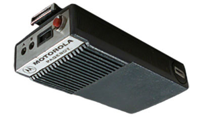
Motorola’s Pageboy pager. (Photo: Motorola)
The popularity of telephone-based pagers didn’t hit its zenith until the early 1990s, but the technology and actual use dates to the early 1960s. The first commercial pager was produced by Motorola in 1964 and called the Pageboy. There was no screen or display; the user was notified by a variety of tones preset for distinct situations or needs. As this technology advanced, variations in screens, message types and even two-way communication became possible.
By 1994, there were more than 60 million pagers in use, but a change was in the technological wind; cellular phones were marching toward the mainstream.
While the concept of wireless telephone communication existed in several laboratories around the world for years, the first big breakthrough was made by researcher Martin Cooper, who developed a prototype cellular device for Motorola in the early 1970s. He famously made the first public cellular phone call on April 3, 1973, to Joel Engel, head of research at Bell Labs, during a walk in New York City. Cooper and Engel were engaged in a rivalry to develop the first commercially available cellular phone with the Motorola DynaTAC prototype being the first to make a successful call.
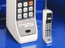
However, the rush to get cellular phones to market took longer than anticipated. It wasn’t until the introduction of the Motorola DynaTAC 8000 in 1983 (available to the public in March 1984) that the reality of wireless phones came to life. The cost of wireless freedom came at a price: $3,500 for a brick-sized phone that took 10 hours to charge for 30 minutes of use. The cost of the service was also expensive due to the limited cellular infrastructure.
The next decade brought us expanded cellular coverage along with miniaturization of phone; each subsequent model provided more features and longer battery life. From the Nokia “candy bar” to the Motorola Razr, the cellphone era had engulfed the mainstream, but more changes were ahead for mobile communications.
The late 1990s saw the introduction of the cellphone as a computer modem, with limited email connectivity and primitive internet browsers built into the operating systems. But like many electronic technologies that came before, the cellphone would begin a radically different life in the mid-2000s.
Enter the smartphone to help us dummies
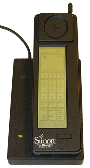
The IBM Simon Personal Communicator and charging base. (Photo: IBM/public domain)
Officially, the smartphone has been in existence since 1992 with the creation of the Simon Personal Communicator from IBM. At a cost of $1,100, with a monochrome screen that was 4 ½ x 1 ½ inches, the Simon allowed the user access to email and faxes (remember those?) along with the phone function — but users had to make it fast; the battery only lasted an hour. IBM sold 50,000 of these units before pulling the plug on the project, but it started the trend toward mobile telephones with a graphical interface and extended uses beyond the standard verbal communications.
Just like the Apple Newton was the failed precursor to the Palm Pilot, various tablets and eventually today’s smartphone platform, the Simon broke ground and established new directions for future communication.
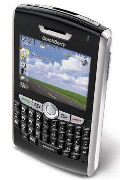
The early 2000s introduced us to the Blackberry personal digital assistant (PDA) and phones from Research in Motion (RIM), a small electronic communications company from Ontario, Canada. RIM started small with a two-way paging system that became popular in Europe and quickly morphed into cellular devices that worked on the DynaTAC network used by Motorola.
A recent model Blackberry PDA. (Photo: Blackberry)
By the mid 2000s, their devices became affectionately known as the “Crackberry” as users became addicted to the functions and capability of this communication tool. These devices were popular with business users as the security encryption was considered more effective than any of the other communication apparatuses of the day.
By 2009, Blackberry had reached the zenith of the mobile device market (second only to the conventional mobile-phone platform dominated by Nokia) but began a rapid decline due to proliferation of the next big thing — the touchscreen smartphone.
After Apple’s introduction of the iPhone in 2007, followed by a crowd of Android-powered phones in 2008 and beyond, Blackberry’s market share has been reduced to a small niche group.
And now, why this relates to the surveyor…
The rollout of Steve Job’s dream of combining Apple’s industry-defining iPod with mobile phone capability revolutionized not only the way we communicate — it has redefined our everyday environment. Many of the tasks we accomplish every day have been incorporated into a smartphone application, which brings us back to the reason this article is directed at surveyors: the device that hangs on your belt or rests in your pocket is revolutionizing the way today’s surveyors work.
Not that long ago, the only navigational devices available were large, expensive and difficult to use. Now, nearly everyone owns a device with GNSS capability. When we combine the ever-expanding number of devices along with the increased coverage of GNSS satellite constellations, the ability to georeference any piece of data to greater precision and accuracy is improving.
Surveyors need to embrace this technology within their smartphones to increase their efficiencies. At the same time, we need to help educate the public on why having better smartphone location capability doesn’t mean the masses can perform their own boundary analyses. For more information on this subject, see the GPS World July 2017 article.
Surveyors should embrace the smartphone as an important tool; the introduction of new survey-grade GNSS receivers that use an app for the user interface will soon become commonplace.
Several GNSS manufacturers have introduced receivers that exclusively use a smartphone and app for data collection, eliminating the need for a dedicated (and usually proprietary) data collector for obtaining centimeter-level location data. I’m not advocating that the surveying community throw their existing systems in the trash in favor of these newer receivers, but the data-collection techniques utilized by smartphones can increase efficiency and reduce equipment costs.
The Mi 8 smartphone offers dual-frequency capability. (Image: Xiaomi)
Another reason to pay attention to the smartphone as a location tool will be the expanded use of dual-frequency chipsets to provide even higher accuracies. One of the fastest growing phone makers worldwide is Xiaomi, based in Beijing, China, which introduced the Mi 8 phone with a dual-frequency GNSS chip. This chip frequency reception (E1/L1+E5/L5) is targeted to embrace the Galileo and GPS constellations for increased accuracies (within a decimeter), well beyond the current norm for smartphones (typically 1-3 meters, plus or minus). For the surveyor, having this capability in their pocket can greatly increase efficiencies, especially when used during reconnaissance efforts. I believe many more phone manufacturers will begin to incorporate dual-frequency chips in their future models to increase location accuracies for users and take advantage of upcoming network enhancements.
Speaking of network enhancements, let’s talk 5G as a gamechanger.
The latest buzz in the general population’s lexicon is 5G and how it will push high-speed internet to all corners of the world. While this is a possibility, it means much more to the surveyor than meets the eye. Yes, there will be increased cellular coverage in places that previously lacked it, or only had limited access, but 5G means much more than that.
Image: NTT DOCOMO Inc. 5G white paper.
Let’s refresh our view of what cellphone coverage currently means to the surveyor. The use of cellular-based RTK receivers has been greatly expanded due to the increased coverage of 4G LTE signals throughout the world, but it’s still scarce is some parts. This is mostly due to the transmission of cellular signals being required from towers and higher placed antennas with powerful transmitters. These transmitters are costly and typically owned and installed by the larger telecom companies, so placement is traditionally in more populated areas.
Enter 5G — while it will provide enhancements for all users, it will be revolutionary for the surveyor. 4G cell coverage was a broad and powerful signal from large transmitters; 5G cellular service consists of smaller cell signals placed in a tight grid of broadcast positions. These transmitters will be more cost effective for many telecom providers and will increase data reception for many users. For surveyors, the additional coverage of 5G will make possible the use of cellular-based RTK GNSS data collection in places not previously possible.
Besides the extended coverage of 5G, the 10-fold speed of the new data transmission protocol compared old 4G LTE creates many possibilities for information collection growth. Soon it will be possible for a field personnel and the office staff to be linked in real time during the data collection process.
From boundary-point recovery to complex topographic surveys, a field crew’s work can be supervised and reviewed while being completed, allowing for instantaneous analysis and guidance from senior staff. This process will allow for more oversight, quality control and mentoring of field staff than is possible for today’s remote crew operations. The new technology will also allow for reduced timeframes when crews are required to provide field data for tight deadline requests and gives us a method of instant feedback on the amount and quality of the data collection.
Some may see this improvement in connectivity as an avenue for office staff to be intrusive on their field activities, but I see this as an opportunity for improved quality control and increased team interaction. More connected teams can lead to improved efficiencies and overall increases in productivity, profitability and morale among team members.
From outside to inside
Another breakthrough created by 5G will be the enhancement of indoor georeferenced location services. By having several transmitters placed throughout a facility, trilateration will be possible to provide more accurate location information for places not typically available to surveyors.
Depending on the accuracy needed and placement of the cell providers, it will possible for surveyors to use devices designed for remote sensing (laser scanners, lidar, SLAM, etc.) and collect georeferenced data with greater accuracy in relation to a known coordinate system. This by-product will also aid rescue and medical providers during emergencies to help pinpoint individuals through their cellphone connection more accurately than before.
5G is more than just bringing YouTube videos to your phone faster; it will improve the data collection process of all shapes and sizes. Surveyors will not get left out, but we will need to be ready to take advantage when it comes online. For more on the 5G revolution, see the GPS World February 2018 article on this topic.
As surveyors, just when we think that technology can’t take us further, we blink and change happens. Moore’s law stated (depending on which revision) that technology would double the number of transistors every one to two years. While some may say that technology is making Moore’s law obsolete, I believe the creativity being used to invent new processes based upon the technology is holding strong.
I, for one, look forward to many more enhancements to follow in the coming years. Surveyors be ready; the future is here.
A free lesson for those in charge of critical infrastructure systems such as the power grid, communications, financial markets, emergency services, and industrial control.
Many of these systems have functioned smoothly and efficiently for years, thanks to the precise timing provided by GPS receivers. That could change, suddenly and without warning, if predictive and preventative steps are not taken.
The GPS receivers somewhere near the hearts of these critical systems, if not thoroughly vetted, tested and checked for up-to-dateness, could constitute a vulnerability — a vulnerability that would be catastrophically exposed on April 6, 2019. In 6 months’ time.
Image: Orolia
The GPS constellation transmits the proper date and time to all receivers, worldwide, by supplying the current week and the current number of seconds into the week. This enables the receiver to translate the date and time into a more typical format: day, month, year, and time of day. Infrastructure systems use the precise timing to synchronize many complex operations across their respective networks. Critically, the field that contains the week number is a 10-bit binary number. This limits the range of the week number to 0 – 1023, or 1024 total weeks.
GPS week zero started January 6, 1980. The 1,024 weeks counter ran out and rolled over on August 21, 1999. The week counter then reset to zero, and it has been recounting ever since. The next time the counter will reach week 1,023 and roll over to zero is on April 6, 2019.
If the GPS receiver is new or has received firmware updates, it can accommodate and adjust for this change. But do you know for sure? Only if you test. Otherwise, your critical systems may go into a time warp, 19.7 years out of date. Visualize that discrepancy rippling outward from the core component of a critical timing system throughout your infrastructure. Or, simply not working at all.
It is incumbent upon all managers to verify that such an issue will not occur — well before its possibility arises. At a minimum, experts recommend consulting your receiver manufacturer to confirm that the issue has been fully tested and will not occur. Many manufacturers have already issued compliance statements, and are expected to continue doing so over the next year, up until the event occurs.
To be sure that your system will not experience any failures related to this issue, it is possible to test for this event using a GPS/GNSS simulator. The requirements for the simulator are straightforward. The basic yet key information necessary to undertake such testing will be communicated in a free webinar on Thursday, November 15.
The panel of expert speakers includes Lisa Perdue, product manager and applications engineer, Orolia; Stefania Römisch, leader, the Atomic Standards Group at the National Institute of Standards and Technology; and Dana Goward, president, Resilient Navigation and Timing Foundation.
You may register for this free webinar here, to attend it live or download it for later viewing at your convenience.
Here is a useful reference from the last time the rollover occurred, with a mention of the next one.
Photo: Technical University of Eindhoven
Eindhoven, the Netherlands, is home to the Eindhoven University of Technology, an incubator for technology startups where many scientists active in GPS research and in the direction of the Galileo satellite navigation program have trained.
Tectonics is the study of plates in the Earth’s crust that move in different directions and speeds. To study plate motion, GPS instruments are anchored firmly in bedrock to measure how it moves, infinitesimally yet measurably, thanks to the nanosecond timing provided by the GPS constellation and interpreted by properly calibrated and updated instruments.
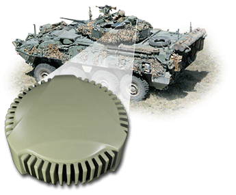
NovAtel’s GPS Anti-Jam Technology (GAJT) now rides into battle and military exercises aboard the Canadian Army’s Artillery Observation Post Vehicles (OPV) that have been fitted with the GAJT‑710ML antenna.
OPVs are highly mobile vehicles that perform observation, reconnaissance and patrolling missions, surveying and acquiring strategic targets and relaying instant, accurate target coordinates acquisition to artillery fire command systems. With their exposed position on the frontlines of the battlefield, OPVs can encounter severe GPS jamming aimed at crippling their capabilities. OPVs require reliable Position, Navigation and Timing (PNT) not only to safely and effectively navigate on the battlefield, but to provide reliable information to artillery in the rear.
GAJT provides protection for GPS navigation and precise timing receivers from intentional jamming in electronic attacks, ensuring that the satellite signals necessary to compute position and time are always available.
“GAJT allows us to have confidence that the position information from the GPS constellation is assured.” said Major Mike Moulton, the project manager in the Directorate of Land Communication Systems Program Management.
NovAtel’s GAJT is a retrofittable system. A military-off-the-shelf (MOTS) product, it comes in versions suitable for land or sea applications and smaller platforms such as unmanned aerial vehicles (UAVs). The antenna works with an array of military and civil receivers, including the Army’s handheld Defense Advanced GPS Receiver (DAGR), other military receivers using SAASM and M-Code, and with civil receivers.
“GAJT scrubs off unwanted signals. It differentiates between what we can recognize as a signal coming from a satellite and something anomalous, which could be interference or deliberate jamming,” explained Peter Soar, NovAtel’s Business Development Manager for defence. “GAJT does not contain a GPS receiver, but works with the receiver that’s already installed. So GAJT faithfully passes the good satellite signals to the receiver which then operates functions such as integrity monitoring in its normal way. GAJT is in use operationally and has been shipped to 16 allied nations around the globe.”
GAJT is a null-forming antenna system that ensures that satellite signals necessary to compute position and time remain available. There is no need to replace the GPS receiver that’s already installed, as GAJT works with both civil and military receivers operating in the GPS L1 and L2 bands. It is ready for M-Code, is a non-ITAR product and is readily available to authorized customers.
Trials with the Canadian Army’s testing unit validated the technology, maintaining access to the GPS signal in an adverse signal environment. It also gave NovAtel engineers a detailed unclassified report on the trial findings and recommendations. The feedback helped NovAtel modify GAJT into a stronger product. The GAJT-710ML antennas were delivered earlier this year, and the Army worked with General Dynamics Missions Systems Canada, the prime contractor for the mission systems on the OPV, to integrate the antenna aboard the vehicle.
“GAJT is a Canadian success story. It is 100 percent produced in Canada and sourced from Canadian components. I think that the Directorate of Land Communication Systems Program Management have shown there is excellent technology in Canada that can be leveraged to meet the Army’s requirements in a very rapid manner,” added Moulton.
This story uses some quotes that first appeared in “Out of a Jam,” an article by Chris Thatcher in Canadian Army Today.
Daimler Trucks to connect with AT&T. (Photo: Daimler)
AT&T provides connectivity for DTNA’s Detroit Connect platform across the U.S. and Canada. The Detroit Connect platform is installed on all new DTNA’s Freightliner Cascadia trucks built for customers in those countries. The relationship will now expand to cover trucks built for the Australian and European markets for 2018 model year Freightliners and newer.
The new Cascadia sets new standards in fuel efficiency, safety technologies and the latest connectivity solutions, DTNA said. Detroit Connect, connected by AT&T, enables enhanced safety reporting, powertrain diagnostics and software, and features over-the-air updates and fuel efficiency analytics capabilities for vehicles across North America.
New multi-year agreements cover Australia, Austria, Belgium, Bulgaria, Czech Republic, Denmark, Finland, France, Germany, Greece, Hungary, Ireland, Italy, Latvia, Lithuania, Netherlands, Norway, Poland, Portugal, Romania, Spain, Sweden, Switzerland and the United Kingdom.
AT&T has reached other milestones in the connected car space. According to the company, it has accomplished the following:
It has 24 million connected cars on the AT&T network, and added 2 million this year.
AT&T connects more than 3 million fleet vehicles, specifically supporting small business, enterprise and government customers.
The company has relationships with 29 global brands including Airstream, Audi, BMW, Ford, Mercedes-Benz, GMC, Honda, Volvo and much more. AT&T has worked with its partners on 4G LTE connectivity, enhanced infotainment services and greater Wi-Fi accessibility.
The company’s global SIM provides internet of things (IoT) connectivity across 500 carriers and 200+ countries and territories. AT&T also connects cars in 57 countries, including 12 where infotainment is enabled through Wi-Fi hotspots.
“We’ve had tremendous success in launching our proprietary connected vehicle platform with AT&T” said Jason Krajewski, director of connectivity at Daimler Trucks North America. “Working with AT&T, we will expand our connectivity services and connected vehicle portfolio to more vehicles and more regions.”
“Daimler Trucks North America is the industry leader in bringing IoT connectivity and innovative solutions to long-haul trucking industry,” said Chris Penrose, president, internet of things (IoT) Solutions at AT&T. “Broadening our collaboration outside North America for the first time will bring the benefits of efficiency, safety and performance to customers on a global scale.”
Trimble introduced several new products at its annual Trimble Dimensions user conference, taking place Nov. 5-7 in Las Vegas.
Photo: Trimble
GNSS Smart Antennas for Civil Construction. The new SPS785 GNSS smart antenna is a fully capable GNSS receiver that features high-quality GNSS accuracy at a lower price point. The SPS785 has full satellite coverage with the combination of GPS and all GNSS constellations. A seamless workflow with the Trimble Siteworks Positioning Systems means that everyone on the jobsite can use the same data and work on the same platform.
For added protection, the SPS785’s radio antenna fits inside the range pole. The lightweight and compact design enables contractors to work longer with less fatigue.
Also, a new dynamic tilt functionality was added to the Trimble SPS986 GNSS smart antenna. The SPS986 is specifically designed for rugged jobsite measurement applications, and is now available with a dynamic tilt upgrade. The dynamic tilt feature allows for faster data collection to enable construction surveyors to create larger digital terrain models faster and with improved accuracy. It is designed to capture higher accuracy measurements on steeper slopes from a moving vehicle and more accurate volume measurements to save time and money on material planning.
The dynamic tilt measurement mode also auto-measures antenna height. From inside the vehicle, contractors can set the height of the antenna and quickly interrogate surface models using the real-time 3D surface display in Trimble Siteworks field software.
The Kestrel seismogeodetic system. (Photo: Trimble)
Kestrel Seismogeodetic System. Trimble RTX technology is now delivered via satellite to the Kestrel seismogeodetic systemfor earthquake, volcano and infrastructure monitoring. Designed for scientists and structural engineers, Trimble’s Kestrel pairs uninterrupted, high-quality GNSS positioning corrections with seismic data — for Earthquake Early Warning (EEW), volcano and infrastructure monitoring of bridges, dams, towers and other civil structures.
In addition to internet-delivered Centerpoint RTX corrections, the Kestrel system also now supports L-band satellite delivered RTX corrections. This ensures corrections are not affected during communication delays or outages that occur during natural disasters. CenterPoint RTX enables centimeter-level absolute positioning, which is critical when analyzing and responding to the movement of a structure.
Field Staking and Design Solution for Electric Utilities. Trimble Field Designer is an innovative mobile staking and design solution that enables electric utilities to quickly design overhead and underground electric utility lines on mobile devices in the field.
Trimble Field Designer leverages mobile technology from Trimble business partner GeoSpatial Innovations, Inc. (GSI). It was developed to add new field staking and design capabilities to Trimble’s Network Information System (NIS), a network asset management solution. At the heart of Trimble NIS is a fully connected “live” network model built on a single database that provides for comprehensive documentation, topology and full life-cycle support of electric utility network assets.
Trimble Field Designer enables electric utilities to:
Capture pole locations efficiently and accurately
Measure distances, angles, elevations, offsets, and bisectors
Assign construction units to locations and spans for material and labor requirements
Capture comments and information about design
Reduce design time
Eliminate redundant data entry in the office.
Earthworks Grade Control Platform version 1.7. The latest version of Earthworks provides support for motor graders and automatic guidance for tiltrotator attachments. Trimble Earthworks for Motor Graders is a GNSS-based, 3D-grade control solution designed to make fine grading more accurate, faster and easier. In addition, Trimble Earthworks now gives excavator operators using tiltrotators the advantage of automatic machine control, which can result in increased productivity.
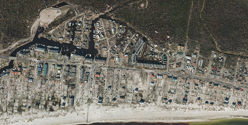
Correlator3D was used to process large format imagery collected by Midwest over Mexico Beach, Florida. (Image: SimActive)
SimActive Inc., developer of photogrammetry software Correlator3D, has partnered with Midwest Aerial to perform damage assessments of Hurricane Michael.
Correlator3D was used to process large format imagery collected by Midwest over Mexico Beach, Florida. The joint effort resulted in highly precise geospatial data, including a digital surface model (DSM), an orthomosaic and a 3D model, the company said.
“This is a terrible disaster for the people affected and we hope they can benefit from geospatial technologies available,” said Philippe Simard, president of SimActive.
The gallery below shows samples of the imagery collected.
SimActive partnered with Midwest Aerial to perform damage assessment of Hurricane Michael. (Photo: SimActive)
Correlator3D was used to process large format imagery collected by Midwest over Mexico Beach, Florida. (Image: SimActive)
Aerial imagery of the devastation from Hurricane Michael in Mexico Beach, Florida. (Image: SimActive)
SimActive’s Correlator3D is a patented end-to-end photogrammetry solution for the generation of high-quality geospatial data from satellite and aerial imagery, including UAVs. Correlator3D performs aerial triangulation and produces dense DSM, digital terrain models, point clouds, orthomosaics, 3D models and vectorized 3D features.
Powered by GPU technology and multi-core CPUs, Correlator3D ensures high processing speed to support rapid production of large datasets, the company added.
Midwest Aerial Photography focuses on acquiring high-quality aerial imagery and companion data in support of photogrammetric mapping projects across the United States and Canada. Midwest partners and clients include federal, state and local government agencies, as well as photogrammetric firms and architectural and engineering companies.
Telit GE310-GNSS IoT Module fills European demand for GSM/GPRS compact form factors, and is part of Telit’s migration-support program that helps customers leverage 2G’s low cost and broad coverage while preparing for 4G and 5G.
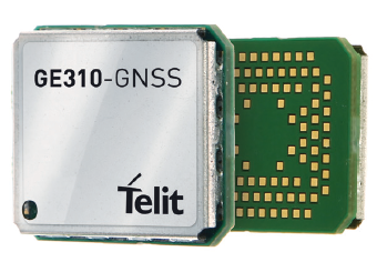
The GE310-GNSS module. (Image: Telit)
Telit has released the GE310-GNSS, an internet of things (IoT) module with GSM/GPRS, multi-constellation satellite positioning and Bluetooth functionality in a 270-millimeter-squared form factor.
The GE310-GNSS enables original equipment manufacturers (OEMs) and system integrators in application areas such as asset management, utilities and telematics, meet strong demand for low-cost, highly compact devices without tradeoffs in performance, reliability and functionality, particularly in regional markets such as Europe, where 2G is forecast to remain in strong growth in number of IoT connections for many years.
The GE310-GNSS features a miniature form factor packaged in an LGA 94-round-pad format. It is designed to meet the robust demand in Europe, Latin America and other regional markets for compact devices such as health and wellness monitors, smart residential and commercial thermostats, commercial fleets and IoT-connected grid equipment for smart utilities.
With support for Europe’s Galileo as well as other satellite positioning constellations, the GE310-GNSS is suitable for IoT applications that require location awareness throughout Europe and the rest of the world. The module’s Bluetooth 4.0 capability makes it easy for OEMs to add connectivity to proximal area network devices, Telit said.
The GE310-GNSS is part of Telit’s future-proofing program, which helps customers leverage 2G’s low cost and gapless European coverage immediately while retaining absolute control of when they switch to a compatible 4G module in the Telit family lineup.
The lineup includes multiple roadmap paths to upgrade to 4G and later to 5G based on the customer business strategies and specific market conditions.
Research firm ABI Research estimated in its “ABI IoT Market Tracker – Worldwide – October 2018” that 2G cellular IoT connections will continue to grow in Europe from 100 million in 2018, reaching a peak of 148 million connected devices in 2022 before slowly dropping to about 89 million in 2026.
“The GE310-GNSS is the newest in our lineup of updated 2G modules for markets like Europe and Latin America which still show a sustained pull for over half a decade,” said Yossi Moscovitz, president products and solutions, Telit. “This svelte module combines proven, reliable 2G connectivity with the latest satellite positioning and Bluetooth technologies, all backed by Telit’s decades-enduring migration-support program. Telit has helped thousands of customers through cellular generational transitions and is now helping 2G customers in Europe, Latin America and other regions develop business-enhancing roadmaps to 4G and 5G.”
For more information about the GE310-GNSS and other Telit IoT solutions, visit booth A.b80 at European Utility Week, Nov. 6-8 in Vienna, Austria.
Representatives from the global automotive industry gathered at the the Intelligent Transport Systems (ITS) World Congress in Copenhagen in September. At a “Galileo for Mobility” session, panelists showed off new products and discussed the benefits of GNSS for the deployment of multimodality, new mobility services and digital platforms by transport authorities, industries and users.
Their goal: to make safe driverless road transport a reality.
Autonomous driving with multi-GNSS
Cover image of Galileo for Mobility leaflet. (Image: GSA)
Germany’s ANavS GmbH provides position and attitude solutions with centimetre-level accuracy. Fast fixing is achieved by using three GNSS constellations and the company’s patented RTK fixing technology. The system combines multi-GNSS (GPS + GLONASS + Galileo), inertial sensors, vehicle data, visual odometry and feature mapping, as well as LiDAR and radar. Tight coupling of GNSS and all of these other systems ensure reliable positioning even in areas with limited satellite visibility.
ANavS managing director Patrick Henkel said, “Our sensor fusion framework delivers precise position and attitude information for navigation. It also generates real-time, highly accurate maps with high resolution. The platform can be used for the whole range of transport applications from road transport to maritime and drone navigation, as well as in robotics, surveying applications and of course in agriculture for precision farming.”
The system is particularly well suited to autonomous driving applications because of its high accuracy, high availability and continuity, and, with Galileo, its integrity, according to Henkel. The ANavS module is available in different versions, with one, two or three integrated GNSS receivers, depending on the level of performance required.
Sensor fusion with non-connected vehicles
Swedish truck manufacturer Scania led work on the EU-funded project, Precise and Robust Positioning for Automated Road Transports (PRoPART), demonstrating a high-availability positioning solution for connected automated driving applications. The system implements sensor fusion using information from both the on-board vehicle sensors and an off-board road infrastructure traffic sensor, accounting also for non-automated and non-connected road vehicles.
“We are benefiting from the high multipath mitigation enabled by the Galileo binary offset code, and there is a substantial improvement of reliability of the carrier phase ambiguity resolution,” said senior engineer Fredrik Hoxell. “All of this makes Galileo a really good addition to our sensor platform,” he said.
Big data contribution
Digital mapping is of course a critical resource for autonomous driving applications, and Tom Jensen of the veteran manufacturer of personal navigation devices TomTom stated “We have been compiling data from our GNSS receiver users for 10 years. We have 500 million devices currently running and today we have about 90 trillion data points!”
TomTom has dedicated itself to fusing that data for the generation of detailed maps that can be updated within minutes, for understanding traffic flow and traffic changes in near real time. “Now we want to open that up for the users,” he said. “We are meeting with public authorities, governments, decision makers who we know can use this information, for the roads, for the infrastructure, to plan their projects in the best and most intelligent way.”
Preventing terrorist attacks
The H2020-funded TransSec project coordinated by Daimler AG Trucks targets a solution to the recent rise in vehicle-based terror attacks across Europe, often employing heavy trucks to attack pedestrians.
Oihana Otaeguim, head of ITS at TransSec project partner Vicomtech, said, “We are developing and evaluating autonomous systems to detect and prevent trucks from being misused, to prevent these incidents from occurring. The trustability provided by Galileo is very remarkable. We have achieved advances in GNSS positioning, map data and map matching. On-board environment sensors and V2X communication are all combined in a local dynamic map. This can then be used for movement monitoring, critical area alarm, pre-crash object detection and for the implementation of non-defeatable emergency manoeuvres.”
The project team is also concerned with developing new and more effective methods to combat GNSS jamming and spoofing, which represent further threats to security in the context of automated driving technologies. Here, Galileo’s unique authentication feature will play an important role.
3D mapping
Japan’s Strategic Innovation Promotion Program, Automated Driving for Universal Services (SIP-adus) conducts several activities previewing the next generation of road transport systems: the human-machine interface in for autonomous and semi-autonomous driving, and the application of automated driving technologies in buses. The goal is precise stopping at bus stops with almost no space between the bus and the curb, to facilitate boarding and exiting for wheelchair users and elderly passengers.
“The project is validating the specifications and accuracy of a high-accuracy 3D mapping function,” Satoru Nakajo of the University of Tokyo said, “including data updating and distribution systems, and of the critical linkage of dynamic data delivered via road infrastructure.”
Public transport on demand. Area Metropolitana de Barcelona (AMB) will replace an existing fixed bus line with low demand with a flexible service that adapts bus routes according to the actual demand, improving the service and engaging new users without increasing public expenditure. The Galileo-based technology platform will consist of a mobile app and a system that manages requests, confirmations and cancellations, finds the best routes, and monitors distances travelled and payments.
Shared taxis. The pilot aims to alleviate Thessaloniki’s city centre congestion by reducing the number of trips from two eastern suburbs to the city. Ride sharing will be offered to commuters through 20 taxis provided by Taxiway at a flat rate.
Service aggregator. The Mobility as a Service (MaaS) app gathers mobility services available in Barcelona, Madrid and other big cities in Spain. It includes public transport, sharing services by motorbikes, bikes and cars, and bike parkings in these cities, improving accuracy and availability in urban areas, enabling a fast and smooth transition between transport modes, and offering the user a door-to-door and seamless multimodal trip experience.
Campus shuttle. The pilot will link autonomous electric vehicles to major hubs in a university or hospital campus (location to be determined).
Vehicle sharing. The Clem’ project will operate a last-mile transportation service to the community in Plateau de Saclay, an urban campus under development in the suburbs of Paris designed to welcome 85,000 students, workers and inhabitants by 2025. The pilot will include sharing a mixed fleet of 10 geolocated electric cars and 20 electric bikes.
This account drew heavily from published reports by the European GNSS Agency (GSA), available in full here.