KuRFS radars address urgent operational need against drone threats.
The U.S. Army awarded Raytheon Company a $191 million contract for Ku-band radio frequency radars. KuRFS, an advanced electronically scanned array system, fills an immediate U.S. Army operational need for a counter-unmanned aerial vehicle radar, Raytheon said.
Already deployed, KuRFS delivers precision fire control as well as “sense and warn” capability for multiple missions including detection of swarming UAS threats, as well as rocket, artillery and mortar threats.
Raytheon’s KuRFS radar. (Photo: Raytheon)
“Seeing threats — like swarming drones — as soon as possible on the battlefield is essential to protecting critical assets and saving soldiers’ lives,” said Andrew Hajek, senior director of tactical radars at Raytheon Integrated Defense Systems. “KuRFS makes this possible by delivering a unique combination 360-degree situational awareness, precision and mobility.”
KuRFS enables defense against multiple threat types through integration with the Land-Based Phalanx Weapon System, 50-caliber guns and 30-mm cannons. The radar also supports high-energy laser and the Coyote weapon system in both a ground-mounted or vehicle-mounted configuration, Raytheon said.
Raytheon’ KuRFS is able to quickly address the urgent needs of the army through a model of rapid-turn development and deployment, the company added. This reduces time to fielding, while providing enhanced flexibility to adapt to a quickly-changing threat environment in the drone space.
A new receiver for GPS and other GNSS improves time-synchronization accuracy in areas with severe reception conditions, such as among buildings and in mountainous areas.
Furuno plans to begin sales of the new GF-88 series time synchronization GNSS receivers in April 2019, and to deploy it widely in fields such as 4G/5G mobile base stations, financial trading, power grids and data centers.
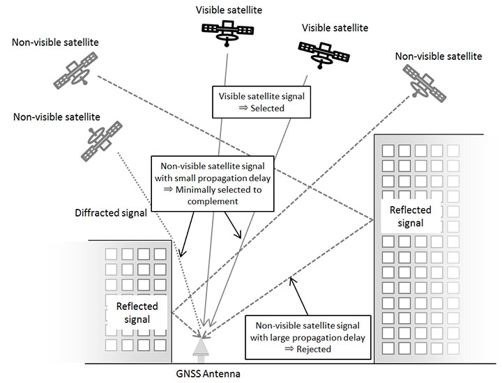
The GF-88’s new algorithm makes use of multipath signals, those reflected or diffracted from buildings and other structures, which previously inhibited accuracy of time synchronization.
By integrating a new satellite signal selection algorithm developed by NTT into Furuno’s time synchronization GNSS receiver, in addition to signals from satellites in line-of-sight locations, multipath signals can be used to reduce time error, the companies said.
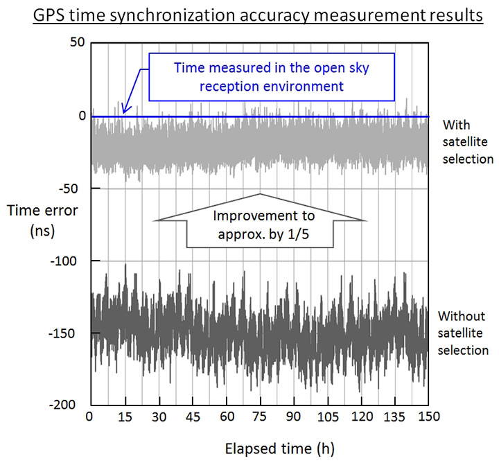
In a real multipath reception test environment, time error was reduced to approximately one fifth of earlier values.
The remarkable result promises to enable time synchronization accuracy close to that obtained in open-sky reception environments with no obstructions, even in environments previously considered poor and unsuitable for accurate time synchronization, such as among buildings or in mountainous areas.
The companies will exhibit the results at Tsukuba Forum 2018 Oct. 25-26, and at ITSF 2018, in Bucharest, Romania, Nov. 5-8.
Skycatch has announced an on-premise data processing and GNSS base station, the Skycatch Edge1, manufactured in partnership with DJI and now available worldwide.
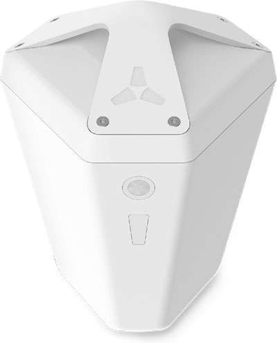
Edge1 base station. (Photo: Skycatch)
Tested and optimized for the Skycatch Explore1 and DJI Phantom 4 RTK drones, the self-positioning Edge1 allows commercial drone users the ability to process and receive data without the need for internet or cellular connectivity, the company said.
Field teams can fly their drone, process the data and receive centimeter-level data outputs in 30 minutes or less, directly to a tablet. 2D maps and 3D point clouds are available for viewing and sharing directly from the tablet.
The Edge1 concept began as a companion to the Skycatch Explore 1 drone. Now, a new generation of the Edge1 will support all DJI drones, including the recently released DJI Phantom 4 RTK, and will process any 2D geotagged images.
In addition to a survey-grade GNSS base station, the Edge1 includes built-in WiFi, LTE, reliable sub-5-centimeter accuracy, and delivers high-quality data outputs, the company added. Built around a state-of-the-art compute module, the Edge1 is also capable of running deep learning algorithms to extract more insights from collected data in near real time.
“It’s truly a revolutionary product that we’re excited to make available to the DJI community, and the construction and mining industry at large,” said Christian Sanz, founder & CEO of Skycatch. “With the partnership and support of DJI, the Edge1 will be assembled with precision execution in their world-class manufacturing facility, and will be available faster to the customer.”
“As the commercial drone industry has grown, the amount of data collected by our enterprise users is unprecedented,” said Jan Gasparic, director of strategic partnerships at DJI. “We are glad to work with Skycatch to manufacture the Skycatch Edge1 GNSS base receiver, enabling enterprise customers, especially those in the construction industry, to process data from their DJI drones on-site and in real-time.”
Skycatch is an industrial data collection and analytics company focused on indexing and extracting critical information from the physical world, using a combination of hardware, software and artificial intelligence. Built for enterprise, its turnkey solutions are deployed across global project sites with largest construction, mining and energy companies.
The Federal Aviation Administration (FAA) has issued more drone flight restrictions — this time, near U.S. Navy and U.S. Coast Guard vessels operating in the vicinity of Naval Base Kitsap, Washington, and Naval Submarine Base Kings Bay, Georgia.
Drone operations are required to maintain a distance of at least 3,000 feet laterally and 1,000 feet vertically from the ships and submarines.
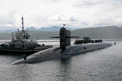
The Ohio-class ballistic-missile submarine USS Nebraska returns to Naval Base Kitsap-Bangor following sea trials. (Photo: U.S. Navy/Lt.Cmdr. Michael Smith, Commander, Submarine Group Nine)
At the request of the Department of Defense (DOD) and the United States Coast Guard (USCG), the FAA is using its existing authority under Title 14 of the Code of Federal Regulations § 99.7 — “Special Security Instructions” — to address concerns about potentially malicious drone operations over certain, high-priority maritime operations.
The special security instructions, provided in an FAA Notice to Airmen (NOTAM), are now in effect. Additional information on these special security instructions includes a visual depiction and geospatial definition of the relevant airspace.
The FAA also warns drone operators that the USN and USCG vessels are authorized by law to take protective action against drones perceived to be safety or security threats, which could result in seizure, damage or destruction of the drones.
Operators who don’t comply may face civil penalties and criminal charges.
Any operator with an overriding reason of public interest or necessity (such as conducting a search-and-rescue mission) to operate their drone in close proximity to the cited USN and USCG vessels must first coordinate with the USN or USCG point of contact.
In a separate Special Notice Advisory NOTAM, also effective today, the FAA strongly advises drone operators to remain clear of DOD and Department of Energy (DOE) facilities and mobile assets, as well as USCG vessels.
The notice applies nationwide and alerts operators who ignore this caution and conduct drone flights perceived to be a safety or security threat to these facilities and mobile assets could face a reaction by security forces that results in the interference, disruption, seizure, damage or destruction of their drone.
Information can be found here on these two NOTAMs, and all of the locations currently covered by § 99.7 restrictions. This website also provides an interactive map, downloadable geospatial data, and other important details. Additional information, including frequently asked questions, is available on the FAA’s UAS website.
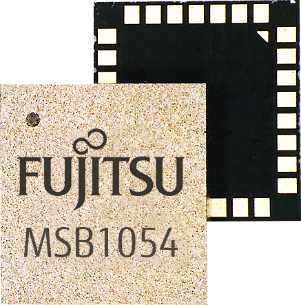
Fujitsu has introduced a low-power multi-GNSS module for consumer devices and asset tracking. (Graphic: Fujitsu)
The MSB1054 multi-receiver module requires no external components and has built-in Flash memory, meeting needs of smartwatches, fitness trackers, logistics and navigation.
Fujitsu Electronics Europe (FEEU) is expanding its ultra-low power portfolio to include a multi-receiver GNSS module: the MSB1054. The ability to receive signals from several satellite systems significantly reduces the time to first fix, providing for faster and more accurate positioning, the company said.
Photo: Fujitsu
Besides the GNSS device itself, the MSB1054 provides a built-in RF-front end (SAW filter, low-noise amplifier) as well as a temperature compensated crystal oscillator (TCXO), so with the exception of an antenna no external component is required.
Furthermore, Fujitsu’s GNSS module is equipped with a built-in Flash memory for quick “hot start” to save the navigation data and further optimize performance.
With its dimensions of 5.8×6.2×1 millimeters and 3.4 mA current in low-power mode (such as for tracking), the MSB1054 is designed for a variety of applications such as smartwatches, fitness trackers and asset tracking, and can navigate indoors or outdoors, the company added.
New connected-car automotive microcontroller (MCU) enables secure remote updates and high-speed in-vehicle networking.
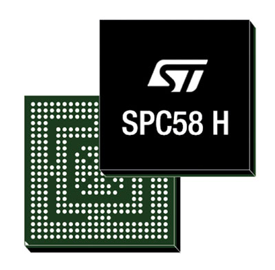
Image: STMicroelectronic
STMicroelectronics (ST) has launched a new flagship SPC58 H Line as part of its Chorus series of automotive microcontrollers (MCUs).
The new line can run multiple applications concurrently to allow more flexible and cost-effective vehicle electronics architectures.
The SPC58 H line has three high-performance processor cores, more than 1.2MB RAM and powerful on-chip peripherals, the company said.
As critical vehicle powertrain, body, chassis and infotainment features increasingly become defined by software, securely delivering updates such as fixes and option packs over the air (OTA) enhances cost efficiency and customer convenience, the company said.
With high security and large on-chip code storage, ST’s Chorus automotive microcontroller is a gateway/domain-controller chip capable of handling major OTA updates securely.
Two independent Ethernet ports provide high-speed connectivity between multiple Chorus chips throughout the vehicle and enable responsive in-vehicle diagnostics. Also featuring 16 CAN-FD and 24 LINFlex interfaces, Chorus can act as a gateway for multiple ECUs (electronic control units) and support smart-gateway functionality via 2 Ethernet interfaces also on-chip.
“The way carmakers create, configure, deploy and maintain new vehicles is changing, as software-defined functionality makes advanced features, flexibility and convenience ever more widely accessible,” said Luca Rodeschini, microcontroller business unit director at STMicroelectronics. “Our latest and highest-performing Chorus microcontroller, being OTA-ready and with dual Ethernet ports up to Gigabit speeds, creates a state-of-the-art platform for seamless, safe and secure in-car connectivity and control.”
To protect connected-car functionalities and allow OTA updates to be applied safely, the new Chorus chip contains a Hardware Security Module capable of asymmetric cryptography. Being EVITA Full compliant, it implements industry-leading attack prevention, detection and containment techniques.
Some customers have received samples of the SPC58 Chorus H Line microcontrollers in the next generation of smart gateways and central body modules, and are also evaluating the devices for battery-management units and ADAS safety controllers.
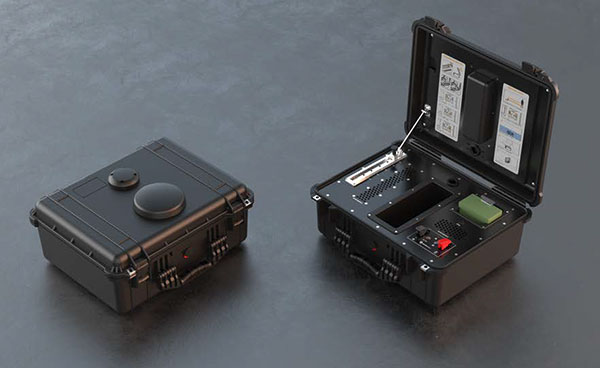
DroneShield has launched DroneNode in response to end-user requirements.
DroneNode is an evolution of the company’s DroneCannon product. It is a portable, compact and inconspicuous counter-drone jamming device that law enforcement can use at large outdoor events without raising public concern.
DroneNode comes in a portable case approximately 50 x 50 centimeters square. It can be set up in seconds and requires very little training to operate, the company said.
It can simultaneously jam 2.4 GHz, 5.8 GHz and GNSS L1 and L2 bands up to one kilometer, causing drones to return to their point of origin or land. DroneNode is also effective against swarm attacks. Emergency broadcasts, cellphone communication and other dedicated channels will not be affected.
According to the company, DroneNode’s covert design makes it a suitable counter-drone solution for public events where protection from drone threats is a priority. Designed within a rugged carry case, DroneNode is easy to transport and is protected from the elements.
DroneNode is powered by a NATO-approved self contained battery with room for a second battery stored in the accessories tray.
“The release of DroneNode continues DroneShield’s leadership in drone security for public events,” said Oleg Vornik, DroneShield’s CEO. “DroneShield’s recent credentials in the area include the 2018 Olympics, the 2018 Commonwealth Games, 2018 ASEAN-Australia Special Summit, the 2017 Hawaii Ironman World Championship, and the 2015 to 2017 Boston Marathons. The company’s products are well positioned to protect large public gatherings globally.”
According to DroneShield, the product is particularly relevant given the recent drone attack on the Venezuelan president and the high-profile mail bomb terrorist attacks in the United States, heightening the awareness of law enforcement globally to potential threats to high-profile political targets.
A Venezuela soldier received head injuries in a the drone attack against the president. (Photo: Released by Xinhua News Agency)
FCC Authorization Pending. DroneNode and DroneCannon have not been authorized as required by the U.S. Federal Communications Commission (FCC). The devices are not, and may not be, offered for sale or lease, or sold or leased, in the United States, other than to the U.S. government and its agencies, until authorization is obtained.
The use of such devices in the United States by other persons or entities, including state or local government agencies, is prohibited by federal law. Laws limiting the availability of such devices of certain types of users may apply in other jurisdictions, and any sales will be conducted only in compliance with the applicable laws.
Kespry and DJI are partnering to offer the DJI Mavic 2 Pro drone as part of the Kespry stockpile measurement solution for mining and aggregates companies.
The solution delivers the Kespry autonomous flight and aerial intelligence experience for stockpile measurement using a DJI drone. It enables large aggregates and mining companies to standardize and capture stockpile data across all their sites in the Kespry platform, while continuing to use Kespry 2s drones to support mine and site planning operations, Kespry said.
Integration of data captured from a DJI drone is the next innovation in the development of the Kespry industrial sensor platform.
Kespry provides inventory management and mine planning data to more than 200 mining and aggregates companies. As these customers scale their use of drone data, they are looking to standardize on a single platform to organize and analyze that data across sites, geographies and product divisions — even when those sites are highly distributed, Kespry said.
The addition of the DJI Mavic 2 Pro to the Kespry lineup is designed to enable even more site data to be centralized in the Kespry cloud. It will be available with a new, cost-effective purchase point designed to support using Kespry across more sites.
“Drone data is now the standard approach for measuring stockpiles at mine sites, however, millions of dollars are wasted through reconciling inconsistent data from different platforms and the time involved getting that data ready for analysis,” said George Mathew, CEO and chairman at Kespry. “Our goal with the addition of the Mavic 2 Pro to our solution is to respond to our customers wishing to use the Kespry aerial intelligence platform across all mine sites to standardize how stockpile data is generated — lowering their costs and helping drive the profitability of every site.”
“DJI is excited to have Kespry offering the Mavic 2 Pro as part of its aerial intelligence platform portfolio,” said Jan Gasparic, director of strategic partnerships, DJI. “Pairing the Mavic 2 Pro with Kespry’s industry leading AI, ML, and analytics capabilities will be of enormous benefit to mining companies that are looking to take advantage of drone technology in a portable and powerful package.”
According to the companies, the integration of DJI’s drone and sensors into the Kespry platform is the latest innovation in the delivery of an industrial sensor network, closely following Kespry’s recently announced high-resolution thermal capabilities for industrial inspection.
This expansion in the range of data that can be explored and analyzed in the Kespry platform further enables customers to protect and maximize their assets across industrial sites.
The Kespry platform is now capable of processing and analyzing a wide range of sensor data, enabling the future creation of industry-specific applications, including those under current development with leaders in the energy sector.
“We have sites in North Carolina, Pennsylvania, Ohio and Maryland, so with the Kespry platform and DJI drone, we’ll be able to fly multiple sites at one time,” said Justin Dermont, accounting manager at Russell Standard. “I could be flying in Erie while my partners fly in North Carolina, but still be able to get the data in real time to the Kespry cloud.”
“Having DJI as part of the Kespry system will help with the flexibility and the timeliness of us being able to take inventory at multiple locations, especially when we have to take inventory at the end of production, or month end, to make sure we have accurate readings,” said Craig Schiebel, controller at Russell Standard. “Being able to take inventory simultaneously at multiple locations is huge.”
“We’re growing our business and recently acquired some new sites,” said Kyla Jungclaus, senior accountant at Brannan Companies. “We need all of our inventory to be done in just a couple days, so introducing the DJI drone to have another pilot surveying at some of our other locations will get inventory done even faster. I know that our measurements will be consistent and accurate even if I don’t do them myself, and I can manage them all in a single account in the Kespry cloud.”
Kespry is offering the Mavic 2 Pro as part of its fully-managed, end-to-end annual subscription model. Kespry customers that choose the Mavic 2 Pro for stockpile measurement will benefit from the full Kespry experience, including its acclaimed support, training, customer success team, and drone up-time guarantee.
The Kespry stockpile measurement solution with DJI will be available Q1 2019.
Propeller Aero, a cloud-based drone analytics company, is partnering with DJI to create the Propeller PPK Solution leveraging the DJI Phantom 4 RTK drone.
The solution provides customers in the civil, mining, aggregates and waste management industries with a reliable and fully integrated drone mapping system, helping them collect highly accurate data from any worksite without the challenges of traditional workflows, the companies said.
The DJI Phantom 4 gathers data at a construction site. (Photo: DJI)
According to Propeller Aero, Propeller PPK Solution is a fully integrated software and hardware system that reliably provides photogrammetric model outputs in geodetic, projected or local coordinate systems.
The solution provides accuracy of 1/10 feet (3 cm) from independent checkpoints across small and large survey areas (checkpoints up to 1 km from GCPs). To capture surveys of this accuracy, all that is needed is one AeroPoint on the ground (over a known point if working in local coordinates).
The Propeller PPK Solution has been shown to reduce the time required to complete a drone survey by 70 percent as compared to a traditional workflow using multiple GCPs across a worksite, Propeller Aero said.
“DJI has led the drone market with their reliable and innovative products, and quickly demonstrated the ability for these machines to become useful tools in the heavy civil and natural resource industries,” said Rory San Miguel, CEO of Propeller Aero. “Globally, these industries are seeing real cost savings and efficiencies through cloud-based analytics and using innovative new technologies like PPK drones combined with AeroPoints. Accurate data is paramount to worksite analytics and Propeller has always been obsessed with helping teams achieve this. We introduced the world’s first smart ground control point, AeroPoints, and now we’ve partnered up with DJI to build an end-to-end PPK solution.”
On today’s construction sites, lack of project data costs businesses more than $177 billion annually. To help solve this problem, Propeller developed a tightly integrated PPK workflow across the DJI Phantom 4 RTK drone, an AeroPoint, and Propeller’s cloud processing platform that visualizes real-time site data. Surveyors and contractors can Propeller PPK solution to gather verifiable, trustworthy data to help make data-driven decisions and prevent costly mistakes, the companies added.
“Propeller’s deep expertise in aerial mapping and analytics coupled with DJI’s industry-leading open-platform drone hardware creates a highly accurate turnkey solution,” said Jan Gasparic, director of strategic partnerships at DJI. “We are excited about this partnership because it broadens the use of DJI drones to deliver accurate data at a cost-efficient price point, helping teams better answer questions about site progress and productivity.”
The complete PPK solution will be distributed through channel partners, including Trimble’s SITECH distribution network. Trimble Stratus, a 3D cloud-based visualization platform developed by Propeller, along with AeroPoints, is already integrated with Trimble Connected Site solutions.
“The advent of drones in the construction industry has improved efficiencies, and Trimble Stratus users are already benefiting from the ease-of-use and scalability of drone-based surveys,” said Scott Crozier, general manager, Trimble Civil Engineering and Construction. “With the new Propeller PPK Solution and Trimble Stratus software, we’ve seen first-hand how surveyors and contractors can collect aerial survey data in a fraction of the time it used to take, and get repeatable and reliable results.”
Karamba Security, a provider of automotive cybersecurity, and STMicroelectronics (ST), a global semiconductor company, are integrating Karamba’s Carwall end-to-end protection on the ST Telemaco3P STA1385 Automotive Telematics and Connectivity Processor.
Together, ST and Karamba are leveraging the security architecture of the Telemaco3P with the addition of Carwall Electronic Control Unit (ECU) hardening software.
The combined solution provides cyber security features for both contents and run-time integrity verification by detecting attempts at modifications and preventing deviations from the ECU’s intended behavior, the companies said.
Karamba Security’s deterministic approach has shown to prevent vehicle cyberattacks with zero false positives.
“STMicroelectronics is a leading provider in the connected-car ecosystem,” said Ami Dotan, Karamba Security’s co-founder and CEO. “We are pleased to collaborate to protect automotive systems based on ST’s Telemaco3P microprocessor by automatically hardening them against cyberattacks to assure consumer safety.”
“Karamba Security’s differentiated cyber-prevention solutions have generated significant market traction in a very short time and are a strong fit to enhance the security and value of ST’s Telemaco3P architectures,” said Antonio Radaelli, director of STMicroelectronics’ Infotainment, Automotive Digital Division. “Karamba’s Carwall adds another layer of security to the Telemaco3P benefits, which include its state-of-the-art power-efficient design, fast connectivity interfaces, domain isolation, and embedded Hardware Security Module. The combination provides customers with even stronger cybersecurity protection for in-vehicle systems.”
For more information, visit STMicroelectronics’ booth at Electronica Munich on Nov. 13-16 in C3 Stand 101, where ST and Karamba will be available to discuss this joint security solution.
SmartDrive Systems, a video-based safety and transportation intelligence company, is collaborating with Geotab to provide fleets with integrated solutions that leverage the SmartDrive platform as a single on-board data collection hub.
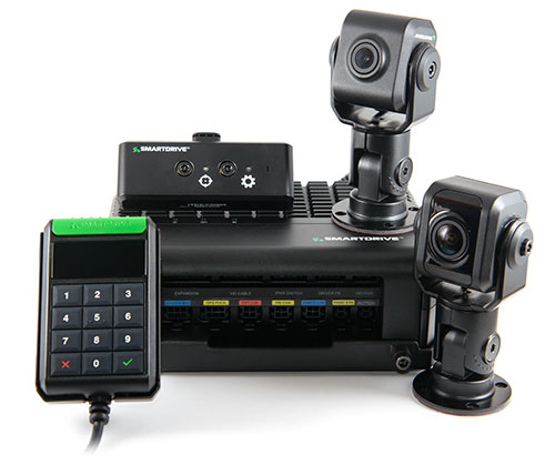
The SmartDrive SR4 video hardware platform. (Photo: SmartDrive Systems)
SmartDrive and Geotab are helping to simplify the on-board technology footprint, providing fleets the freedom to choose solutions that fit their business and their budget, and dramatically lowering the total cost of ownership.
SmartDrive offers a single integrated and aligned understanding of time, location and driver and vehicle performance to third-party applications. Fleets will be able to select solutions without incurring the additional costs associated with managing and maintaining multiple onboard devices.
“The ability to integrate and operate applications from a single data collection platform breaks through significant technology and operational barriers — unlocking efficiency gains for fleets across routes, drivers and risk,” said Steve Mitgang, SmartDrive CEO. “Collaborating with Geotab allows us to make good on the promise of convergence with a company that shares our commitment to providing open, connected and flexible solutions for fleets of every size. We believe this is a transformational shift — and it’s only the beginning of what is possible for our customers.”
With the growth of technology in the cab, fleets are struggling with how to manage the number of devices on the windshield and the connection of those devices in the vehicle.
Video-based safety cameras, electronic logging devices and advanced driver assist system (ADAS) sensors are causing fleets to look for integrated solutions that solve the hardware and data overload problem. Beyond the number of devices on the vehicle, fleets also are contending with the cost to install, maintain and train on each of these technologies. With the migration from 3G cellular networks to 4G, and resulting need to upgrade onboard hardware, fleets have an opportunity to re-think and streamline their technology strategy.
“For too long, traditional telematics systems have saddled fleets like ours with costly hardware that is expensive to maintain and upgrade, and monthly subscription costs that continue to escalate,” said Matt Penland, vice president of safety, Cypress Truck Lines. “There has to be a better way. Fleets should have the same freedom and flexibility to consolidate devices and applications that we all now have on our cell phones. The technology is available to make this possible.”
The SmartDrive platform provides a unified video and telematics data stream that can be leveraged by third parties to power their applications, the companies said. This same data stream powers the SmartDrive video safety program, ADAS and transportation analytics applications.
Through the collaboration, Geotab telematics and compliance offerings take advantage of the SmartDrive single box architecture and unified data stream, eliminating redundancy across hardware, cellular connectivity, GPS modules, connections to the ECU and cabling. It also provides data alignment across the two providers’ applications, unlocking new fleet performance insights and eliminating problematic data discrepancies.
As a result of the collaboration, fleets can benefit from:
The SmartDrive video safety program
SmartDrive SR3 or SR4 video hardware platform
“Single box” architecture enabling the convergence of data, devices and network connectivity
Analytics powered by SmartDrive SmartIQ
Geotab tracking, which delivers real-time and historical visibility to location, speed and geofencing information
Geotab regulatory compliance, including hours of service, driver vehicle inspection reports, International Fuel Tax Agreement (IFTA) recording and tax reports
Access and integration to Geotab Marketplace partners.
“Geotab’s open platform centers on a reliable, scalable and secure approach to data access for business solutions,” said Colin Sutherland, executive vice president of sales, Geotab. “We have always said that our hardware is agnostic. The SmartDrive video hardware integration is a solution that not only leverages Geotab’s platform strength to incorporate data from non-Geotab hardware, but it is a great example of telematics solutions that extend the capital investments across multiple solution providers.”
With more than three billion data points collected daily from over one million vehicles, Geotab helps companies access critical business intelligence and benchmarking data to help increase productivity, reduce fuel consumption, improve driver safety and strengthen compliance.
The integration with Geotab will be generally available early in the first quarter 2019, and the SmartDrive convergence early adopter program is in progress.
Current and prospective customers will be able to take advantage of the integration to Geotab from either the SmartDrive SR3 or SR4 platform.
Released in March 2018, the new SR4 hardware includes unprecedented compute power in a small, flexible footprint; new sensors for advanced risk identification and real-time driver-assist; innovative architecture enabling the convergence of data, devices and network connectivity; new analytics powered by SmartDrive SmartIQ; and a video safety program.
Cohda Wireless has successfully demonstrated its connected autonomous vehicle technology in a live trial on the streets of the city of Adelaide, Australia.
The trial proved the potential for connected self-driven vehicles to make streets safer and that Cohda’s technology is effective even in challenging urban canyons.
In an area covering two city blocks east of Adelaide’s Victoria Square, the demonstration replicated a scenario that is a daily occurrence on the streets of cities all over the world.
In the scenario, two vehicles approach a four-way intersection at right angles to each other. Car 2, driven by a human, fails to adhere to the red-light signal and approaches the intersection at speed, intending to “skip” the red light. Car 1, a connected autonomous vehicle, is approaching the intersection from another direction and intends to proceed through the intersection on the green light.
In a real-life scenario, there would be a risk of a collision as human drivers will invariably approach the intersection when the light is green, fully confident that all other road users will obey the traffic signals. In an instance where Car 2 disobeyed the traffic signal and Car 1 was unable to see the approaching danger, due to visibility being obstructed by buildings or other infrastructure, a collision would be especially likely.
But as Cohda Wireless’s Chief Technical Officer Professor Paul Alexander explained, if the vehicles were connected using Cohda’s V2X (Vehicle-To-Everything) technology, a potential collision situation would be detected and avoided well in advance of it actually happening.
“We demonstrated that when vehicles are connected to each other using our smart V2X technology, Car 1, the connected autonomous vehicle, would detect that Car 2 is approaching the red light at speed and is probably not going to stop. This allows the connected autonomous vehicle to pre-emptively identify and respond to the threat by slowing down and stopping.”
“Cohda’s V2X technology allows vehicles to ‘speak to each other’ to extend their perception horizon,” added Alexander.
“The technology provides the vehicle with an awareness of its environment and risk factors associated with it, consistently and accurately up to ten times per second, enabling it to make decisions that a human being would not be capable of making as the driver of the vehicle.”
Cohda’s Smart Cars Smart City initiative was funded by the South Australian Department of Transport and Infrastructure’s Future Mobility Lab Fund. In June this year, Cohda Wireless took ownership of two specially-modified vehicles from the U.S. that it is using in advanced trials of its V2X (Vehicle-To-Everything) technology.
The two Lincoln MKZ sedans were fitted with the ADAS (Advanced Driver Assistance Systems), ROS (Robot Operating System) various sensors including lidar, radar, cameras, GPS as well as in-vehicle compute platform and Cohda’s GNSS- independent positioning technology.
The fusion and cooperation of the various sensors and Cohda’s V2X technology augment the vehicles’ perception capability and make the autonomous vehicles features more practical, to include threat detection, the dangers associated with blind intersections and vulnerable road users, the company said.
“Our goal today was not only to demonstrate the efficacy of our technology in enabling self-driven vehicles to communicate with each other, but also to do so in a city environment where so-called ‘urban canyons’ significantly affect the ability of systems reliant on Global Navigation Satellite Systems (GNSS) to achieve accurate positioning,” Alexander said.
“The area in the city of Adelaide in which the trial was conducted was one such urban canyon where positioning through GNSS can be off by up to 40 meters, but with our V2X Locate technology positioning accuracy is improved to within a meter.”
Photo: Cohda Wireless
Cohda Wireless demonstrated the efficacy and accuracy of its V2X-Locate system in a 2017 trial in New York City where it repeatedly demonstrated sub-meter accuracy while driving along Sixth Avenue, which has the tallest buildings in the Big Apple. Comparably tested GPS-based systems were as much as tens of meters off-course, at times showing cars driving through buildings.
Cohda’s V2X technology underpins and complements other technology used by autonomous vehicles such as cameras, sensors, radars and lidars by enabling cooperative perception.
“The role of technology in making our roads safer is probably not generally understood but we hope that this demonstration has helped to prove that with the appropriate technology and infrastructure, connected self-driving vehicles are safer to have on our roads than vehicles controlled entirely by human beings,” added Alexander.