Israel-based Autotalks has launched what it calls a global V2X (vehicle-to-everything) chipset.
The chipset supports both dedicated short-range communications (DSRC) and cellular vehicle-to-everything (C-V2X) technology — both allow vehicles to share their location and speed to help prevent accidents and improve the safety of autonomous driving systems, the company said.
The chipset’s processor also could allow customers to switch between the two standards. It minimizes development, testing and certification efforts for a V2X system to be deployed anywhere via a software-defined toggle between the two V2X technologies.
Two competing standards
Automakers have announced intentions to equip their new car models with V2X technology. In recent years, V2X has diverged into two different solutions, DSRC and C-V2X.
While DSRC-based V2X is deployed in the U.S., Europe and Japan, C-V2X is gaining momentum in other regions. Its fundamentally different architectures have made it difficult to harmonize a single global solution.
Autotalks’ response is to equip its second-generation chipsets with C-V2X in addition to native support of DSRC.
Autotalks’ deployment-ready, second-generation V2X chipset supports both DSRC and C-V2X direct communications (PC5 protocol) at the highest security level. According to the company, the chipset supports DSRC based on 802.11p/ITS-G5 standards and C-V2X based on 3GPP specifications.
Autotalks said its chipsets were designed to meet V2X market requirements and standards, including security, environmental, quality, thermal and other requirements.
The U.S. Federal Communications Commission will vote in November on whether to allow U.S. devices to access Galileo.
The Galileo Order is tentatively on the agenda for the Open Commission Meeting scheduled for Thursday, Nov. 15:
Galileo Order – The Commission will consider an Order that addresses waivers of certain satellite licensing requirements for receive-only earth stations operating with the Galileo Radionavigation-Satellite Service. (IB Docket No. 17-16)
“Enabling the Galileo system to work in concert with the U.S. GPS constellation should make GPS more precise, reliable and resilient for American consumers and businesses alike ,” said FCC Chairman Ajit Pai.
In 2015, the National Telecommunications and Information Administration (NTIA) submitted to the FCC a request from the European Commission to waive certain of the commission’s earth station licensing rules to permit non-federal U.S. receive-only earth stations to operate with Galileo.
The NTIA recommended grant of the requested waivers, and the International Bureau issued a Public Notice seeking comment on the potential public interest benefits and technical issues associated with the waiver request.
The FCC is proposing to waive its licensing requirements for non-federal operations with Galileo signals known as E1 and E5, subject to certain technical constraints, officials said.
The FCC includes conditions to ensure users of satellite-based positioning, navigation and timing services in the United States will benefit from Galileo signals. The systems are interoperable under a 2004 agreement.
Below is a summary of the order; the full text can be downloaded here.
Grant in part the request of the European Commission for waivers of certain of the Commission’s earth station licensing rules to permit non-federal U.S. receive-only earth stations to operate with specific signals of the Galileo GNSS without obtaining a license or grant of market access.
Find that the Galileo GNSS is uniquely situated as a foreign GNSS system with respect to the U.S. GPS, since the two systems are interoperable and radiofrequency compatible pursuant to the 2004 European Union/United States Galileo-GPS Agreement.
Find that there are significant public interest benefits associated with operations of non-federal U.S. receive-only earth stations with the Galileo GNSS, including increased availability, reliability, and resiliency of position, navigation, and timing services in the United States.
Grant the request for operations with the Galileo E1 signal, which is transmitted over the 1559-1591 MHz frequency band.
Grant the request, and a waiver of the non-federal portion of the U.S. Table of Frequency Allocations, for operations with the Galileo E5 signal, which is transmitted over the 1164-1219 MHz frequency band.
Deny the request for operations with the Galileo E6 signal, which is transmitted over the 1260-1300 MHz frequency band, since there is no federal or non-federal allocation for RNSS in the U.S. Table of Frequency Allocations in that band and grant of waiver could constrain our future spectrum management for non-federal operations in the U.S. in spectrum above 1300 MHz, where potential changes in the non-federal allocation are under consideration.
The base of the channel was just wide enough (12 feet) to fit the John Deere machine for grading the 2:1 slope. With GNSS, the operator did not have to reference grade stakes or stop for grade checks. (Photo: Topcon)
Noel Guevara, president and owner of JAG Construction, considers it an honor to have been involved in a project to expand the National Memorial Cemetery of Arizona.
To get the job done as quickly and efficiently as possible, the fledgling company drew upon GNSS technology for the bulk of its grading and specialized excavation needs.
Doing so, it was able to wrap up the major expansion on time, with as little disruption as possible.
Additional Space Needed. The cemetery expansion will help alleviate a shortage of burial space brought about by the passing of veterans of World War II, the Korean Conflict and the Vietnam War.
The project involves development of 22 acres adjacent to the existing cemetery including construction of two columbarium courts to house 4,688 niches for cremains; 2,180 pre-placed crypts; grading for 1,900 in-ground cremains; 650 linear feet of roadway; two retention ponds; and 1,350 feet of shotcrete drainage channel.
A look around the expansion site — previously scrub land — revealed few grade stakes, a sign that GNSS technology was at work. “I first used GPS when I was with a company back in 2000,” Guevara said. “So I know the tremendous boost in productivity it can give, and felt that I had to have it on this project.”
Critical Support. While Guevara may have felt at home with machine control, some of his team needed a crash course in working within a GNSS environment. RDO Integrated Controls outfitted JAG’s two motor graders with Topcon 3D-MC2 machine control in a twin-antenna, single-mast configuration.
Guevara’s decision to place his faith in the GNSS solution put his company at what Topcon calls the “intersection of infrastructure and technology,” a conceptual crossroads where Topcon helps industry professionals best meet growing infrastructure demands through technological innovation — increasing both productivity and profitability.
A Channel Runs Through It. Though the majority of the cemetery expansion site is relatively flat, the retention ponds and drainage channel could have proven problematic, had they been done using traditional survey methods.
Guevara said being able to do the detail work with the Topcon system dramatically ramped up production.
“This is easily 70% faster than doing things old-school,” he said. “Having the blades equipped with GPS gave us the confidence to walk away each day knowing that the numbers were there.”
JAG was also contracted to excavate foundations for a pair of columbarium courts. Guevara once again turned to GNSS to streamline that effort, specifically a dual-antenna Topcon MC-i3 system with a GX-55 control box.
“Because of the GPS system on that machine, the operator knew exactly how far down he had to go; there was no questioning or verifying depths — that was a nice solution for us.”
In 2017, JAG invested in six GNSS-based machine control systems. This year they are looking at additional machine purchases to meet what is forecast to be more than double 2017’s numbers.
New risk-based “bow-tie” zones will help protect aircraft using PrecisionHawk’s Low Altitude Traffic and Airspace Safety (LATAS) platform.
DJI is improving its geofencing technology to refine the airspace limitations for drone flights near airports, providing smarter protection for airplanes in critical areas.
DJI has updated Geospatial Environment Online (GEO) Version 2.0, and will phase it in starting in November when the revised zones will take effect for airspace around airports in the United States. Upgrades in other regions will follow.
Image: DJI
The new system allows GEO to create detailed three-dimensional “bow-tie” safety zones surrounding runway flight paths, and to use complex polygon shapes around other sensitive facilities, rather than simple circles.
The new restrictions better reflect the actual safety risk posed in those areas, while allowing more flights to the side of runways where risk is substantially lower.
Runway exclusion zones. DJI’s new geofencing also incorporates the principles of Section 384 of the recently enacted U.S. Federal Aviation Administration (FAA) Reauthorization Act designating the final approach corridor to active runways at major airports to be “runway exclusion zones” for unauthorized drones. DJI customers should update their DJI GO 4 flight control app and aircraft firmware to ensure these improvements are implemented.
To obtain reliable geospatial information for the enhanced shapes in GEO 2.0, DJI has chosen a new data provider that can provide highly accurate details such as the exact locations of airport runways and facility boundaries.
PrecisionHawk’s LATAS. In North America, DJI will use data from PrecisionHawk Inc., replacing DJI’s previous geospatial data provider AirMap. Under a partnership agreement, PrecisionHawk’s Low Altitude Traffic and Airspace Safety (LATAS) platform will provide DJI customers with critical airspace information that will position them to fly safely in North America.
DJI will be able to refine airspace limitations for drone flights near airports, providing smarter protection for drones in critical areas and clarifying restrictions, PrecisionHawk said.
“PrecisionHawk has a corporate commitment to safely integrating drones into the airspace and enabling complex operations,” said Diana Cooper, senior vice president of policy and strategy at PrecisionHawk. “Through our work under the FAA Pathfinder Program, we have shown how technology can play a critical role in unlocking advanced operations, including beyond visual line of sight flight.”
GEO 2.0 Development. DJI first created No-Fly Zones for its drones in 2013 and introduced the more refined GEO system three years later, adding live updates and new zones for prisons and nuclear power plants, while providing flexible self-unlocking for professionals.
Both systems recognized that the overwhelming majority of drone pilots want to fly safely and responsibly, and want an easy-to-use guide to help them understand the airspace so they can do so.
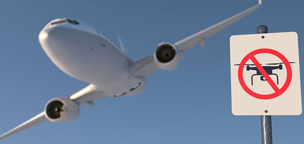
Artist’s rendering of a no-drone sign near an airport. Image: PixOne/Shutterstock.com
To develop GEO 2.0, DJI collaborated with general aviation pilots through the Aircraft Owners and Pilots Association (AOPA) and with airports through the American Association of Airport Executives (AAAE) to incorporate their expertise and guidance about air traffic and airports into DJI’s new geofencing methods.
DJI geofencing uses GPS and other navigational satellite signals to automatically help prevent drones from flying near sensitive locations such as airports, prisons, nuclear power plants and high-profile events.
In certain locations, a DJI drone cannot take off or fly in a geofenced area without special authorization. Drone pilots with verified DJI accounts can unlock some areas if they have legitimate reasons and necessary approvals, but the most critical areas require special action from DJI to unlock them.
DJI has streamlined the approval process so professional drone pilots with authorization to fly in sensitive locations can receive unlocking codes within 30 minutes.
The GEO System. The GEO system previously geofenced a 5-mile circle around airports, with enhanced restrictions in a smaller circle encompassing the airport area.
GEO 2.0 applies the strongest restrictions to a 1.2 kilometer- (3/4 mile)-wide rectangle around each runway and the flight paths at either end, where airplanes actually ascend and descend. Less strict restrictions apply to an oval area within 6 kilometers (3.7 miles) of each runway.
This bow-tie shape opens more areas on the sides of runways to beneficial drone uses, as well as low-altitude areas more than 3 kilometers (1.9 miles) from the end of a runway, while increasing protection in the locations where traditional aircraft actually fly.
Artist’s concept of a drone approaching a commercial airliner. Image: PixOne/Shutterstock.com
Aviation Parameters. DJI’s new boundary areas around airport runways are based on the International Civil Aviation Organization’s Annex 14 standard for airspace safety near runways and the FAA’s Part 77 parameters for “imaginary surfaces” and air navigation obstructions.
DJI’s categorization of airports is based on traffic volume principles defined in statutes such as U.S. Title 49 section 47102, and the FAA’s criteria developed in 2012 for categorizing general aviation airports.
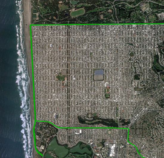
Using these aviation parameters, DJI has aligned its geofencing safety feature to broader understandings of airspace and airport risk. This chart demonstrates how GEO 2.0 applies those detailed, risk-based airspace boundaries to the airspace around airports that can be considered to involve relative high, medium, and low risk (see graphic).
LATAS. Through its work under the FAA Pathfinder Program, PrecisionHawk has shown how technology such as LATAS can play a critical role in unlocking advanced operations, including beyond visual line of sight flight. LATAS was tested under the Pathfinder Program to facilitate safe beyond visual line of sight operations.
LATAS brings a combined set of geospatial and software tools to the market. In addition to providing improved geospatial data, the LATAS platform features specialized display elements, including telemetry and access to the Harris real-time manned aircraft feed. Using these elements pilots can easily observe the relative altitude and horizontal separation of intruding aircraft and other mission-critical measures.
By Paolo Crosta, Paolo Zoccarato, Rafael Lucas and Gerarda De Pasquale, European Space Agency
Test set-up. (Image: Authors)
Most mass-market manufacturers have already developed a dual-frequency chip or will soon do so. What is still not completely clear is the main benefit of adding the second frequency. Is it beneficial just for correcting ionospheric error?
Will it provide an improvement of the ranging error thanks to the wideband nature of the signal broadcast on the second frequency and their multipath rejection capabilities? Is it improving the measurement quality by means of a higher transmitting power?
Could it be exploited as a source of data for the provision of accurate orbit and clock corrections? What is the best PVT algorithm to apply to a multi-constellation dual-frequency mass-market chip?
To answer these questions, an evaluation kit of the Broadcom chip BCM4775 has been tested — the first dual-frequency mass-market chip commercially available.
Results show:
the code noise (multipath) is often the main source of error, hiding the benefits of more accurate clocks and orbital data.
wide-band signals are very beneficial for multipath rejection. Position fix based on E5a-L5-only measurements even with fewer satellites can outperform L1-E1-only in tests performed this September (impact of the new Galileo satellites).
after deactivation of the duty-cycle tracking on Android phones, the carrier phase measurements are improved and we do not experience any longer filter resets in the position Kalman filter.
The mixed urban environment in San Francisco, where Starling + the TeseoAPP was tested and data collected and processed in real time. (Image: Swift Navigation)
The Starling modular and portable GNSS high-precision positioning engine leverages Swift’s Skylark Cloud Corrections Service. An advanced GNSS processing engine, Starling enhances measurements from commercially available GNSS receivers to provide true precision and integrity capabilities, the company said.
Starling is GNSS-receiver agnostic and works with a variety of automotive grade GNSS chipsets and inertial sensors, offering automotive companies choices in selecting the best components for their autonomous sensor suite, vehicle-to-vehicle (V2V) applications and automated driving systems.
In a test drive in California, Swift showcased the integration of Starling onto ST’s Telemaco3P MPU-based modular telematics platform with on-board TeseoAPP, confirming the accuracy of the combined solution as a compelling offering for safety-critical autonomous-vehicle positioning when ST makes production TeseoAPP chipsets available in 2019.
Skyworks Solutions‘ advanced wireless engines are enabling Philips’ CityTouch end-to-end street lighting management platforms.
Specifically, Skyworks’ connectivity solutions provide efficiency, extended range and complete network coverage to facilitate seamless communication between Philips’ smart street lamps and cellular base stations.
The innovative devices allow city operators to reduce power consumption and support public safety through adaptive scheduling and remote services, the company said. Installations of CityTouch have commenced worldwide, fostering more livable and sustainable environments.
Local governments are increasingly using internet of things (IoT) and artificial intelligence (AI) innovations to overcome fiscal, environmental, security and energy challenges. Skyworks’ robust portfolio of IoT architectures are empowering numerous applications for intelligent city operations spanning smart metering, surveillance systems and responsive traffic signals.
“Skyworks is playing an integral role in the transformation of cities into dynamic, automated ecosystems,” said Carlos Bori, vice president of sales and marketing for Skyworks. “In particular, our high-performance wireless solutions are facilitating highly efficient, long-range connectivity for IoT platforms. Looking ahead, as cities become even smarter with the convergence of diverse AI applications, Skyworks is delivering the enabling technologies that will usher in a new era of connected living.”
According to ABI Research, IoT technology revenues across 12 key smart city verticals are expected to grow from $25 billion in 2017 to $62 billion by 2026. This growth is being driven by a number of factors including the modernization of city infrastructure systems, increasing demand for intelligent, energy-saving street lighting and a growing awareness among consumers and governments worldwide.
In a 50-page report to the U.S. Senate Armed Services Committee, the government’s General Accounting Office (GAO) finds that U.S. weapons systems are, almost across the board, highly vulnerable to cyber-attack. Furthermore, the Department of Defense (DoD) has gotten off to “a late start” in prioritizing cybersecurity, and has only “a nascent understanding” of how to develop more protected weapons systems. The October 2018 report, “Weapons Systems Cybersecurity,” is subtitled “DoD Just Beginning to Grapple with Scale of Vulnerabilities.”
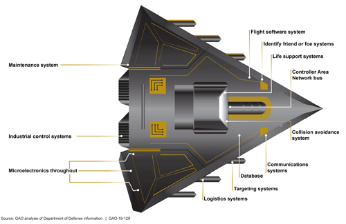
[Image above: Figure 2 from the GAO report: Embedded Software and Information Technology Systems Are Pervasive in Weapon Systems, represented via Fictitious Weapon System for Classification Reasons). Source: GAO analysis of Department of Defense information, GAO-19-128.]
GPS can figure to be among these threatened systems, and GPS guidance aboard many munitions and almost all platforms vastly expands the danger. The satnav system is not mentioned by name in the report (“To present information in an unclassified format, we do not disclose details regarding weapon system vulnerabilities, which program offices we interviewed, or which cybersecurity assessments we reviewed.”), and the word navigation surfaces only once, but it’s an alarming appearance:
“Weapon systems are dependent on external systems, such as positioning and navigation systems and command and control systems in order to carry out their missions—and their missions can be compromised by attacks on those other systems. A successful attack on one of the systems the weapon depends on can potentially limit the weapon’s effectiveness, prevent it from achieving its mission, or even cause physical damage and loss of life.”
The latter scenario could occur if a GPS-guided armament were hacked and rerouted to a civilian target, for example.
The GAO states that it warned as far back as 2015, and in repeated instances since that date, that federal and contractor systems face an evolving array of cyber-based threats, including criminals, hackers, adversarial nations, and terrorists. “Threats can range from relatively unskilled “script kiddies” who only use existing computer scripts or code to hack into computers, to well-resourced and highly skilled advanced threats who not only have sophisticated hacking skills, but also normally gather detailed knowledge of the systems they attack.”
Networks, Computers Increase Vulnerabilty
The increasingly computerized and networked nature of the U.S. military’s weapons contributes to their vulnerability. As weapon systems become more software- and IT-dependent and more networked, they actually become more vulnerable to cyber-invasion. Networks can be used as a pathway from one accessed weapon to attack other systems.
“Nevertheless,” the report adds, “until recently, DOD did not prioritize cybersecurity in weapon systems acquisitions. . . . DOD is in the early stage of trying to understand how to apply cybersecurity to weapon systems.”
As the GPS constellation — the satellites themselves as well as the ground control system — become more software-reliant, including the ability to modify signals by remote software command, this has to be a growing concern for the U.S. Air Force. Difficulties with cyber-proofing the next-generation ground control system, OCX, have been suspected as a leading cause of extended delivery delay in that program.
DoD officials reportedly confided that it will take time — and possibly some missteps — to learn what does and does not work in combatting cyber-attacks on weapon systems.
Separately, a UK defense expert consultant stated that Russia had “stolen a march on using cyber-capabilities at a tactical level on the battlefield.” As reported last year in GPS World, Black Sea spoofing incidents aroused suspicion that Russia was testing a new counter-combat technique.
Another spoofing expert said at the time, “It’s long been assumed that Russia, China and other nations (including the U.S.) have the technology to carry out a spoofing attack. What’s surprising is Russia’s willingness to use it openly and somewhat indiscriminately. It does fit nicely into what has been called Russian disinformation technology.”
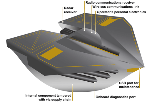
Figure 3 from the GAO report: Weapons Include Numerous Interfaces That Can Be Used as Pathways to Access the System (Represented via Fictitious Weapon System for Classification Reasons) Source: GAO analysis of Department of Defense information, GAO-19-128.
The amount of software embedded in weapon systems and subsystems has increased exponentially, expanding the respective weapons’ vulnerable surfaces. According to the military’s Director of Operational Test and Evaluation, “any exchange of information is a potential access point for an adversary. Even “air gapped” systems that do not directly connect to the Internet for security reasons could potentially be accessed by other means, such as USB devices and compact discs. Weapon systems have a wide variety of interfaces, some of which are not obvious, that could be used as pathways for adversaries to access the systems, as is shown in Figure 3.”
If attackers can access one of those systems, they may be able to reach any of the others through connecting networks.
Figure 4 from the GAO report: Weapon Systems Are Connected to Networks That May Connect to Many Other Systems (Notional Depiction for Classification Reasons)
Further, the DOT&E found that some networks were not survivable — that is, able to maintain critical capabilities under applicable threat — in a cyber-contested environment. The Defense Science Board concluded in 2013 that “the adversary is in our networks.”
The GAO adds that it and other organizations have been sounding off about such threats since the early 1990s — around the time that GPS itself became operational.
Tests of major military programs conducted between 2012 and 2017 revealed mission-critical cyber vulnerabilities that adversaries could compromise. “Test teams were able to gain unauthorized access and take full or partial control of these weapon systems in a short amount of time using relatively simple tools and techniques. . . . Once they gained initial access, test teams were often able to move throughout a system, escalating their privileges until they had taken full or partial control of a system.”
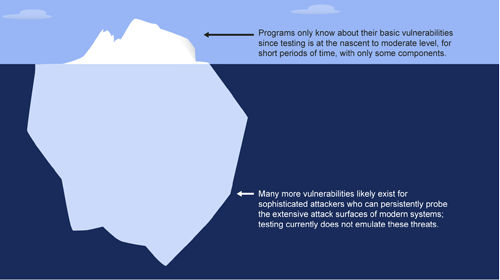
Figure 5: Vulnerabilities that the Department of Defense Is Aware of Likely Represent a Small Amount of Actual Vulnerabilities Due to Limitations in Cybersecurity Testing. Source: GAO analysis of Department of Defense information, GAO-19-128.
Beginning Steps
The Department of Defense is “still learning” how to address weapon system security and “still determining” what steps it may take. Implementation, once identified, will surely occupy an extended period. Complicating the picture, if DOD is able to make its newer systems more secure, yet connects them to older, vulnerable systems, the newer systems come into jeopardy.
Pass the Hash
A report appendix lists several different types of attacks with such pictorial names as: Man-in-the middle, Pass-the-hash, War driving, and Zero day exploit.
Respectively, these types of attacks connote:
• An eavesdropping attack in which the attacker intercepts to read or modify data communications to masquerade as one or more of the entities involved.
• Capturing an encrypted version of a username and password in order to authenticate to a server or service. The attacker does not have to decrypt the username and password (i.e., they do not actually know what they are), yet can still use them to log in to a system.
• Driving through cities and neighborhoods with a wireless-equipped computer — sometimes with a powerful antenna — searching for wireless networks potentially to exploit.
• Taking advantage of a security vulnerability previously unknown to the general public. In many cases, the exploit code is written by the same person who discovered the vulnerability. By writing an exploit for the previously unknown vulnerability, the attacker creates a potent threat since the compressed timeframe between public discoveries of both makes it difficult to defend against.
Dull, dirty and dangerous — those used to be the jobs relegated to autonomous systems. But a decade-plus of improvement in sensor and computing technology has brought autonomy into the mainstream as a defining technology of the future.
At September’s ION GNSS+ conference, I attended a panel titled “Autonomous Cyber-Physical Systems — The Way Ahead.” I came away astounded by how much is changing, and how fast, because of autonomous CPS.
The panel was chaired by John Raquet of the Air Force Institute of Technology and Zak Kassas of the University of California Riverside. It featured presentations covering topics such as the Columbus Smart City Challenge (Dorota Grejner-Brzezinska, The Ohio State University), benefits of precision agriculture (Steve Rounds, John Deere), robotic teammates on the battlefield (Brett Piekarski, U.S. Army), and UAV design and certification (Demoz Gebre-Egziabher, University of Minnesota).
Autonomous cyber-physical systems (CPS) include unmanned aerial vehicles, self-driving cars and unmanned underwater vehicles. The panel addressed the state of autonomous CPS as well as challenges that need to be addressed as we integrate these systems into our environment.
Rather than discuss a specific application, Michael Veth, CEO of Veth Research Associates, tackled a difficult question: Just how much autonomy do we give machines?
“Rigorous risk assessment is the most critical component of machine-controlled autonomous systems,” Veth said. He said the scope of the machine’s autonomous decisions should be limited to the minimum necessary — in other words, avoid the scenario depicted in the movie WarGames.
Another rule: “Don’t put beta software on the street,” he said, recalling the Tesla autosteer system that resulted in a death. Instead, follow DARPA’s example, with its extensive sandbox testing.
Summing up his presentation, Veth provided five guidelines for developing autonomous machines:
Perform rigorous risk assessments;
limit range of action to the minimum required;
use generative models whenever possible;
train and evaluate using maximum available data; and
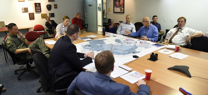
A 2016 wargame involving the Air Force and Navy at the Naval Postgraduate School. (Photo: U.S. Navy)
The 12th in a series of Air Force Space Command Wargames concluded Oct. 19 at the Maxwell Air Force Base in Alabama. Set in the year 2028, Schriever Wargame 2018 (SW 18) explored critical space and cyberspace issues in depth.
The objectives of the wargame centered on:
examining how international partner capabilities can deter an adversary from extending or escalating a conflict into space;
gaining insight into resiliency, deterrence, and warfighting through international partner synchronization of space and cyberspace operations;
exploring various combined command and control (C2) frameworks to employ and defend air, space and cyberspace capabilities in support of global and geographic / regional operations;
identifying the strategic and operational contributions of space and cyberspace in a multi-domain conflict; and
exploring partnerships framed by a whole of governments approach (International, Civil, Commercial) to combined space and cyberspace operations.
The SW 18 scenario depicted a notional peer space and cyberspace competitor seeking to achieve strategic goals by exploiting those domains. It included a global scenario with the focus of effort towards the U.S. Indo-Pacific Command (USINDOPACOM) Area of Responsibility.
The scenario also included full spectrum threats across diverse operating environments that challenged civilian and military leaders, planners and space system operators, as well as the capabilities they employ.
Approximately 350 military and civilian experts from more than 27 agencies around the country as well as from Australia, Canada, France, Germany, Japan, New Zealand, and the United Kingdom participated in the Wargame.
Agencies that participated included: Air Force Space Command, Army Space and Missile Defense Command, Naval Fleet Cyber Command, the National Reconnaissance Office, Executive Agent for Space Staff, Air Combat Command, Office of the Secretary of Defense, USINDOPACOM, U.S. Strategic Command, U.S. Special Operations Command, U.S. Northern Command, the Intelligence Community, National Aeronautics and Space Administration, Office of Homeland Security, Department of Transportation, Department of State and Department of Commerce.
Harris Corporation and L3 Technologies Inc. have agreed to combine in an all-stock merger of equals to create a global defense technology leader focused on developing differentiated and mission-critical solutions for customers around the world.
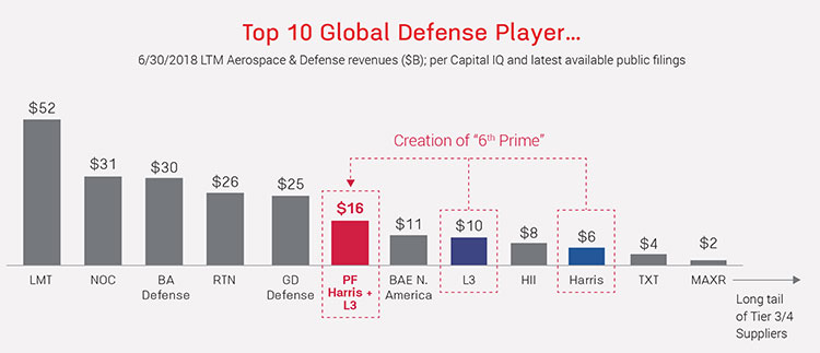
The combined company, L3 Harris Technologies, will be the sixth largest defense company in the U.S. and a top 10 defense company globally, with approximately 48,000 employees and customers in more than 100 countries.
For 2018, the combined company is expected to generate net revenue of approximately $16 billion.
Image: from Fact Sheet by Harris and L3 Technologies
According to the press release, increased scale will enable the combined company to be more cost competitive, expand capabilities to provide end-to-end solutions across multiple domains of air, sea, land, space and cyber, enhance leadership in RF and spectrum technologies and establish a leading platform-agnostic supplier and integrator.
L3 Harris Technologies will be headquartered in Melbourne, Florida, and led by a team that reflects the strengths and capabilities of both companies and will share equally in the integration process, the companies said.
With a combined workforce of 22,500 engineers and scientists, the combined company plans to accelerate investment in select technologies to expand leadership in key strategic domains including national security.
Image: from Fact Sheet by Harris and L3 Technologies
Company Backgrounds
Harris Corporation is a solves customers’ mission-critical challenges by providing solutions that connect, inform and protect. Harris supports government and commercial customers in more than 100 countries and has approximately $6 billion in annual revenue. The company is organized into three business segments: Communication Systems, Electronic Systems and Space and Intelligence Systems.
L3 Technologies is a provider of global ISR, communications and electronic systems for military, homeland security and commercial aviation customers. With headquarters in New York City and approximately 31,000 employees worldwide, L3 Technologies develops advanced defense technologies and commercial solutions in pilot training, aviation security, night vision and EO/IR, weapons, maritime systems and space. The company reported 2017 sales of $9.6 billion.
CEO Statements and Leadership
“This transaction extends our position as a premier global defense technology company that unlocks additional growth opportunities and generates value for our customers, employees and shareholders,” said Harris chairman, president and CEO William M. Brown. “Combining our complementary franchises and extensive technology portfolios will enable us to accelerate innovation to better serve our customers, deliver significant operating synergies and produce strong free cash flow, which we will deploy to drive shareholder value. Integration planning is already underway, and from our extensive experience with integration, we are confident in our ability to realize $500 million of annual gross cost synergies and $3 billion of free cash flow by year 3.”
L3 Chairman, President and Chief Executive Officer, Christopher E. Kubasik said, “This merger creates greater benefits and growth opportunities than either company could have achieved alone. The companies were on similar growth trajectories and this combination accelerates the journey to becoming a more agile, integrated and innovative non-traditional 6th Prime focused on investing in important, next-generation technologies. L3 Harris Technologies will possess a wealth of technologies and a talented and engaged workforce. By unleashing this potential, we will strengthen our core franchises, expand into new and adjacent markets and enhance our global presence.”
The combined company’s board of directors will have 12 members, consisting of six directors from each company. William M. Brown will serve as chairman and chief executive officer, and Christopher E. Kubasik will serve as vice chairman, president and chief operating officer for the first two years following the closing of the transaction. For the third year, Brown will transition to executive chairman and Kubasik to chief executive officer, after which Kubasik will become chairman and chief executive officer.
Additional senior leadership positions for L3 Harris Technologies will be determined at a later date.
Shareholder Information
Under the terms of the merger agreement, which was unanimously approved by the boards of directors of both companies, L3 shareholders will receive a fixed exchange ratio of 1.30 shares of Harris common stock for each share of L3 common stock, consistent with the 60-trading day average exchange ratio of the two companies.
Upon completion of the merger, Harris shareholders will own approximately 54 percent and L3 shareholders will own approximately 46 percent of the combined company on a fully diluted basis.
The merger is expected to close in mid-calendar year 2019, subject to satisfaction of customary closing conditions, including receipt of regulatory approvals and approval by the shareholders of each company.
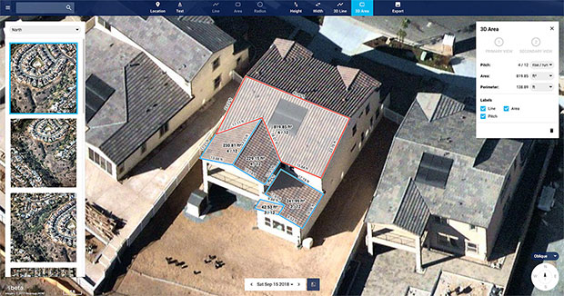
Nearmap high-resolution aerial image showcasing new toolset in MapBrowser, captured Sept. 15, 2018. (Image: Nearmap)
Nearmap has introduced a complete measurement toolset in MapBrowser for the solar, roofing and other rooftop industries.
The new tools allow users to measure roof-pitch, height, width and area, enabling roofers and solar installers to confidently measure rooftops and structures from high-resolution oblique aerial images, the company said.
The new MapBrowser helps customers significantly reduce onsite visits during the quoting and planning stages of projects and complements their remote roof/site inspection workflows, giving many small businesses the power of expensive systems that only large companies use.
“Gone are the days of climbing on roofs to take measurements,” said Tony Agresta, executive vice president of product at Nearmap. “Delivered to the cloud within days of capture, our aerial imagery allows roofers, solar companies and other small businesses to carry out assessments from the comfort of their office. Once the domain of large companies, the new features provide businesses of all shapes and sizes with the tools they need to save time, plan and estimate more accurately at a fraction of the price.”
Using Nearmap’s new tools, roofers and solar companies will be able to:
Prospect more efficiently by viewing and expanding opportunities through aerial maps instead of other, more traditional ways.
Process leads more quickly by qualifying prospects prior to visiting a potential job.
Reduce costs associated with the qualification and proposal stages.
Create better proposals using up-to-date, high-resolution photos, giving companies a better chance at winning a client’s business.
Close more sales with the most accurate and competitive quotes.
Increase revenue without adding systems or headcount.
Businesses in construction, home building, painting, insurance and other industries can also benefit from these new tools to accurately measure areas on properties in three dimensions. Nearmap’s aerial imagery can help users to show context for work being done, and the imagery can be annotated with notes, drawings and measurements that provide details of the plan.
Nearmap Oblique imagery can be accessed through a standard web browser using Nearmap’s intuitive MapBrowser application. In addition, Nearmap Oblique photos are published at sub-7.5cm ground sampling distance (GSD) — better than satellite imagery — which allows users to see great detail, Nearmap said.