Category: Applications

  • Rugged tablet purpose-built for high-accuracy measurements

    Rugged tablet purpose-built for high-accuracy measurements

    RealSense 3D camera is fully integrated to capture real-time detailed images
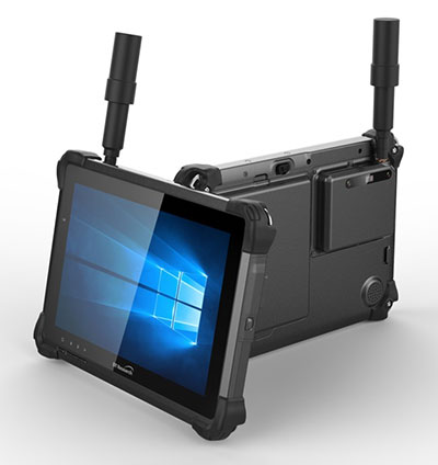
    DT301X rugged tablet. (Photo: DT Research)
    DT301X rugged tablet. (Photo: DT Research)

    DT Research has released the DT301X rugged tablet, a lightweight military-grade tablet that is purpose-built to enhance the precision of crime and crash scene reconstruction, bridge and other construction inspections, and 3D surveying.

    DT Research made the announcement at Intergeo, being held Oct. 16-18 in Frankfurt, Germany.

    The DT301X rugged tablet has MIL spec and IP ratings, yet is lightweight — offering the versatility to be used in the field, office and vehicles, the company said. A high brightness 10.1-inch touchscreen offers flexible viewing in a wide range of lighting, and an Intel eighth-generation Core i5 or i7 processor offers high-performance while still being energy-efficient.

    With high-capacity 60- or 90-watt hot-swappable batteries, the DT301X keeps working continuously, complemented with a variety of battery chargers so fully-charged batteries are always available.

    The DT301X integrates the Intel RealSense depth camera, which provides real-time 3D imaging to shorten the workflow and create extremely accurate measurements for CAD, engineering, design, utility management and crime-scene forensics.

    Scientific grade data, which is important for court evidence as well as building plans, just got easier and is now available to a wider group of workers. With this 3D camera technology, depth perception is integrated to add the most accurate image to make projects stay factual and consistent, DT Research said.

    Optional data capture offered on the DT301X besides the 3D camera are a 2D barcode scanner for equipment/location tags, a dual-frequency GNSS module for real-time mapping and positioning, long-range Bluetooth for 1000-foot range, and 4G LTE mobile broadband for the latest in high speed communications.

    The rugged tablet gives detailed accuracy combined with the latest 3D camera technology all in one device that is rugged and easy to use in the field.

    “DT Research’s high-performance rugged tablet equipped with the RealSense depth camera combined with DotProduct’s Dot3D Scan software allows speedy and efficient field-to-office 3D workflows for a wide range of applications from construction verification to asset management to crime scene mapping,” said Tom Greaves, chief marketing officer at DotProduct.

    The DT301X is built to operate in real-world situations, with an IP65 rating for water and dust, MIL-STD-810G for shock and vibration protection, and MIL-STD-461F for EMI and EMC tolerance. The tablet can be paired with a detachable keyboard for ease of use, and Wi-Fi and Bluetooth for smooth networking and constant communications.

    The DT301X rugged tablet is compatible with existing applications with Microsoft Windows 10 IoT Enterprise operating systems for flexible integration, and it brings together the advanced workflow for data capture, accurate positioning and data transmitting.

    Whether at the electrical substation, at the crash scene, or at the construction site, the DT301X is ideal for accurate measurements as well as other needed tasks, able to travel to wherever the work is.

    The DT301X rugged tablet will be available in November 2018 from DT Research’s authorized resellers and partners.

  • Harxon brings latest surveying technologies to Intergeo

    Harxon brings latest surveying technologies to Intergeo

    Photo: Harxon
    Photo: Harxon

    Harxon is showcasing high-precision positioning GNSS antennas and its latest wireless data transmission technologies for surveying applications at Intergeo, Oct. 16-18, in Frankfurt, Germany.

    Image: Harxon
    Image: Harxon

    X-Survey is an 4-in-1 OEM antenna for both navigation and communication in the real-time kinematic (RTK) surveying applications. It provides standard Wi-Fi, Bluetooth, 4G, and multiple-constellation signal reception for GNSS positioning.

    Its 3D design ensures a higher phase center stability and longer communication distance at a 360-degree direction, while lowering the impact of electromagnetic interference (EMI), hence increasing the overall machine efficiency and simplifying the RTK integration, the company said.

    Photo: Harxon
    Photo: Harxon

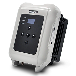
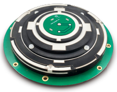
    The smart eRadio is a long-range and highly efficient radio modem designed to support RTK applications in surveying and precision agriculture. It can automatically identify RTK serial baud rate and provide a plug-and-play form for easy connection between eRadio and RTK.

    According to Harxon, the eRadio’s diagnostic reporting software can configure data and update radio status, allowing users to effectively deal with potential issues. In addition, it is equipped with the unique ETALK communication protocol that increases the communication distance by 20 percent.

    Other Harxon GNSS products showcased at Intergeo are for UAVs and precision agriculture, as well as surveying.

    The D-Helix antenna HX-CHX600A is featured with its patented D-QHA technology.


    Both 3D structured and mini-designed choke-ring antennas HX-CGX601A and HX-CGX611A can be used for base-station communication.

    The multi-constellation survey antenna GPS 1000, frequency hopping modem HX-DU2017D and external radio modem HX-DU8608D are also popular products for high-precision performance.


  • Live from Intergeo 2018

    Logo: IntergeoThe GPS World staff is reporting from Intergeo Oct. 16-18 in Frankfurt, Germany. The massive trade show, dubbed the “global hub of the geospatial community,” brings together more than 17,000 visitors from more than 107 countries and features approximately 640 exhibitors. Check out the latest industry news, as well as photos and videos from the event.

    Videos

    Choose the video you’d like to watch by clicking the icon in the top left hand corner of the video screen.

    News

  • U.S. Army invests in virtual reality training

    U.S. Army invests in virtual reality training

    The U.S. Army considers virtual reality training as an important path ahead to prepare warfighters.

    The U.S. Army awarded Bohemia Interactive Simulations (BISim) a major extension to demonstrate technologies for a cloud-enabled, virtual world training capability.

    BISim is a global developer of advanced military training and simulation software.

    The contract award helps meet the requirements of the Army’s Synthetic Training Environment (STE) initiative. STE aims to converge virtual, constructive and gaming training environments into a single unified architecture.

    The ambitious STE project will enable simulation systems Army-wide to leverage a persistent virtual world for any imaginable training need, including support for multi-domain operations incorporating cyber and space.

    Central to STE is a cloud-enabled One World Terrain (OWT) that will let warfighters conduct virtual training and complex simulations anywhere on a virtual representation of the Earth. OWT will leverage cloud technologies to deliver to the point of need, ensuring a common and high-fidelity whole-Earth terrain representation for a multitude of different simulation systems.

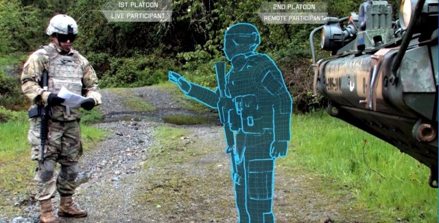
    The Synthetic Training Environment will assess Soldiers in enhancing decision-making skills through an immersive environment. (Photo: U.S. Army)
    The Synthetic Training Environment will assess Soldiers in enhancing decision-making skills through an immersive environment. (Photo: U.S. Army)

    “The U.S. Army’s vision for STE marks a monumental change in how they acquire, develop and deliver new simulation and virtual training technologies to soldiers,” said Pete Morrison, BISim’s co-CEO and chief product officer. “We’re honored to be selected to assist the Army in developing innovative solutions that will shape the future of how virtual training is used to enhance operational readiness.”

    BISim has been developing its next generation of simulation technologies since 2014. The new technology suite includes a cutting-edge, military-specific whole-earth game engine, deterministic AI, an efficient geospatial terrain server and component-based development technology.

    BISim technology underpins funded research and development for One World Terrain. Additionally, BISim recently demonstrated Reconfigurable Virtual Collective Trainer (RCVT) prototypes for STE. The latest OTA extension is a significant ramp up in the breadth and ambition of the technology being demonstrated.

    BISim’s STE offering includes four core technologies uniquely suited to meeting future military simulation requirements (including U.S. Army requirements).

    VBS Blue. A high-performance, whole-planet data ingestion and rendering engine with a very high level of procedural detail, designed to ingest any conceivable terrain data format as well as source data directly. VBS Blue will support networked (cloud) terrain paging and geo-specific insets as well as the latest graphics technologies. It provides photorealistic detail, and includes a massive vegetation library representing every region on Earth. The technology is highly applicable across all types of image generation and is optimized for many AR/VR applications.

    STEWS. A geospatial data server that provides efficient networked access to the various data sources required for rendering applications. STEWS provides a curated database of terrain data layers that can be streamed into any STE-connected client application at run time (including non-BISim applications). Any application connected to STEWS can stream high fidelity terrain data in a performant manner. Both new and legacy terrain formats are supported through new STEWS plug-ins.

    VBS Control. High fidelity, doctrinal and deterministic entity-level artificial intelligence that is uniquely suited to operation on whole-earth terrain. VBS Control runtime offers highly efficient real-time path planning that allows AI to move seamlessly through open, urban and interior spaces. The VBS Control Editor allows powerful new AI behaviors to be developed at both the individual entity level and at higher levels of command for land, sea and air assets.

    Gears. A software development framework that defines a standard way for components to communicate through formal interfaces. Gears uses a component-based architecture to promote rapid development by building applications from self-contained systems and having them communicate via formally defined interfaces. This allows functionality to be reused and avoids the complexity of tightly coupled systems. See www.gears.studio for more information.

    The Army also selected BISim for a five-year contract to support their Games for Training Program and BISim’s technology is being rolled out on CCTT (the U.S. Army’s largest ground simulator training program).

  • UAV images show inspection action

    The UAV inspection industry continues to grow, as evidenced by these photos of actual end-user application. Unmanned systems follow precise flight paths to gather the data needed for inspection missions in the fields of insurance (home roof inspection), mining, construction and the pulp paper industry.

    Kespry drone inspecting damaged roof for insurance claim. (photo Nathan Stump/Kestry)
    Kespry drone inspecting damaged roof for insurance claim. (Photo: Nathan Stump/Kespry)

    A free webinar on Thursday, Oct. 25 will show more of these applications and cover the requirements and challenges for positioning technology in commercial applications in urban and remote areas, including those generated by concerns about interference and spoofing.

    In the free webinar, attendees will learn:

    • Latest trends and challenges for drone-based aerial intelligence platforms for insurance and roofing applications
    • GNSS technology requirements for safe UAV BVLOS operations and a view of the regulatory frameworks
    • Importance of UAS traffic management systems (UTM)
    • Use cases in linear infrastructure inspection (railways, roads, power lines and others)
    • Challenges for GNSS systems in autonomous aerial vehicles and growing concerns about safety
    • Robustness of multi-GNSS receivers to jamming and spoofing
    • Latest innovation in GNSS technology concerning inspection applications and real-time accuracy/reliability
    Earthworks contractors use this drone technology to perform detailed topographic surveys of project sites throughout all phases of construction. The new survey tool is reducing costs and time, allowing earthworks contractors to increase their profitability and ensure project success. (photo Paul Ross/Kespry)
    Earthworks contractors use this drone technology to perform detailed topographic surveys of project sites throughout all phases of construction. The new survey tool is reducing costs and time, allowing earthworks contractors to increase their profitability and ensure project success. (Photo: Paul Ross/Kespry)

    In addition to a tailored application for roof inspections, targeted at insurance companies, UAV manufacturer Kespry provides a complete solution for construction and engineering companies to manage proposed and active earthwork operations. Without using multiple, cumbersome ground control points, survey-grade field data can be collected for an entire site in as little as 30 minutes.

    In the webinar,  attendees will learn how drone technology is being used to:

    1. Validate proposed earthwork – reduce rework and extra earthmoving costs before the job begins
    2. Safely measure earthwork activity – ensure subcontractor work and delivered material are constantly measured
    3. Perform regular earthwork progress topos – accurately document completed grading and drainage phases

    Further application examples in construction projects will show how drones are providing construction companies with a new method for accurate survey work throughout their entire worksite that can:

    Tablet software for UAV inspection enables 1-hour claim filing (Photo: Nathan Stump/Kespry)
    • Reduce up to 20 percent of total project costs by eliminating rework through regular cut and fill analysis of drone data
    • Eliminate up to 10 percent of earth moving costs through more accurate volumetric analysis
    • Perform more frequent surveys in-house with drones, reducing traditional survey equipment and service costs.
    x
    Kespry provides a complete solution for construction and engineering companies to better manage proposed and active earthwork operations. Without using multiple, cumbersome ground control points, survey-grade field data can be collected for an entire site in as little as 30 minutes. (Photo: Nathan Stump/Kespry)

    In the first example show above, insurance claims for roof damage, the fully-autonomous system improves safety, reduces loss adjustment expenses, and delivers more accurate risk assessments, while reducing overall costs. For commercial property, the UAV solution helps prevent losses and informs underwriting decisions with high-resolution aerial and thermal imagery to identify exposures. Accurate, unbiased reports are easily prepared and shared with all parties. Mobile tools are provided to review inspection quality imagery within minutes of flight; artificial intelligence (AI) technology generates fully-dimensioned wireframes and 3D roof models

    Drones for the pulp and paper industry
    The drone and analytics platform enables companies to improve profitability through quick, cost-effective, and accurate surveying of chip and roundwood sites.

    UAV applications in pulp and paper industry will be demo'd in the Oct 25 webinar (photo Jason Nichols/Kestry)
    UAV applications in pulp and paper industry will be demo’d in the Oct 25 webinar (Photo: Jason Nichols/Kespry)

    Kespry enables production plant and production managers to analyze stockpile inventories, better manage supply chain activity, and improve site operations — maximizing profitability across production and supply chain operations.

    The company also supplies a drone-based AI platform for the aggregates and mining industry supplies accurate inventory management and mine planning. It will be demonstrated in the free October 25 webinar.


  • Garmin’s latest watch features GPS, GLONASS and Galileo

    Garmin’s latest watch features GPS, GLONASS and Galileo

    Garmin is now offering a GPS, GLONASS and Galileo watch called Instinct. Instinct is a strong and durable watch with GNSS support, plus built-in 3-axis compass, barometric altimeter and wrist-based heart rate sensor.

    The watch includes a built-in sports apps, smart connectivity and wellness data.

    Photo: Garmin
    Photo: Garmin

    “We are thrilled to add Instinct to our adventure watch lineup, an approachable smartwatch that is rugged and reliable,” said Dan Bartel, Garmin vice president of global consumer sales. “Instinct is perfect for those who spend their time outdoors and demand a device built tough to stand up in the elements.”

    The Instinct is built to endure challenging environments, constructed to military standards (MIL-STD-810G) for thermal, shock and water resistance (rated to 100 meters) with a fiber reinforced polymer case. The chemically strengthened and scratch-resistant display is readable in direct sunlight, and the fully vented silicone bands include two independent, removable keeper loops to ensure a secure fit.

    The multi-GNSS feature helps users track their location in challenging environments. The Garmin Explore app helps plan the trip in advance, and the TracBack feature can navigate the same route back to the starting point.

    The built-in heart-rate sensor helps monitor heart rate, steps taken, distance traveled, calories burned and more.


  • NCTech to unveil iSTAR Pulsar developments at Intergeo 2018

    NCTech, a developer of reality imaging systems, will showcase its iSTAR Pulsar mobile 360-degree data capture system at Intergeo in Frankfurt, Germany.

    Companies at Intergeo, including GeoSLAM and Orbit Geospatial Technologies, will also unveil innovative developments that incorporate iSTAR Pulsar.

    iSTAR Pulsar is NCTech’s professional edge-to-cloud big data system, optimized for capture on the move. iSTAR Pulsar is designed to capture 360-degree data while mounted on a vehicle, drone or on foot.

    At Intergeo, NCTech will be showing a demonstration of a future feature in its cloud-based processing software VR.WORLD that uses artificial intelligence and image recognition to analyze the images captured by iSTAR Pulsar. This means that objects like cars, trucks, traffic lights, road signs, pedestrians and cyclists can be automatically identified in images, the company said.

    Handheld 3D mobile mapping company GeoSLAM also will introduce new developments at Intergeo, including an innovation that integrates with iSTAR Pulsar.

    “We immediately saw the potential for collaboration when NCTech introduced the iSTAR Pulsar,” said Mark Reid, head of strategic business development, GeoSLAM. “And now we’re excited to show the attendees at Intergeo what we’ve been working on.”

    Orbit GT has updated its mobile mapping software to enable iSTAR Pulsar data to be integrated into its smart 3D mapping solutions.

    “We’re very pleased to announce that Orbit GT solutions now support data from NCTech’s iSTAR Pulsar,” said Peter Bonne, CEO, Orbit GT. “We’ll be showcasing the great 360-degree imagery captured by iSTAR Pulsar at our booth.”

    “We launched iSTAR Pulsar earlier this year, so it’s great to see that key industry players like GeoSLAM and Orbit GT are already leveraging its capabilities in their own developments,” said Andrew Baddeley, technical sales director, NCTech. “Combined with the exciting new AI developments from our labs, we look forward to showing everyone at Intergeo how we are helping to virtualize the world.”

  • SBG Systems offers GNSS+inertial navigation for surveying, UAVs

    SBG Systems offers GNSS+inertial navigation for surveying, UAVs

    SBG Systems is launching the Navsight Land & Air Solution, high-performance inertial navigation designed to make surveyors’ mobile data collection easier, whether for mobile mapping, GIS or road inspection.

    SBG Systems will release the Navsight Land & Air Solution at the Intergeo show in Frankfurt, Germany, Oct. 16-18.

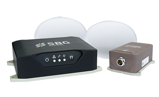
    The solution consists of an inertial measurement unit (IMU), available at two different performance levels, connected to Navsight, a rugged processing unit embedding fusion intelligence and a GNSS receiver. It also has connections for external equipment such as lidar, cameras or computer.

    Photo: SBG Systems
    Photo: SBG Systems

    The Navsight Land & Air Solution is the result of more than 10 years of experience in the mobile positioning industry, especially in the unmanned industry where position reliability is mandatory. SBG’s fusion algorithms allow the company to get the best performance from inertial, odometer and GNSS technologies; exclude false GNSS fixes; and improve the trajectory in complicated areas such as urban canyons, forests and tunnels.

    According to the company, the Navsight Land & Air Solution supports all GNSS constellations, real-time kinematic (RTK) and precise point positioning services such as Omnistar and TerraStar.

    SBG IMUs are easy to install, the company said. The sensor alignment and lever arms are automatically estimated and validated. Once connected to the Navsight processing unit, the web interface guides the user to configure the solution. A 3D view of the vehicle shows the entered parameters so that the user can check the installation. By choosing the vehicle, such as a plane or a car, the inner algorithms are automatically adjusted to the application. The Navsight unit also integrates LED indicators for satellite availability, RTK corrections and power.

    INS/GNSS Post-Processing Software. Qinertia, the SBG post-processing software, provides access to offline RTK corrections from more than 7,000 base stations in 164 countries. Trajectory and orientation are greatly improved by processing inertial data and raw GNSS observables in forward and backward directions.


  • Air Force Space Command conducts Schriever Wargame 2018

    Air Force Space Command conducts Schriever Wargame 2018

    The Air Force Space Command will conduct the 12th Schriever Wargame Oct. 11 at the Maxwell Air Force Base in Alabama.

    The Schriever Wargame scenario, set in the year 2028, will explore critical space issues and investigate the integration activities of multiple agencies associated with space systems and services. Schriever Wargame 2018 (SW 18) will include international partners from Australia, Canada, France, Germany, Japan, New Zealand and the United Kingdom.

    The objectives of the wargame are centered on:

    1. examining how international partner capabilities can deter an adversary from extending or escalating a conflict into space;
    2. gaining insight into resiliency, deterrence, and warfighting through international partner synchronization of space and cyberspace operations;
    3. exploring various combined command and control (C2) frameworks to employ and defend air, space and cyberspace capabilities in support of global and geographic/regional operations;
    4. identifying the strategic and operational contributions of space and cyberspace in a multi-domain conflict; and
    5. exploring partnerships framed by a whole of governments approach (international, civil, commercial) to combined space and cyberspace operations.

    The SW 18 scenario depicts a notional peer space and cyberspace competitor seeking to achieve strategic goals by exploiting those domains. It will include a global scenario with the focus of effort towards the U.S. Indo-Pacific Command (USINDOPACOM) Area of Responsibility.

    A 2016 wargame involving the Air Force and Navy at the Naval Postgraduate School. (Photo: U.S. Navy)
    A 2016 wargame involving the Air Force and Navy at the Naval Postgraduate School. (Photo: U.S. Navy)

    The scenario will also include a full spectrum of threats across diverse operating environments to challenge civilian and military leaders, planners and space system operators, as well as the capabilities they employ.

    The Schriever Wargame Team will conduct the wargame on behalf of Air Force Space Command, headquartered in Colorado Springs, Colorado. Approximately 350 military and civilian experts from more than 27 commands and agencies around the country, as well as seven international partners, will participate in the wargame.

    U.S. commands and agencies participating in Schriever Wargame 2018 include:

    • Air Force Space Command
    • Army Space and Missile Defense Command
    • Naval Fleet Cyber Command
    • the National Reconnaissance Office
    • Executive Agent for Space Staff
    • Air Combat Command
    • Office of the Secretary of Defense
    • USINDOPACOM
    • U.S. Strategic Command
    • U.S. Special Operations Command
    • U.S. Northern Command
    • the Intelligence Community
    • National Aeronautics and Space Administration
    • Office of Homeland Security
    • Department of Transportation
    • Department of State
    • Department of Commerce.
  • U.S. Army establishes new requirements for GPS receivers, PNT solutions

    U.S. Army establishes new requirements for GPS receivers, PNT solutions

    The U.S. Army is drafting new rules for the use of GPS receivers in weapon systems to combat spoofing and jamming attacks, as well as signal loss in GPS-denied environments, according to news reports.

    The six- to seven-page capabilities requirements document is awaiting a signature from Army leadership, according to Willie Nelson, director of the assured PNT (positioning, navigation and timing) cross-functional team. Nelson spoke to reporters Oct. 9 at the Association of the U.S. Army annual meeting in Washington, D.C.

    The Army has been trying for years to complete a GPS requirements document, a “system of systems architecture for assured PNT.” But with virtually every device equipped with GPS, the document would have been too big and too broad, Nelson said.

    (Photo: U.S. Army)
    (Photo: U.S. Army)

    The approach now is for separate sets of requirements: one for mounted equipment (now complete and awaiting the signature), a dismounted requirement, and situational awareness.

    The difficulty facing the Army is the plethora of PNT systems in use. For instance, an armored personnel carrier may have five to seven unconnected GPS receivers, some with encryption, some without. The weakest receiver could negatively affect the vehicle, Nelson said.

    With the new requirements, Army vehicles will have a consolidated, networked, software-based PNT solution. Dismounted receivers used by soldiers will have similar requirements.

    Industry will be asked for specific solutions within each of the PNT sectors rather than an “all of the above” solution.

    The Army is also expected to create a training program for soldiers that operate PNT systems.

  • U.S. Army recognizes GeoDecisions for modernizing convoy mapping module

    Automated Movement and Identification Solutions (AMIS), a division of the U.S. Department of the Army, has bestowed a Certificate of Appreciation to GeoDecisions, Gannett Fleming’s geospatial technology division.

    The certificate recognizes GeoDecisions for its outstanding technical expertise and dedication in the modernization of the Transportation Coordinators’ – Automated Information for Movements System II (TC-AIMS II) Convoy Planning Highway Regulation (CPHR-M) module.

    TC-AIMS II CPHR-M is an advanced software solution used to plan the Army’s convoy movement around the globe. GeoDecisions integrated the Transportation Geospatial Information System (TGIS) map and routing tool through the TGIS application programming interface to embed the map within the TC-AIMS system.

    The TGIS integration with TC-AIMS provides enhanced, real-time mapping functions, faster processing speeds, and a more user-friendly experience.

    The recognition also honors the GeoDecisions team for its technical knowledge, attention to detail, and ability to recognize, understand and address issues quickly to allow CPHR-M to stay on schedule.

    The team’s efforts resulted in more than a dozen changes to the baseline to provide better performance and additional capabilities that were not identified at the start of the project.

    “It’s almost unheard of to receive an award like this from a government program, so we feel especially humbled by this honor,” said Brendan Wesdock, MCP, GISP, president of GeoDecisions. “We’ve built an exceptional team of geospatial professionals who continuously push the boundaries of geospatial technology to deliver the most effective and valuable solutions to our clients.”

    AMIS is the primary source of providing automated movement and identification solutions across the DOD and around the globe. AMIS is the essential supplier for Transportation Coordinators’ – Automated Information for Movements System II (TC-AIMS II) with approximately 5,000 active users.

    The GeoDecisions team (from left): Jay Ross, senior software test specialist; Jeff Carter, TGIS lead system administrator with sub-consultant Aegis Strategies, LLC; Steve Kraabel, senior client manager; Debra Houser, director of Application Development; Bret Huber, lead and software developer; (not pictured) Andrew Miller, developer. (Photo: GeoDecisions)
    The GeoDecisions team (from left): Jay Ross, senior software test specialist; Jeff Carter, TGIS lead system administrator with sub-consultant Aegis Strategies, LLC; Steve Kraabel, senior client manager; Debra Houser, director of Application Development; Bret Huber, lead and software developer; (not pictured) Andrew Miller, developer. (Photo: GeoDecisions)


  • Spireon launches GoldStar Connect for auto dealers, lenders

    Mobile app creates new connections for the vehicle finance industry and extends the value of GPS to consumers.

    Image: Spireon
    Image: Spireon

    Spireon Inc., the vehicle intelligence company, has introduced GoldStar Connect, a full-featured connected car mobile application that gives Buy Here Pay Here (BHPH) dealers and lenders the opportunity to increase customer loyalty and profitability.

    As the newest addition to the GoldStar GPS solution suite, GoldStar Connect helps dealers and lenders recoup the cost of GPS, while also increasing value, convenience and safety for consumers, the company said.

    The BHPH sector has long used GoldStar GPS to mitigate risk. Dealers and lenders rely on GoldStar to stay connected to their customers in order to facilitate payment collection, monitor default predictors, and streamline recoveries when necessary.

    With the new GoldStar Connect mobile app, consumers now have access to all the benefits of connectivity — real-time location access, trip history, vehicle health alerts and recovery solutions for stolen cars — as an add-on at the time of purchase, the company added.

    “In marrying the GoldStar solution with a consumer-facing mobile app, our dealer and lender customers not only improve asset management and protection, but also can offer their consumers a significant value add — modern connected car benefits regardless of the vehicle make, model and year,” said Reggie Ponsford, senior vice president of sales at Spireon. “We have had a number of larger BHPH dealers piloting the GoldStar Connect solution in the past few months and seeing up to 90 percent consumer sell-through.”

    With GoldStar Connect, consumers gain a host of added benefits with their car purchase, including:

    • Safety and Security. GPS tracking and geofencing capabilities enable consumers to know the location of the vehicle at all times, helping to ensure the safety of the vehicle and the driver
    • Trip History. provides visibility to the activity of the vehicle by date, time and duration
    • Smart Alerts. consumers receive notifications of speeding, geofenced locations and battery condition directly to their mobile devices
    • Stolen Vehicle Recovery. an in-app recovery guide provides vehicle location data and instructions to assist in reporting and recovery of a stolen car
    • Insurance Discounts. Many carriers provide discounts of up to 15%

    “Consumers want connected vehicle features and benefits, and the app helps dealers and lenders build customer loyalty while also driving additional revenue and margin,” continued Ponsford. “By bundling the purchase into the vehicle loan, it’s seamless and easy for dealers and buyers.”

    “We’re excited to help our customers in the vehicle finance industry evolve their thinking about GPS from solely managing risk to now providing an opportunity to increase consumer loyalty and profitability,” said Brian Deeley, director of product management at Spireon. “The GoldStar solution is trusted by more BHPH dealers than all of our competitors combined. The addition of GoldStar Connect creates even more distance between Spireon and the rest, maintaining GoldStar as the GPS gold standard for BHPH.”

    GoldStar Connect is now available and will be demonstrated in booth #208 at the National Alliance of Buy Here, Pay Here Dealers (NABD) Buy Here Pay Here Subprime Conference, Oct. 8-10, at the MGM Grand in Las Vegas. To book a demonstration at the conference, see Spireon at NABD.