The mobile mapping market size is expected to be worth more than $40 billion by 2024, according to a new research report by Global Market Insights.
The mobile mapping market is propelled by the increasing adoption of mobile devices such as smartphones and tablets across the globe. Smartphone users are extensively using mapping applications on their devices for navigation and driving assistance, the report said.
Furthermore, they are also leveraging on the GIS and GPS applications to access geo-referenced data for searching nearby restaurants, cinema halls and other landmarks. This is encouraging the technology companies to commence mapping across the globe to acquire accurate GIS data and provide an enhanced customer experience.
High initial investment is a major factor limiting the growth of the mobile mapping market. Currently, the market comprises a few major players with a long-standing expertise in location-based technologies. High initial investments in developing mobile mapping systems and assembling major components have restricted the entry of new players in the market.
According to the report, the software market is anticipated to grow at a CAGR of 15 percent over the projected timespan. The growing demand for geo-referenced data acquisition and data analysis software among the organizations is driving the mobile mapping market growth. The software assists organizations in simplifying the data extraction process by combining the vital details. It retrieves geographic and spatial data captured by the positioning devices to develop maps and other graphic displays. This data is also used by enterprises to build effective decision support systems, which will drive the market demand.
The report includes key industry insights in 250 pages with 341 market data tables and 38 figures and charts from the report, “Mobile Mapping Market Size, By Component (Hardware [Imaging Device, Laser Ranging Device & Scanning Device, Positioning Device], Software [Mapping Data Extraction, Data Processing], Service [Consulting, Integration & Maintenance, Managed Service]), By Application (Road & Railway Survey, GIS Data Collection, Vehicle Control & Guidance, Asset Management), By End-User (Agriculture, BFSI, Government & Public Sector, Real Estate, Retail, Mining, Telecommunication, Transport & Logistics), Industry Analysis Report, Regional Outlook (U.S., Canada, the United Kingdom, Germany, France, Italy, Spain, Australia & NZ, China, India, Japan, South Korea, Brazil, Mexico, Argentina, GCC, Israel, South Africa), Growth Potential, Competitive Market Share & Forecast, 2018 – 2024.”
The mobile mapping technology is used for conducting road and rail surveys, collecting GIS data, and developing vehicle control and guidance systems and asset management systems. The road and rail survey market is expected to register a growth rate of over 17 percent during the forecast period. It is used to analyze the road and rail infrastructure and plan the engineering operations with minimum disruptions. The surveying authorities across the globe are using mobile mapping technology to create maps for the transportation department for road assessment purposes.
The agriculture sector is estimated to grow at a CAGR of 22 percent during the forecast timeline. The integration of the GPS and GNSS devices into the farming process to acquire geospatial data is the primary factor driving the mobile mapping market share. Furthermore, the ability of the mobile mapping technology to monitor the crop yield and land variability also augments the demand for the technology among the farmers.
The European region accounted for over 25 percent global mobile mapping market in 2017. The increasing investments by the government agencies have accelerated the adoption of mobile mapping technology in the region. For instance, in 2017, the U.K. government established the Geospatial Data Commission to frame a strategy for using the public sector location data to support the country’s growth.
The Asia Pacific region will grow at a rapid pace over the forecast timespan. The rapid urbanization of the region and the growing number of infrastructural projects have fostered the growth of the mobile mapping market in the region. Moreover, the widespread adoption of smartphones has also driven the market size.
Prominent players operating in the mobile mapping market are Phoenix LiDAR, Sharp Corporation, Teledyne Optech, TomTom International, Topcon Positioning Systems, MapJack, Mapquest, Navteq, NCTech, Microsoft, Mitsubishi, NovAtel, Phaseone industrial, Hexagon, EveryScape, Foursquare Labs and XIMEA.
The major companies in the market are collaborating with other expert companies in the market to develop new product offerings and conduct strategic acquisitions to gain a competitive advantage over its competitors.
For instance, in 2017, Garmin acquired Navionics, a provider of electronic navigational charts to the marine industry. This acquisition is aimed at combining the data from Navionics charts and Garmin’s blue charts to develop improved navigational services to its customers. Similarly, in 2017, Hexagon entered into an OEM partnership with Smart Guided Systems to develop new precision technologies for commercial applications.
The global mobile mapping market research report includes an in-depth coverage of the industry with estimates and forecast revenue in USD respectively from 2013 to 2024, for the following segments.
Mobile Mapping Market, By Component
Hardware
Imaging device
Laser ranging and scanner device
Positioning device
Software
Mapping data extraction
Data processing
Service
Consulting
Integration & maintenance
Managed
Mobile Mapping Market, By Application
Road & railway survey
GIS data collection
Vehicle control & guidance
Asset management
Mobile Mapping Market, By End-User
Agriculture
BFSI
Government & public sector
Real estate & infrastructure
Retail
Mining
Telecommunication
Regions and Countries
North America
U.S.
Canada
Europe
UK
Germany
France
Spain
Italy
Asia Pacific
ANZ
China
India
Japan
South Korea
Latin America
Brazil
Mexico
Argentina
MEA
GCC
South Africa
Israel
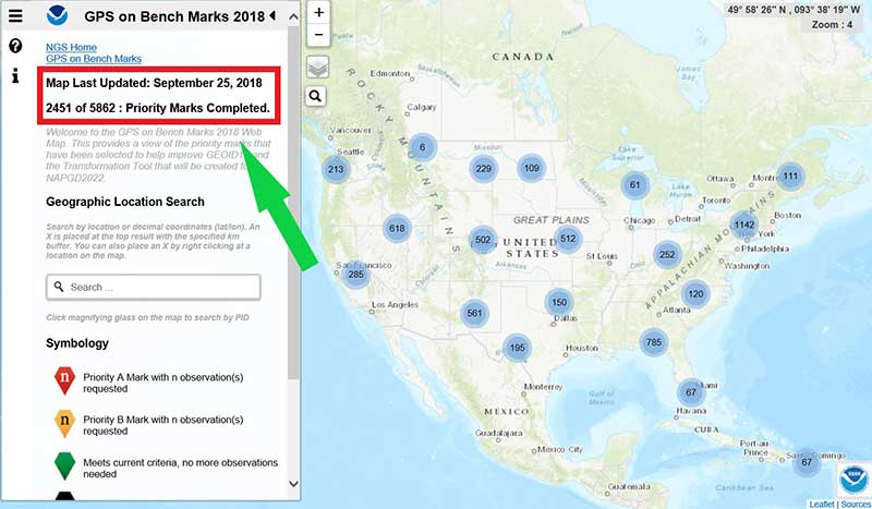
The number of GPS on Bench Mark (BM) stations highlighted as complete on the National Geodetic Survey (NGS) GPS tracking page as of Sept. 25 represents 43 percent of the total number of stations that need to be observed (2451 of 5862 Priority Marks Completed).
These new GPS on BMs observations will be helpful in identifying invalid GPS on BM stations that may have been used in the next hybrid geoid model.
Now that the 2018 GPS on BM program has officially ended for data included in the hybrid model GEOID18, NGS’ GPS on Bench Mark Program will soon be expanded to include other regions and will focus on data to improve NGS datum transformation tools.
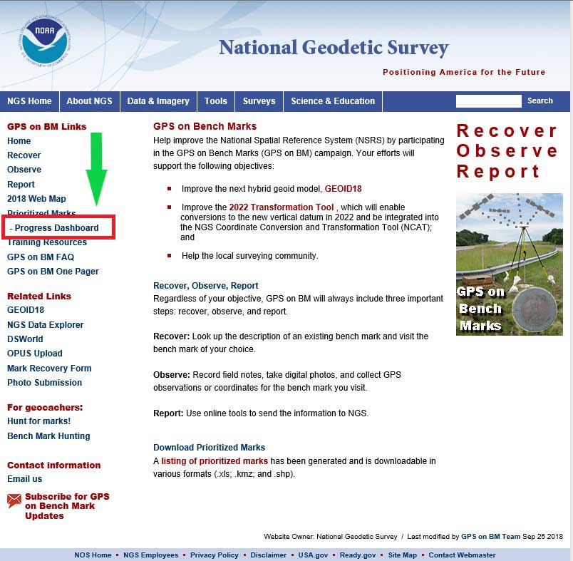
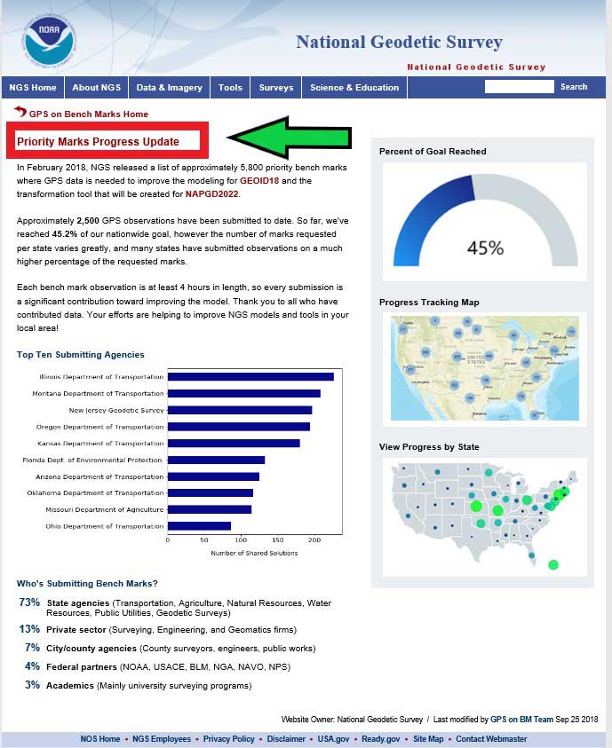
NGS has aided users that are submitting data using OPUS through their GPS on BM website service. Previous columns have highlighted the website. This column will highlight a new feature on the NGS GPS on BMs webpage that displays the progress of priority marks and its associated statistics. This webpage can be accessed through a link on the GPS on BMs Program main webpage — (see highlighted section in box tilted “GPS on BM Project Webpage”). The new webpage provides statistics by state as well as which agencies are submitting the most GPS on BMs data (see the box titled “NGS Webpage of Priority Marks Progress Update”).
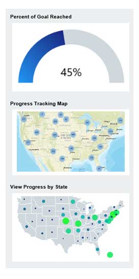
The right side of the webpage provides the percent of the goal reached, a link to the progress tracking map, and a link to progress by state (see box below). The first thing to notice that it provides a current percent of goal reached to date. In this example, the GPS on BM program is at 45 percent complete.
Right Side of Priority Marks Progress Update Webpage
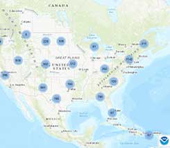
Clicking on the “Progress Tracking Map” picture will bring up the latest map update (see box below). As depicted in the box, as of Sept.25, 2,451 of 5,862 priority marks have been completed. The “Progress Tracking Map” provides information based on the last time the map was updated, and the “Percent of Goal Reached” is based on the most current OPUS Shared solutions submitted. NGS is working toward generating the map and solutions in near real time.
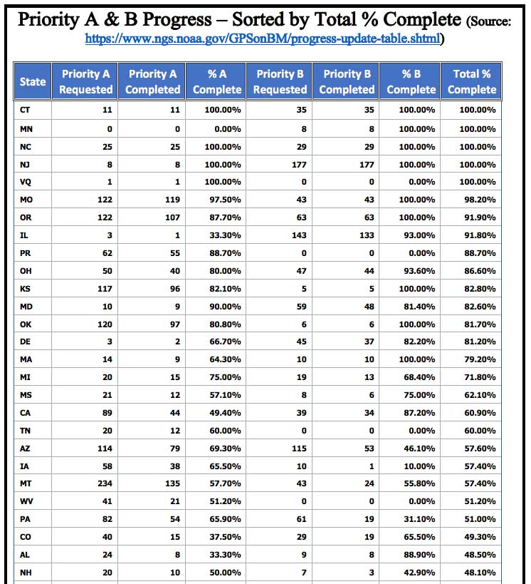
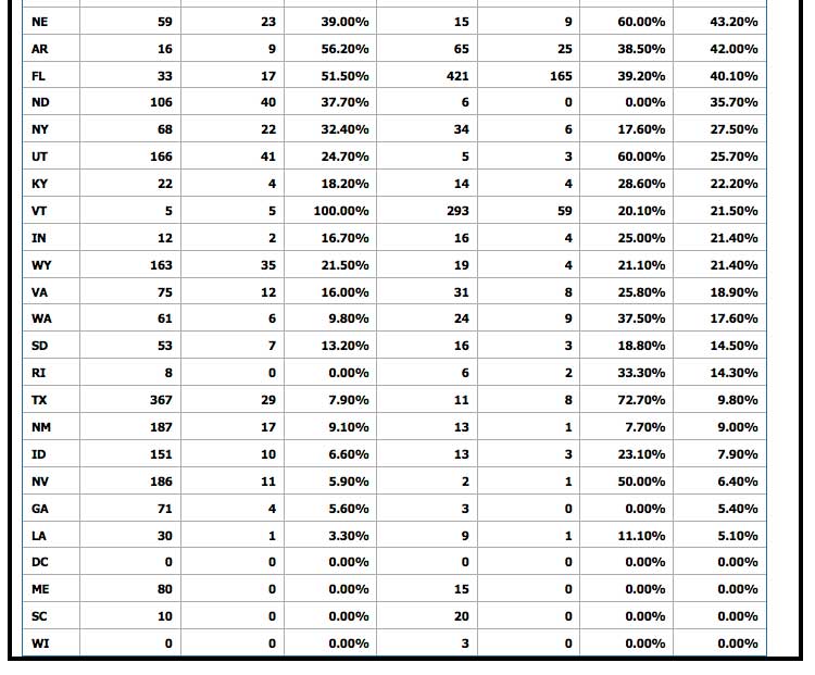
Clicking on the “View Progress by State” picture will bring up a table of progress of priority marks by state (see box titled “View by State Webpage”). As depicted in the box, the following statistics are provided for every state:
Source: National Oceanic and Atmospheric Administration
Source: National Oceanic and Atmospheric Administration
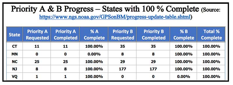
The following states have officially completed 100 percent of their priority A and B stations: Connecticut, Minnesota, North Carolina, New Jersey and U.S. Virgin Islands. Congratulations to these states (see the box titled “Priority A & B Progress – states with 100 percent complete”).
Priority A & B Progress — States with 100 percent complete
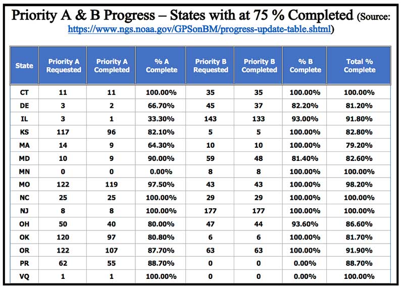
It should also be noted that there are 15 states that have completed at least 75 percent of their priority A and B stations (see box below). This is a tremendous amount of work, and everyone should be commended for participating in the GPS on BM program.
Priority A & B Progress – States with at 75 percent Completed
Source: National Oceanic and Atmospheric Administration
The left side of the webpage provides information on the top submitting agencies. As indicated in the box below, the Illinois Department of Transportation (DOT) and Montana DOT are the two top leaders in submitting GPS on BMs data. They have submitted well over 200 OPUS Shared solutions. The New Jersey and Oregon DOTs are close behind, providing about 200 OPUS Shared solutions.
Left Side of Priority Marks Progress Update Webpage
Source: National Oceanic and Atmospheric Administration
It’s not surprising to see that state agencies have provided the most submissions to the GPS on BM project (73 percent). It’s very encouraging to see that the private sector has provided 13 percent. Having an accurate and reliable hybrid geoid model will assist surveyors in performing their jobs as well as improve their efficiency in performing geodetic surveys requiring heights.
This column provided an update and status report on stations observed in support of the 2018 GPS on BMs program, and highlighting a new NGS GPS on BMs webpage that displays the progress of priority marks and its associated statistics. The number of GPS on Bench Mark stations completed as of Oct. 1 represents 45 percent of the total number of stations that need to be observed.
As I have explained in previous columns, there were many stations with invalid heights that could be used in the next hybrid geoid model unless more bench marks with valid NAVD 88 heights were observed with GNSS.
Many stations with potential invalid published orthometric heights have been identified by the GPS on BM program. This information will be very useful to the surveying and mapping community as well as to NGS.
NGS’ official date for accepted data for inclusion in the next hybrid geoid model, GEOID18, was Sept. 21. However, any OPUS Shared observations submitted before the final version of GEOID18 has a possibility of being included in the model. Even if it’s not included in the hybrid model, it will be very useful for evaluating the reliability of the model.
After the hybrid geoid model, GEOID18, is published, NGS’ GPS on Bench Mark Program will expand to include other regions and will focus on data to improve NGS datum transformation tools. I encourage everyone to continue supporting the GPS on BMs program — not only for improving the development of the 2022 transformation tool, but to assist in identifying bench marks in your local area that have invalid published orthometric heights due to movement.
Once NGS publishes the next hybrid geoid model, GEOID18, OPUS results will probably provide an estimate of the NAVD 88 orthometric height computed using GEOID18 similar to what it does now using GEOID12B.
In my opinion, the results of GEOID18 will be better than GEOID12B in most areas of the United States and should be helpful in identifying stations that have moved since they were last leveled. Submitting your results to OPUS Shared will provide a way for others to analyze the results to determine whether a station has an issue that requires attention.
Honeywell has signed an agreement with the Greek Ministry of Maritime Affairs and Insular Policy to upgrade Greece’s search-and-rescue operations using next-generation, satellite-based tracking technology.
Under the agreement, Honeywell will provide the Hellenic Center of Mission Control with eight satellite antennas, three rescue control systems and computer equipment, as well as installation, customization, training and technical support services for seven years.
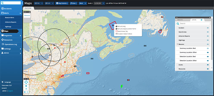
Using satellite signals, Honeywell’s technology can precisely locate emergency distress beacons and coordinate the deployment of rapid response teams, the company said.
The technology incorporates the COSPAS-SARSAT system, an international satellite-based program for distress alert detection and information distribution.
“By leveraging a network of ground-based antennas and medium earth orbit satellites, we can more precisely locate distress signals from emergency beacons,” said Mehrez Hached, director of business development for Honeywell’s Global Tracking and Search and Rescue business. “This Honeywell solution will help the Greek National Search and Rescue Coordination Center and the Hellenic Coast Guard save lives by quickly identifying aircraft, ships and people in distress regardless of how remote their location.”
Honeywell will install the satellite antennas on sites operated by the Hellenic Air Force and deploy management and surveillance equipment to the Hellenic Coast Guard Headquarters in Piraeus, Greece.
Honeywell’s search and rescue solutions are part of the company’s Safety and Productivity Solutions business. Honeywell provides fixed antennas, terminals, consoles and software applications to quickly locate missing assets on land or at sea and minimize emergency response times.
The company’s software offerings include SARMaster Search, a full-featured incident management application used by frontline operators to coordinate rescue operations, which has helped save tens of thousands of lives.
Honeywell’s tracking technology was incorporated into the European Space Agency’s Galileo search-and-rescue program, a pan-European program designed to dramatically reduce emergency response times using geo-positioning satellites.
A roundup of recent products in the GNSS and inertial positioning industry from the October 2018 issue of GPS World magazine.
OEM
Anti-spoofing
Provides mitigation and reporting
Photo: Regulus
The Pyramid GNSS allows detection, mitigation and reporting of spoofing of the GNSS system, while still providing accurate positioning (jamming protection will be available in a future version). Version 2 of the Pyramid GNSS adds a software-only version, making it available to numerous applications and enabling GNSS to perform seamlessly under spoofing and jamming conditions. The device is designed for any system depending on GNSS navigation or precise timing, including cars, drones, ships, robots, financial institutions and stationary infrastructure, such as power plants and power grids. The Pyramid GNSS connects externally and integrates seamlessly with existing GNSS receivers, adding reliability and protection to the system. It offers full GNSS support including for BeiDou, Galileo and GLONASS.
Swift Navigation has upgraded the firmware of its flagship product — the Piksi Multi GNSS receiver. This marks the sixth major release to Piksi Multi since it was launched in February 2017. The upgrade is available free of charge to Swift customers. The firmware release also enhances Duro, the ruggedized version of the Piksi Multi receiver housed in a military-grade, weatherproof enclosure for long-term outdoor deployments. Firmware Release 2.0 for Piksi Multi and Duro supports two additional major satellite constellations — Chinese BeiDou (B1/B2) which, once completed, will contain 37 satellites, and Europe’s Galileo (E1/E5b), which will eventually consist of 30 satellites. Piksi Multi’s performance will further improve for future satellites. The addition of BeiDou and Galileo creates more robust positioning in a variety of challenging sky-view environments.
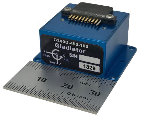
The G300D gyro is a three-axis, inertial rate system gyroscope. Measuring 0.67 cubic inches, it features low power and high speed, making it suitable for image stabilization applications. The G300D has message timing under 150 microseconds and output data rates up to 8 kHz with external sync. A micro-electro-mechanical gyroscope, it has an ARW of <0.0028 degrees/sec/√Hz and an option for both 24 and 32-bit LSB for exceptional resolution. Users can configure the G300D using a software development kit or through software protocols to simplify the integration process. The G300D gyro is non-ITAR.
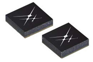
Two new GNSS low-noise amplifier (LNA) front-end modules, the SKY65933-11 and SKY65943-11, integrate Skyworks’ proprietary TC-SAW filters. The modules are designed specifically for internet of things (IoT) applications including smartwatches, action cameras, drones, asset trackers and personal navigation devices. They are designed for wireless module and IoT device manufacturers, providing a turnkey GNSS connectivity solution in a compact form factor. Both solutions offer integrated pre- and post-filter LNA and matching to reduce printed circuit board (PCB) area versus a discrete implementation; single DC supply for design flexibility and simplicity; multi-GNSS compatibility to cover GPS, GLONASS, Galileo, BeiDou and QZSS receiver applications in the 1559–1606 MHz frequency range; extremely low leakage current (1 uA max) benefitting battery-powered IoT devices; and highly manufacturable and low-cost surface-mount technology in a 2.5 x 2.5-millimeter multi-chip module package.
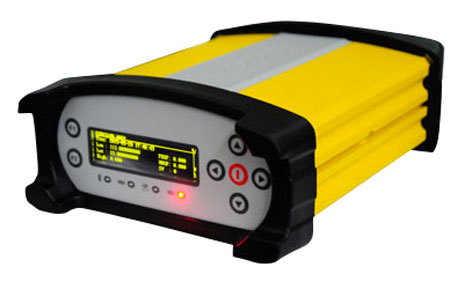
The Net20 Pro provides high-quality data for users interested in the proximity and reliability of a reference station while eliminating real-time kinematic (RTK) corrections service charges. It uses multi-frequency, 555-channel technologies in a rugged casing to deliver accurate and effective positioning data even in harsh environments. It can be configured for correction data reception in client mode to calculate a fixed RTK position and to monitor the antenna position while continuing to work as a GNSS reference server. With NTRIP Caster software, the Net20 Pro provides superior connectivity with an unlimited number of mount points. Users can have permanent transmission of RTK corrections with a local internet connection. Its 32-GB internal and 32-GB external memory is enough for permanent recording even at a 100-Hz high data sampling rate. Its web user interface features upgrade, status and settings management as well as data downloading via smartphone, tablet or other internet-enabled device.
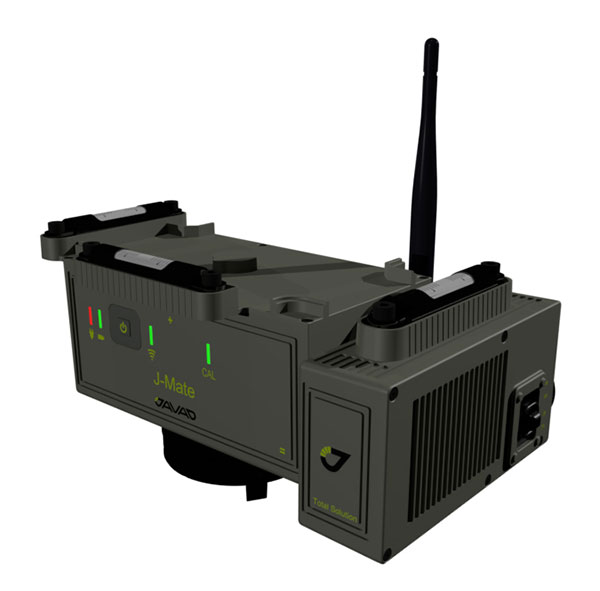
The J-Mate measurement module combines conventional measurement via laser scanning and photographic imagery with the multi-constellation location accuracy of the Triumph-LS receiver. It utilizes precision horizontal and vertical encoders for angular measurement, while the high-definition camera and laser module combine to locate the USB-powered target for accurate measurements. The target rests on top of the receiver and lights up for better visibility to the camera and sensor. The lighting power comes through the USB cord connected to the receiver. Coupled with the onboard data collector screen of the Triumph-LS, operation of the module is done visually with the LS mounted on top of the module or remotely on the J-Pod pole used for GNSS data collection. The module and software is also designed to be an efficient staking application.
The Trimble R10 Model 2 GNSS System is designed to help surveyors work more effectively by enabling reliable, fast and accurate data collection in the field. Enhancements in Model 2 include a custom Trimble survey GNSS ASIC with 672 GNSS channels including GPS, GLONASS, BeiDou, Galileo, QZSS and IRNSS as well as the full range of SBAS. It also will support planned GNSS signals. It has improved reliability against interference and spoofed signals, improved power management by 33 percent, and increased internal memory (6 GB) to store more than 10 years of raw observations. Support for Android and iOS platforms allow field crews to use their own mobile devices. The Trimble R10 Model 2 supports the recently released Trimble TSC7 controller and Trimble Access 2018 field software.
The TerraStar-C PRO correction service provides multi-constellation support, including GPS, GLONASS, Galileo and BeiDou. Combined with NovAtel’s OEM7 positioning technology, TerraStar-C PRO cuts initial convergence times by nearly 60 percent and offers 40 percent better horizontal accuracy than the current TerraStar-C service. In challenging signal conditions, it offers multipath, shading, interference and scintillation. High-rate TerraStar-C PRO corrections provide reconvergence in less than 60 seconds following brief GNSS signal interruptions. Corrections are generated using TerraStar’s proprietary global network of more than 100 GNSS reference stations. The data is delivered worldwide through overlapping geostationary satellites directly to a NovAtel receiver or via cellular IP network.
The C3UBE Command Center enables unmanned beyond-visual-line-of-sight (BVLOS) data collection and near real-time data streaming from almost any point within any critical infrastructure network. The mobile command and distribution center allows for the flight of unmanned aerial systems and is designed to not only allow AviSight to reach the maximum BVLOS distances permitted today, but also to expand its range for UAS operations as limits increase in the national airspace. In addition, it enables near-real-time transmission of data and imagery, which can be disseminated live to anywhere in the world via its proprietary distribution network located at Switch’s Tier 4 data center. It is aimed at the oil, gas, power, transportation and telecommunications sectors.
SimActive has updated its Correlator3D end-to-end photogrammetry software to include tools for users to generate precise statistics on mining activities, with improved volumetric calculation. The integrated tools allow users to generate precise statistics on mining activities. The Correlator3D software performs aerial triangulation and produces dense digital surface models, digital terrain models, point clouds, orthomosaics and vectorized 3D features. Applications like mineral extraction monitoring can be done seamlessly within the software. Users can process raw drone data, produce point clouds and DSMs, and perform volumetric calculations in the same Correlator3D workflow.
The improved TruPulse 360 laser features LTI’s TruVector 360° Compass Technology. The rangefinder measures slope distance, inclination and azimuth; instantly calculates horizontal and vertical distances; and calculates 3D missing line values. The enhanced device offers 33 percent increased distance accuracy, 25 percent better target acquisition and a higher azimuth accuracy of 0.5° root mean squared (RMS). Other features include reflectorless technology that enables data capture to any surface type; advanced targeting modes to achieve accurate, repeatable results of the intended target; seven-power superior optics technology that displays all measured and calculated solutions; and smart technology that recognizes adverse measurement conditions and prompts recalibration. Uses include forestry, utilities, construction and GIS mapping.
Synthetic aperture radar imagery from Maxar’s MDA RADARSAT-2 satellite is now available to SecureWatch subscribers. SecureWatch is DigitalGlobe’s powerful, cloud-based geospatial intelligence platform. The service has added the radar imagery to its high-resolution optical imagery, enabling defense and intelligence analysts to deliver actionable insights to decision makers regardless of weather and light conditions. The satellite will refresh hundreds of global sites on a weekly basis using a wide-ultra-fine format (3-meter resolution, 50-kilometer scene width). RADARSAT-2 imagery allows users to observe features and changes that go undetected using other imaging techniques, and provides day and night coverage regardless of weather. SecureWatch users can access timely RADARSAT-2 imagery using current subscription plans. When combined with 30-cm optical imagery, analysts will have a powerful and reliable toolset to make decisions with confidence.
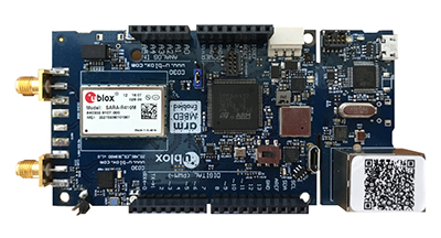
U-blox has introduced a toolset comprising the u-track software and the C030-R410M application board. The toolset is a rapid-prototyping platform that lets product designers test and optimize the position accuracy and power consumption of wireless location tracking applications that use LTE-M and NB-IoT cellular networks, as well as GNSS technology. The toolset targets product engineers working on battery-powered applications such as sport, people and asset trackers. An increasing number of battery-powered consumer and industrial products feature integrated GNSS receivers. These products include virtual reality headsets, smartwatches and devices to track elderly people, containers or parcels. With the ongoing roll-out of low power wide-area cellular networks (LPWAN) such as LTE-M and NB-IoT technologies around the world and the extremely low power consumption they enable, the range of use cases for wireless location trackers is expected to expand further. The u-track software runs from embedded firmware on the new u-blox C030-R410M application board. The board, specifically designed to rapidly prototype applications for the internet of things (IoT), includes an ultra-small, low-power u-blox ZOE-M8B GNSS receiver and a size-optimized SARA-R410M LTE-M/NB-IoT cellular communication module, and u-track includes a PC software application that lets users log, retrieve, and visualize power consumption, accuracy, and other important values, such as the GNSS time to first fix.
Add-on to AT&T Fleet Complete platform or for separate use
Photo: AT&T
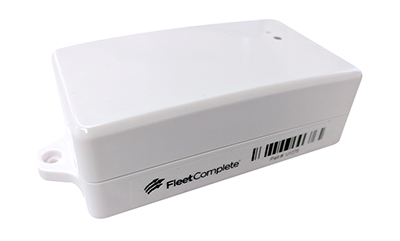
The new GPS Asset Tracker One (AT1) from AT&T and Fleet Complete can track transportation as well as agriculture, food services, pharmaceuticals and emergency services. Users can monitor their assets through the Fleet Complete mobile app. Besides tracking location in near real-time, it also captures humidity, temperature, light exposure and more. AT&T’s nationwide LTE-M network is designed for devices that require low-cost, extended battery life, coverage underground and inside buildings, and carrier-grade security. Two high-capacity Lithium AA batteries power the AT1. They can last up to five years with a once-a-day use.
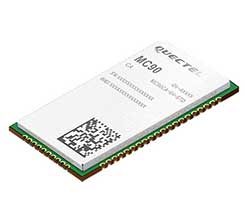
The MC90 is a quad-band GSM/GPRS/GNSS/Wi-Fi module that supports hybrid positioning technologies including GNSS, Cell ID and Wi-Fi aided positioning. It integrates the multi-GNSS system, including GPS, GLONASS, Galileo and QZSS, which makes it suitable for urban areas with high-rise buildings and complex environments. The MC90 also adopts Wi-Fi hotspot positioning technology for blind spots and satellite coverage. It integrates multi-aiding positioning technologies to offer customers with optimized GNSS performance. It also supports EPO technology, which provides predicted Extended Prediction Orbit to speed up TTFF without the need of an extra server. The MC90 features a compact design and lower power consumption, and supports dual SIM single standby function.
TomTom will offer free maps and traffic tiles on its mobile software developer kit (SDK) in both Android and iOS. With global coverage, the Mobile Maps SDKs and its free map tiles will guide developers of mobility and ride-sharing apps. The TomTom Maps APIs (application programming interfaces) also play a role in the internet of things, where traffic data is needed to enable self-driving cars and smart city planning.
MAGNET Inspect is designed for UAV data collection. (Photo: Topcon)
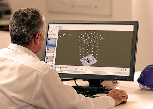
MAGNET Inspect software is designed to facilitate the data-processing workflow for UAV (unmanned aerial vehicle) infrastructure inspection by efficiently managing large UAV data sets to create inspection reports. It allows operators to visually navigate UAV photos, aligning 3D reality meshes with raw georeferenced images in one location and filtering them based on selected criteria including field of view. When combined with Intel Falcon 8+ Drone – Topcon Edition and Topcon ContextCapture, powered by Bentley Systems, the software enables operators to navigate, annotate and create reports with inspection photos, creating a strong end-to-end inspection workflow.
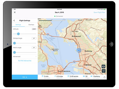
Site Scan Esri Edition is a custom version of the Site Scan iOS app for drone flight planning and data capture that works seamlessly with Esri’s ArcGIS Online and Drone2Map for ArcGIS. The Site Scan Esri Edition app complements Esri’s Drone2Map for ArcGIS software by providing full drone project mission planning and a simple workflow for transferring drone captured data into Esri ArcGIS. Users will be able to connect to ArcGIS Online with an Esri sign-in. The app will allow users to directly use Esri data layers from ArcGIS Online as base and reference data for their drone flight planning mission. Esri customers can use any drone supported by Site Scan, including a variety of DJI drones. Site Scan also supports a custom version of the new Yuneec H520 commercial drone by 3D, which is based on the Dronecode PX4 software and designed to be an open and secure drone option for use on U.S. government projects.
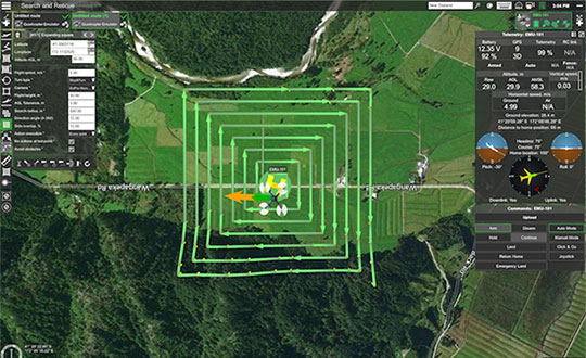
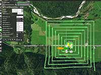
UAS mission-planning software company UgCS has joined with disaster response expert Airborne Response to develop a comprehensive search capability for drones. The search-pattern software, a new feature of the UgCS platform, allows remote pilots to more effectively conduct search-and-rescue operations. Customizable search patterns such as the “expanding square” and “creeping line” can be deployed. Based on the flight altitude input by the operator, the UgCS software will automatically calculate the course heading and track spacing necessary to provide the prescribed coverage area for a search target. UgCS software allows central management of all types and manufacturers of unmanned vehicles, enabling a user to control one or a fleet of drones on a single mission in multi-operator mode and multi-platform environments. Airborne Response will offer the UgCS mission planning software and associated training to public safety and emergency response professionals throughout the U.S.
The Mavic 2 Pro is designed for professionals, aerial photographers and content creators. With a folding design, the Mavic 2 is a powerful platform with new gimbal-stabilized cameras and advanced intelligent features like Hyperlapse and ActiveTrack for easier and more dynamic storytelling. Flight time is 31 minutes. Co-engineered in partnership with Hasselblad, the Mavic 2 Pro houses a 1-inch CMOS sensor with a 10-bit Dlog-M color profile. It can capture 20-megapixel aerial shots with utmost color accuracy using the Hasselblad Natural Color Solution (HNCS) technology, while an adjustable aperture from f/2.8-f/11 provides control across a wide variety of lighting conditions.
Completion of the transaction was subject to regulatory approvals, including a filing to the Committee on Foreign Investment in the United States (CFIUS), which have now been obtained.
AutonomouStuff will be a fully owned subsidiary of Hexagon and operate within Hexagon’s Positioning Intelligence division.
“Combined with Hexagon PI’s leadership in high accuracy, functionally-safe and high-integrity positioning technology, the addition of AutonomouStuff and their offerings is helping our customers to accelerate the development of more comprehensive Autonomous X solutions,” said Michael Ritter, president and CEO of Hexagon PI. “Our expanded capabilities will allow Hexagon PI to meet the industry’s ever growing demand for more robust autonomy solutions.”
Hexagon PI has been an important technology provider to AutonomouStuff for several years, and the two organizations have worked closely together to serve common customers and collaborate on important industry events. As the division grows, AutonomouStuff will continue to function as an independent brand within Hexagon PI.
Founded in 2010, U.S.-based AutonomouStuff is pioneering solutions and platforms for autonomous vehicle development, robotics and data intelligence innovation. Its platforms, which use an expansive portfolio of technologies, are deployed in pilot programs worldwide — representing thousands of customers in the automotive and technology sectors across the globe, AutonomouStuff said.
“The combined entities now provide the fuel and support for exponential growth while affording us the ability to make continued advances in the mobility space,” said Bobby Hambrick, founder and CEO, AutonomouStuff. “I’m very excited for our shared future.”
In 2017, AutonomouStuff generated sales of 45 MUSD, with good profitability, Hexagon said. The AutonomouStuff transaction purchase price will not be publicly disclosed because it is considered insignificant relative to Hexagon’s market capitalization.
The income statement during the third quarter of 2018 will be impacted by -25 MEUR, related to impairment of overlapping technologies, transaction costs and a reduction in workforce. During the third quarter 2018 Hexagon also divested its shares in Bimobject which resulted in a capital gain of 22 MEUR.
Overall, the net impact of one-off items on the income statement in the third quarter 2018 will be approximately -3 MEUR, Hexagon said.
Rx Networks Inc., a mobile location technology and services company, has announced an update of its location.io platform to provide GNSS assistance data to enable better positioning in internet of things (IoT) devices.
The company has updated its location.io HTTP interface to provide real-time GNSS ephemeris data with a reduced payload, a smaller predicted GNSS ephemeris client while maintaining full featured accuracy.
Rx Networks is demonstrating location.io at its booth at ION GNSS+, being held this week in Miami.
The location.io HTTP interface is now leaner and requires fewer requests and less data. In providing an interface for IoT devices, specifically, Rx Networks extends the delivery of their reliable and accurate assistance data to new and emerging use cases.
“Rx Networks is a proactive company endeavoring to provide excellent solutions and services for our customers,” said John Carley, director of sales and product strategy at Rx Networks. “By adding another use-case focused interface, we are able help customers create top-quality solutions targeted for their customer needs. By adding another interface designed for specific use cases, we help our customers create top-quality solutions targeted for their customer needs. Especially in the areas of smaller processors, longer product life time and lower battery consumption.”
location.io includes technologies already used by more than 1 billion smartphones, laptops and wearables worldwide. Specific components are:
Real-time GNSS assistance. The real-time assistance service is designed to work with all popular location servers such as Ericsson, TCS, ZTE, and Qualcomm. Rx Networks also offers RINEX files and a generic HTTP interface for independent access to the assistance data. It supports over five constellations, including GPS, GLONASS, Beidou, Galileo, QZSS and SBAS. RT-GNSS assistance can now be filtered by location or Cell ID to provide only Satellites in View.
Predicted GNSS assistance. The predicted service provide seed data that enable client devices such as smartphones, laptops, and wearables, to generate up to 14 days of extended ephemeris for fast and sensitive GNSS fixes. Predicted GNSS assistance support GPS, GLONASS, BeiDou and Galileo, and has been updated to have a smaller footprint, use less resources and support OSs and RTOSs.
All location.io services are delivered from Rx Networks’ geo-redundant and cloud-based service delivery network, via a lean API ensuring a 99.999 percent service level availability.
NTRIP Data. Rx Networks has also added NTRIP-formatted data services to location.io. Customers can now choose from a variety of data formats, including Rx Networks proprietary format, NTRIP, LPP, RRLP, proprietary real-time, IoT-optimized and a few custom formats.
Observation data from our multiband multi-constellation global reference network is now available in NTRIP format, and customers are already on board.
High availability is assured with geographically redundant secure NTRIP casters, the company said. The innovative High Accuracy Assistance Service (HAAS) product will also be available in RTCM format via NTRIP casters.
With the addition of RTCM formatted data via an NTRIP data feed, Rx Networks continues to expand its constellation support with the largest variety of terrestrial delivery mechanisms. The solution architecture includes an NTRIP server, caster and client, providing a complete solution.
“Our customers love the reliability and plug-and-play convenience of our NTRIP service,” said Brian Marciniak, head of business development at Rx Networks. “With Rx Networks’ expanded reference network, secure NTRIP observations and real-time data, we are enabling our customers to expand their businesses in exciting new ways.”
location.io includes technologies already in use by more than 1 billion smartphones, laptops and wearables worldwide.
All location.io services are delivered from Rx Networks’ geo-redundant and cloud based service delivery network.
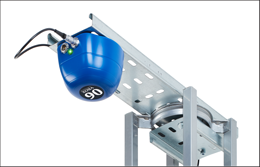
VBOX indoor positioning beacon atop a car. (Photo: Racelogic)
Racelogic demonstrated a new VBOX solution for accurate position and velocity in the absence of any GNSS signals, such as indoors, at the ION GNSS+ exhibition.
VBOX data acquisition systems are used for measuring the speed and position of a moving vehicle. Based on a range of high-performance GPS receivers, VBOX dataloggers can record high-accuracy GPS speed measurements, distance, acceleration, braking distance, heading, slip angle, lap times, position, cornering forces and more.
VBOX indoor positioning beacon in a bracket. (Photo: Racelogic)
The new VBOX Indoor Positioning System consists of a network of fixed beacons communicating with a small receiver mounted on the roof of the vehicle, which is connected to an existing VBOX. The receiver computes its position 100 times a second to around 5 centimeters real-mean-squared (RMS) accuracy. The system can be used on its own or with an internal inertial measurement unit (IMU) to improve the velocity accuracy.
Racelogic engineers worked closely with its VBOX customers to develop a solution that allows the same test equipment and software that has traditionally been limited to outdoor use to be used anywhere that satellites coverage is limited or completely unavailable, such as in a parking garage.
Beacon placement. (Image: Racelogic)
The VBOX seamlessly switches between outdoors and indoors, allowing testing to continue whatever the environment and VBOX users to make use of their original hardware and software applications.
Racelogic will demonstrate the system at the ION GNSS+ exhibition at the Hyatt Regency in Miami, Sept. 26-27. Racelogic will also be showcasing its new, upgraded version of SatGen simulation software for the Labsat 3 Wideband simulator.
HERE Technologies and Altair Semiconductor are partnering to integrate HERE tracking and positioning software into Altair’s ALT1250 dual-mode LTE Cat-M1/NB-IoT chipset. This will enable HERE customers, system integrators and tracking device manufacturers to significantly reduce device time to market and provide hardware-based security.
The two companies plan to reduce overall power consumption of an end-to-end tracker application by optimizing the way the device communicates with the cloud.
The ALT1250 includes a GNSS receiver, an RF front-end supporting all commercial LTE bands within a single hardware design, a hardware-based security framework and an internal application MCU subsystem.
The integration of HERE tracking and positioning software means the chipset will be able to locate itself using the strength of cellular signals, even when it is not possible to obtain a GNSS fix.
The chipset can take advantage of the ability of HERE to provide online and offline positioning based on its database of cellular towers.
Ravenswood Solutions has been awarded a $1.3 million contract to support the U.S. Army Joint Modernization Command (JMC) during an exercise this fall at Fort Bliss, Texas, and White Sands Missile Range, New Mexico.
Ravenswood will provide support via its GPS-based Mobile Ground Truth System (MGTS) — also known as FlexTrain. The rapidly deployable system tracks individual vehicles, units and participants during exercises. Using the system, unit leaders can monitor events in real time and replay scenarios.
The results are real-time casualty assessments, a record of factors affecting capabilities and operations.
Ravenswood has trained more than 130,000 troops with FlexTrain. The MGTS has been successfully deployed in 60 x 80 kilometers areas and can track thousands of players, the company said.
A new GPS + IRNSS module is being developed by Indian firm Ramakrishna Electro Component (REC) in partnership with STMicroelectronics and Shanghai Mobiletek, according to press reports.
The module will rely heavily on the Indian navigation satellite constellation IRNSS (also known as NaVIC), REC Managing Director Shivang Luthra told reporters at an event in New Delhi.
“There have been dependency of imported GPS module which use the U.S., European or Russian satellites,” Luthra said. “We have developed a GPS module, Utraq, that will mainly use the Indian satellites for GPS navigation.”
The module will be produced at a Shanghai Mobiletek factory in China, and the chips will be made by STMicroelectronics. REC owns the Utraq module and will roll it out in October for use in automotive end products. REC says the low cost of the chip compared to imports will make trackers more affordable in India.
The Indian government has mandated use of vehicle location tracking devices and one or more emergency buttons in public transportation vehicles; the mandate took effect April 1.
Utraq will be offered in two models: the L110 GNSS is a compact NavIC module, while the L100 GNSS module is a smaller-sized (patch on top) IRNSS module. Both modules can be used for tasks other than tracking, such as ranging, command, control and timing, and fo marine, aerial and terrestrial navigation.
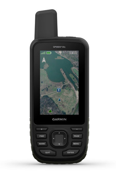
Garmin International is offering a new outdoor GPS handheld that can log raw measurements in RINEX form, the GPSMAP 66.
“We’ve had good success achieving carrier-phase ambiguity resolution with the unit, and I suspect many readers will be interested in this feature from a purpose-built device,” said Jared Bancroft, GNSS sensors & algorithms, Garmin, in an email to GPS World. “We’ve observed accuracies down better than 30 centimeters.”
The GPSMAP 66 is a premium outdoor handheld with expanded wireless connectivity, direct-to-device access to BirdsEye satellite imagery and a 3-inch sunlight-readable color display. The handheld comes in two models, the GPSMAP 66s and GPSMAP 66st. The latter offers preloaded topographic maps for U.S. and Canada.
Professionals and serious GPS enthusiasts will appreciate the inclusion of RINEX data logging, which allows for sub-meter accuracy of GPS position after post processing, Garmin stated in a press release.
“The GPSMAP 66st builds on the GPSMAP series heritage by adding new and requested features like a bigger screen, weather forecasting and easy direct-to-device access to satellite imagery,” said Dan Bartel, Garmin vice president of global consumer sales. “Between multi-GNSS network support and connectivity to the new Garmin Explore app, the new GPSMAP 66s and the GPSMAP 66st are reliable companions for any adventure.”
The handheld can receive weather updates for real-time forecast information by being paired via Bluetooth to a compatible mobile device. It will also provide predictive maps for temperature and wind speed/direction, as well as live weather radar.
Other new GPSMAP 66s/st connected features include Geocaching Live and compatibility to the Connect IQ platform, giving users access to 9 million trails through the preloaded Wikiloc app. The devices all pair with the inReach Mini, allowing the user to send and receive messages directly on their 66s/st device via the Mini.
Between the multi-GNSS satellite support and altimeter, barometer and compass sensor capabilities, the GPSMAP 66s/st will track an entire journey. The handheld devices have 16 hours of battery life in full GPS mode and can track the user’s position for up to one week using Expedition mode on a single set of AA batteries, the company said.
The devices include an LED flashlight and SOS beacon that can be used to signal for help. It is built to military standards for thermal, shock and water performance (MIL-STD-810G).
U-blox is collaborating with LynQ, which developed a location tracker that doesn’t use cellphones, networks, apps or monthly fees. By syncing up the devices before heading out, group members can find each other within a five-mile radius and link up again.
LynQ surpassed its fundraising target on the Indiegogo crowdfunding platform, raising more than $1.5 million, and is now on pre-sale.
The device uses the u-blox CAM-M8Q GNSS receiver, a GPS/GLONASS/BeiDou positioning module with an embedded antenna. With its slim size of 9.6 x 14 x 1.95 millimeters, it is easy to integrate it into handheld devices, u-blox said.
The first generation of the weather-proof tracker uses long-range, low-power radio frequencies to connect devices. Up to 12 people can join a group, split up, and use the only button on the clip-on device to toggle through the group members and find out in which direction and how far away each one is.
LynQ’s crowdfunding success shows the extent to which the company’s founders uncovered an unmet demand on the market. While smartphone-based solutions to locate friends and family, for instance in a crowd, abound, they are limited by the availability of mobile network reception.
LynQ’s location tracker helps friends regroup outdoors or at crowded events, parents keep an eye on their children, and caregivers watch over the safety of people with special needs, elderly family members, or loved ones suffering from diseases such as Alzheimer’s.
The tracker has been field-tested on numerous continents and in most topographies and use cases.
“We found the u blox CAM-M8Q to be the best solution for us to achieve the requirements our use cases demand,” said Drew Lauter, COO at LynQ. “We’re extremely price sensitive, yet we need a highly dependable GPS module; u-blox worked closely with us to deliver that.”
For u blox, accompanying LynQ in the development of its product has been an exciting adventure, said Suresh Ram, president of u-blox America. “We’re thrilled to see how well their idea has been received by the public and look forward to our continued collaboration in the future.”