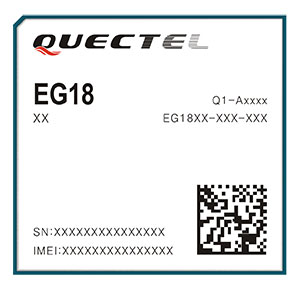
Quectel Wireless Solutions, a global supplier of internet of things (IoT) modules, has launched the EG18, an LTE Category 18, high-speed module that offers 1.2Gbps downlink and 150Mbps uplink peak rates.
EG18 module. (Photo: Quectel)
The EG18 supports Qualcomm IZat location technology Gen8C Lite (GPS, GLONASS, BeiDou, Galileo and QZSS). The integrated GNSS greatly simplifies product design, and provides quicker, more accurate and more dependable positioning capability, Quectel said.
Based on Qualcomm’s SDX20 chipset and fully compliant with 3GPP R12 specification, EG18 supports wireless technologies such as carrier aggregation (CA), 4×4 multiple-input multiple-output (MIMO) technology and 256QAM.
Quectel EG18 is a series of LTE Advanced modules optimized specially for M2M and IoT applications which support industrial operating temperature range of -40 to 85˚C.
The EG18 is designed for ultra-high-speed industrial routers, in-vehicle video surveillance systems, cloud-based 4K IP-cameras and other applications that require very high throughput and low latency.
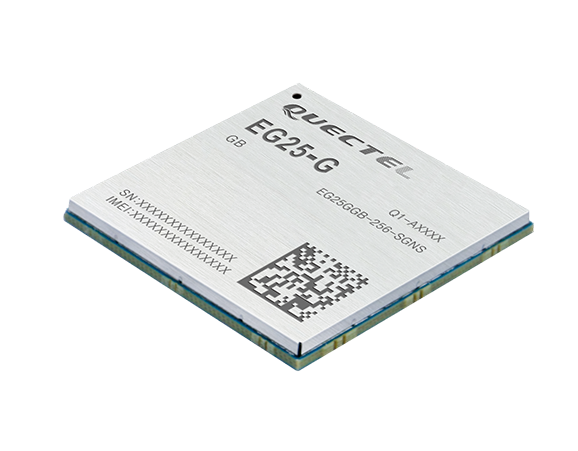
EG25-G module. (Photo: Quectel)
EG25-G module. Quectel also launched an LTE Cat 4 module to provide global connectivity on up to 30 bands with LTE, 3G and 2G coverage all from a single SKU. This “all-in-one” module EG25-G is designed to improve the efficiency of global IoT deployment at optimized cost.
EG25-G is the latest addition to Quectel’s comprehensive LTE portfolio based on Qualcomm MDM9x07 chipset. Adopting the 3GPP Release 11 LTE technology, it delivers 150 Mbps downlink and 50 Mbps uplink peak data rates, with an optional GNSS receiver including GPS, GLONASS, BeiDou, Galileo and QZSS to provide quick and accurate positioning, the company said.
The new module supports FDD LTE frequency bands of B1/B2/B3/B4/B5/B7/B8/B12/B13/B18/B19/B20/B25/B26/B28, TDD LTE bands of B38/B39/B40/B41, WCDMA bands of B1/B2/B4/B5/B6/B8/B19 and quad-band GSM/EDGE. This ensures devices with EG25-G inside can operate on networks of major global carriers like AT&T, Verizon, Telstra, Vodafone and T-Mobile. The EG25-G supports multi-carrier switch by detecting (U)SIM card.
Designed in a compact LGA form factor measuring 29.0×32.0×2.4 mm, EG25-G is pin-compatible with Quectel’s EC2X family, allowing flexible migration. It also offers Mini PCIe form factor with built-in sim card holder to provide a better plug-and-play experience.
“A growing number of today’s IoT developers tend to design and manufacture devices that can operate globally with a single hardware design. Our EG25-G was created to address such needs,” said Delbert Sun, Quectel product and marketing director. “We are pleased to see that customers will achieve simplified production and testing processes, and save distribution costs due to the need for just one single SKU.”
EG25-G has a rich set of Internet protocols, industry-standard interfaces, abundant functionalities and extended life cycle, and is designed for verticals including industrial routers, industrial PDA and video surveillance.
This announced version of Qualcomm Technologies’ precise positioning framework supports single-frequency GNSS utilizing real-time kinematic (RTK) technology based on the GNSS receiver built into Qualcomm Snapdragon LTE modems and Qianxun SI’s precise positioning technology — all integrated in an automotive-grade LTE module provided by Quectel.
Using Qualcomm 3D dead-reckoning technology, the precise-positioning framework will enable automakers with a comprehensive 3D navigation solution combining multi-constellation GNSS precise positioning, inertial measurement units and other sensors to support next-generation vehicle capabilities, the companies said.
Capabilities include high-performance connected navigation as well as LTE-V2X vehicle-to-everything communications (also referred to as C-V2X PC5 across the globe) for enhanced road safety, improved traffic efficiency and autonomous driving.
Qualcomm Technologies’ precise positioning framework is designed to facilitate open-sky positioning performance from up to 3 meters to less than 1 meter, supporting lane-level positioning and potentially achieving accurate locations from a centimeter to a few decimeters when combined with select third-party GNSS correction services.
This framework is also designed to support a safer and convenient automated driving experiences (level 2 and above), as well as LTE-V2X applications based on positioning, velocity and heading information. Integrated into telematics modules based on the Snapdragon LTE modems, the precise positioning framework supports a cost-effective solution for automakers already including cellular connectivity into their vehicles.
“The efforts with Qualcomm Technologies and Quectel not only assists automakers in addressing the cost and complexities of integrated precision positioning services, but it also aids in creating hardware and service standards for the industry to promote this capability as a public service in the field of connected cars,” said Jinpei Chen, CEO of Qianxun SI. “We look forward to working with Qualcomm Technologies and Quectel to help deliver a solution for higher accuracy and positioning, particularly in dense environments such as in China.”
“In efforts to meet the positioning service requirements of mainstream automakers and Tier 1 suppliers, we felt that working with technology leaders like Qualcomm Technologies and Qianxun SI would be the best to deliver an intelligent, cost-effective and high-quality telematics module,” said Penghe Qian, CEO of Quectel. “The AG35 is our newest generation of automotive-grade modules that enables 4G connectivity and lane level positioning simultaneously, allowing the adoption of LTE-V2X and HD Map technologies on a broad scale.”
“The automotive industry is becoming increasingly dependent on high performance positioning technologies to support connected navigation, safety services and vehicle autonomy,” said Nakul Duggal, vice president of product management, Qualcomm Technologies, Inc. “At Qualcomm Technologies, our proven positioning and system integration capabilities, along with Quectel and Qianxun SI’s solutions, can provide customers with cost-effective precise positioning solutions. We are pleased to be working with China’s leading technology companies like Quectel and Qianxun SI to advance next-generation automotive capabilities that will drive the automotive industry forward.”
EuroTube is Europe’s first testing ground for high-speed vacuum maglev transportation.
In May, a WingtraOne drone conducted a topographic survey of a construction site where a EuroTube vacuum high-speed test track will be built.
The futuristic project is the European answer to its American counterpart Hyperloop of the SpaceX and Elon Musk fame. The EuroTube project plans to provide a 3-kilometer-long vacuum tube to developers of pod technologies for testing.
The Eurotube test infrastructure for high-speed vacuum transportation will provide an environment free of air resistance to test “pods”, or cars, that can be accelerated to speeds as high as the Boeing 747 in flight. (Photo: EuroTube)
The project proved to be surprisingly challenging from the very beginning. First, the team had to find a long, flat stretch of land for EuroTube’s construction in Switzerland, a country famous for its mountains.
And just as the right location was found in the canton of Valais, another challenge came along. How to survey such a complicated site surrounded with mountains, water bodies, forests and railway tracks? Luckily, the fellow Swiss company Wingtra already had a solution — the vertical-take-off-and-landing (VTOL) drone WingtraOne.
After spending months in research and development of prototypes, the team at EuroTube selected the stretch of land in the Valais region of Switzerland as its candidate location. The chosen construction site is located next to railways tracks. A few water bodies, forests and ditches flank the other side of the construction site, making available a mere 3-meter-wide piece of land for take-off and landing of the drone.
Fortunately, the WingtraOne’s VTOL capabilities were designed with exactly these kind of constraints. But why choose such a peculiar construction site in the first place?
Bringing Europe’s transportation system to 21st century
The answer lies in the technology behind the EuroTube itself. One of the main limitations in speeding objects on ground is the high air resistance, also called drag (drag is a type of friction force acting opposite to the relative motion of any object). By maintaining a low-pressure environment or even a vacuum, this air resistance can be lowered drastically, and hence objects can be accelerated to high speeds.
Technologies such as the EuroTube provide this vacuum environment inside a long tube. Within such tubes, cars called “pods” can be accelerated to speeds as high as 800 km/h, meaning a journey between Zurich and Paris, which currently takes 4 to 6 hours, would be reduced to a mere half an hour. This is the vision driving the EuroTube project, which will provide a 3-kilometer-long vacuum tube to developers of pod technologies for testing.
Aerial surveying of the construction site
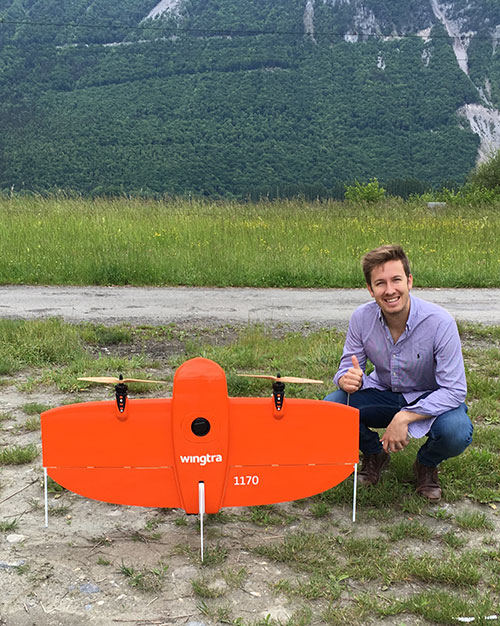
Gerard Güell, the construction director of EuroTube, at the construction site with the WingtraOne. (Photo: Wingtra)
Before the construction of the tube could begin, however, the EuroTube team needed to survey the construction site. Looking at solutions that would cut time and cost, Sascha Mark, the technical director at the EuroTube project, reached out to Wingtra in early May.
A partnership between Wingtra and EurtoTube was quickly formed where Wingtra would provide the WingtraOne as well as conduct the surveyof the construction site.
“For a cutting-edge research project involving significant infrastructure, time is of crucial importance,” Mark said. “We were looking at surveying solutions that can provide the dataset required for a construction site quickly without compromising on the accuracy. From this perspective, WingtraOne looked like a viable prospect.”
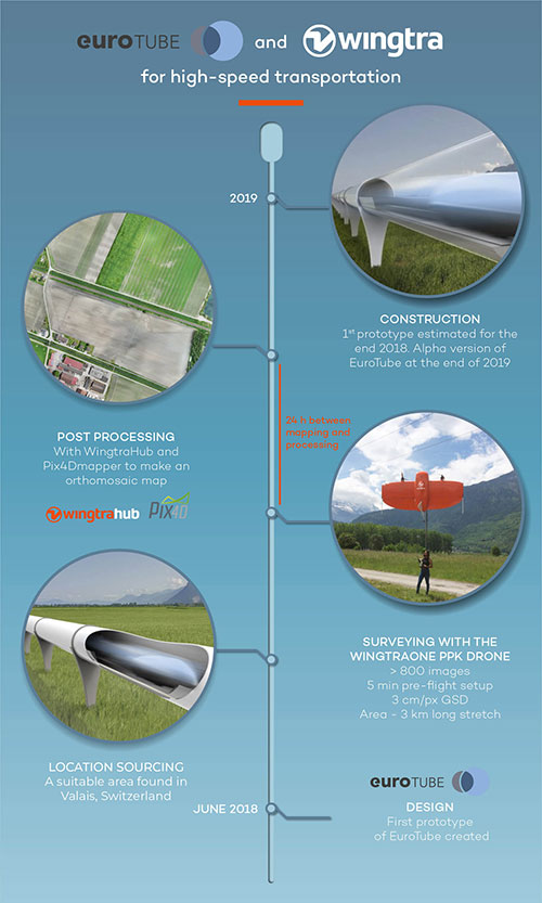
The survey was conducted on May 21 when Gerard Güell, the construction director at EuroTube, met Adyasha Dash from Wingtra on site. To survey the area quickly with high accuracy, a WingtraOne equipped with an RX1RII camera and post-processed kinematics (PPK) was chosen. As the survey required flights over a straight, flat piece of land, flight planning was done on site, and took less than 5 minutes for the setup.
The wind on site ranged from 2 m/s to 5 m/s. After letting the flight planning app WingtraPilot run a host of automatic pre-flight checks, the drone started its flight to collect aerial imagery at a ground sampling distance (GSD) of 3 cm/px. At the end of two consecutive flights taking less than an hour in total, the drone had collected a little more than 800 individual images.
“It was nearly effortless to conduct the aerial surveying with the WingtraOne,” Güell said. “All we had to do was to walk to the take-off area, double-check the survey area we wanted to cover on the flight planning app, and hit go.”
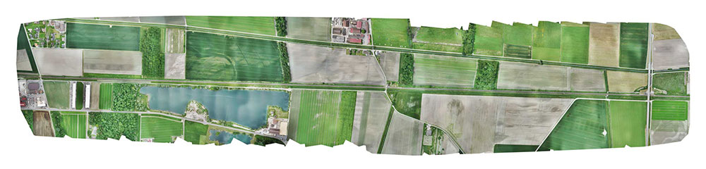
Final orthomosaic generated by the images collected by the WingtraOne: the 3-km long Eurotube will be constructed along the indicated area. (Image: Wingtra)
From aerial imagery to point cloud
Infographic: Wingtra
After two flights, the images were pre-processed with WingtraHub, a desktop app, to add geographical identification metadata to the images. PPK processing was also done in this step. The base file for PPK processing was obtained from Swisstopo, which monitors GNSS receivers at 30 permanent locations in Switzerland. These receivers form the modern-day reference points for positioning and surveying, and help enhance the geolocation information of the images in conjunction with the flight data (hence the name, post-processed kinematics). It took a little more than half an hour to pre-process the entire dataset.
The images with their accurate geolocation information were then uploaded to Pix4Dmapper to generate a point cloud of the site. All in all, it took less than 24 hours to go from data collection to point-cloud generation, without compromising on the quality of survey itself.
“We are pleased to say that the dataset gathered by the WingtraOne was precise enough to let the engineering office begin planning construction,” Mark said. “The generated point cloud has a vertical accuracy of 10 centimeters and horizontal accuracy of 3 centimeters. Thanks to the WingtraOne, we are now well on track on our timeline to begin construction.”
According to EuroTube’s scheduled timeline, a shorter prototype of the tube will be completed at the end of this year, and an alpha tube at the end of 2019. European research and development teams across institutes and universities can then start testing pod technologies to make ultra-high speed transportation systems a reality.
Adyasha Dash works as a software developer at Wingtra, where she focuses on developing safe flight control and planning algorithms. When she is not tinkering with drones, you can find her writing about the ethics of artificial intelligence and human machine interactions.
Steve Malkos of Google, and a GPS World contributor, will address the ION GNSS+ plenary session at the technical meeting and showcase, to be held Sept. 24-28 in Miami.
Malkos will address “Emergency Location Service in Android.” When emergency services get a call, they need to know the caller’s location to send help and save lives. More than 80 percent of calls to emergency services come from mobile phones, but locating these mobile callers can be a major issue.
Current emergency solutions rely on cell tower location (which can have a radius of several kilometers) and, in some countries (like the U.S. and Japan), on A-GNSS. But A-GNSS can fail with weak signal reception, in urban canyons and indoors.
Malkos will discuss how Emergency Location Service in Android is delivering more accurate location (computed from fusion of Wi-Fi, cell, GPS and sensors) to emergency services when an emergency call is detected.
Paul LaRocque
Also speaking is Paul E. LaRocque, Teledyne Optech‘s vice president of Special Projects. In his presentation, “A Lidar History: From Ship to Air to Space,” LaRocque will give a historical review of the airborne laser mapping systems that Teledyne Optech has designed and built over the years.
Optech has been active in laser radar systems beginning with marine lidars and later moving to airborne and spaceborne systems. Navigation has been an important subsystem in these developments, and its role will be described as part of this story.
LaRocque has been involved in the development of Optech’s lidar systems since the late 1980s. Dr. LaRocque was instrumental in the design of Optech’s airborne lidar bathymeters, airborne lidar terrain mappers (ALTM), and waveform digitizers, as well as other special lidars.
GIS specialists are much more than mapmakers. Make sure your organization and customers understand how spatial analytics can help them succeed.
By Adam Carnow
Most non-GIS users hear the term “G-I-S” and think “M-A-P.” That is, they think of GIS, and GIS practitioners, as mapmakers. Most GIS practitioners have unknowingly perpetuated this image. Ask any GIS practitioner what they do for a living and most will say, “I make maps;” however, the reality is that what they do for a living is help people make better decisions through the power of location. This is what I call location intelligence.
There is a tremendous growth opportunity for GIS in government across the enterprise. GIS was created to perform spatial analysis. GIS can often be underutilized because non-GIS users sometimes don’t understand the reach of spatial analysis and how it can help them. GIS practitioners need to market and evangelize the power of spatial analysis to help change that image.
Photo: rmnoa357/Shutterstock.com
You can break down location intelligence into six categories. As you move down this list, the value of the location intelligence increases:
Understanding Where. A map (could be paper or PDF, but should be an interactive web map) showing where the fire stations are located across a city.
Measuring Size, Shape and Distribution. A map showing the size, shape and distribution of wetlands across an area would help with wetland protection and preservation.
Determining How Places Are Related. Showing how certain soil types correspond to flood zones.
Finding the Best Locations and Paths
To find the best location for a new fire station, run a drive-time polygon process to show the coverage area for each fire station. The areas that are uncovered are where a new fire station is needed.
To find the best path for field inspectors: We have 50 inspections to do today and three inspectors. Divide the inspection locations among each inspector and create the most efficient route to get their work done.
Detecting and Quantifying Patterns. Crime analysts look at crime data to try to predict where the next one may occur and to help identify known perpetrators. (See also An inside look at fighting crime with GIS.)
Making Predictions. Modeling a watershed can allow for flood predictions based on anticipated rainfall.
Another way to help break the mapmaker image is to rebrand. Most staff in any organization use spreadsheets daily for a multitude of things that bring value to the organization – some say it’s the number one business intelligence (BI) tool.
There are GIS software tools that are as easy to use as a spreadsheet; in fact, you can use GIS inside of spreadsheets.
Wetlands map, Oregon’s Klamath Lake. (Map: USGS)
Even though spreadsheets are such a useful tool, you don’t see a Spreadsheet Department. Spreadsheet is just the name of the tool, so you don’t have, or name, a department for it. A department should be named based on the function, or value, it serves.
GIS should be thought of as BI with location data and spatial analysis, or location intelligence. A great way to get people to understand the real value and power of GIS is to rebrand your GIS department to something like Enterprise Location Intelligence.
One such example of this is Walgreens. As the drugstore chain’s GIS department became more strategic and tied to the analytics of the organization, the company rebranded it as Enterprise Location Intelligence.
If your organization has a BI group, they should consider reorganizing to put GIS with that BI group. I’m seeing real-world examples of this rebrand:
GIS job title changes to things like:
Data Analytics Manager
Content Delivery Manager
Business and Location Intelligence Manager
Reorganization putting GIS with BI: A major city has a Smart City initiative, and in response the city has reorganized its IT group — they now have a Data Analytics Group that consists of a BI team and their GIS team.
This rebrand, and expansion of the understanding of the true purpose and value of GIS, will not just help the organization realize more return on investment (ROI) for their GIS investment, it will help the GIS practitioners elevate their value to the organization and hence their careers.
What can you do? If you’re a GIS practitioner:
Explore rebranding your title and your GIS group as a start to changing your image from mapmaker to solution provider.
Evangelize the power of location intelligence. This is actually pretty easy to do. When someone asks for a map, ask them why they need it, probe to find out more about their project; you will probably uncover a need for spatial analysis.
Start to enable others in your organization to become GIS users via easy-to-use web maps and apps. As they use GIS, they will realize its full potential and seek to utilize it more often.
If you’re not a GIS practitioner, seek out your GIS team to learn more about their capabilities and how they can help you. And, become a GIS user, there are plenty of GIS tools available that are easy to learn and use.
This article originally appeared on Govloop.com and is reprinted with permission.
Adam Carnow is an Esri community evangelist and part of the GovLoop Featured Contributor program.
Dewberry, a privately held professional services firm, has been selected as a consultant to Civis Analytics to perform comprehensive data analytics, including flood hazard and property loss modeling and damage estimation, to support the city of Houston’s post-Hurricane Harvey recovery efforts.
Hurricane Harvey flooding in Houston. (Photo: FEMA)
The granular, structure-level understanding of this catastrophic flooding event will be critically important to the city’s efforts to catalog impacts and direct resources to the rebuilding and recovery efforts, Dewberry said.
The resulting data will be made accessible to authenticated city staff and non-profit organizations through the new Houston Estimation and Analysis of Loss (HEAL) platform. A cloud-based system that will be used in disaster mitigation planning, HEAL will aggregate data, analytics, tools and visualizations in a web-based environment available to city, state and federal officials and other stakeholders.
Hurricane Harvey flooding in Houston. (Photo: FEMA)
The data development effort featured a hindcast model of the historic Hurricane Harvey storm event, which dropped 51 inches of rainfall within the city of Houston and surrounding areas over five days in August.
The HEAL platform will provide the city with a comprehensive data collection and analytical architecture with the ability to calculate and report unmet needs at various levels, such as structure, parcel and census block.
The analytics will include extensive modeling to estimate flood depth and extent and the structural and contents losses created by it. Model validation will use a wide set of data from debris removal pickup locations, and community field data collection, to federal assistance information, as well as non-traditional sources such as social media videos.
Hurricane Harvey flooding in Houston. (Photo: FEMA)
For this complex project, Dewberry’s innovative approach has involved strong applications of science and engineering including meteorological data processing, 2D flood risk modeling, and damage assessment to replicate post-Harvey conditions in Houston.
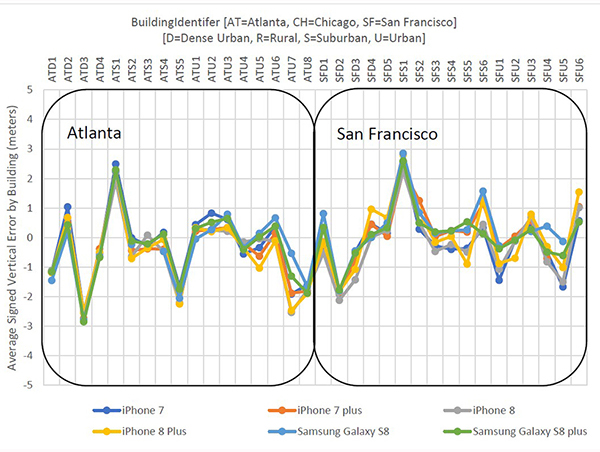
NextNav Results: Vertical accuracy delivered by various phone models using signals from an installed network of NextNav beacons. (Plots: NextNav, from ex parte FCC filing, Aug. 8)
According to NextNav, its altitude service delivered floor-level accuracy in 94 percent of test calls in recent blind industry tests commissioned by the Cellular Telephone Industry Association.
The Stage Z Tests were designed to develop a proposed Z-axis (vertical) metric for indoor wireless 9-1-1 calls, as required by the Federal Communications Commission (FCC).
NextNav’s Metropolitan Beacon System (MBS)-based services enable mobile phones and other devices to reliably determine their location and timing in indoor and urban environments where GPS signals cannot be received, the company said. NextNav’s 3D location services include accurate horizontal positioning, floor-level altitude precision, and context and visualization applications.
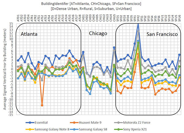
Polaris Results: Vertical accuracy (Plots: Next Nav, from ex party FCC filing, Aug. 9)
Delivered over a managed network on the licensed spectrum with carrier-grade dependability and metropolitan-wide coverage, NextNav’s services are designed for public safety applications, E911 and critical infrastructure as well as the multitude of consumer, internet of things and commercial applications that require reliable indoor 3D location or precision timing.
According to NextNav, the Stage Z Tests evaluated the ability of various technologies to accurately locate mobile 911 callers in the vertical dimension in challenging indoor environments spread across an entire metropolitan area. The tests were conducted using popular off-the-shelf iOS and Android devices running a software client provided by NextNav. The tests included more than 70,000 emergency-style calls generating altitude fixes from more than 200 different test locations.
“Our ability to deliver floor-level height accuracy has the potential to speed up emergency response time and save lives,” said Ganesh Pattabiraman, co-founder and CEO of NextNav. “The ability to precisely locate the exact floor is a significant breakthrough for wireless 9-1-1 location technologies.”
PCTEL Inc. will demonstrate its next generation of multi-band, multi-network 4G LTE antennas at InnoTrans 2018 for the transit and rail industries, which takes place Sept. 18-21 in Berlin.
PCTEL’s new Trooper II and Coach II dual-carrier antenna platforms are designed to meet the requirements of increasingly complex RF communication systems in transportation applications.
The Trooper II antenna. (Photo: PCTEL)
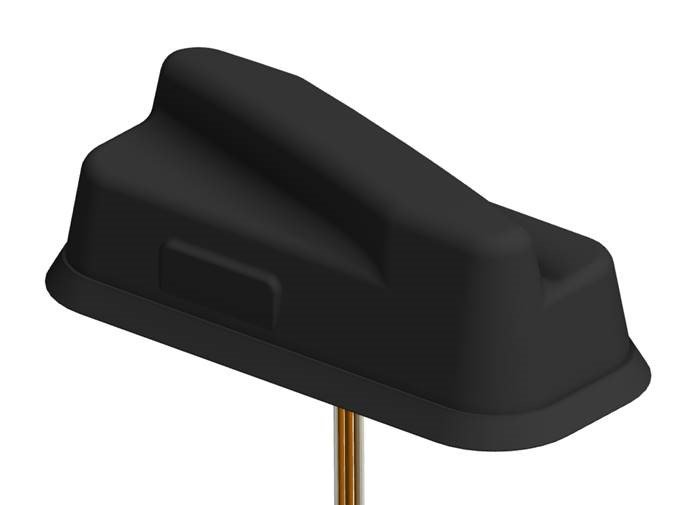
Both Trooper II and Coach II antennas feature four 4G LTE antenna elements, and four 802.11ac Wi-Fi MIMO elements compatible with the world’s leading multi-network cellular routers.
The antennas support carrier aggregation for high-speed data transmissions in dense RF environments, such as transit depots and rail stations.
They also incorporate PCTEL’s proprietary high-rejection multi-GNSS technology for high precision tracking and asset management. Both platforms are housed in attractive low-profile housings and can be easily installed on all types of mass transit vehicles, or even fixed surfaces, the company said.
“PCTEL has a strong portfolio of products for rail and mass transit applications,” said Rishi Bharadwaj, PCTEL’s COO. “Our products have been qualified and deployed by major railroad equipment manufacturers and operators for over a decade. We are excited to showcase our industry-leading technology and capabilities at InnoTrans.
“High-performance antennas play a crucial role in the implementation of wireless technologies to improve safety and operational efficiency,” Bharadwaj said. “PCTEL’s innovative MIMO antenna technology also enables transit operators to deliver a better passenger experience through more reliable high-speed internet access.”
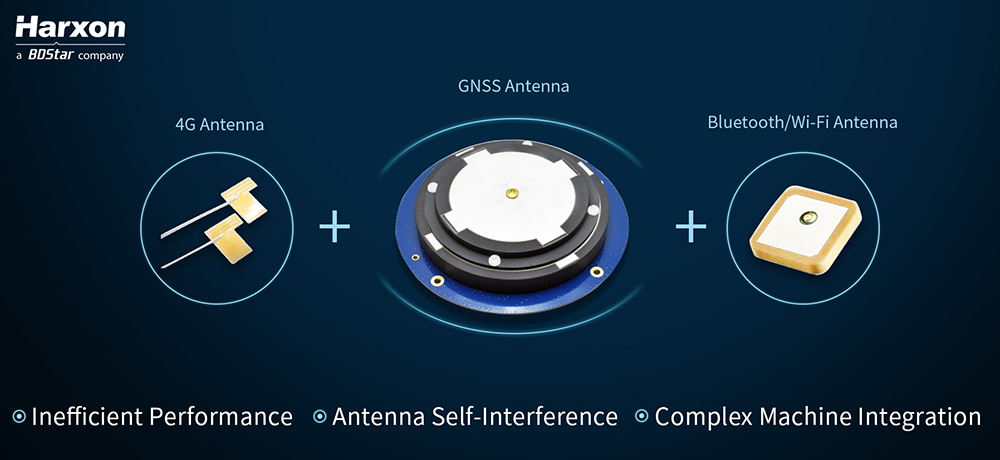
Real-time kinematic (RTK) integration usually uses separate antennas, which can lead to reduced efficiency because of electro-magnetic interference (EMI).
Image: HarxonImage: Harxon
Also, conventional antenna installation can result in unstable machine performance because of the problems of system compatibility between different antennas.
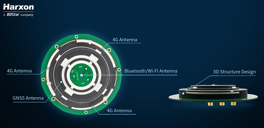
Harxon has overcome those difficulties with its integrated X-Survey antenna, a 4-in-1 OEM antenna for both navigation and communication in surveying applications.
It provides standard Wi-Fi, Bluetooth and 4G, plus multiple constellation signal reception for GNSS positioning.
The high-gain and wide-beamwidth GNSS antenna features a multi-point feeding technology, ensuring a high phase-center stability and positioning accuracy, the company said. Moreover, the array-arranged 4G antennas enables more stable signals and longer communication distance at 360-degree direction, increasing the overall machine efficiency over conventional antennas.
The X-Survey antenna provides high isolation among each antenna to prevent self-interference, improving RTK system compatibility. RF coaxial connectors are designed for plug-and-use, keeping high efficiency and lowering the impact of EMI.
The antenna low-noise amplifier features excellent out-of-band rejection performance, which can also suppress the EMI, providing reliable GNSS signals.
The unique structure design simplifies RTK integration, and minimizes the overall machine dimension. Harxon aims to bring system integrators high-efficiency performance of navigation and communication in surveying and precision agriculture applications.
4G bands can be customized according to different countries and regions, the company added.
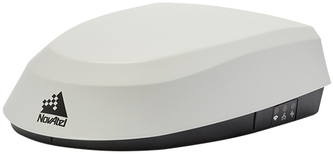
NovAtel has introduced its SMART7 family of SMART antennas for demanding applications like precision agriculture and machine control.
The SMART7 family features NovAtel’s GNSS + inertial navigation system (INS) SPAN technology; future-ready GNSS; Wi-Fi and internet protocol connectivity; superior tracking performance; and TerraStar-C PRO corrections.
It is ready to increase GNSS availability, accuracy and reliability for major precision-agriculture equipment manufacturers, the company said.
“Manufacturers that serve these demanding industries can now take advantage of the best in precise positioning technology, with added next-generation features including wireless connectivity, SPAN GNSS+INS integration and superior tracking performance, in an even more robust format,” said Gordon Ryley, Precision Agriculture Segment manager at NovAtel. “With this combination of technologies, guidance systems can continue to steer during satellite signal outages and under challenging conditions.”
The SMART7-S includes NovAtel’s tightly coupled SPAN technology, an advanced GNSS+INS integration technology NovAtel said. SPAN provides accurate attitude information that can simplify the development of vehicle guidance systems and bridge GNSS signal outages.
For easier connection to mobile devices and cellular gateways, the SMART7-W includes Wi-Fi and an integrated NTRIP client; the SMART7-I model also incorporates Ethernet. A new advanced ISOBUS-compatible CAN interface also supports NovAtel logs, commands and firmware upgrades.
All models in the SMART7 family provide exceptional positioning availability using signals from all constellations and frequencies to deliver assured positioning anywhere.
Each model includes a VEXXIS antenna, and supports TerraStar-C PRO, the newest offering from TerraStar correction services, which delivers 2.5 centimeters and convergence times of less than 18 minutes in most regions.
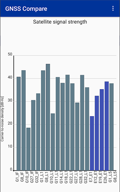
Taking advantage of the recent release of Android API 24 and the GnssMeasurement class, developers now have access to unprocessed pseudorange measurements in certain smartphones.
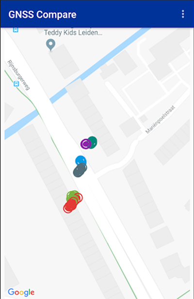
GNSS Compare is basically a tool for scientists to compare their algorithms. For those who are not GNSS experts, it can also serve as a teaching tool on the subject.
The Galileo Smartphone App Challenge was about creating a smartphone application that will allow the user to choose which satellite constellation to use for PVT estimation.
Screenshot: TFI Systems
The aim was to increase the awareness about the European Union’s Galileo satellite navigation program and also to allow users from the public to compare the performance of Galileo signals with the performance from other global satellite navigation constellations.
The app has been tested on Samsung Galaxy S8 and Xiaomi Mi 8 phones. To download, visit the store.
New research conducted at the University of Otago, New Zealand, and published in the August issue of Journal of Geodesy demonstrate that it is possible to achieve centimeter(cm)-level precise positioning on a smartphone.
The research, conducted in collaboration with Curtin University, Australia, combined signals from four different GNSS, according to Otago’s Dr. Robert Odolinski and Curtin University colleague Prof. Peter Teunissen.
“It’s all down to the mathematics we applied to make the most of the relatively low-cost technology smartphones use to receive GNSS signals, combining data from American, Chinese, Japanese and European GNSS. We believe this new capability will revolutionize applications that require cm-level positioning,” Odolinski says.
He said to understand the new technology, a look back at the historical scientific context is needed.
Precise centimeter-level positioning on a smartphone during 24 hours in Dunedin, New Zealand. Blue dots show repeatability of one epoch data in comparison to precise benchmark coordinates. The repeatability is more or less the size of a one-dollar New Zealand coin (diameter of 2.3 cm) in all three dimensions. (Image: University of Otago)
“For decades, construction, engineering, cadastral surveying and earthquake monitoring have relied on high-cost, dual-frequency GPS positioning to obtain centimeter-level location information. The challenge is that GPS signals, traveling from Earth-orbiting satellites to receivers on the ground, are disrupted along the way, and this generates errors and limiting precision.
“The traditional solution is to combine GPS signals sent at two different frequencies to improve the positions, but the antennas and receivers required have been expensive, far beyond the reach of many who would benefit from the technology,” Odolinski said.
The new approach uses only one of two frequencies but collects data from more satellites for a multi-constellation GNSS solution. The extra data and algorithms are used to improve the positions without adding cost.
Odolinski and Teunissen have shown that this approach can work in smartphones, producing competitive results compared to dual-frequency GPS solutions (see figure).
Odolinski believes that countries and industries of all sizes can benefit from using smartphones as GNSS receivers, and is confident commercial application and development will spring from this research.
“This significant reduction in costs when using smartphones can increase the number of receivers that can be deployed, which will revolutionize a range of disciplines requiring centimeter-level positioning, including precise car navigation, surveying and geophysics (deformation monitoring), to name a few.”