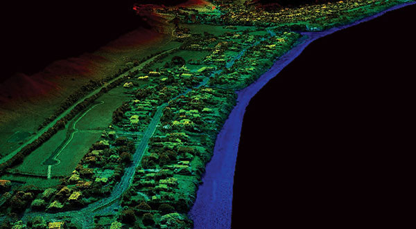
While UAVs are an exciting new technology for mapping, most respondents to our survey recognize the continued value of hands-on, in-the-field data collection.
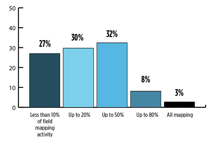
Most respondents think UAVs could be used for as much as half of data collection, but very few expect UAVs to be used for more than that. UAVs are just one mobile collection method, of course. Others include autos such as SUVs, boats and all-terrain vehicles.
What role will UAVs play in the mapping industry over the next three years? (Source: GPS World 2018 State of the GNSS Industry survey)
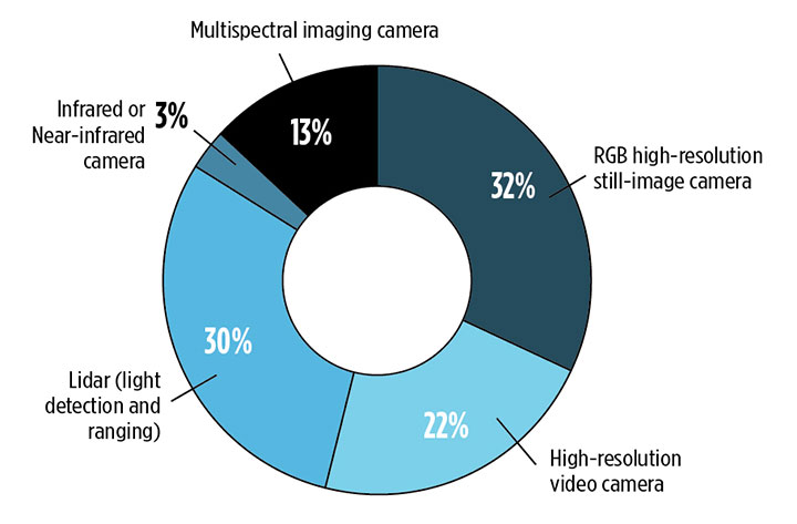
We also asked respondents how they use UAVs for data collection. RGB high-resolution still-image cameras and lidar are the most frequently used, with video cameras not far behind. Other specialty cameras collect infrared or thermal imagery, while specialty sensors collect everything from temperature to pressure and methane levels.
Whether mounted on a UAV, a vehicle, or on the ground, these technologies are used in fields as diverse as forest management, disaster response and infrastructure planning.
For instance, urban planners rely on mapping data for land value, topography and water and electricity resources. Meanwhile, forestry experts use infrared to detect areas of disease or die-off in the early stages.
Software in the Cloud. Turning to software, developments in cloud storage and open-source and subscription platforms are constantly improving geographic information systems (GIS). A wealth of GIS and GPS data is available from Google Maps, Apple Maps, OpenStreetMap and other applications. Specialty applications include Esri ArcGIS, Maptitude, Surfer and more. In the coming years, expect an increase in 3D modeling, digital elevation models (DEMs) and augmented reality.
What is the most valuable sensor to use in conjunction with GPS/GNSS aboard a UAV for mapping and data-collection purposes? What role will UAVs play in the mapping industry over the next three years? (Source: GPS World 2018 State of the GNSS Industry survey)
The automotive sector has been adopting digital mapping applications for use in self-driving cars, as well as fleet management, logistics control systems, and advanced driver assistance systems (ADAS).
Every year, more satellites are launched for mapping and GIS data collection, and they don’t all provide photo imagery. For instance, NASA’s Aqua satellite detected and mapped huge concentrations of carbon monoxide drifting east across the U.S. from western wildfires — important information for public health planning.
For more results from the 2018 State of the GNSS Industry, see this page.
Signals other than GNSS are the key to positioning for both the transportation and machine control markets. While many solutions are being developed, inertial navigation systems (INS) are emerging as the primary GNSS co-star.
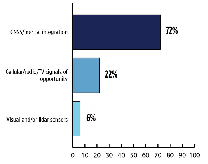
In our survey, nearly three quarters (72%) of respondents in this sector said positioning could best rely on tight integration between GNSS and INS. For comparison, inertial technology wasn’t even mentioned in the 2017 State of the GNSS Industry Report. This year for the first time, GPS World offered an Inertial Buyers Guide for our readers (see our May issue).
What is the best additional solution for positioning in GPS/GNSS-challenged environments? (Source: GPS World 2018 State of the GNSS Industry survey)
Practical autonomous navigation — the current ambition of automakers (and Google) — hits a roadblock when it comes to uninterrupted positioning. We all know GNSS reception has its limits, notably in many places that vehicles travel such as tunnels, beside tall buildings and in parking garages. Inertial positioning fills that gap, making it especially advantageous for meeting the challenges of autonomous navigation.
Inertial measurement units are generally based on multi-axis combinations of precision gyroscopes, accelerometers and magnetometers using algorithms to determine location, direction and position. Gyroscopes measure the angular velocity; accelerometers measure overall acceleration; and magnetometers provide the direction of the magnetic field.
Micro-electro-mechanical (MEMS) techniques have reduced the size, power consumption and costs of INS systems considerably, enabling their use in ever more applications, including unmanned aerial vehicles.
As a result, products that combine GNSS + INS are being introduced at an increasing rate, with more than a dozen major announcements in the past year. According to one study, the INS market is projected to grow from US$11.89 billion in 2017 to US$19.67 billion by 2023, a compound annual growth rate of 8.76%.
For more results from the 2018 State of the GNSS Industry, see this page.
Conducted online in July 2018, the GPS World State of the GNSS Industry survey compiled detailed answers to 30 key questions from 273 respondents, spread across six continents.
Prominent insights gained, and outlined in these pages: the PNT sector is booming, as opportunities outnumber obstacles; well-trained engineers are at a premium; and the Internet of Things is the newest market driver, perhaps the most powerful yet.
With 106 operational GNSS satellites flying today (or was that yesterday’s number?) satnav’s backbone is robust, variegated, supportive of growth across many industries — and poised to leverage even more prosperity. I’ve seen forecasts of as many as 400 satellites, well beyond GNSS proper and involving low-Earth orbit telcomm constellations, constantly patrolling space above us and beaming down positioning, navigation and timing (PNT) intelligence.
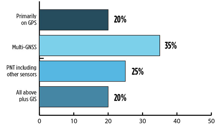
Where do you see your efforts focusing primarilly over the next decade? (Source: GPS World’s 2018 State of the Industry survey)
A draft headline for the cover of this issue — The Sky’s the Limit! — actually underestimated. Not even the sky is the limit.
Mobile. GNSS-enabled tablets and smartphones provide navigation, traffic and congestion maps to billions. These features will continue to drive demand for GNSS in all electronic equipment. As we move from the internet to the internet of things (IoT) as the dominant paradigm of advanced and developing societies, GNSS will boom louder than we have heretofore known it to do.
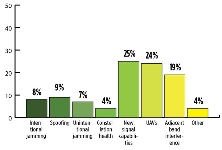
What is the industry “Issue of the Year?” (Source: GPS World’s 2018 State of the Industry survey)
Communication and location-enabled transportation services such as Lyft and Uber provide only one example of novel GNSS uses that have become the norm.
Tracking devices, whether personal, vehicular, or affixed to large assets, constitute a quiet though muscular growth market. The GPS tracking device generates high demand from industries such as information technology (IT), transportation, and telecommunication, providing real-time intelligence and advance diagnoses about products, vehicles and people, valued by consumers and businesses, enhancing security and safety — key concerns that will only grow in an increasingly vulnerable world.
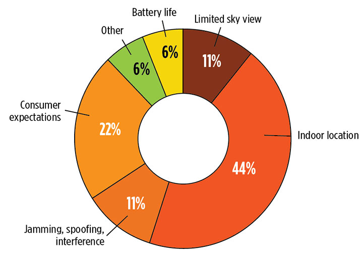
What is the key challenge for positioning and navigation in the wireless and consumer space? (Source: GPS World’s 2018 State of the Industry survey)
Volume! The GPS tracking segment alone is expected to reach $2.53 billion by 2023, nearly 12% annual growth. Other mobile segments will increase in parallel. Don’t be deceived by the low-cost of low-accuracy tracking devices. Volume! Volume! Volume! is just as powerful a mantra as Location! Location! Location!
With the wireless carriers and IoT behind it, GNSS will see growth a-plenty and virtually no downside. U.S. cell carriers are now selling access to your real-time phone location data, a key signal that economic giants put high value on the technology.
For more results from the 2018 State of the GNSS Industry, see this page.
2018 State of the GNSS Industry survey respondents who identified themselves as from the survey sector constituted 30% of the total, corresponding to the percentage of the magazine’s readership.
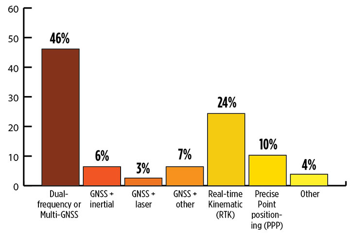
What is the most promising and practical way to gain the increased accuracy that survey and other high-precision applications continue to demand? (Source: GPS World 2018 State of the Industry survey)
Higher Accuracy. Regarding the most promising technology to get the increased accuracy that surveying continues to demand, the outright choice was “dual-frequency, dual- or multi-constellation GNSS,” with “real-time kinematic” coming in second. Surprisingly, the newest technology to be introduced to GNSS receivers, inertial correction, lagged at just over 5%.
Inertial correction devices, which contain gyroscope and accelerometer technology, are now being installed in survey-grade receivers to increase accuracy and productivity. It’s a gamechanger in GNSS data collection for surveyors, so I am surprised by the survey results. These sensors work in conjunction with the receiver to more accurately collect positional information in relation to the point being acquired. While RTK positions are normally collected at 1-20 Hz, the inertial device works in tandem to further refine a more accurate location. As this technology becomes more publicized in phones and other devices, the surveying community will begin to take notice.
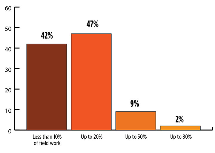
What role will drones (UAVs) play during the next three years in the survey sector? (Source: GPS World 2018 State of the Industry survey)
Drones. Concerning the role that drones (UAVs) will play in the next three years, by a slim margin — 47% to 42% — respondents state that up to 20% of their work will be completed by UAVs vs. those who feel less than 10% of their work will be done by a drone. Only1.3% answered that UAVs will take over most of their work and displace surveyors in the field for specific survey tasks.
I see UAVs becoming a standard equipment much like the EDM/total station and GNSS receivers, as it is clearly a unique tool for not just collecting visual images but as a remote sensing device. While it won’t replace workers in the field, it will allow crews to become more efficient, tech-savvy and valuable for human-only types of data collection.
Business. A whopping 85% of the survey sector found this market either “very healthy, with strong growth” (37%) or “relatively healthy, with moderate growth” (48%). This compares with total of 79% across all GNSS industry sectors. So we’re on top! That is, we are doing comparatively well amid the rest of the GNSS industry — which itself is in very good shape indeed.
Poll results reflect the positive nature of the surveying profession in relation to technology, specifically GNSS and the utilization of UAVs, in our every day work. Previously, introduction of new technology has been historically unreliable, less than user-friendly, and expensive. The trend with newer technologies, however, has been quite the opposite with shorter, easier learning curves and lower cost of entry. These factors have led more surveyors to upgrade their equipment, implementing newer technologies and thus creating more efficiency in the profession.
For more results from the 2018 State of the GNSS Industry, see this page.
TIM BURCH is a professional land surveyor and secretary, Board of Directors, National Society of Professional Surveyors.
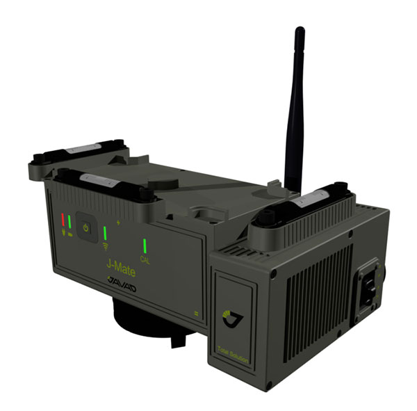
Javad GNSS has taken the power of its Triumph system and expanded to ground-based measurement technologies (versus satellite-based positioning) with the J-Mate.
The J-Mate is a new measurement module that combines conventional measurement via laser scanning and photographic imagery with the multi-constellation location accuracy of the Triumph-LS receiver.
Unlike most conventional total stations, J-Mate does not contain optics for manual use. It does, however, utilize precision horizontal and vertical encoders for angular measurement while the high-definition camera and laser module combine to locate the USB-powered target for accurate measurements, the company said.
The target rest on top of the receiver and lights up for better visibility to the camera and sensor. The lighting power comes through the USB cord connected to the receiver.
Coupled with the onboard data collector screen of the Triumph-LS, operation of the module is done visually with the LS mounted on top of the module or remotely on the J-Pod pole used for GNSS data collection.
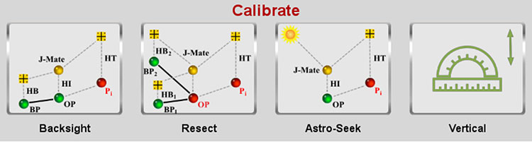
Setup of the module for survey data collection can be accomplished by several different methods: Backsight, Resect or Astro-Seek.
The Backsight method of station establishment, while following in the manner of traditional total stations, can be accomplished by several different methods utilizing the J-Mate and Triumph-LS.
The first option is to occupy a known station with pre-established horizontal and vertical values, and then proceed to orient the instrument to another known station.
The second option is using the Triumph-LS GNSS engines to establish a station coordinate value, perform the same procedure on the reference station, and use the J-Mate software to calculate backsight azimuth for orientation.
The last option is to use a combination of the known coordinates or collect GNSS-derived values for either station or backsight point and complete the station setup.
The Resect method is utilized when occupied station cannot use GNSS-observed coordinate values but can view two or more stations with known values. Once the user has measured all the visible know stations, the data-collection software provides geometric precision analysis and a coordinate solution if tolerances are acceptable.
The last method of orientation, Astro-Seek, can observe solar or lunar positions to accurately determine the location and orientation of the station. The user installs a darkening filter for solar observations and starts the Astro-Seek process; the module automatically makes necessary remaining measurements and calculations.
J-Mate screen (Image: Javad GNSS)
The J-Mate system is equipped with system parameters that allows the user to customize a variety of settings, including minimum and maximum collection distance, windowing of project area, and edge definition tolerance to fine tune scanning small objects. Also definable within the window area is the scan spacing variable, used to minimize the number of data points where needed.
According to Javad GNSS, the range of the J-Mate is rated at 100 meters (328 U.S. survey feet) using the Javad target and to most white surfaces, while the rating for darker surfaces is 50 meters (164 U.S. survey feet). Three precision vials are placed around the top for visual verification of levelness in addition to the electronic leveling mechanism, giving the user on-the-fly notification of any unstableness of the instrument.
The J-Mate isn’t exclusively a data collection system, though; this module and software is also designed to be an efficient staking application. Taking advantage of robust servos and effective targeting system, this system performs dutifully for staking applications where accuracy and precision are required.
No, this is not a drill or a major motion picture event.
During my lifetime, many natural disasters that have taken place around the globe. These unfortunate events have created mass destruction and caused many deaths by a variety of environmental elements, ranging from earthquakes and volcanic eruptions to hurricanes and snowstorms.
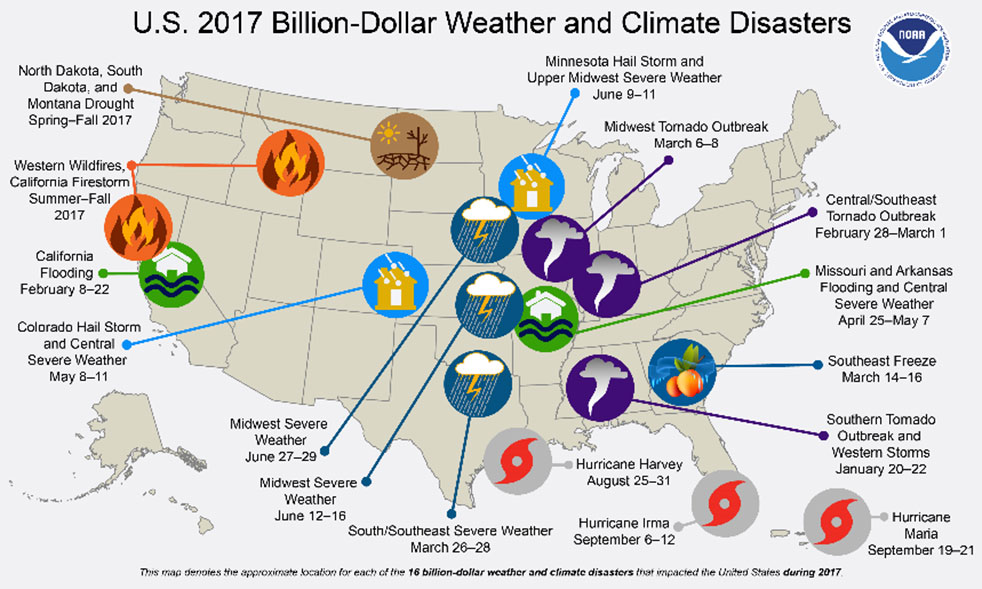
Disasters in the United States. (Image: FEMA)
Once Mother Nature decides to unleash her wrath, rarely anything stands in her way. Some types of disasters create situations worse than others, but all have a reputation of leaving a trail of death and destruction.
Search and rescue is the first and foremost priority when it comes to these disasters, with cleanup and rebuilding to soon follow.
The role of the land surveyor, however, doesn’t usually enter the discussion when it comes to these situations. It has always been considered an occupation that fills an important role in development, construction and parcel ownership, but rarely is discussed in the same terms as a fireman, policeman or doctor.
We will take a closer examination at how the surveyor uses skills developed through education, technical training and practical application of geographical data to quietly assist those in need through these difficult bouts with Mother Nature.
First, however, we will discuss various types of the deadliest natural disasters, the amount of destruction that has been caused and types of problems (besides deaths) that were left because of these tragedies.
Disasters throughout history
When describing natural disasters, the obvious ones come to mind: earthquake, hurricane/typhoon/cyclone, tornado, wildfire, flooding/monsoon, drought/famine, volcanic eruption, tsunami, sandstorm, avalanche, and snowstorm.
All of these have wreaked havoc on mankind for centuries, with more physical destruction taking place in the past few centuries.
Some of the factors leading to an increase in this devastation are gains overall population and amount of buildings and improvements in populated areas. Let’s look at how each disaster impacts the areas in which it occurs:
Flooding/Monsoon
Historically the deadliest type of natural disaster, rainfall through storms and monsoons cause flood events that have caused millions of deaths in several instances around the world. Most of the deaths caused by flooding situations are due to drowning in floodwaters that inundate areas not normally affected by normal amounts of rain.
The largest flood in recorded history took place in China during 1931, combining melting snow and ice with ongoing rain events to create a continuous flooding event that lasted most of the year. Death toll estimates range from 400,000 to almost 4 million, as many of the victims either died or moved to other regions with no trace.
Hurricane/Typhoon/Cyclone
This is another type of flooding disaster, but it combines large amounts of rain gathered from ocean storms with high winds to batter shoreline and inland areas. These storms can often stall in place, causing significant damage by both wind and rain.
Tornado
Most weather systems associated with creating tornadoes are believed to occur in the United States, but they happen all over the world. Many of the deadliest tornadoes have taken place in the Middle East, including Bangladesh, Russia and Pakistan. These storms can include torrential rain, but most of the damage caused by tornadoes is wind-related.
Earthquake
Shifting tectonic plates and earth-shaking tremors are a significant cause of damage and deaths throughout the world. Most of the highest death tolls have taken place in Asia, with the biggest loss of life occurring in Shaanxi, China, on Jan. 23, 1556, with more than 830,000 deaths.
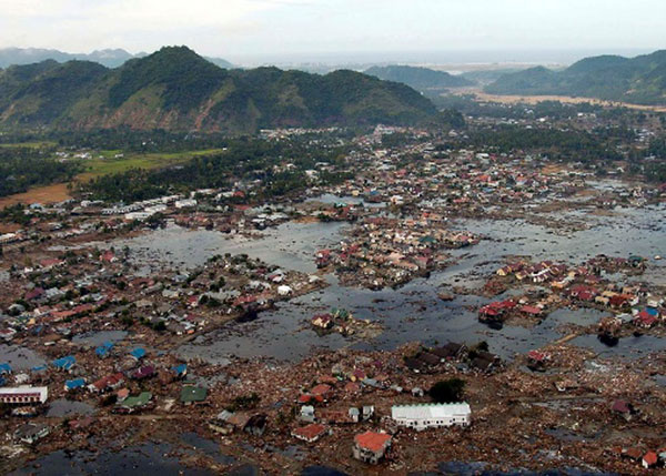
Indian Ocean (Jan. 2, 2005): A village near the coast of Sumatra lays in ruin after the Tsunami that struck South East Asia. (Photo: U.S. Navy/Photographer’s Mate 2nd Class Philip A. McDaniel)
Tsunami
Often a secondary disaster generally associated with earthquakes in coastal areas, tsunamis kill thousands by inundating shorelines with huge waves and sending vast amounts of water into low-lying areas and poorly constructed seaside villages. The largest tsunami in recent memory was on Dec. 26, 2004, in the Indian Ocean off the coast of Indonesia, with the death toll reaching 280,000 people.
Volcano
The biggest cause of earthquakes is typically molten lava expanding to shift tectonic plates, but volcanoes are formed with the lava and associated gases finding an escape in the Earth’s crust.
Once a volcano has formed, an eruption can lead to significant damage from lava flow onto adjacent land and hot ash spewed into the atmosphere. Many volcanic eruptions throughout history have buried local cities and villages, making them virtually disappear.
Wildfire
Grabbing the headlines more recently has been the proliferation of wildfires. While not causing the substantial loss-of-life associated with many other natural disasters, wildfires are responsible for scorching hundreds of thousands of acres of forest and brush areas, as well as decimating neighborhoods.
Avalanche
This disaster only takes place in locations with significant snow pack and elevation changes. After large amounts of snowfall, various factors lead to movement of large areas of snow and ice down mountainous slopes. Often these events take place near cities and villages in mountainous regions and can leave the inhabitants buried and unreachable.
Other Types of Natural Disasters
While the varieties of events listed above can create large-scale destruction, there are others that, while smaller in nature, can collectively cause great damage and loss of life. Thunderstorms, snowstorms and sandstorms are wind-related and can be devastating to the areas being affected.
Other natural disasters that often don’t get the same recognition as those listed above include drought and famine. These environmental tragedies ruin thousands of lives, and it take years to recover from the damage caused by these inflictions.
Disaster hits. Now what?
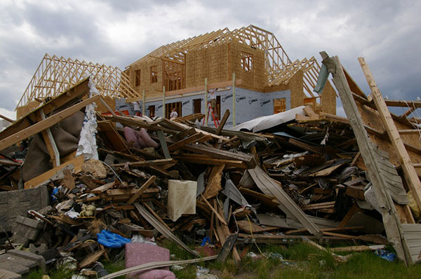
June 28, 2008: A house in Parkersburg, Iowa, is being rebuilt while debris from a deadly EF5 tornado still covers the ground. (Photo: FEMA/Richard O’Reilly)
All of these disaster types have led to a great number of fatalities and total devastation of cities and roadways. To help us understand what type of assistance the surveyor can provide, we first need to identify the conditions left by each of these events.
Most of the disasters simply wipe out whatever is in its path; from tornadoes, hurricanes, and wildfires to earthquakes, avalanches and tsunamis, the regions affected are left in shambles after the occurrence.
The initial search and rescue through the rubble takes manpower and careful identification of areas where people are known to inhabit, either as residences, places of employment or public spaces. These areas require retracement of existing mapping and atlases to accurately identify those places for timely recovery.
Once the search-and-rescue efforts have ceased and cleanup/rebuilding commences, the destroyed areas will need to be remapped based upon existing parcels and ownership rights. Reconciliation of existing parcels, subdivisions and rights-of-way will be required to properly return the injured areas to a habitable state.
The one disaster that’s a big wildcard, however, is the earthquake. The devastation is like the others and generally will need rebuilding like the others, but with one large difference; putting everything back where it belongs.
When large tremors cause significant shifts in inhabited and/or complex parcels, the ability to retrace existing parcels, subdivisions and rights-of-way to place them in their original location becomes a nightmare.
How surveyors and GNSS help before and after disasters
As expert measurers and establishers of boundaries, the surveyor provides guidance for the creation of parcels and rights-of-way. Through extensive education, training and experience, the surveyor combines field reconnaissance, legal definitions of parcels and high-level mathematics to provide direction for the creation and retracement of real property.
After experiencing a devastating event like the ones described above, the surveyor becomes a key position in rebuilding the affected area.
Prior to the invention and proliferation of GNSS technology, however, the use of state plane coordinate data was a tedious and time-consuming task (see my January 2017 article at GPS World).
Establishing coordinate values across a large region and/or utility system was not practical from a time or cost viewpoint. The arrival of GNSS technology in the 1990s changed that situation with the ability to determine coordinate values in real-time and create large databases of infrastructure and utility information. Government agencies (and surveyors) now could replicate, with acceptable accuracy and precision, locations of improvements and utilities throughout their jurisdiction.
Surveyors are now being called upon to assist with search and rescue efforts when these disasters hit to help locate and turn off existing utilities (i.e. electricity, gas, water), and to provide mapping assistance for retracing where people may be in the rubble. Because lives are at stake, timely location is essential for these services and GNSS technology use by the surveyor provides a much-needed service.
Once these disaster events being a rebuilding mode, the surveyor steps in to find the existing parcel and right-of-way lines to assist the respective owners where a deed or roadway was previously located. Most times, the surveyor can retrace existing line by locating buried monuments and recreating existing deed descriptions and/or roadway locations.
Where there becomes a problem is when the devastation is large enough to destroy all existing monuments and leave no trace of any occupied land. The surveyor must expand the search area, as far as needed, to find the closest available monuments in which to begin rebuilding the parcel descriptions.
Depending on the site conditions, GNSS equipment is used to locate the positions of the nearest monuments so the surveyor can perform retracement calculations for the disturbed area.
Once the area to be re-established to calculated, the surveyor can return to the site and place markers signifying parcels and rights-of-way for the rebuilding of roads, utilities and buildings. GNSS receivers are again utilized to increase the proficiency of the field crew by allowing the installation of the markers over a large area in a short amount of time.
How surveyors can prepare for future events
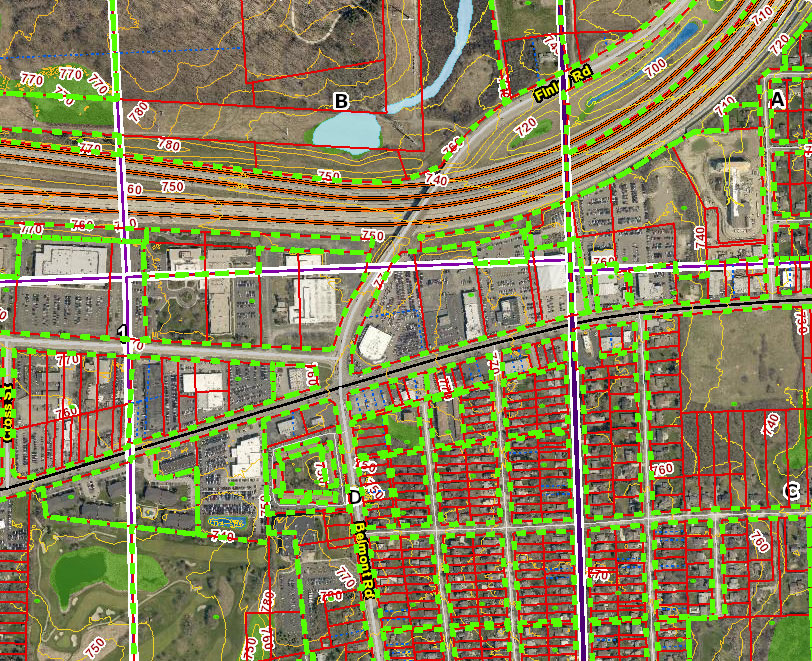
Image: DuPage County, Illinois, GIS
As previously written in my January 2017 column, GNSS technology has helped expand geographic information systems (GIS) into a database beast, containing everything from voter districts, zoning regions and floodplain maps to locations of most municipal utility maps and databases.
When these databases have included a geodetic layer of survey information overseen by the licensed land surveyor, the GIS is now more than a glorified digital Etch-A-Sketch. These entities within the database have geolocation as part of its dataset, with varying accuracy depending on the source of the data.
By having all this information available in a digital format, typically saved in a cloud-computing location, the ability to replicate these entities becomes a simple exercise. As more information becomes available, it needs to be included into the database for future mapping consideration.
All relevant data, together with a geolocation tag, becomes valuable for future retracement. This information could be used to locate possible survivors during a disaster event.
Upcoming technology to assist surveyors with disaster relief planning
Image: Esri
Many of the tools being utilized by surveyors have the capability of helping with mapping and data collection of municipal and public facilities for GIS database inclusion.
We currently use laser and lidar scanners both terrestrially and aerially to collect point-cloud data for establishing existing conditions of various sites. This point cloud, along with high-resolution photography, can be used to augment and enhance new and existing GIS databases with extensive datasets.
By having this additional information collected and available digitally, qualified experts can perform disaster simulation tests to depict various environmental events and determine what strategies will be necessary for search-and-rescue efforts.
These experts can also use this data to predict potential flood paths, conduct seismic modeling to determine building shift, and combine weather conditions with conceivable wildfire-capable areas. All these potential life-saving exercises can utilize the surveyor as a significant data-collection source.
Coming to a theater near you…
Whether one believes in climate change or just being affected by an active environmental cycle of natural disasters, the entire world is prone to have an occurrence of at least one of these events.
Since these events are not going away, remember to help your fellow man, woman or child in their time of need. It is the duty of the surveyor to provide a service that is intended to protect the public, and being there for disaster planning, prevention and recovery is part of our mission.
Think of us like the Avengers; now there’s a sequel I’d pay to see.
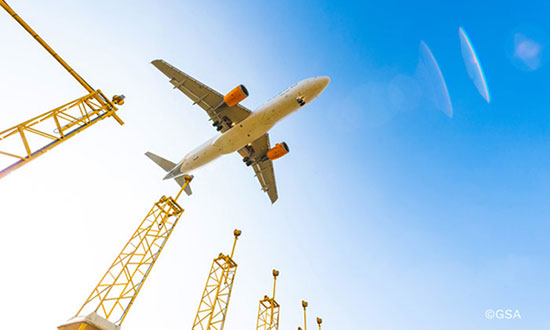
If you’ve taken a flight in Europe recently, then the chances are growing that you’ve been a pioneer EGNOS user. Satellites in orbit would have guided your airliner’s descent, rather than signals beamed from the ground. You wouldn’t have felt any difference — except for possibly a smoother ride.
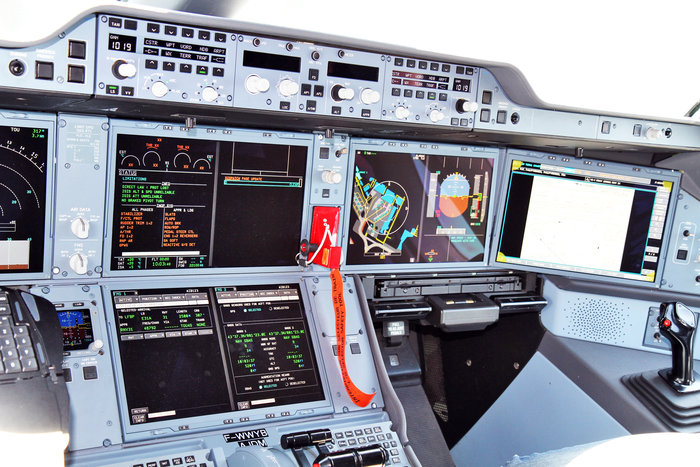
Cockpit of a new EGNOS-equipped Airbus 350 XWB, on show during the inaugural EGNOS Day at Toulouse-Blagnac Airport on May 7, 2015. (Photo: ESA)
More than 180 European airports have now been certified to make use of the ESA-designed European Geostationary Navigation Overlay Service — EGNOS — for approaches to given runways. This includes approaches at major hubs such as Paris Charles de Gaulle, Frankfurt and Amsterdam Schiphol. Thanks to EGNOS, safe landings would still be possible even if an airport were shut down entirely.
Sharpening the precision of GPS satnav signals over most European territory, EGNOS was designed to make satnav reliable enough for safety-critical aviation employment, but has found a wide range of other uses, from agriculture to road, rail and maritime transport.
An EGNOS app is available from the Apple and Google Play stores, offering easy access to all EGNOS-related information, including the different EGNOS services, official documentation, historical and current performance data, support material and contact with the 24/7 EGNOS helpdesk.
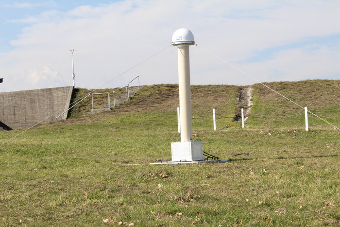
An EGNOS V3 Ranging and Integrity Monitoring Station (RAIMS) being tested at the Santiago de Compostella site in Spain, designed and manufactured by Thales Alenia Space in Italy. (Photo: ESA)
EGNOS is based on a network of monitoring stations across Europe that perform independent measurements of GPS signals, so that corrections can be calculated to boost satnav positioning performance. These results are passed to users immediately via a trio of geostationary satellites.
The service is allowed just a one in 10 million chance of error. If this tolerance is exceeded, EGNOS users are informed within six seconds. The result is that EGNOS-augmented signals meet the extremely high performance standards set out by the International Civil Aviation Authority, adapted for Europe by Eurocontrol, the European Organisation for the Safety of Air Navigation.
EGNOS operations are the responsibility of the European Global Navigation Satellite System Agency (GSA) of the European Commission and run by the ESSP, European Satellite Services Provider.
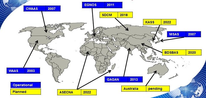
EGNOS is the European equivalent of the U.S. Wide Area Augmentation System (WAAS), which was the world’s first satellite-based augmentation system. The U.S. and European systems have been carefully designed to work together seamlessly.
Additional equivalent regional systems, fully interoperable with the existing ones are either in operation (Japan, India, Canada) or in definition or development (Russia, China, South Korea, West Africa and Australia).
Satellite-based augmentation systems worldwide. (Image: ESA)
Through the LPV-200 procedure, short for “localizer performance with vertical guidance 200 feet,” signals from space guide pilots through any weather down to within just 60 meters (200 feet) of the runway, at which point they make visual contact with the ground for a final go/no go landing decision.
EGNOS offers all-weather access to all certified runway approaches — each side of a runway requiring its own, separate, certification — without the need for expensive ground Instrument Landing System infrastructure. Satellite-based landing approaches can also be tailored to be smoother and more fuel-efficient.
Smaller airports unable to afford ground instrumentation draw the greatest benefit. Employing EGNOS means they get to operate in all weather conditions.
ESA retains the lead role in the future development of EGNOS, working with Thales Alenia Space and Airbus Defence and Space and their subcontractors to design, develop, deploy, and validate and test the new design elements.
While the current system is solely reliant on GPS, the next-generation EGNOS V3 will combine the use of GPS with Europe’s own Galileo satnav system to boost EGNOS accuracy and reliability still further. It is planned to enter service around 2025.
Hemisphere GNSS has closed its definitive agreement to purchase all of the assets of the Outback Guidance business from AgJunction Inc., along with a new technology licensing agreement.
The acquisition aligns well with Hemisphere’s continued push into the global agriculture market, the company said. In addition to the included IP (intellectual property) licenses for business into the dealer channel, a second license was finalized to allow agriculture steering solutions sales into OEM (original equipment manufacturer), VAR (value-added reseller), and all other segments of the agriculture supply chain.
Hemisphere has assumed ownership of the Outback assets, including a global sales channel, infrastructure and trademarks. Additionally, licenses to IP and related technology have been executed. Also included are two product development, sales and support facilities, including personnel, located in Hiawatha, Kansas, and Winnipeg, Manitoba, Canada.
“Outback’s highly knowledgeable personnel and dealer network will provide us with a key piece of the agriculture supply chain that perfectly complements Hemisphere’s current global agriculture strategy,” said Farlin Halsey, president and chief executive officer of Hemisphere GNSS.
Jeffrey Farrar will lead the Outback business as general manager. Before joining Hemisphere, Farrar was vice president of sales for AgJunction and served in a capacity of director and senior management-level positions for both sales and marketing for AgJunction and Hemisphere GPS. “Jeffrey’s previous leadership and history with the Outback business makes him the ideal person to direct the future growth of this business,” Halsey said.
“Outback has always been a household name in the agriculture space associated with simplicity, performance, and value, and we intend to keep it that way,” Farrar said. “I look forward to ensuring that the Outback business thrives and that the solution and technology offerings are maintained and supported, as we look to refresh and update product lineups. We are committed to helping and supporting our dealer network, farmers, and growers alike to ensure they continue feeding the world.”
The addition of Outback represents Hemisphere’s continued effort to make significant investments to expand its presence in the global agricultural market. Hemisphere has seen successful revenues and wide-reaching positive feedback in recent years with its OEM-focused agriculture products. Hemisphere seeks to further integrate its high-precision GNSS positioning technology via systems and services offered by the Outback dealer network.
The Outback channels of communication including customer support, sales and website, will remain as they currently operate. The Outback dealer network will not see any interruption during this transition period.
Trimble has launched a new model of its premium GNSS receiver, the Trimble R10 Model 2 GNSS System. Designed to help surveyors in a wide range of industries work more effectively and productively, the Model 2 enables reliable, fast and accurate collection of survey data in the field, the company said.
Enhancements in Model 2:
The latest and most advanced custom Trimble survey GNSS ASIC with 672 GNSS channels for unrivaled GNSS constellation tracking, including GPS, GLONASS, BeiDou, Galileo, QZSS and IRNSS as well as the full range of SBAS. The Trimble R10 Model 2 tracks and processes all of today’s available GNSS signals and is designed to support planned GNSS signals and systems that may be launched in the future.
Improved reliability against sources of interference and spoofed signals.
Improved power management to increase battery life and operating time in the field on average by 33 percent.
Increased internal memory (6 GB) to store more than 10 years of raw observations.
Support for Android and iOS platforms to allow organizations with Bring Your Own Device (BYOD) environments to benefit from a premium survey GNSS receiver by using the mobile devices their field crews already have in their pockets.
The new features build on the Trimble R10’s core technologies, which include the Trimble HD-GNSS processing engine that enables points to be quickly measured with confidence, Trimble SurePoint technology for precise positioning capture and full tilt compensation, Trimble xFill technology for centimeter-level positioning during GNSS outages, and support for Trimble CenterPoint RTX corrections for RTK level precision worldwide.
Advanced GNSS rover system
The Trimble R10 Model 2 supports the recently released Trimble TSC7 controller and Trimble Access 2018 field software. The Trimble R10, in combination with the TSC7’s large 7-inch screen and faster processing power plus Trimble Access 2018’s new user interface and graphics capabilities, gives surveyors a superior, comprehensive solution for collecting and computing data in the field.
“These improvements ensure the Trimble R10 remains one of the most current and relevant GNSS survey solutions on the market today,” said Olivier Casabianca, director of global marketing for Trimble Geospatial. “By providing a powerful rover system such as the R10 Model 2, TSC7 controller and Access 2018 field software, Trimble continues its legacy of unmatched GNSS expertise and knowledge to advance the capabilities of surveyors around the world.”
A team from Aerospace Corporation won a U.S. Army challenge designed to identify artificial intelligence and machine learning tools that could improve the speed and accuracy of electronic warfare operations.
The Army Signal Classification Challenge invited participants to prove they had the best artificial intelligence and machine learning algorithms for performing “blind” radio frequency signal classification quickly and accurately.
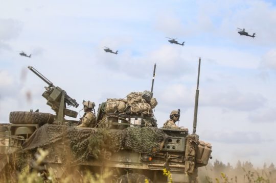
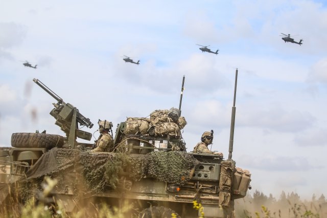
An Interim Armored Vehicle “Stryker” and AH-64 Apache helicopters with Battle Group Poland move to secure an area during a lethality demonstration as part of Saber Strike 18 in June 2018. (Photo: U.S. Army/Spc. Hubert D. Delany III, 22nd Mobile Public Affairs Detachment)
The goal was to find solutions that could reduce the cognitive burden placed on electronic warfare soldiers by identifying signals of interest in the electromagnetic spectrum.
The Army , Rapid Capabilities Office (RCO) launched the challenge because the classic signal detection process is no longer efficient in understanding the vast amount of information presented to electronic warfare soldiers on the battlefield by an ever-increasing number of satellite signals, radars, phones and other devices.
More than 150 teams from across universities, laboratories, industry and government participated. The first-place award of $100,000 went to Platypus Aerospace from Aerospace Corporation, a federally funded research and development center.
Second place, with an award of $30,000, went to TeamAU, made up of a team of individual Australian data scientists. Third place and $20,000 went to THUNDERINGPANDA of Motorola Solutions.
“The amount of interest and quality of performance was remarkable, including from nontraditional organizations,” said Rob Monto, Emerging Technologies director for the RCO. “In doing this as a challenge, instead of a traditional Request for Information, we were really modeling what industry does to get at a problem quickly. It was performance-based, open to anyone and implemented without a lot of cost or burden placed on those entering. And now, in a matter of less than four months, we know mathematically who has the best performance for this initial step of applying AI and machine learning to signal classification.”
The challenge, which opened on April 30 and closed on Aug. 13, gave participants 90 days to develop their models and work with training datasets provided by the RCO. That was followed by two test datasets of varying complexity that were the basis for judging submissions.
Participants’ overall challenge score was based on a combined weighted score for both test datasets. Participants were also able to see how they were performing in relation to others in real time, via the participant leaderboard.
“This challenge targeted the upfront data collection, which is traditionally very labor intensive and time consuming,” Monto said. “Now we have a very accurate, very rapid algorithm for a specific problem set. With this research done on the front end, we can move forward with trying to build and integrate it into a real solution for the Army.”
A second phase of the competition is planned and details will be announced later this year.
“We’re thrilled to see our team win this competition through their novel application of artificial intelligence to secure the use and protection of the radio frequency spectrum,” said Steve Isakowitz, Aerospace president and CEO. “Their accomplishment is another great example of how Aerospace is employing cutting-edge technology to advance next-generation capabilities for the warfighter while solving one of our customer’s most difficult challenges.”
Aerospace engineers, named “Team Platypus,” win the Army AI Challenge. From left: Eugene Grayver, Alexander Utter, Andres Vila, Donna Branchevsky, Esteban Valles, Darren Semmen, Sebastian Olsen, Kyle Logue (not pictured). (Photo: Aerospace Corp.)
The group, known as “Team Playtpus,” consists of eight Aerospace communications systems and artificial intelligence engineers: Andres Vila, Kyle Logue, Esteban Valles, Donna Branchevsky, Sebastian Olsen, Alexander Utter, Darren Semmen and Eugene Grayver.
Out of more than 150 overall participants, including 49 teams that actively competed in the challenge, the Aerospace team won by correctly detecting and classifying the greatest number of radio frequency signals using a combination of signal processing and AI technologies.
“In its challenge, the Army RCO released a training set with synthesized data that the teams used to build their algorithms,” said Andres Vila, Aerospace team lead. “Our goal was to combine the team’s deep history and expertise in advanced satellite communications with our practical knowledge of the latest in machine learning and deep neural networks to provide a best-in-class solution.”
Vila added, “This win means that we have built a team that can excel in this new and exciting field of machine learning and specifically deep learning solutions for communication problems.”
The Korea Research Institute of Ships and Oceans Engineering (KRISO) has awarded UrsaNav a contract to supply an eLoran Transmitter Test Bed System in the Republic of Korea.
UrsaNav, the exclusive, worldwide distributor of Nautel’s NL Series transmitters, will provide eLoran transmitter technology, as well as timing and control equipment.
A meeting to kick off the eLoran work. (Photo: UrsaNav)
The contract, awarded through UrsaNav’s agent Dong Kang M-Tech, represents the first phase in a broader program to upgrade Korea’s Loran-C stations to be the foundation of a sovereign Enhanced Loran (eLoran) positioning, navigation and timing (PNT) service.
The Republic of Korea recognizes the challenges associated with relying solely on space-based signals, the relative ease with which those signals can be jammed or spoofed, and the necessity to provide trusted time and position to its citizens and critical national infrastructure, UrsaNav said in a press release.
The press release also included the following description of the importance of eLoran.
Accurate time and position are necessary components upon which many critical infrastructure sectors rely, including maritime, aviation, electrical distribution, telecommunications, finance/banking, and digital broadcast. A complementary PNT (CPNT) service provides continuity of operations through alternative and diverse timing and positioning information. CPNT is a vital element in ensuring national security and assuring Trusted Time and Trusted Position.
eLoran is the latest in the longstanding series of low-frequency (LF), LOng-RAnge Navigation (LORAN) systems. It meets the accuracy, availability, integrity, and continuity performance requirements for maritime harbor entrance and approach maneuvers, aviation En Route and Non-Precision Approaches, land-mobile vehicle navigation, and location-based services. It provides bearing (azimuth) information, even when the user is not moving, and has built-in integrity. Users within the coverage area can simultaneously synchronize their timing to absolute (not relative) UTC. Of equal importance is that the eLoran signal includes one or more Loran Data Channels that are available to provide one-way, low data rate, “Short Message Service” information.
eLoran is completely independent of GPS/GNSS, operates in the internationally protected 90 to 110 kHz spectrum, is built on internationally standardized Loran-C, and provides a high-power PNT service for use by all timing and navigation users. SAE International expects to release eLoran standards this year. The RTCM also has maritime-related eLoran standards underway.
eLoran is a key vertex of a Resilience Triad that would typically include space-based, terrestrial, and at least one other PNT source. It is a very-wide area (i.e., country-wide or “continental”) source of PNT that continues providing a resilient solution even when GNSS may be unavailable or untrustworthy. eLoran delivers information comparable to that of GNSS, but with completely different phenomenology. It is a very high-power, LF, pulsed transmission, whereas GNSS are low-power, UHF, multiple modulation scheme transmissions. eLoran is literally at the other end of the spectrum from GNSS, and has completely dissimilar failure modes. That is, an issue that disrupts GNSS is unlikely to disrupt eLoran. The unique characteristics of eLoran enable its use in environments where GNSS does not work very well, or at all (e.g., indoors, underwater, underground, and in mountain or urban canyons).
eLoran is exceptionally difficult to spoof or jam, and it is nearly impossible to do so at a distance. Just as equipment required to spoof and jam GNSS must mimic relatively low powered GNSS transmissions, spoofing and jamming eLoran requires very high powered transmissions. Equipment needs alone to disrupt eLoran over a significant area would be almost prohibitive for any actor other than a nation state engaged in open conflict. This is the reason that an independent assessment by researchers at Stanford University described eLoran as “for all practical purposes, unjammable” across any significant area. A MITRE paper concluded: “The analysis shows a very low probability of successfully producing operationally significant interference.”
 Most respondents think UAVs could be used for as much as half of data collection, but very few expect UAVs to be used for more than that. UAVs are just one mobile collection method, of course. Others include autos such as SUVs, boats and all-terrain vehicles.