Category: Applications

  • FreeFlight SBAS/GNSS receiver chosen for USAF helicopter fleet

    FreeFlight SBAS/GNSS receiver chosen for USAF helicopter fleet

    A FreeFlight Systems SBAS/GNSS receiver has been selected to provide ADS-B position source information as a part of an upcoming ADS-B modification and compliance program for the United States Air Force HH-60G helicopter fleet.

    Strategic Enterprise Solutions Corp. (SESC) of Warner Robins, Georgia, was awarded the modification program, which includes installation of the 1203C SBAS/GNSS receiver and the AN/APX-119 Mode S Extended Squitter transponder with Mode 5 capability to provide a complete ADS-B Out solution for more than 100 helicopters.

    An HH-60 Pave Hawk helicopter lands in Afghanistan; a UH-60 Blackhawk is in the background. (Photo: (U.S. Air Force photo/Senior Airman Brian Ferguson)
    An HH-60 Pave Hawk helicopter lands in Afghanistan; a UH-60 Blackhawk is in the background. (Photo: U.S. Air Force photo/Senior Airman Brian Ferguson)

    The FreeFlight Systems 1203C SBAS/GNSS receiver is a certified, high-integrity position source in a compact, lightweight package that was designed to be modular and able to be integrated with various other avionics.

    The 1203C pairs seamlessly with certified Mode S Extended Squitter transponders for a fully rule-compliant ADS-B Out system, FreeFlight said.

    More than a war hawk. The primary mission of the HH-60G Pave Hawk helicopter is to conduct day or night personnel recovery operations into hostile environments to recover isolated personnel during war.

    The HH-60G is also tasked to perform military operations other than war, including civil search and rescue, medical evacuation, disaster response, humanitarian assistance, security cooperation/aviation advisory, NASA space flight support, and rescue command and control.

    The 1203C in service. With several hundred 1203Cs in service across airline transport, military, business aviation and rotorcraft platforms, these receivers are known for their high performance, ease of installation, operational reliability and longevity, FreeFlight said.
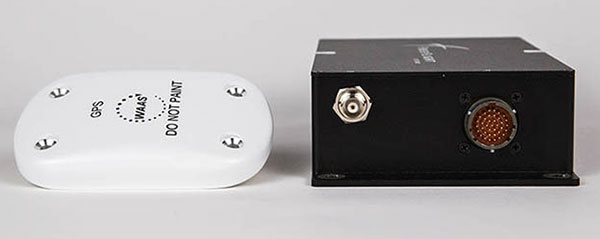
    The 1203C SBAS/GNSS receiver and antenna (Photo: FreeFlight Systems)
    The 1203C SBAS/GNSS receiver and antenna (Photo: FreeFlight Systems)

    The 1203C can also serve as the approved position source for select manufacturers of TAWS/FMS, RNP and other NextGen applications, and allows customers to take advantage of the operational and safety benefits provided by the NextGen airspace transformation without the need for extensive and costly avionics upgrades.

    With the ADS-B mandate now only 17 months away, aircraft operators need to prioritize ADS-B installations.

    Significant portions of today’s airline, business, and military aircraft fleet will remain in service long after 2020, and in many cases an STC’d retrofit solution comprising of a transponder upgrade and the addition of a dedicated SBAS/GNSS receiver like the 1203C is the simplest and most cost-effective way to achieve mandate compliance, FreeFlight said.

  • NXP partners with Columbus Smart City Challenge

    NXP Semiconductors N.V. has announced the next phase in its Smart City collaboration with Columbus, Ohio, the winner of the 2016 U.S. Department of Transportation’s $40 million Smart City Challenge.

    NXP will contribute key technologies for smart and safe mobility to the Smart Columbus Experience Center.

    Smart Center. On June 30, the City of Columbus celebrated the opening of its Smart Columbus Experience Center. The center allows visitors to see how new mobility options, such as connected, autonomous, shared and electric vehicles, will help make Columbus a more connected community.

    Hands-on educational experiences and technology demonstrations aim to show visitors how technology and innovation in transportation can grow the local economy and create ladders of opportunity for central Ohio residents.

    Visitors to the Smart Columbus Experience Center will learn how Vehicle to Everything (V2X) Technology allows cars to communicate with each other as well as with intelligent traffic infrastructure to keep mobility safe and efficient. (Image: NXP USA)
    Visitors to the Smart Columbus Experience Center will learn how Vehicle to Everything (V2X) Technology allows cars to communicate with each other as well as with intelligent traffic infrastructure to keep mobility safe and efficient. (Image: NXP USA)

    Cohda Wireless. As part of the Smart Columbus Experience Center initiative, NXP and Cohda Wireless will deploy a connected vehicle environment through the center’s electric vehicle test drive area so drivers can experience this future technology in person.

    NXP has also donated an electric motorcycle with an accompanying drone that alerts the driver to dangers or delays ahead.

    Key smart city technologies

    As part of its commitment to Columbus, NXP will continue to contribute key mobility technologies to the Smart Columbus Experience Center, including:

    • NXP’s RoadLINK V2X technology allows cars to communicate with each other as well as with intelligent traffic infrastructures. The IEEE802.11p Dedicated Short Range Communications (DSRC) standard allows cars to securely connect to each other as well as to infrastructure. DSRC technology is the only ADAS sensor that can look around the corner and offers lowest latency in the communication.
    • Smart Card IC technology that enhances transportation for all citizens by supporting secure and convenient public transportation ticketing and payment systems, including contactless transit fare solutions.
    • Highly secure NXP Radio Frequency Identification (RFID) solutions designed to promote public safety and convenience. Smart City applications for this NXP technology include vehicle window stickers that enhance driver convenience and reduce municipal costs by eliminating the need for stop-and-pay stations in public parking spaces.
    NXP eBike and Drone demo at the new Smart Columbus Experience Center shows how drones could send real-time video of a traffic incident to a city emergency vehicle. (Image: NXP USA)
    NXP eBike and Drone demo at the new Smart Columbus Experience Center shows how drones could send real-time video of a traffic incident to a city emergency vehicle. (Image: NXP USA)

    Concept of Operations released

    Smart Columbus, the smart city initiative from the City of Columbus, in July released the Concept of Operations for its Connected Vehicle Environment (CVE) pilot.

    The Concept of Operations outlines in detail how the CVE pilot will be implemented over the next two years. The pilot will involve:

    • 113 road side units (RSUs) that will be installed at intersections with stoplights
    • up to 1,800 on-board units (OBUs) that will be installed on participating private, emergency transit and freight vehicles, and
    • 12 vehicle-to-vehicle or vehicle-to-infrastructure applications that will be deployed, according to the document.

    Goals of the CVE pilot include improvements of:

    • vehicle operator safety
    • intersection safety
    • school zone safety
    • reliability of transit vehicle schedule adherence
    • emergency vehicle response times
    • traffic management capabilities.

    Smart city demonstrations. Visitors to the Smart Columbus Experience Center can try out electric automobiles. A fleet of six electric vehicles will be on display and is available for test drives through a connected vehicle environment provided by NXP and Cohda Wireless.

    Vehicles on display or available for test drives include:

    • a BMW i3 provided by BMW
    • a Chevrolet Bolt provided by Dave Gill Chevrolet
    • a Honda Clarity provided by Honda
    • a Mercedes-Benz GLE 55e provided by Daimler
    • a Nissan LEAF provided by Nissan North America
    • a Toyota Prius Prime provided by Toyota.

    An electric motorcycle provided by NXP and a Ford Ojo electric scooter are also on display.

  • QZSS satellites benefit Western Australia industries, study shows

    Curtin University researchers found the launch of new Japanese satellites has boosted satellite positioning capabilities in Western Australia (WA), offering huge potential benefits across numerous industries including mining, surveying and navigation.

    New research, published in the journal GPS Solutions, found signals from the recently launched Japanese QZSS satellites provide centimeter-level positioning accuracy, and thus significantly enhanced positioning capabilities in WA, thereby improving accuracy, reliability and availability.

    Lead researcher Professor Peter Teunissen, of Curtin’s School of Earth and Planetary Sciences, said these results will improve further when the QZSS signals are combined with those from other satellite systems such as the Indian NavIC system.

    Teunissen said the analyses done by Curtin’s GNSS Research Centre demonstrated the highly accurate centimeter-level positioning capabilities that can now be achieved.

    “Such improved positioning, accuracy and reliability would offer great benefits when applied in fields such as open-pit mining, surveying, hydrography, automated navigation, structural health monitoring, and subsidence and tectonic deformation monitoring used in the geospatial industry,” Teunissen said. “The benefits are not only restricted to positioning, but cover the whole range of satellite signal applications, including atmospheric sensing (ionosphere and troposphere) as used for climate change and space weather studies, and numerical weather prediction.”

    Teunissen said WA was in the fortunate and unique geographical position of being located beneath the flight paths of both the Japanese QZSS and the Indian NavIC regional satellite systems.

    “Using both satellite systems, QZSS and NavIC, offers huge benefits to users in Australia – and this is an opportunity to work on future developments with such technologies,” Professor Teunissen said.

    “The United States of America, for example, can’t use these signals the way we can in Australia, so this places us in a position of great advantage when it comes to the understanding, modelling and analyses of these satellite signals and their many practical applications.

    “The tracking and analyses were done using Javad GNSS receivers and Curtin’s theory of integer ambiguity resolution, which enables millimeter-level satellite ranging, and was achieved with the use of only the four currently available QZSS satellites.”

    The results bode well for the future, with the Japanese system being further developed from the current four-satellite system into a mature seven-satellite system that is expected to be operational by 2020.

    The report, “Australia-First High-Precision Positioning Results with New Japanese QZSS Regional Satellite System, is available online.

  • Ford details drone-based vehicle sensor backup

    Ford details drone-based vehicle sensor backup

    Ford has applied for a patent that would send a drone to dock with an autonomous vehicle and act as a surrogate sensor if one of the car’s sensors failed. The UAV then uses its own sensors to guide the car to a repair facility.

    A UAV docks with a car. (Diagram: Ford’s patent application)
    A UAV docks with a car. (Diagram: Ford’s patent application)

    The filing from Ford Global Technologies, a subsidiary that manages and commercializes patents and copyrights, outlines the process.

    Once the vehicle registers a fault in one of its sensors, it uses a vehicle-to-vehicle (V2V) network to summon the drone, which flies to the vehicle, receives authorization, and then lands atop it. The UAV then serves as a replacement sensor while directing the vehicle to a nearby repair center to fix the car’s sensor.

    Ford developed the technology to aid autonomous vehicles that have lost a critical navigation sensor; autonomous cars use GNSS, short- and long-range radar, lidar, cameras and ultrasound.

  • OEM module makes light work of mapping

    OEM module makes light work of mapping

    The BYes “GetYourSpace” service collects and analyzes lighting in urban environments using a GIS-based approach and the Trimble MB-TWO GNSS module.

    One of the most visible services provided by cities and municipalities is the illumination of streets and public spaces. To optimize the use of public funds, cities need timely, comprehensive information on how their lighting systems are working. Operators use the data to monitor system performance and plan maintenance, repairs and upgrades.

    Gathering data on street lighting is often performed manually. Technicians carrying photometers and clipboards visit individual light poles to collect information on the lighting output. The work, which must be performed at night, is slow and labor-intensive and can pose safety issues for the field technicians.

    GetYourSpace debuts

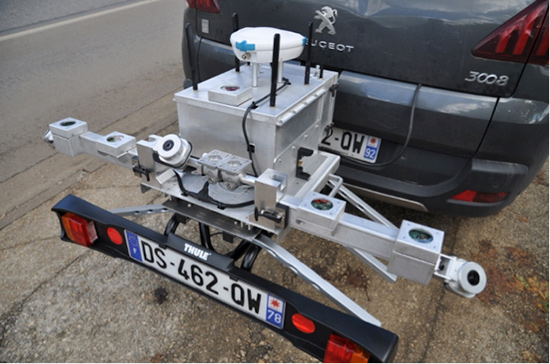
    GetYourSpace platform: The white G-Nav smart antenna contains the Trimble MB-TWO GNSS module. (Photo: Trimble)
    GetYourSpace platform: The white G-Nav smart antenna contains the Trimble MB-TWO GNSS module. (Photo: Trimble)

    The French company Bouygues Energies & Services (BYes) provides solutions that help cities operate efficiently. The company recognized the need for a mobile, automated system to collect lighting data and produce results accessible by a variety of users.

    The opportunity evolved into the BYes “GetYourSpace” service, which collects and analyzes lighting and other facets of urban environments. It uses a GIS-based approach to provide mapping and visualization functions.

    BYes set out to develop a compact platform that could detect and measure sources and characteristics of light. To present information using GIS, the GetYourSpace platform needed to include reliable geolocation. BYes called on Cadden, a French developer of location systems for marine and industrial applications, to provide the positioning component for the GetYourSpace platform.

    Reliable geolocation

    MB-Two module by Trimble.
    MB-Two module by Trimble.

    For the GetYourSpace collaboration, Cadden proposed a version of its G-Nav smart antenna, a product from Cadden’s GEOD brand. The G-Nav is built around a Trimble MB-TWO compact OEM GNSS module, an advanced GNSS receiver in a compact form designed for easy integration. The MB-TWO provides a range of GNSS configuration options, which allowed Cadden to produce a positioning system tailored to the BYes requirements.

    The communications ability of the MB-TWO enabled Cadden to streamline the development process. The module provides multiple input/output options and can be configured and controlled using a web interface as well as a simple ASCII command set. Cadden leveraged the module’s small size and low power requirements to embed it into a compact, robust GNSS unit that combines power and data into a single connection.

    High-speed data collection

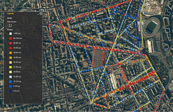
    Heat map of lighting data collected by GetYourSpace. Accurate geolocation is essential to producing easy-to-use results. (Image: BYes, Trimble)
    Heat map of lighting data collected by GetYourSpace. Accurate geolocation is essential to producing easy-to-use results. (Image: BYes, Trimble)

    Cadden’s implementation of Trimble GNSS provided key enabling technology for GetYourSpace. With an area of 1 square meter, the mobile platform includes the GNSS, light and environmental sensors, system controller and data logging.

    The MB-TWO rapid update rate (up to 50 Hz) enables the GetYourSpace platform to capture accurate information even while moving at high speed. The low-power, lightweight platform can be mounted on a small car or towed behind a bicycle and requires minimal interaction with the operator or driver.

  • Cluster Averaging with ease for the surveyor

    Cluster Averaging with ease for the surveyor

    Javad GNSS, makers of the Triumph-LS Rover receiver and the Triumph-1 and -2 base units, is offering a software procedure called Cluster Averaging, which takes advantage of its six different RTK engines and the J-Field receiver firmware.

    While a typical survey point collected by RTK methods requires multiple occupations to verify the integrity of the location and elevation, Javad GNSS’ J-Field program significantly reduces survey by collecting multiple sets of survey data through each RTK engine, the company said. During the data acquisition process, the receiver automatically forces a loss of satellite lock and restart to ensure multiple sets of independent data are collected for redundancy and quality assurance.

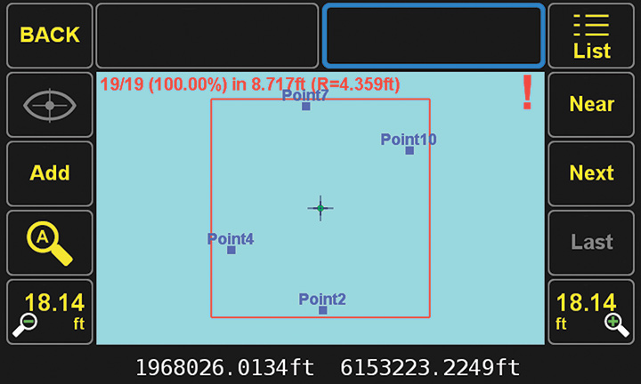
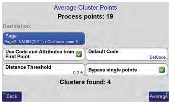
    Four groups of surveyed points. (Image: Javad GNSS)
    Four groups of surveyed points. (Image: Javad GNSS)

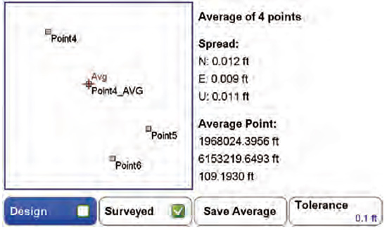
    As the surveyor returns for another set of redundant data, Cluster Averaging will recognize the previous surveyed points to provide error analysis using their chosen parameters for quality assurance. The surveyor may allow the J-Field software to average all of the data points or pick and choose those needing specific verifications. Also, the surveyor can specific different precisions for varying types of data collection (for example, control points vs. topographic data).

    (Image: Javad GNSS)
    (Image: Javad GNSS)

    Point numbering and data attributes are also automated during the cluster averaging processes. Once the operator has designated both number and field code, this information is reused each time to eliminate potential conflicts.

    Reports from the J-Field program documenting the locations with multiple occupations are easy to generate and informative, Javad GNSS said. By reviewing the results of the clusters, data integrity can be decided at the time of the survey and save time by later office verification. The surveyor can confidently complete the survey task knowing proof of accurate data for the project is at his/her fingertips.

    (Image: Javad GNSS)
    (Image: Javad GNSS)

    Cluster averaging within the J-Field program simplifies the redundant task of point verification, with a user-friendly interface and report, the company added.

  • How geospatial data can improve US elections

    Image: iStock.com/YinYang
    A voter enters a polling place. (Image: iStock.com/YinYang)

    With the mid-term elections coming ever nearer, states are turning to geographic information systems (GIS) to help manage them.

    Digital geographic representation of precinct boundaries within a GIS allow for transparency and ease of use for voters, candidates and electoral management, according to the National States Geographic Information Council (NSGIC).

    GIS also enables the optimal siting of polling places for both voter access and the cost efficiency of operating polls.

    Finally, GIS provides a platform for automated quality-control processes that ensure accurate voter precinct assignments.

    “An electoral system with integrity — enhanced by accurate, authoritative geographic data and presented clearly and transparently — has never been more important,” said NSGIC President Andy Rowan.

    Why GIS is an improvement over address files

    NSGIC’s Geo-Enabled Elections project brings together geographic information systems (GIS) leaders in state government, local elections officials and state elections offices, national GIS and elections organizations, and federal partners to identify opportunities to integrate GIS into elections systems across the country.

    The overall goal is to strengthen elections management and citizen engagement. The project aims to provide the impetus for replacing non-spatial “address file” tables with the visual and analytical advantages of election precinct and voter data in a natively GIS format.

    Geo-enabled elections overcome the four fundamental challenges with the existing address list approach to precinct management, according to Rowan.

    In the address list approach, Rowan said,

    • No actual boundaries are stored explicitly in the systems,
    • Quality control is difficult without a method to visualize precinct assignment using aerial photography and boundary information that can change frequently,
    • There is no efficient method for applying large-scale precinct boundary updates, and
    • The process is usually not aligned efficiently with other state and local address or boundary-management processes.

    To this end, the project conducted a nationwide survey on elections data in the first half of this year. More than two-thirds of states responded.

    Here are key takeaways from the baseline survey.

    Addresses

    The survey found that 55 percent of responding states confirm voter registration addresses against a database of known addresses such as a driver’s license or state ID database, a statewide point address set, a master address database used for 911 call routing, or a commercially available address database.

    “The results indicate a need to advocate for coordination between state agencies (such as the state elections department and the department of motor vehicles) and encourage integration of the voting system and other systems,” said Jamie Chesser, the Geo-Enabled Elections project manager.

    Election Precincts

    More than half of responding states indicated they maintain statewide mapping of precincts. Within this group, 40 percent also maintain a layer of sub-precincts in digital mapping systems.

    “There remains a need to develop local precinct data content and procedural standards to examine the relationship between precincts, local and state boundaries, and residential structures,” Chesser said.

    Other Data

    In all, 82 percent of states keep up-to-date spatial data of city and county boundaries, which is essential for computer-based mapping of precincts.

    “Statewide spatial data — especially city, county, school, and special district boundaries – are essential to mapping precinct boundaries across the state,” Chesser said. “The survey reflected, however, that accuracy of current city and county boundary mapping varies
    considerably.”

    A substantial majority, 79 percent of respondents, confirm their mapping of state-level district-based elected offices are accessible online in a digital mapping format.

    Survey responses were coordinated by state government representatives who focus on the development and deployment of mapping data and systems across state agencies and local governments.

    Later this year, NSGIC will release the results of a study probing the spatial approach to elections management from the perspective of state elections officials.

    The two-year Geo-Enabled Elections project, underwritten by the bipartisan Democracy Fund Voice, convenes a wide variety of stakeholders to explore ways geographic information systems and related processes can enhance elections management and citizen engagement across the U.S.

    Download the full report here.

  • Free ‘Cooking with GIS’ class shows how to serve up high-res imagery

    Free ‘Cooking with GIS’ class shows how to serve up high-res imagery

    A capture of the Buffalo and Erie County Botanical Gardens in Buffalo, New York, taken in May 2018. (Image: Nearmap)
    A capture of the Buffalo and Erie County Botanical Gardens in Buffalo, New York, taken in May 2018. (Image: Nearmap)

    Fresh off an eye-grabbing appearance showcasing its new 3D products at last week’s Esri User Conference, Nearmap will deliver a free “Cooking with GIS” webinar Thursday, July 26.

    The hour-long session will highlight ways that the company’s vertical, oblique and 3D aerial imagery can bring competitive advantage to surveyors, construction managers, telecomm engineers, city planners, realtors and investors, building contractors, property and natural resource managers, and many others. Using their geographic information systems (GIS) skills, these professionals can perform deep analysis and make decisions with confidence using detailed and up-to-date visual insights.

    Nearmap won 2017 Esri’s Best New Content Partner Award in 2017, and the free webinar, subtitled “Esri + Nearmap,” focuses on the key advantages of seamlessly integration the company’s high-resolution aerial imagery into Esri mapping and software products.

    Esri is an international supplier of geospatial information systems with more than one million users in 200 countries around the world. Nearmap’s ArcGIS Image Service Online provides users an easy and efficient way to incorporate high-resolution PhotoMaps within Esri ArcGIS Online. ArcGIS users can instantly access current 2.8” imagery within days of capture while also showing change over time using Nearmap’s historical archive.

    A New York City building site with temporary covered pedestrian walkway. (Photo: Nearmap)
    A New York City building site with temporary covered pedestrian walkway. (Photo: Nearmap)

    As an integral partner in the ArcGIS ecosystem, Nearmap helped integrate their imagery with a wide range of Esri software solutions—both off the shelf and bespoke. Coupled with Portal for ArcGIS, the Nearmap ImageServer can be used in any application that is able to talk to ArcGIS Server, delivering power to the platform.

    3D.  Nearmap recently brought dramatic change to the aerial imagery market, announcing a national survey program providing high-resolution oblique imagery and derivative 3D products from its patented HyperCamera2 technology. The new camera system provides a high degree of overlap from different angles, so Nearmap can reconstruct the real world in detail, producing not only high-resolution orthomosaic and oblique imagery, but also surface and terrain models, natural color point clouds and textured 3-D meshes.

    Users can immerse themselves in 3D textured mesh models, improving analysis and design activities. They can see different elevations and line of sight using the 3-D information. These features become important in many use cases, including airport or utility planning, or to determine the best location for a crane before a construction project.

    Other applications include wireless telecommunications network modeling, solar panel design, tactical resource deployment, real estate development promotion, property valuation, insurance underwriting and smart cities.

    Delivery.  Nearmap is delivered through a user-friendly interface called MapBrowser or accessed via Esri, Autodesk and other third-party solutions.

    Nearmap captures urban U.S. imagery multiple times per year, processes massive amounts of visual data, and uploads up-to-date aerial maps to the cloud within days. Patented imaging and processing technology delivery at speed of high-resolution aerial imagery as a service: orthographic (vertical) maps, multi-perspective panoramas and oblique aerial views.

    The fully cloud-based PhotoMaps are accessible instantly via desktop and mobile, with 70% of the U.S. covered in major metros.

    Clarity, color and 2.8″ GSD detail help users identify and accurately measure ground features with ease, detect change over time or monitor progress through the company’s library of precisely georeferenced historical imagery.

    Nearmap imagery is refreshed up to three times per year principal coverage areas, with three orthomosaic captures incorporating one oblique capture. Nearmap’s orthomosaic imagery already covers nearly 70 percent of the U.S. population dating back to 2014.

    Speakers on the July 26 webinar include Kevin Kwok, Nearmap technical product manager; Chuck Dostal, Nearmap geospatial technical engineer; and customer Mike Otillio, director of research for Colliers International, servicing the commercial real estate industry.

    Register now for the free webinar at env-gpsworld-integration.kinsta.cloud/webinar.

  • USS Wasp first carrier to use GPS-based JPALS on deployment

    USS Wasp first carrier to use GPS-based JPALS on deployment

    F-35Bs can use JPALS for precision landings in zero visibility conditions.

    Early in 2018, U.S. Marine Corps F-35B Lightning II fighters deployed to the Pacific aboard the USS Wasp amphibious assault ship, and used Raytheon Company’s  Intelligence, Information and Services business’ Joint Precision Approach and Landing System (JPALS) to guide them onto the ship’s deck.

    An F-35B Lightning II prepares to land on the flight deck of the USS Wasp while underway in the Philippine Sea, March 23, 2018. (Photo: U.S. Marine Corps/Lance Cpl. Amy Phan)
    An F-35B Lightning II prepares to land on the flight deck of the USS Wasp while underway in the Philippine Sea, March 23, 2018. (Photo: U.S. Marine Corps/Lance Cpl. Amy Phan)

    JPALS is a differential, GPS-based precision landing system that guides aircraft onto carriers and amphibious assault ships in all weather and surface conditions, including rough waters.

    It uses an encrypted, jam-proof datalink, connecting to software and receiver hardware on the aircraft and an array of GPS sensors, mast-mounted antennas and shipboard equipment, the company said.

    “We’re asking our pilots to land in some of the most difficult conditions on Earth,” said U.S. Navy Captain B. Joseph Hornbuckle III, program manager, Naval Air Traffic Management Systems Program Office. “JPALS goes a long way toward ensuring the safety of our aircrews and the success of our missions.”

    JPAL’s precision navigation is equally effective ashore. A land-based version of the system can be small enough to be either dropped into an austere environment via parachute or driven in on a trailer.

    “Deploying with the F-35 is a good start, but it’s just the beginning,” said Matt Gilligan, Raytheon vice president of Navigation, Weather and Services. “There are many fixed and rotary wing aircraft around the world and across the services that deploy to harsh, low-visibility environments where JPALS would be extremely valuable.”

    The system is slated to go into production in 2019 and will be outfitted on the U.S. Navy’s newest fighter — the F-35 Lightning II — allowing pilots to land with accuracy.

  • Eos, Laser Technology and Esri Introduce Laser Mapping Workflow for Esri’s Collector for ArcGIS

    Eos, Laser Technology and Esri Introduce Laser Mapping Workflow for Esri’s Collector for ArcGIS

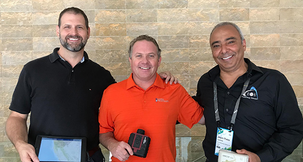
    From left: Esri Program Manager Doug Morgenthaler, Laser Technology Sr. Product Manger Derrick Reish and Eos CTO Jean-Yves Lauture.(Photo: Eos Positioning)
    From left: Esri Program Manager Doug Morgenthaler, Laser Technology Sr. Product Manger Derrick Reish and Eos CTO Jean-Yves Lauture. (Photo: Eos Positioning)

    The three-way partnership will enable field crews to collect centimeter-accurate 3D data in GNSS-impaired environments.

    GNSS receiver maker Eos Positioning Systems has released a laser offset solution within the Esri Collector for ArcGIS workflow.

    When combined with Laser Technology Inc.’s (LTI’s) laser rangefinders, the solution will allow field crews to capture centimeter-accurate 3D locations of hard-to-reach assets and in GNSS-impaired environments.

    “By combining the high-accuracy of the Eos Arrow Series GNSS receivers and the laser capabilities of LTI, we can empower field crews to capture highly accurate XYZ coordinates from a safe distance,” LTI Senior Product Manager Derrick Reish said. “This eliminates the need for physically occupying every point. It also provides more accurate location data, with a more affordable mobile asset-management workflows.”

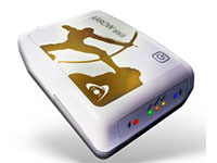
    The Arrow Gold. (Photo: Eos Positioning)
    The Arrow Gold. (Photo: Eos Positioning)

    The solution has been in the works for months, as demand has grown for hard-to-reach, high-accuracy mapping within the Collector workflow.

    “Eos is extremely grateful to be a part of this initial release in high-accuracy asset location data with LTI’s laser rangefinders and Esri’s Collector mobile app,” Eos CTO Jean-Yves Lauture said. “Enabling this kind of accuracy means even the most budget-conscious field crews will be able to access the location of their hard-to-reach assets.”

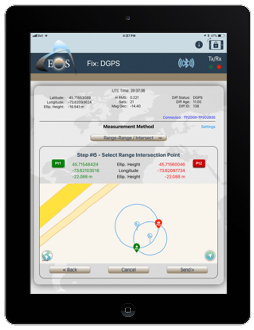
    All three teams have been working closely to ensure a seamless integration with Collector and ArcGIS Online. When using an LTI laser rangefinder and an Eos Arrow Series receiver with Collector, a field worker can easily shoot, capture and share high-accuracy 3D location data that is streamed into ArcGIS Online in real-time.

    Image: Eos Positioning
    Image: Eos Positioning

    The solution is expected to be particularly useful in urban corridors, highway settings, forested (or wetlands) areas, and other areas where assets are hard or dangerous to occupy. This will both increase accuracy and efficiency, as well as decrease safety liabilities in dangerous situations, the companies said.

    “Esri is extremely pleased that Collector can now support the capture of high-accuracy asset locations from afar, leveraging our unique partnership with both Eos and LTI,” Esri Product Manager Jeff Shaner said. “This is a game changer for asset management.”

    Prior to this release, field crews challenged with capturing high-accuracy 3D locations for hard-to-reach assets would need to use a total station with a different software workflow and then mesh the data back in the office, a clumsy and inefficient workflow requiring lots of additional training and expertise. With the new workflow, field crews can operate in GNSS-impaired environments at a high-accuracy level without leaving the Collector/AGOL environment, creating a highly efficient workflow.

    The solution has been designed to provide several offset-mapping methods.

    “The implementation of several measurement methods gives users the freedom of choice, so they can pick the right laser option which meets their accuracy needs,” Reish said.

    Eos will unveil its offset measurement solution for Collector at the upcoming Esri User Conference in San Diego. For a field demonstration of how the solution works, attendees can visit Eos at booth #1019 during the conference, and attend the session “LaserGIS for Everyone: How to Combat Costly and Tedious Data Collection Workflows” at 10 a.m. on Wednesday.

  • EU initiative achieves greater airport safety with 3D GNSS

    EU initiative achieves greater airport safety with 3D GNSS

    The European Union (EU) project BLUEGNSS has been developing GNSS applications in selected European airports to increase safety and airport accessibility, according to the European Commission’s Community Research and Development Information Service (CORDIS).

    BLUEGNSS’s focus has been on advancing the adoption of the Galileo system in Greece, Italy, Cyprus and Malta. The four countries together form the Blue Med functional airspace block (FAB): airspace in which air traffic is managed irrespective of national boundaries. Blue Med is one of the nine FABs formed in Europe to reduce the fragmentation of the European air traffic network.

    Three-dimensional GNSS approaches are being designed for 11 airports in the Blue Med FAB: four each in Greece and Italy, two in Cyprus and one in Malta.

    The primary aim is to harmonize the implementation of required navigation performance approaches among the four countries, CORDIS said. This will enable aircraft to fly along precise flight paths with greater accuracy, and will make it possible to pinpoint aircraft position with precision and integrity.

    Three new procedures. So far, substantial progress has been made towards safety and airport accessibility in the target countries. Since the beginning of 2018, three new GNSS procedures have been validated for Italian airports Cuneo, Lamezia and Parma, followed by another two for Larnaca and Paphos in Cyprus.

    The poor weather conditions under which the Cyprus GNSS approaches were validated served to demonstrate the benefits of GNSS vertical guidance. Since its launch in 2016, BLUEGNSS has designed and validated 14 GNSS procedures.

    Augmented performance of Galileo has been achieved through the European Geostationary Navigation Overlay Service (EGNOS). EGNOS is a satellite-based augmentation system that improves GNSS positioning. Its three satellites and network of more than 39 reference stations in 24 countries enable it to provide greater accuracy than Galileo alone.

    EGNOS’s safety advantages and lower investment costs greatly benefit small and regional airports, which usually can’t afford the high costs of installing and maintaining ground-based navigation aids.

    For this reason, BLUEGNSS has promoted its use in this geographically challenging Mediterranean region.

    “The southeast Mediterranean region lacks full EGNOS coverage,” said GNSS expert Patrizio Vanni of ENAV S.p.A., project coordinator and Italy’s air navigation service provider. “To make things even more challenging, each airport involved in the project presents a very different operational environment.”

    The project hasn’t only focused on designing and validating GNSS approaches at airports where no such procedures have been available up to now. It has also provided the necessary training and monitoring to support implementation by the Blue Med FAB countries.

    Now close to completion, BLUEGNSS (Promoting EGNSS Operational Adoption in Blue Med FAB) is the first project of its kind to be coordinated at FAB level. It may serve as a catalyst to spread required navigation performance approach know-how in the region and beyond, to the whole of Europe.

    (Photo: EU)

  • Comtech awarded automotive navigation contract

    Comtech Telecommunications Corp. has been awarded $1.9 million navigation contract by a U.S. automotive manufacturer, according to the company. The automaker’s identity was not revealed.

    The contract is with Comtech’s Enterprise Technologies group, which is part of Comtech’s Commercial Solutions segment, and is for developing a new navigation product for two of the automaker’s top vehicle programs, including motorcycles.

    “With this agreement, our turnkey navigation solution will be introduced to an entirely new automotive segment and is included as a lead product for this manufacturer supporting multiple languages and is deployed globally across all major markets,” said Fred Kornberg, president and chief executive officer of Comtech Telecommunications Corp. “It also represents a new stage of growth for our navigation and mapping applications, made possible through our Location Studio platform that has been a leading source of product customization for OEMs across a number of vertical markets.”

    The Enterprise Technologies group specializes in precise device location and messaging platforms. Its fully virtualized and API solutions are available to mobile network operators, enterprises, internet of things (IoT) developers and automotive manufacturers.

    Comtech Telecommunications Corp. designs, develops, produces and markets innovative products, systems and services for advanced communications solutions. It sells products to a diverse customer base in the global commercial and government communications markets.