By Gustavo Lee and Mathieu Joerger, Aerospace and Mechanical Department, The University of Arizona Presented at ION/IEEE/PLANS 2018
This paper describes the design and implementation of a new safety risk evaluation method for a sensor-based automotive collision warning system using vehicle-to-vehicle (V2V) communication. It provides an overview of the V2V basic safety message (BSM) format and of surrogate measures of safety (SMS) used to parameterize a vehicle encounter. BSM and SMS are then employed to quantify risk of collision and risk of false alerts. Preliminary simulations illustrate the methodology in an example multi-sensor intersection movement assist system.
The U.S. Federal Communications Commission has allocated 75 MHz of licensed spectrum in the 5.9-GHz band for use by Intelligent Transportation Systems vehicle safety and mobility applications. In addition, in the Society of Automotive Engineers (SAE) J2735 Standard, the DSRC committee specifies a set of messages and their formats to support vehicle-based applications. Of particular relevance to this work is the BSM, which conveys critical vehicle-state information that includes vehicle position, positional accuracy, speed, heading, braking status and size.
V2V communications using DSRC have an operational range of about 300 meters. Within this range, V2V applications have the potential to significantly reduce occurrences of crashes through real-time advisories, alerting drivers to imminent hazards. GPS and GPS/INS-based relative positioning using V2V is subject to alteration and loss of GPS signal. But unlike vehicle-resident sensors (such as cameras and lidars), GPS/INS/V2V is not affected by weather, light or dust, and can sense out-of-sight vehicles occluded behind other vehicles or around building corners. This capability addresses scenarios where an oncoming vehicle emerges from behind a truck or from a blind alley. In those situations, GPS/INS /V2V can sense threats that a radar or camera cannot.
The SensLynx GPS Management Accelerator Program (GMAP) can enable start-ups or enhance existing business portfolios with the addition of tracking solutions, the company said.
GMAP requires no upfront investment or inventory warehousing, and is structured to deliver recurring revenue via new sales channels, while also being compatible with legacy business models to capitalize on similar customer profiles.
Because SensLynx white labels its solutions under certain criteria, entrepreneurs earn significant margin on hardware sales, plus monthly subscription income from the customers they will own outright.
“We believe in the entrepreneurial spirit,” said Rob Garry, co-founder and CEO of SensLynx. “Not only does this Accelerator Program help us grow our IoT Fleet sector on a grass roots level, it inspires others to strike out on their own or expand.”
The GMAP program is built around SensLynx’s bundled solution components, which include Fleet & Asset Tracking, Electronic Logging Device, Routing Application, Video/DashCam capture and Workforce Management for smartphones.
At its heart is comprehensive fleet/asset tracking software, packed with features like data handling, parsing, database, mapping, alerting, reporting, dispatch, maintenance logging, e-logs, local posted speed limits, addressing, geofencing, interstate miles, open API-based software and more.
The complete bundled solution with software, hardware and data connectivity is packaged at one guaranteed monthly price.
Senslynx’s GMAP program includes initial training, planning for rollout, conducting telemarketing for launch, developing website content, providing custom-branded marketing materials and online demo support, accessible through the streamlined GMAP Reseller Portal where businesses can also easily manage supply chain and customer accounts.
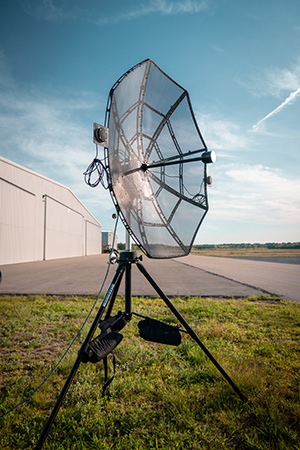
Designed to incorporate aircraft into the MANET, the Auto-Tracking Antenna System is a complete portable ground-to-air system for tracking aircraft, including drones. Army, Navy and foreign customers can use it for better airborne communications relay and full-motion video camera/sensor data transmission, Persistent said.
Photo: Persistent Systems
“The Auto-Tracking Antenna System represents a major step towards achieving the vision of a truly networked battlefield,” said Herb Rubens, CEO of Persistent Systems. “The tracking antenna rotates to follow air assets, keeping them connected to the MANET. “The air platforms orbit over our users on the ground, extending the MANET bubble and keeping soldiers connected to the enterprise. High throughput, low latency connectivity empowers the warfighter and decreases the dependence on SATCOM, which both reduces cost and increases network availability.”
Designed for ease-of-use, quick assembly and portability, the Auto-Tracking Antenna System can be assembled and deployed in less than 15 minutes, the company added.
The portable and lightweight design is completely collapsible, with the main five-foot parabolic dish breaking down into eight individual petals.
The entire system fits into most standard-sized SUVs for easy transport and compact storage.
Photo: Persistent Systems
Mimicking the MPU5’s modular RF structure, the Auto-Tracking Antenna System has interchangeable S-band, L-band and C-band MIMO feeds that allow it to cover all frequencies where Persistent’s five radio modules operate.
The antenna feeds twist-lock into place for quick and simple installation. An Automatic Heading System enables the tracking antenna to self-calibrate prior to operation for greater precision and less than one-degree pointing accuracy.
“Our customers require a system that is simple to put together, turn on, and works,” said Louis Sutherland, vice president of business development at Persistent Systems. “They want to extend the Wave Relay MANET out to aircraft and achieve high data-rates and reliable HD video transmission. The Auto-Tracking Antenna System truly delivers.”
The large parabolic dish enables video streaming out to distances of 130 miles (over 200 kilometers) while maintaining high throughput and strong signal strength.
Photo: Persistent Systems
Combining the precisely aimed tracking system with the MPU5 radio and Wave Relay MANET achieves optimal connectivity and reliable communications for manned and unmanned aircraft to communicate further than ever before.
The antenna is IP67 rated and built to endure harsh environments and weather, so it can be setup and left out for as long as the mission requires.
Who better to know about connections than a GIS professional whose very job is discovering them? Weaving a thread through time from decades ago isn’t a typical geospatial connection, but this one is, and it is connected by a person.
Let’s reflect on who we are as a profession and how we, the geospatial community, has made the world a better place.
Let’s also take a moment to learn about one of the leaders who led the way and what he had to overcome to help us appreciate who and what we are. It is an oft-repeated refrain: “Those who do not know the past are condemned to repeat it”, and, my personal favorite, “The future flows through us becoming the past so that we remember it and do not repeat it.”
Jack Maple. (Photo: Newsday Photo, 1986 / Bruce Gilbert)
In 1961, the trend in crime began climbing. Many people lived in fear, especially in big cities. New York captured many of the nation’s headlines in a long, tragic list of brutal, horrible crimes. Hope was bleak. It was expected to get worse. But, it didn’t. The fever had broken. It peaked in 1991. The crime spree lasted 30 years.
By contrast, the Vietnam War lasted 20 years. The total number of troops serving on active duty during Vietnam was 9.1 million troops and 58,318 lost their lives in combat, yet fewer people died on the streets of America during the same period. In fact, on average, during the 30-year crime wave, every 22 days the number of victims of violent crime in the United States equaled the total number of soldiers killed in Vietnam. America was a battlefield and ground zero was New York City.
What happened in 1991? What stemmed the tide? That year, a new type of hero emerged, a crime fighter, unlike any before.
It began at ground zero, in the most dangerous areas of New York City — the subways, referred to as the “caves.” Thugs, rapists, murders and thieves roamed the depths. Police could do little. They were outnumbered and operated under strict rules. It was preferable to be a regular police officer, above ground, dealing with routine crimes, even the murders, rather than be a transit cop covering a beat in the dark, rough, unforgiving underworld of the subway. Only four types of people dwelled there: criminals, victims, transit cops, and those who got away.
Sometimes, transit cops or criminals were the victims. Transit cops were difficult to recruit, but New York needed more of them. This provided an opportunity for those with few other choices. Sometimes, those who have no other options are the ones who make the most of an opportunity. They work the hardest because it is their only way out. Success lies with the willing — those incendiary hearts waiting to be ignited by a challenge that gives them purpose. Life is too often fraught with peril and strife. It is vision and the courage to pursue them that manifests dreams into reality.
This new hero didn’t fit the caricature. He was short, balding, overweight and lacked a high school diploma. He was street smart, cocky, unpolished and would rather fight than prove his point. He didn’t come from a privileged background. He just had his wits. He knew right from wrong and had the courage to stand his ground. He took on the criminal element lurking in the subterranean worlds. He worked hard, earning his GED at night. It served him better that way like a badge of honor, the hard way being its own reward.
His name was Jack Maple, the crime fighter, and he understood the streets in ways others didn’t. He knew, like a hunter knows, to find the deer trails. Animals are creatures of habit. They prefer to stay where they know the area, the smells, the rhythms, the sounds, where the food is, and where to run for cover. Criminals measure their risks too. They prefer familiar places. They are territorial and keen to their surroundings. Jack knew if you look for their patterns, you’ll find them. He covered his walls with subway maps, placing pins where and when the crimes happened.
The criminal’s habits and behaviors began taking shape. With this knowledge, Jack had become the hunter. Knowledge is power, but real power is action, and Jack took it. He would not have become the hero otherwise. He staked out their patterns of place and time, setting traps and luring them in with their weaknesses.
One by one, and group by group, he reclaimed New York’s subways. Crime dropped by 69% over the next five years. Putting that in perspective, two of every three victims were spared. Unfortunately, 629 people were still murdered in New York City, but it was a drastic departure from the peak of 1,946 just five years before, meaning 1,317 men, women and children did not suffer a violent crime that year or any other year thereafter.
The values of crime are most often represented as a 1:100,000 scale ration; however, this chart shows three different categories, each represented by a different order of magnitude. (Data from Disastercenter.com)
Rudy Giuliani, then mayor of New York, recognized the value of what Maple had developed. Maple called his maps the Charts of the Future. His colleagues called it wallpaper. The mayor called it amazing and gave Jack Maple his full support, praising him by saying, “One of the truly great innovators in law enforcement, who helped make New York City the safest large city in America.” Maple was promoted to Deputy Police Commissioner of Crime Control Strategies.
Maple founded CompStat, Computerized Statistics, calling it his electronic pin maps to support his four precepts: accurate and timely intelligence, rapid deployment of forces, effective tactics, and relentless follow-through.
New York’s CompStat program for the NYPD.
CompStat changed policing to a data-driven business. GIS professionals will recognize CompStat as a geographic information system, and Jack as a self-trained geospatial developer and analyst. Geospatial science was still a very niche technology at the time.
Jack Maple’s success continued to grow. Two men, William Bratton and John Timoney, both police commissioners and senior to Maple in the police hierarchy, became evangelists of Maple’s CompStat, spreading it to other cities throughout the world, and through those two men, predictive policing and crime mapping evolved.
Maple, Bratton and Timoney became independent consultants helping cities worldwide establish their own CompStat programs.
His success did not end there. Based on his experiences fighting criminals on the streets and fighting change in the antiquated police system, he wrote the book, The Crime Fighter: How You Can Make Your Community Crime Free. The book is an excellent read and readily available online. He also co-wrote the TV series The District, based on his exploits in the book.
If you haven’t seen the series, the show is worth watching. Season 1, Episode 3, shows a 1990s projector screen with a large GIS display and the city’s police chiefs being held to account for telling their district’s crime stories in accordance with the map.
Jack Maple was a modern-day rags to riches story and a pioneer of the GIS profession. When he passed away in 2001, he had become a beloved character in New York. When he died, each of the major New York City publications covered the story of his life crediting him for reducing crime and giving the citizens back their city. The CompStat room at 1 Police Plaza CompStat, New York, was renamed after him in tribute. Craig Horowitz, writer for New York Magazine, penned a worthy tribute.
CompStat would be further developed with more advanced crime mapping and crime analysis methods, predictive analytics, environmental criminology and geographic profiling. Kim Rossmo coined the term geographic profiling, based on his patented Rossmo Formula, which is a form of predictive analytics that takes location, time, social behavior and the psychology of criminals into account and turns it into a mathematical equation that can be fed into a GIS. This narrows down the probable location of a suspect, allowing investigators and police to better focus their resources.
Geographic profiling was used during the D.C. sniper case. The Rossmo Formula was featured on the TV series Numb3rs. I hope to write a future article on Dr. Rossmo complete with interviews.
The trend in crime has continued decreasing ever since the peak in 1991. Crime in New York City has now dropped back to 1940s levels as of 2017 and continues to decline.
The power to change the world lies with those fervent, intrepid souls — the unrelenting dreamers, who seek a better world and through innovation, creativity and courage, and manifest it into reality.
It is a great time to be in the geospatial profession. The United States leads the world in geospatial science. Take heart, because opportunities abound in this industry. I hope you become a hero in the field, and someday I have the opportunity to write about you.
Harris Corporation has been awarded three multi-award indefinite delivery/indefinite quantity (IDIQ) contracts with ceilings totaling $1.5 billion to provide the National Geospatial-Intelligence Agency (NGA) with geospatial data services for up to 10 years.
Harris will create, manage and disseminate high-quality geospatial-intelligence (GEOINT) information for use by the U.S. intelligence community and military worldwide under contracts that cover all three areas of NGA’s JANUS program — geography, imagery and elevation.
The JANUS program will contribute to and maintain comprehensive, geospatially accurate databases of the world that can be accessed quickly as intelligence, operational and crisis needs arise.
Harris will use its predictive analytics technology to continuously evaluate the health of NGA databases and to guide the acquisition, creation and integration of all forms of geospatial data. Harris’ cloud-based tools will validate and correct the data — pinpointing locations that require updates.
“Winning JANUS continues our long-standing legacy of providing high-quality, responsive GEOINT and analytics to the intelligence and military communities,” said Bill Gattle, president, Harris Space and Intelligence Systems. “Our analytics technology provides NGA with fit-for-purpose data, reduced production costs and cloud-based access to geospatial products and content.”
Harris is investing in new technologies that improve the speed and accuracy of providing GEOINT products. The company has partnered with the NGA for almost 20 years to provide automated geospatial data processing, data management, and geospatial systems design and development. Harris provides high resolution geospatial data content and products under NGA’s Foundation GEOINT Content Management program, and previously supported the Global Geospatial-Intelligence program.
Hexagon US Federal Also Contracted
The NGA also has selected Hexagon US Federal as a prime contractor on two multiple award, indefinite delivery/indefinite quantity contracts for amounts totaling $1.17 billion for the JANUS Geography and JANUS Elevation contracts.
JANUS Geography. Hexagon’s tasks for the JANUS Geography program will support the creation, conflation, integration and enrichment of Foundation GEOINT data used to produce a comprehensive and seamless dataset for NGA partners and customers.
The creation of this dataset will ensure more accurate and readily available geospatial data for military and intelligence operations as well as disaster relief missions saving time and lives.
JANUS Elevation. As a prime contractor on the JANUS Elevation contract, Hexagon will support NGA’s Office of Geomatics with maintenance to an existing worldwide library of digital elevation models. The effort includes products generated, modified or assessed by the office that are a digital representation of the terrain surface of the Earth.
A news story from Australia’s “Today Tonight Adelaide” television show highlights how the DroneShield system can bring down drones that enter restricted airspace or threaten safety. DroneShield countermeasures allow for the controlled management of drone payloads such as explosives, with no damage to common drone models or the surrounding environment.
An F/A-18F Super Hornet assigned to Strike Fighter Squadron (VFA) 102 launches from the flight deck of the aircraft carrier USS Ronald Reagan on July 10, 2018. (Photo: U.S. Navy/ Mass Communication Specialist 2nd Class Kenneth Abbate/Released)
Along with partner L3 Technologies, the Enhanced Link Navigation System (ELNS) offers new solution to defeat enemy countermeasures to detect and disrupt allied signals.
CTSi and partner L3 Technologies this month completed flight-testing of a newly developed integrated communication and navigation system for use in highly contested and GPS-denied environments.
Designated the Enhanced Link Navigation System (ELNS), the prototype was built under a U.S. Navy $8.7 million Small Business Innovative Research (SBIR) Phase III contract and flight tested at the St. Mary’s County Regional Airport near Patuxent River, Maryland.
“Our team put ELNS in the air in less than 18 months. It worked the first time and every time during 15 flights, which included 152 approaches,” said Ian Gallimore, CTSi chief technology officer. He went on to say that ELNS provided area navigation to replace GPS at ranges in excess of 50 nautical miles all the way through landing.
Pilots from Airtec, who provided turn-key flight test support, said during test events, “These needles are… money,” and “ELNS is as good as any instrument landing system I’ve flown, I’d fly it in the weather.”
“ELNS is scalable for unmanned aircraft in all groups, from those needing high integrity like MQ-25, to small unmanned aircraft on tight weight budgets,” said Martin King, Navy project manager. “ELNS is the first system to bring GPS-denied navigation capability to small UAS. By combining significant investments in related fields to create a whole new capability like this, ELNS takes position, navigation and timing (PNT) for air vehicles in a compelling new direction.”
ELNS utilizes L3 Technologies’ waveforms that defeat adversary strategies to detect and disrupt allied signals, using waveforms that are essential in communications-denied and GPS-denied environments.
“There is a strong fit between what ELNS brings and the threats that our forces are facing today,” said Tom Sanders, CTSi chief executive officer.
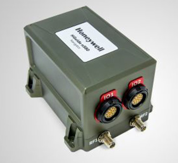
Honeywell has produced a new inertial navigation unit that provides accurate navigation for customers across a broad range of industries including agriculture, robotics and autonomous vehicles, without compromising on size, cost or performance.
The HGuideN580 inertial navigation technology improves accuracy in urban and rural environments. (Photo: Honeywell)
The HGuide n580 is the first Honeywell-produced, industrial-focused navigation solution that uses both precision inertial measurement unit technology and GNSS to improve location accuracy even when facing natural and manmade obstacles.
“The blend of inertial and satellite navigation capabilities provided by the HGuide n580 is especially important where precision is required in demanding environments — for example, autonomous cars traveling in cities, where our technology can extend the accuracy and performance of navigational systems while keeping passengers safe,” said Chris Lund, senior director, Navigation and Sensors, Honeywell Aerospace. “Honeywell’s history and expertise in navigation technology enables customers to implement this new wave of advanced technology into their own applications and operations.”
Roughly the size of a deck of cards, the HGuide n580 gives Honeywell’s industrial customers the capabilities needed to navigate accurately in areas with limited satellite coverage, such as densely populated cities where tall buildings, underground tunnels, and multi-layer freeway stacks or bridges often create challenges to traditional GPS navigation.
For a GPS unit to function properly, it requires a strong signal connection between the unit on the ground and multiple satellites in the sky to accurately orient its position. City infrastructure such as buildings and tunnels can temporarily block the signal between GPS unit receivers and satellites, creating urban canyons.
With the HGuide n580 integrated system, Honeywell’s inertial measurement unit technology combines with GPS to act as a backup solution, which means the loss of GPS signal caused by an urban canyon does not result in a complete loss of navigation.
To learn more about the new HGuide n580 solution and Honeywell’s other commercially available navigation technologies, visit the Honeywell Aerospace website.
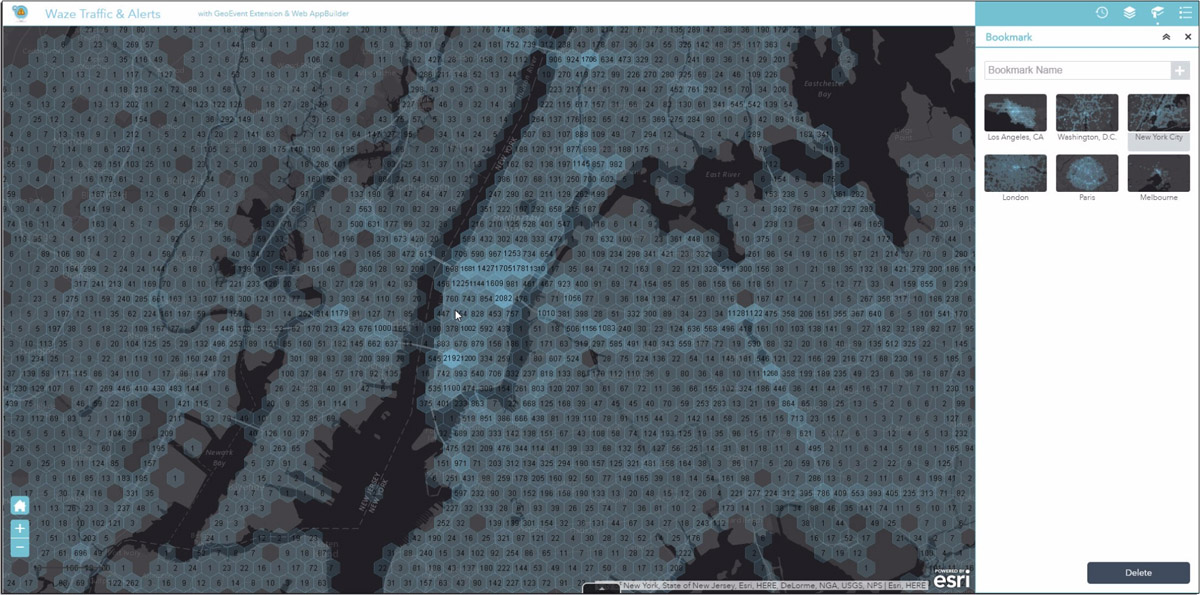
The Connected Citizens Program, a two-way sharing of publicly available traffic and road condition information, offers governments a stream of data, constantly updated in real-time, whenever they need it. This enables personnel to make data-driven infrastructure decisions and improves the efficiency of incident response.
Waze, a free crowdsourced traffic and navigation app, is now fully supported by ArcGIS Online, where its live feed of mapped traffic alerts and other information, such as accidents, congestion and street damage, can be used in applications in minutes.
“Municipalities can now leverage near up-to-the-minute reports without having to write code or purchase additional software,” said Andrew Stauffer, manager of civic technology at Esri. “Mapped Waze data is available immediately in all ArcGIS apps, where traffic engineers and even city planners can use it to maintain and build safer, more efficient transportation systems.”
Municipal personnel like traffic engineers can start using this data to analyze where the biggest problems exist on the roads so they can create targeted solutions. For instance, by seeing exactly where the most crashes are occurring, engineers can know where they need to place more officers, replace street signs, or adjust the timing of traffic lights.
“The Waze Connected Citizens Program is all about removing any barriers to innovation,” said Adam Fried, Waze Global Partnerships manager. “We want to help our partners leverage existing infrastructure and be able to make better data-driven decisions. Now, with just a couple of clicks, a city can easily access and analyze Waze data within Esri ArcGIS and use those insights to improve roadway management and build safer roads for its citizens.”
Much of the information government organizations rely on to make decisions is becoming obsolete as communities are starting to use technology like sensors and drones to monitor the quality of roads, bridges, and utilities. The Waze Connected Citizens Program gives municipalities the power to harness crowdsourced driver data to not only improve safety and congestion but also make better-informed decisions by giving planners an edge to start building infrastructure that meets the demands of a twenty-first-century city.
Governments can sign up for the free Waze Connected Citizens Program and start working with the alert data in ArcGIS to create operational dashboards that departments can use right away.
The Association for Unmanned Vehicle Systems International (AUVSI) has formed an Unmanned Maritime Systems (UMS) Advocacy Committee to focus on the development of policy positions to support the advancement of the industry.
“Unmanned maritime systems allow military and commercial operators alike to go farther and deeper than ever before,” said Brian Wynne, president and CEO of AUVSI. “The input provided by the UMS Advocacy Committee will help us speak with a unified voice and enable all our members to advocate for the growth of the industry.”
The UMS Advocacy Committee will be chaired by Thomas Reynolds, vice president of business development for Hydroid Inc./Kongsberg Maritime. Reynolds, who leads all Kongsberg Maritime business with the U.S. government, previously served as a commissioned officer in the U.S. Navy, where he served as commander of the Explosive Ordinance Disposal Task Group, U.S. Fifth Fleet, among other roles.
Reynolds holds a bachelor of science degree from the U.S. Naval Academy and an executive master of business administration from Benedictine College.
Wayne Prender, vice president for Applied Technology and Advance Programs at Textron Systems, will be the committee’s vice chair. In his role at Textron, Prender is responsible for engineering development programs, advancing areas such as the Common Unmanned Surface Vehicle and Cased-Telescoped Weapons and Ammunition, as well as emerging capabilities and development programs.
Prender is a former commissioned officer in the U.S. Army, where he was deployed to Iraq and awarded the Bronze Star. He holds a bachelor’s degree in mechanical engineering from St. Louis University, a master’s degree in technology management and a master of business administration from the University of Maryland University College.
The committee also includes representatives from BAE Systems, L3 Technologies, Leidos, Lockheed Martin, Northrop Grumman and Seaborn Defense.
The UMS Advocacy Committee formalized a set of policy priorities to help guide the committee’s legislative and regulatory actions. The priorities state that the committee shall:
Establish the UMS Advocacy Committee as the preeminent industry voice influencing acquisition and regulatory policies and processes.
Facilitate the growth of UMS through active engagement with the government and commercial sectors.
Collaborate with ship owners, operators, shipyards, ports, federal maritime agencies, technology developers, classification societies and academia to further integrate advanced automation for maritime platforms into the domestic market.
Develop the future of the UMS workforce through technology-focused education.
STMicroelectronics has introduced the automotive-grade ASM330LHH six-axis inertial sensor for super-high-resolution motion tracking in advanced vehicle navigation and telematics applications.
Photo: STMicroelectronics
Serving demands for continuous, accurate vehicle location to support automated services, the ASM330LHH lets advanced dead-reckoning algorithms calculate precise position from sensor data if satellite signals are blocked, such as in urban canyons, tunnels, covered roadways, parking garages or dense forests.
Its advanced, low-noise, temperature-stable design enables dependable telematics services such as e-tolling, tele-diagnostics and e-Call assistance. Precision inertial data in six axes also meets the needs of advanced automated-driving systems, the company said.
Automotive component manufacturer Magneti Marelli has selected the ASM330LHH for advanced telematics systems, to be fitted as original equipment by global automotive groups in upcoming vehicle ranges.
For the ASM330LHH, as with all its MEMS sensors, STMicroelectronics owns the entire manufacturing process, from designing the sensors, through wafer fabrication, packaging, test, calibration and supply. Full end-to-end control enables STMicroelectronics to create high-performing sensors and assure customers of a robust and responsive supply chain, with rigorous end-of-line quality screening, the company said.
“STMicroelectronics is the largest supplier of MEMS sensors for automotive non-safety applications, such as navigation and telematics,” said Andrea Onetti, Analog, MEMS and Sensors Group vice president at STMicroelectronics. “Our latest-generation inertial sensor, the automotive-grade ASM330LHH, enables precise positioning for safer, smarter driving.”
Engineering samples will be available for evaluation by the third quarter of 2018, and volume production will begin the following quarter.
Further technical information on the ASM330LHH
Temperature range up 105 degrees Celsius giving designers extra freedom to locate electronic controls in hot areas such as in smart antennas on the vehicle roof, or near the engine compartment.
Ultra low noise allows greater measurement resolution by minimizing integration errors when positioning is reliant on sensors only.
High linearity and built-in temperature compensation eliminate any need for external compensation algorithms over its operating range.
Lowest power consumption in class, with features for optimizing power management if battery usage becomes crucial.
Qualified according to AEC-Q100 automotive-grade robustness standard.
Built on STMicroelectronics’ proven, proprietary ThELMA MEMS process technology, which enables integration of both the three-axis accelerometer and three-axis angular-rate sensor (gyroscope) on the same silicon for optimum yield, quality, and reliability.
The electronic interface integrates the signal chain for both sensors on a single die using STMicroelectronics’ 130nm HCMOS9A technology.
Reference designs, as well as STMicroelectronics’ Teseo satellite-positioning modules and related software are available. The dead-reckoning algorithm included with the Teseo III GNSS-receiver chipset already supports the ASM330LHH to generate a high-accuracy output suitable for autonomous navigation.
Tiny, low-profile 3mm x 2.5mm x 0.83mm device for minimal impact on the size of any on-board module.
Packaged as a leadless Land Grid Array (LGA) device.
East View Geospatial (EVG) is offering a new version of MapVault, a streaming service that brings together maps from around the world.
According to the company, MapVault provides access to more than 500,000 geo-referenced map sheets from more than 1,000 authoritative map series, which can save organizations the costs of procuring, storing and digitizing physical maps.
MapVault users have access to a diverse collection of topographic, aeronautical, nautical and geological map series sourced from international mapping agencies. Each series has been mosaicked for easy use and quick navigation. Robust metadata along with series index maps and individual sheet-level metadata are included.
New map series are added to MapVault on a regular basis, and subscriptions are customizable. Users can choose to subscribe to the series that cover their exact areas of interest or select from multiple regional package options.
East View Geospatial also provides custom series solutions and encourages users to contact the company about adding their own mapping resources to the MapVault platform.
MapVault was designed for a wide variety of users, both GIS and non-GIS specialists, and data is easily integrated into GIS software, the company said. The MapVault catalog can be accessed over the internet or through any WMTS (web mapping tile services) connection. Layer files formatted specifically for ArcGIS Desktop, QGIS, Global Mapper or other open-source GIS packages can be downloaded.
“What makes MapVault unique is the many advantages it brings to users,” said Kent Lee, president and CEO of East View Geospatial. “We’ve taken the time and cost out of tiling entire map series, giving users consistent, reliable data served up in a straightforward, easy-to-use streaming service. Whether you are interested in global or country-wide mapping coverage, or even county- or city-level mapping, MapVault gives users of all experience levels a simple and accessible environment in which to discover and utilize maps.”



 His success did not end there. Based on his experiences fighting criminals on the streets and fighting change in the antiquated police system, he wrote the book,



 MapVault users have access to a diverse collection of topographic, aeronautical, nautical and geological map series sourced from international mapping agencies. Each series has been mosaicked for easy use and quick navigation. Robust metadata along with series index maps and individual sheet-level metadata are included.