Category: Applications

  • New DoD policy prohibits personal GPS tracking in deployed settings

    News by Jim Garamone, U.S. Department of Defense

    Deployed service members may have to ditch their fitness trackers in response to a new memo from Deputy Defense Secretary Patrick M. Shanahan prohibiting the use of GPS functions in deployed locations.

    This includes physical fitness aids, applications in phones that track locations, and other devices and apps that pinpoint and track the location of individuals.

    Pentagon spokesman Army Col. Robert Manning III announces the policy on geolocation devices at the Pentagon, Aug. 6, 2018. (Photo: DoD/Jim Garamone)
    Pentagon spokesman Army Col. Robert Manning III announces the policy on geolocation devices at the Pentagon, Aug. 6, 2018. (Photo: DoD/Jim Garamone)

    “Effective immediately, Defense Department personnel are prohibited from using geolocation features and functionality on government and nongovernment-issued devices, applications and services while in locations designated as operational areas,” Pentagon spokesman Army Col. Robert Manning III told Pentagon reporters on Aug. 6.

    Deployed personnel are in “operational areas,” and commanders will make a determination on other areas where this policy may apply.

    The market for these devices has exploded over the past few years, with many service members incorporating them into their workout routines. They use the devices and applications to track their pace, running routes, calories burned and more. These devices then store the information and upload it to central servers where it can be shared with third parties. That information can present enemies with information on military operations.

    Using GPS Devices Pose Risk

    Photo: Fitbit
    Photo: Fitbit

    “The rapidly evolving market of devices, applications and services with geolocation capabilities presents a significant risk to the Department of Defense personnel on and off duty, and to our military operations globally,” Manning said.

    The GPS capabilities can expose personal information, locations, routines and numbers of DoD personnel. Their use in overseas locations “potentially create unintended security consequences and increased risk to the joint force and mission,” Manning said.

    Personal phones and other portable devices also contain apps that rely on GPS technology, and they will be affected. Commanders will be responsible for implementing the policy, and they will be allowed to make exceptions only after conducting a thorough risk assessment.

    Security is at the heart of this guidance. DoD seeking a balanced way that allows for legitimate official and personal uses of geolocation technology that does not impact security.

    Manning said the department will continue to study the risk associated with these devices and change the policy as needed.
  • Commuter rail industry tracks progress on positive train control

    Commuter rail industry tracks progress on positive train control

    The commuter rail industry is making progress installing and implementing positive train control (PTC), according to an analysis by the American Public Transportation Association (APTA), an advocate for the advancement of public transportation programs and initiatives in the United States.

    The advancements reflect the commuter rail industry’s commitment to safety and implementing PTC by the Dec. 31 statutory deadline, APTA said in a statement.

    PTC is a complex signaling and communications technology that commuter rail agencies are installing to offer a critical safety overlay on top of an already safe industry. In fact, rail is the safest surface transportation mode and traveling by commuter rail or intercity rail is 18 times safer than traveling by automobile.

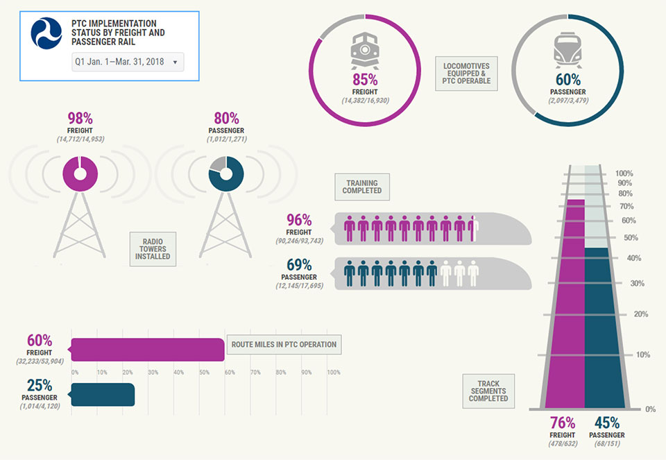
    The Federal Railroad Administration issued a PTC progress report in July, with the infographic below.

    Chart: Federal Railroad Administration, Jan-March 2018
    Chart: Federal Railroad Administration, Jan-March 2018

    This is in contrast to a previous PTC infographic, released in June 2016.

    Chart: Federal Railroad Administration, June 2016
    Chart: Federal Railroad Administration, June 2016

    According to APTA, as of June 30, 2018:

    • 91 percent of spectrum has been acquired;
    • 85 percent of 13,698 pieces of onboard equipment have been installed on locomotives and cab cars etc.;
    • 79 percent of 14,083 wayside (on track equipment) installations have been completed;
    • 78 percent of back office control systems are ready for operation;
    • 74 percent of 14,847 employees have been trained in PTC; and
    • 34 percent of commuter railroads are in testing, revenue service demonstration, or are operating their trains with PTC.

    “Every year, 30 commuter railroads across America safely carry passengers on 501 million trips,” said APTA President and CEO Paul P. Skoutelas. “With safety as our number one priority, the commuter railroads are making strong and continuous progress in implementing Positive Train Control.”

    Under current law (49 U.S.C. 20157), commuter railroads are required to meet the following milestones by Dec. 31. As defined in 49 U.S.C. 20157(a)(3)(B), they are to have:

    • Installed all PTC hardware (wayside and onboard equipment);
    • Acquired all necessary spectrum for PTC implementation;
    • Completed all employee training;
    • Initiated testing on at least one territory subject to the PTC requirement (or other criteria); and
    • Submitted a plan and schedule to the Secretary of Transportation for implementing a PTC system.

    Upon reaching these milestones by the end of 2018, the commuter railroads must implement PTC as soon as practicable and no later than December 31, 2020.

    “Positive Train Control is a critical commuter rail safety enhancement,” said SEPTA General Manager Jeffrey D. Knueppel, general manager of the Southeastern Pennsylvania Transportation Authority (SEPTA). “Implementing PTC at SEPTA, during a challenging period of capital funding, has been an authority-wide commitment. Throughout this effort, our in-house team has been working continuously with Amtrak, our freight partners, and third-party contractors to address technical and interoperability challenges. SEPTA trains on all 13 regional rail lines are equipped and operating with PTC, and SEPTA is proud to have implemented this safety technology for our customers and employees.”

    “Implementing Positive Train Control in Chicago’s dense and busy railroad network has been very challenging, but Metra is right where we said we’d be in terms of finishing the job,” said Jim Derwinski, CEO/executive director of Metra, the Northeast Illinois commuter rail system. “Working with our freight partners, we expect to have PTC implemented or in revenue service demonstration on six of our 11 lines by the end of 2018, and to complete the job by 2020.”

    The commuter rail industry is moving aggressively to implement PTC as it faces considerable technical and financial constraints. At a time when the national transit state of good repair backlog stands at an estimated $90 billion, the commuter railroad industry’s cost to implement PTC will exceed $4.1 billion, diverting funds from other critical infrastructure priorities.

    Since Congress mandated PTC, the federal government has awarded $272 million in PTC grants. Another $250 million was made available in May 2018.

    PTC is an unparalleled technical challenge in scale, complexity, and time required. The challenges include:

    • a limited number of PTC-qualified vendors simultaneously in demand by both the passenger and freight railroad industries to develop, design and test this complex safety technology;
    • diagnosing and resolving software issues,
    • securing adequate access to track and locomotives for installation and testing, and
    • achieving interoperability, as commuter rail systems operate in mixed traffic with other freight and passenger railroads.
  • NovAtel launches TerraStar-C PRO correction service

    NovAtel launches TerraStar-C PRO correction service

    Image: NovAtel
    Image: NovAtel

    NovAtel Inc. has launched its TerraStar-C PRO correction service with multi-constellation support, including the GPS, GLONASS, Galileo and BeiDou constellations.

    Combined with NovAtel’s OEM7 positioning technology, TerraStar-C PRO cuts initial convergence times by nearly 60 percent and offers 40 percent better horizontal accuracy than the current TerraStar-C service, the company said.

    NovAtel’s TerraStar-C PRO offers a robust multi-constellation solution that provides greater positioning accuracy, availability and reliability than before, the company added. With the growing number of operational GNSS satellites, TerraStar-C PRO offers benefits in challenging signal conditions such as multipath, shading, interference and scintillation. High-rate TerraStar-C PRO corrections provide reconvergence in less than 60 seconds following brief GNSS signal interruptions.

    According to NovAtel, TerraStar-C PRO corrections are generated using TerraStar’s proprietary global network of more than 100 strategically located GNSS reference stations. The correction data is delivered worldwide through overlapping geostationary satellites directly to a NovAtel receiver or via cellular IP network.

    With OEM7 triple L-band support, TerraStar-C PRO correction signals from up to three satellites can be tracked and used simultaneously, providing continuous correction data reception when the primary satellite signal is blocked.

    “TerraStar-C PRO enables higher operational efficiency by allowing users to start operations sooner and continue to work through challenging conditions without interruptions,” said Sara Masterson, NovAtel’s positioning services segment manager. “We continue to build our TerraStar portfolio of services and with the addition of TerraStar-C PRO customers can trust that they have not only a highly-reliable precise positioning solution, but also services that immediately translate to increased productivity.”

    TerraStar-C PRO is available immediately as a termed subscription service for agriculture, unmanned, airborne and land applications, such as survey, mapping and GIS and supported on compatible OEM7 products with firmware version 7.05 and later.

  • More outreach needed before interference events, FAA told

    More outreach needed before interference events, FAA told

    U.S. Department of Defense interference events, designed for training in GPS-denied environments, also can affect civilian aircraft.

    In April 2016, a business jet lost all GPS signals because of an interference event and was forced to enter a Dutch Roll, resulting in an emergency descent.

    Pilots and air traffic controllers in the National Airspace System want to better understand the operational impacts of the intentional interference, which has risen from 43 in 2012 to 127 in 2017.

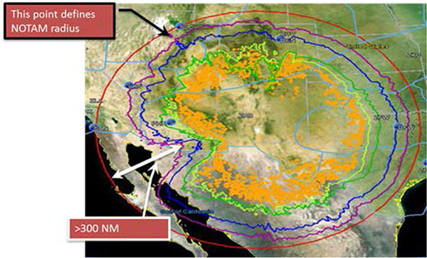
    Interference Contours from the YPG 17-02 GPS interference event in January 2017. (Source: FAA)
    Interference Contours from the YPG 17-02 GPS interference event in January 2017. (Source: FAA)

    An RTCA Tactical Operations Committee composed of Federal Aviation Administration (FAA) and industry experts in March issued a report with recommendations to change the current Notices to Airmen (NOTAMs).

    Along with a description of the event, NOTAMs show contours that represent an area outside of which operators should expect no interference impact. Both operators and the FAA agree that most aircraft experience no interference impact even inside the contours.

    Operators recommend that the FAA provide pilots and controllers improved understanding of where to expect interference impacts based on different equipment capabilities, so that operators could integrate such information in their flight planning processes.

    Impact varies widely, depending on aircraft, avionics, position, time, location and terrain. Effects could include complete loss of GPS navigation, position errors, loss of ADS-B or impact to GPS-dependent systems.

    Operators are encouraging thte FAA to conduct outreach with civil aviation stakeholders around significant interference events so they better understand the impact.

    The FAA says it is studying the committee’s 25 recommendations.

  • EOMAP launches online shallow-water bathymetry store

    EOMAP has released a commercial online store for global shallow-water bathymetry derived from satellite data. The store, EOStore Bathymetry, provides access to search for and request high-quality data.

    According to EOMAP, satellite-derived bathymetry (SDB) is now established as a valuable tool for the surveying, planning and management of coastal and offshore sites. SDB can provide shallow-water bathymetric data worldwide without the need for a physical presence in the area of interest.

    “The EOStore Bathymetry allows every coastal engineer, modeller or surveyor to rapidly access up-to-date shallow water bathymetric data,” said Knut Hartmann, COO of EOMAP. “It enables you to get the bathymetry data you need — even data you could otherwise not get — so you can plan and execute projects accurately, effectively lowering the project risk level.”

    EOMAP developed the bathymetry store in response to industry feedback, the company said.

    “The demand for bathymetry data in shallow waters is increasing significantly,” Hartmann said. “What industry told us at our first conference on satellite-derived bathymetry, in June 2018, was that they needed to understand the global feasibility of SDB methods and ways to search for and request the data. Thus, we’ve created the EOStore Bathymetry, which allows users to get worldwide shallow-water bathymetry data quickly and easily at a fraction of the price of traditional surveys.”

    According to EOMAP, EOStore Bathymetry offers different horizontal spatial resolutions of the bathymetric grid of 2 to 15 meters. This makes it flexible and fit for purpose for surveying, as well as for but also for planning and modeling purposes, the company added.

  • StarLink Tracker with Wi-Fi and GNSS enables connected cars

    StarLink Tracker with Wi-Fi and GNSS enables connected cars

    Photo: ERM Advanced Telematics
    Photo: ERM Advanced Telematics

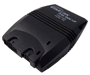
    Automotive technology provider ERM Advanced Telematics has launched the StarLink Tracker with Wi-Fi, which integrates advanced vehicle tracking, driver behavior monitoring, theft prevention, Bluetooth, Wi-Fi and 4G cellular capabilities in a single device.

    The company’s products have been installed in more than 1.5 million vehicles worldwide, the company said.

    The StarLink Tracker with Wi-Fi is the first product under ERM’s new Wireless Connect strategy, which aims to use wireless technologies to provide its partners — vehicle fleet management companies, vehicle manufacturers and importers and car insurance companies — with a competitive edge.

    The StarLink Tracker is a modular solution that is designed for installation both in vehicles on the production line and in the aftermarket, for vehicles that have left the production line. It turns any vehicle in which it is installed into a connected car.

    The modularity of the product allows the addition of capabilities anytime through the use of add-on products provided by ERM or by a third party. This can be done on demand and without any need to replace the StarLink Tracker device, which keeps functioning as the central tracking and communications unit under any such solution.

    The StarLink Tracker with Wi-Fi took about a year to develop, and ERM has already received its first orders to supply the product from customers in the United States, India and Australia.

    The 120-gram tracker creates Wi-Fi hotspots in the vehicle for up to eight devices. It features a GPS/GLONASS/Galileo location module and an ability to navigate inside underground parking lots or in mines; a 4G cellular modem; internal antennas, emergency button support and built-in data logger.

    Other capabilities are internal management of up to 500 driver IDs, remote immobilization, wireless connectivity to a wide range of additional ERM and third-party products and many other features.

    As the core infrastructure for a Connected Car applications, the product can integrate to full range of the vehicle’s internet connectivity needs, which are provided by the use of the tracking unit’s SIM card without the need for any additional SIM card, the company said.

    The StarLink Tracker with Wi-Fi and products that ERM Advanced Telematics will launch in the future under its Wireless Connect strategy, can be installed using the installer’s standard smartphone which communicates through Bluetooth connection in order to configure the product and perform any required adaptations. All this can be much faster compared to many other telematics devices and with much less hassle that might have arised due to the need to hook-up and hide wires.

    The StarLink Tracker with Wi-Fi is also equipped with a microphone and loudspeaker to initiate and receive calls and dial emergency numbers. One application for this can be E-Call (Emergency Call), such as in the European Union or just as an Emergency Call application.

    When pressing the location unit’s emergency button or immediately after an impact above a certain intensity, the unit will allows conversation between the vehicle’s occupants and the emergency center personnel, who can hear what is happening in the vehicle and identify events such as threats against the driver or accidents.

    The product will also provide information about the driver’s behavior, including careless driving, accidents, off-road driving, acceleration during turns, speed violations and more, information that can be used by the manager to significantly improve fleet management capabilities, performance and can decrease operational expenses.

  • The current state of the Defense, Security and Government PNT sector

    The current state of the Defense, Security and Government PNT sector

    GPS World magazine recently conducted the 2018 State of the Industry survey, an online polling of the GNSS community. It has become an annual feature, probing for the technical and business challenges that are drawing attention this year, how executives, managers and product developers are driving business in today’s economy, what issues they are concerned about, and — always — what solutions hold the most promise for positioning, navigation and timing (PNT) in challenged and indoor environments, regardless of which technology provides them?

    This column reports on the answers provided by those who identified themselves as working in the Defense, Security and Government (DSG) sector of the GNSS/PNT industry, and speculates on the insights that can be drawn from the answers.

    Among all who took the survey, 18 percent said they worked in Defense, Security and Government, the second largest group among eight industry sectors, following only Survey and High Precision in size. Of the DSG group members, 82 percent were based in the United States, 6 percent each in Europe and Asia-other-than-Russia-China-and-Japan, and 4 percent from Latin America. Slightly more than half of them worked in companies of more than 500 people.

    Queried as to job title, they answered as follows:

    Owner/president/co-owner/CEO: 8 percent

    Vice president, CTO, COO, CFO or similar: 6 percent

    General Manager: 2 percent

    Product or program manager: 10 percent

    Researcher: 12 percent

    Engineer: 44 percent, the largest group

    and Other: 18percent, with this last category encompassing consultants, cartographers, a security architect systems engineer, and more.

    Each sector group taking the survey answered two questions specific to their sector, while also responding to a variety of economic and systemic questions for the industry as a whole. In the DSG group, the specific questions were:

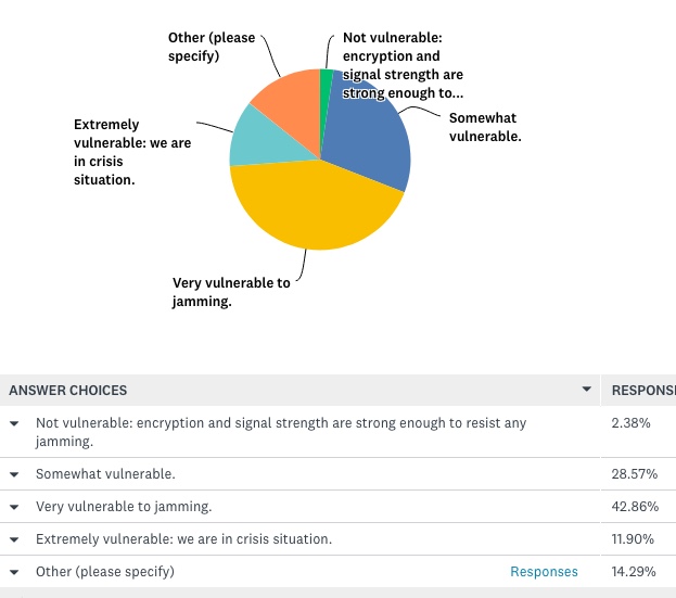
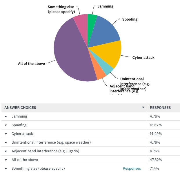
    How vulnerable is GPS/GNSS in defense/security/critical government applications, that is, M-code or similar, to disruption by jamming, whether intentional or unintentional?

    And:

    What is the greatest threat to GNSS over the next three years?

    The answers to vulnerability appear here:

    Source: <em>GPS World</em> 2018 State of the Industry survey
    Source: GPS World 2018 State of the Industry survey


    And the answers to threat here:

    Source: <em>GPS World</em> 2018 State of the Industry survey
    Source: GPS World 2018 State of the Industry survey

    Perhaps we erred in offering an “All of the above” answer, as nearly half of respondents selcted that option. This shows a generalized awareness (and fear) of threats, but lacks the capability to then prioritize those threats.


    Delving a little further into the responses from the DSG sector, when asked “What technology will win fully enable seamless outdoor/indoor navigation, in combination with GNSS,” they answered:

    Assisted GNSS           8.57 percent

    Assisted GNSS plus any ONE of the six other answers (Cell-tower triangulation, Proximity beacons, Radio frequency pattern-matching, Sensor-based dead reckoning, Terrestrial ranging system,Wi-Fi   22.86 percent

    And the winner: Assisted GNSS plus MORE THAN ONE of the six alternatives  34.29 percent

    With Don’t Know, 17.14 percent, and Other, 8.57 percent.

    More than any other solution an integration of at least three sensors, in the opinion of the plurality, will be necessary for ubiquitous positioning and navigation.

    First choice for a GNSS back-up? The leading answer was eLoran, at 25.71 percent, followed by Low-Earth orbit satellite constellations, 22.86 percent, and Sensor-based dead reckoning, 17.14 percent.

    How much effort are you devoting to mitigation of GNSS jamming and/or spoofing?

    This is the leading concern of out research and development effort   40 percent

    This is an important concern for our R&D, but not the dominant one          20 percent

    This is one among many factors we consider; no particular importance above others 17.14 percent

    And very surprisingly: We are not focusing on jamming/spoofing mitigation at all at this time        22.86 percent

    Finally, describe the market for GNSS products/services in the Defense, Security and Government PNT industry sector as of today.

    Very healthy; strong growth   25.71 percent

    Relatively healthy; moderate growth  48.57 percent

    Flat      22.86 percent

    Slightly down  2.86 percent


    For more results from the 2018 State of the GNSS Industry, see this page.

  • Geneq introduces Net20 Pro GNSS CORS reference receiver

    Geneq introduces Net20 Pro GNSS CORS reference receiver

    Net20 Pro. (Photo: Geneq)
    Net20 Pro. (Photo: Geneq)

    Geneq Inc. has introduced the Net20 Pro, a robust system designed for Continuously Operating Reference Station networks.

    The Net20 Pro’s efficiency and flexibility will provide high-quality data for users interested in the proximity and reliability of a reference station while eliminating real-time kinematic (RTK) corrections service charges, the company said.

    The Net20 Pro uses multi-frequency, 555-channel technologies in a rugged casing to deliver accurate and effective positioning data even in a harsh environment.

    The receiver can be configured for correction data reception in client mode to calculate a fixed RTK position and to monitor the antenna position while continuing to work as a GNSS reference server.

    With its NTRIP Caster software, the Net20 Pro provides superior connectivity with an unlimited number of mount points, Geneq said. Users can have permanent transmission of RTK corrections with a simple local internet connection from a LAN working network.

    Equipped with an internal memory of 32 GB with an additional 32 GB external memory, the Net20 Pro provides enough storage space for permanent recording even for a 100-Hz high data sampling rate.

    The Net20 Pro comes with an ergonomic and easy-to-manage web user interface that features software upgrade, status and settings management, as well as data downloading via smartphone, tablet or other internet-enabled electronic devices.

  • CHC Navigation acquires AMW for machine control

    CHC Navigation has acquired the business assets and personnel of AMW Machine Control Inc. The business will now be conducted by AMW Machine Control Solutions Inc. as a subsidiary of CHC Navigation.

    AMW Machine Control Solutions has more than 30 years of advanced machine guidance, machine control and GNSS experience. Its topographic and machine-control software solutions include grade, dirt, ditch, pipe, landfill and road. AMW Machine Control Solutions offers cost-effective solutions designed for equipment operators, the company said.

    The offerings of AMW Machine Control Solutions will be based on turnkey, wireless CHC Navigation Android industrial tablets and CHC Navigation’s RTK GNSS receivers.

    AMW Machine Control Solutions has appointed Phil Gabriel as president. Gabriel has more than 25 years of experience in the positioning industry. He previously served as president of Hemisphere GNSS Inc. and is currently serving as the general manager for CHC Navigation North America.

    With these changes, CHC Navigation said it is poised to significantly grow its global market share in the agriculture civil engineering and construction industry, with products catering to small, medium and large enterprise farming and construction equipment users.

    “Our customers really like CHC Navigation’s positioning products and their new Android tablets,” said Mark Williams, founder of AMW and now director of product management. “We have redeveloped our popular applications from the ground up to run Android while being more intuitive and wireless, wherever possible. With standardized hardware, AMW Machine Control Solutions will be able to better support our existing customers and to attract new ones.”

    “AMW has been innovating in-machine control for many years. We are pleased to combine forces to offer the market incredible value and simple to use products,” Gabriel said.

  • Trimble RTX achieves greater than 2-cm horizontal accuracy, company says

    Trimble RTX achieves greater than 2-cm horizontal accuracy, company says

    The Trimble RTX GNSS corrections technology can now achieve horizontal accuracies of better than two centimeters, according to Trimble.

    Start-up times, commonly referred to as convergence, have also improved.

    (Photo: Trimble)
    (Photo: Trimble)

    Users can now achieve full accuracy in less than 15 minutes, and as fast as one minute in select areas where RTX Fast network infrastructure is available, the company added.

    This performance is achievable using Trimble’s premier correction service, CenterPoint RTX, delivering RTK-level accuracy outside traditional Virtual Reference Station (VRS) networks, considered the gold standard for high-accuracy corrections.

    Trimble’s RTX network is available throughout most of the world, with the RTX-Fast network coverage available in select geographies in the U.S., Canada and throughout most of Europe when using Trimble RTX compatible GNSS receivers.

    Trimble RTX provides a satellite-delivered correction source. In addition, corrections are available via an Internet or cellular connection, adding to its versatility.

    With satellite-delivered Trimble RTX corrections, users can perform a variety of positioning fieldwork in some of the most remote locations, without relying on traditional ground-based VRS networks or a local RTK base station to receive high-accuracy positioning data.

    By powering on an RTX-capable receiver or display, customers can start working quickly with only a minimal convergence period, Trimble said. As long as users have line of sight to the sky they can work freely without being constrained by the geographic boundaries of a VRS network.

    Offering a suite of correction services, Trimble RTX provides users the flexibility to choose the level of accuracy to suit their application needs from meter to centimeter level. It is designed for a variety of applications including agriculture, survey, mapping, construction, automotive and any location-based service that could benefit from greater precision.

    Trimble RTX also powers Trimble xFill technology, a feature that enables RTK and VRS users to continue working if their primary correction stream is not available. xFill, delivered via satellite, “fills in” for RTK corrections in the event of temporary radio or Internet connection outages. As a result, users can experience fewer interruptions and less downtime.

    “Trimble RTX performance and reliability are changing the positioning game for users who never considered a satellite-delivered correction service for applications traditionally requiring RTK-level accuracy,” said Patricia Boothe, vice president of Trimble’s Advanced Positioning Division. “Trimble RTX offers a global solution delivering similar performance to VRS where terrestrial networks are not available.”

    Subscriptions are available through Trimble’s Authorized Business Partners or Trimble’s online store.

  • PCTEL announces Trooper II antenna for public safety

    PCTEL announces Trooper II antenna for public safety

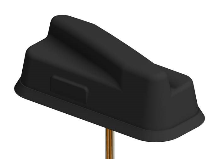
    PCTEL Inc. has announced the next generation of its Trooper antenna, the company’s flagship multi-band platform for public safety fleets.

    The new Trooper II provides optimal wireless communications performance through the antenna’s 4-port 4G LTE connections and 4×4 802.11ac Wi-Fi MIMO capability, the company said. It also incorporates PCTEL’s newest high rejection multi-GNSS technology for high precision tracking and asset management.

    The Trooper II antenna. (Photo: PCTEL)
    The Trooper II antenna. (Photo: PCTEL)

    “The Trooper II antenna enhances PCTEL’s successful Trooper platform, with expanded multi-band RF and GNSS capability in a robust, aerodynamic housing,” said Rishi Bharadwaj, senior vice president and general manager of PCTEL’s Connected Solutions group. “Its slender new design with a single cable exit accommodates installation restrictions often encountered on modern public safety vehicles.”

    “Our Trooper antennas have been broadly deployed on public safety fleets, notably in support of  the leading FirstNet public safety broadband network systems. The Trooper II is also ideal for many Industrial IoT deployments,” Bharadwaj added.

    The rugged Trooper II (part #GL9X1AX-TRB) features PCTEL’s new proprietary high rejection multi-band technology, which supports GPS L1, GLONASS and Galileo for high precision tracking.

    In addition to public safety applications, the antenna is suitable for tracking and communications support for industrial internet of things (IoT) and other fleet management applications, including farming tractors for precision agriculture, utility service fleets and railway positive train control systems.

    PCTEL will display the Trooper II antenna Aug. 6-7 at APCO 2018, Booth 1719, along with its portfolio of antennas for the public safety industry and grid testing solution for in-building public safety networks.

    The Trooper II antenna is available for pre-order now. First shipments are expected in early fall.

  • Venezuelan assassination attempt highlights need for UAV security

    Two drones armed with explosives detonated near Venezuelan President Nicolas Maduro on Aug. 4 in an apparent assassination attempt that took place while he was delivering a speech to hundreds of soldiers, while the speech was being broadcast live on television, according to press reports.

    The footage of this apparent assassination attempt can be viewed below.

    Drone security solutions company DroneShield issued a statement about the incident. 

    “The history of commercial drone incidents involving heads of state goes back to September 2013 when the German Chancellor Angela Merkel’s public appearance was disrupted by a drone, which was apparently a publicity stunt by a competing political party,” said Oleg Vornik, DroneShield’s CEO.

    “Yesterday’s apparent drone assassination attempt on Venezuelan President Maduro is the first known drone attack on a head of state. An attempted drone assassination of a sitting sovereign leader demonstrates that, sadly, the era of drone terrorism has well and truly arrived,” Vornik said.

    “Technological progress cannot be reversed, and going forward, the security of any asset whose perimeter is protected two-dimensionally on the ground will need to be also protected in the third dimension — from attacks from the air,” Vornik added.

    DroneShield supplies counterdrone (counter unmanned aerial system/counter unmanned aerial vehicle/c-UAS) products, which have been successfully deployed in a variety of situations by third parties.

    The company’s products have been deployed for counterdrone security at, among others:

    • an ASEAN meeting of heads of state,
    • several Boston Marathon events over the years,
    • the PyeongChang 2018 Olympics and
    • the 2018 XXI Commonwealth Games.

    Also, a Middle Eastern ministry of defense recently placed a multi-million dollar order for DroneShield’s anti-drone equipment.

    The company expect that this latest incident involving a head of state will result in governments around the world accelerating their implementation of anti-drone mitigation measures.