Hexagon, a global provider of information technology solutions, has launched HxGN AgrOn Production, an integrated cultivation management solution that empowers customers to optimize resource efficiency, increase yield, reduce inputs and ensure quality.
The solution is comprised of software and hardware solutions that optimize and automate entire crop cycles from planning to cultivation.
Hexagon officially revealed HxGN AgrOn Production today at Agrishow, one of the world’s largest agricultural technology fairs in the world taking place in Ribeirão Preto, Brazil.
“Real-time information is the key to efficient field management. HxGN AgrOn Production brings immediate benefits to agricultural and forestry companies — providing instant control of all stages of the cultivation process and enabling resource optimisation and efficiency,” said Ola Rollén, president and CEO of Hexagon.
According to the company, the solution will enable Hexagon’s customers to achieve a smarter cultivation by connecting, synchronizing and optimizing workflows, teams and information while reducing operating costs.
HxGN AgrOn Production addresses resource management challenges of enterprise farms and is a future-proof investment in information technology innovations that are enabling the smart digital reality in agriculture.
For several months, Talen-X engineers have been working with the proper channels to develop MNSA (Modernized Navstar Security Algorithm). Talen-X is designing the implementation of MNSA for its flagship products: BroadSim and BroadSim Anechoic.
BroadSim is a software-defined GNSS simulator made to accomodate engineers who test systems requiring encrypted signals, jamming and spoofing. According to the company, BroadSim Anechoic leverages the same software-defined capabilities, scaled to enable powerful anechoic chamber simulations.
Encrypted signal simulation is being used to support many military testing applications, both in the lab and in the field. BroadSim can simulate many signals including the legacy GPS Y-Code and the modernized GPS Advanced Encryption Standard (AES) M-Code, the company said.
Other companies use costly and outdated field programmable gate arrays (FPGAs) to upgrade their systems. With Talen-X, users can opt for a simple license upgrade to enable the new GNSS signals to include GPS AES M-Code and eventually MNSA on their BroadSim device.
With the addition of MNSA, engineers testing capabilities will reach the closest they’ve ever been to simulating real-world scenarios, ensuring complete confidence in the accuracy and resiliency of the test unit.
The U.S. Army has awarded to Orolia subsidiary McMurdo a $33,986,800 contract to manufacture Personnel Recovery Devices (PRD) for warfighters. The contract is for indefinite-delivery/indefinite-quantity, with an estimated completion date of March 6, 2022.
The PRD is a dual-mode, MIL-SPEC locator beacon that will be integrated into the Army’s Personnel Recovery Support System (PRSS). It will be capable of transmitting both open and secure signals to alert and notify that a soldier has become isolated, missing, detained or captured.
The positioning device will optimize a successful rescue operation for soldiers in a distress situation through secure enhanced capabilities. It has been designed to meet military standards and specifications, and has improved accuracy, decreased size, weight and power (SWaP) requirements.
“We are extremely proud and honored to have been selected by the US Army as the provider of this critical positioning device for the safety of U.S. warfighters,” said Jean-Yves Courtois, CEO of Orolia. “Easy to incorporate into Personnel Recovery operations, the PRD is based on Orolia’s new rugged and small PNT platform dedicated to dismounted soldier Assured PNT applications.”
“This award, which follows the 2016 contract from the U.S. Coast Guard to produce 16,000 FastFind 220 personal locator beacons, is a testimony to Orolia’s world leadership in Resilient Positioning, Navigation and Timing,” he said.
The Personnel Recovery Support System Personnel Recovery Device contract was awarded by the U.S. Army Contracting Command, Aberdeen Proving Ground, Maryland, on behalf of the Army Air Warrior Product Management Office at Redstone Arsenal in Huntsville, Alabama.
This month, we bring you a guest column on the 34th Space Symposium in Colorado Springs, Colorado. Robin Wrinn, a communications professional based in Atlanta, gives her perspective on the premier annual space event, held in April. Among her findings: information on the mission longevity vs. technology innovation debate, GPS IIIF program bids, discussions of time and space, and more.
— Alan Cameron, editor
During recent interviews with Lockheed Martin and Harris Corporation conducted during the 34th Space Symposium (April 16-19) in Colorado Springs, time and space were a frequent focus of discussion, but not in the normal “continuum” kind of way.
Greater mission longevity is one of the key improvements GPS III delivers over those currently in service. Space Vehicles 1-10 have a planned mission life of about 15 years – 25 percent longer than their satellite predecessors. Yet that bragging right begs the question “How long should a satellite ‘live’ up in space with technology innovation occurring almost annually?” After all the last Block IIR-M series satellite was launched in 2009. To put that into perspective, that same year the Canadian company Blackberry (RIM) held 20 percent of the smartphone OS market share and was the second largest OS in the world. Apple had just introduced the iPhone two years earlier.
A partial answer to that question it seems is advanced payload technology. Both Lockheed Martin and Harris Corporation highlighted their advances in payload capabilities that would enable built-in flexibility to adapt satellites in orbit to advances in technology, as well as changes in missions. Lockheed Martin provided the media a tour of their RF (Radio Frequency) Payload Center of Excellence (Payload Center). Meanwhile, Harris Corporation recently announced that is has completed development of the company’s fully digital Mission Data Unit (MDU), which is core to the navigation payload for GPS III 11 +.)
As a reminder, the current Harris payload for SVs 1-10 includes:
Greater than three times reduction in range error,
Up to eight times increase in anti-jamming power,
Added signals – including one (L1C civil signal) compatible with other Global Navigation Satellite Systems (GNSS), like the European Space Agency’s Galileo.
And greater signal integrity.
According to Harris, the new, fully digital navigation payload it has engineered will deliver more powerful signals, PLUS the ability to change and upgrade the satellites incrementally over the mission life.
Meanwhile, Lockheed recently announced a partnership with NEC to introduce artificial intelligence for computer learning in orbit. And the company’s Payload Center subject matter experts touted their significant advances in processers and a move toward the next generation of antennas, arrays and transmitters that would drive more flexibility and capability and resilience into satellites.
Observation: It seems the market pressures of ‘new space’ players is prompting delivery of products that can drive more value for less cost. In this case, delivery of a common payload architecture and electronically steered beams to make satellite antennas become any shape you want. Most likely, beams of a different size on demand is a much better business case than a static one built five years ago.
GPS III 1-10 on track. in full production. GPSIII SV1 awaiting U.S. Air Force “Call Up” for Launch
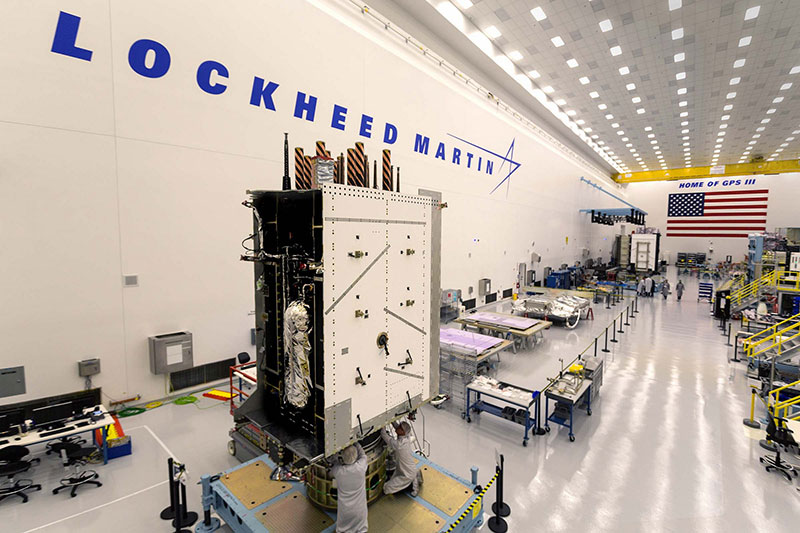
Lockheed Martin’s GPS III SV03 became fully integrated in August 2017. Photo: Lockheed Martin
The day I interviewed Lockheed Martin’s Navigation Systems mission area Program Manager Johnathon Caldwell, the company had submitted its proposal for the U.S. Air Force’s GPS III Follow On (GPS IIIF) program. That same day, April 16, the media was given a tour of Lockheed Martin’s GPS III satellite assembly floor. It was clear from both Lockheed’s press materials and Caldwell that Lockheed Martin believes it is fully recovered from prior production hiccups and is
• “on track” to deliver GPS Space Vehicles (SVs) 1 through 10, and
• deserves to win the bid for GPS IIIF. Now that Boeing has dropped out of the running, it seems they probably have it. (The government has said it will announce the award in March 2019.)
Here is the GPS III SVs 1-10 Update:
SV 01. Declared “Available for Launch” (AFL) by the Air Force on Sept. 28, 2017. Awaiting “Call Up” for launch. A formal date has not been set. “Sometime this year” was the answer Lockheed Martin provided when asked a timeframe.
SV 02. Completed Thermal Vacuum (TVAC) testing, Dec. 2017. Currently in final environmental EMI (electromagnetic)/EMC (electromagnetic compatibility)/PIM (passive intermodulation) testing. AFL expected Summer 2018.
SV 03. Fully integrated, Fall 2017. Currently in TVAC testing, AFL expected. Spring 2019
Interview with Harris Corporation’s Jason Hendrix, PNT Program Director.
GPS World readers are familiar with the differences in the GPS III signals as compared to those transmitted by satellites to date. What are the differences in the GPS III satellite payloads that were instituted to enable those new signals?
The main difference is the power. The Air Force’s requirements called for significantly more anti-jamming capability. All the transmitters are a higher power.
What was the most significant obstacle (or top obstacles, plural) in designing and manufacturing this new payload, to new Air Force specifications? How did you overcome it/them?
Same answer really, the higher power. Keeping in mind, we went from a 7-year mission life requirement to a 15 year. That higher power puts more strain on components and new cyber requirements in software. When you couple all that together we are not just upgrading payload technology. It is really engineering a new set of payload requirements. It’s new generation, advanced.
What are the advantages of a digital payload over the alternative? When you say “Our current GPS payload is 70 percent digital” does that refer to the IIR payload? The offered “fully digital navigation payload with enhanced performance” — is that the GPS III payload? What’s the new 30 percent that has gone digital?
The advantages and the 30 percent difference are the timekeeping system portion. We’re moving from a manual, analog timing to digital to deliver to the Air Force more flexibility. It’s a nice option to have to be able to reprogram in orbit and maybe enhance capabilities desired in the future.
Can you provide any perspectives on how Harris is performing now in delivering payloads for SVs 1-10?
We’re now ahead of schedule. We delivered the 5th payload three weeks early (early March 2018). We are on time for 4 and three more are due this year.
Interview with Lockheed Martin’s Navigation Systems Mission Area Program Manager Johnathon Caldwell
Can you provide some general updates on assembly of GPS 1-10?
Photo: LMCO
Vehicle SV01: It is ready and we’re very excited about that. We defer to the Air Force on questions about launch date. But once they call it up we will install the solar panels and take it to a C-17. Then load it in the back of the plane and fly it down to Florida. We will then take it over to the vehicle processing facility and mate it up with the launch vehicle provider. The GNST – the satellite prototype -has gone to the Cape twice already. So, we have conducted a dry run for shipping SV 01.
Vehicle SV02: It has completed thermal vacuum testing – a major milestone. We’re in the last of the environmental tests. And we’re tracking to have that vehicle declared AFL this summer.
Vehicle SV03. It is fully integrated and is in the T-Vac chamber now. The door is closed and it’s going through tests. (Pump down to vacuum is achieved in approximately three hours and the total testing time is 70 days.)
Vehicle SV04: It is fully integrated on the floor. It is in its baseline electrical tests and will be in environmental tests as soon as 3 comes out of the chambers. It is staged to go in right after – 3.
Vehicle SV05: It is about to go through its integration to the propulsion core. And five has its navigation payload. Integrating it this summer.
Any changes in your production approach having completed SV01 that you are fixing in your production approach to SV02, 03 or 04?
No, the performance on Vehicle 01 was as designed there were no technical or design changes necessitated throughout the rest of the fleet. So, it was a very successful from that perspective – from the standpoint of validating the design and wringing it out, Vehicle 01 served its purpose well.
It had a very good T-Vac. I would say overall when you look at the industry, Vehicles 01 – 02, our vacuum test campaigns are the most rigorous test. Both went through their tests quite well. Some of the best I’ve seen.
We consider thermal vacuum the gold standard for testing any satellite before it goes into operations. It really is putting the craft through the paces. When it goes through the testing, the satellite is on. It is working. It is exposing it to the heat and the cold and the zero pressure while the satellite is functional. The entire thermal vac testing from start to end is a little over 70 days. “Test like you fly.” From the time it launches and deployment sequence we test it like it is real. Minus the shaking, the satellite thinks it is getting launched. Meanwhile, our people are looking at the data and its health. T Vac is a huge milestone for a satellite to go through it and come out without any issues. Which is why we are so pleased about the two.
Have there been any production delays since last year.
No, we’ve been quite stable in our production schedule.
Can you shed some light as to how many Lockheed Martin employees are involved in the production of GPS III?
The way we’re organized, there are engineers that flux in and out of the project depending the stage we’re in. This is production program, so we use the skillsets we need at the time we need them, then those engineers go on to do other work. But this also comes back to some of the commonality we’re trying to achieve across out product lines. That when you have common processes, common parts and common procedures in building spacecraft you gain leverage and major cost savings to have flex in resources.
Can you speak to any issues with subcontractors? Any delays?
No, since last year, the Harris production line has stabilized. We’ve been receiving Harris payloads, and we’ve just received the 5th payload and we’re finishing up integration. Vehicle 6 navigation payload is currently in test. And Vehicle 7 and 8 payload production is going according to schedule. We feel Harris has definitely overcome some of the challenges of the past. And we’ve been seeing stable production deliveries. By the end of this year we should receive 3 more payloads and by the first quarter of next year, the 8th, and they are contracted for 9 and 10.
From a civilian perspective, can you remind us what will be different with GPS III?
Three times better accuracy and up to eight times improved anti-jamming capabilities. And it is a longer life vehicle and healthy constellation of satellites that people can rely on. The new L1C signal is common with other GNSS, like Galileo, so as that becomes incorporated into equipment, it will give you more data points for better service, more accuracy and reliability.
For GPS IIIF requirements, are there capabilities that will require innovation or new technology?
We’ve designed with some of those capabilities in mind. If you just look down the list. The regional military protection is about bringing higher power and boosting the signal where the military needs it most. That’s not a particularly new technology per se, but it is bringing a new capability that the current GPS satellites don’t have.
The Search and Rescue payload, again, I wouldn’t consider it a new capability, it is provided by a partner nation, a Canadian company, but it effects those folks in need.
Digital payload. For 11+, fully digital payload for greater flexibility for the government. It allows the government to expand or enhance capabilities of the mission over time. It enables loading new software to do different things.
GPS III was designed with a modular, flexible architecture. Because Lockheed Martin knew that as time goes by, technology evolves. New technology becomes available and the government’s mission needs are likely to change.
Now that ability to evolve is down to the payload with a fully, 100 percent digital payload.
Lockheed Martin has been working on a lot of the GPSIII F design requirements already (preliminary design review level).
Can you speak to the other “Risk Retired” you mentioned in your slides?
Last fall, we had our first time with the OCX zero ground system. It’s one thing to talk to satellite in the high bay, it’s another thing to talk to it with the entire Air Force control network you plan to use when you’re operating. So, we were excited to get that done and run the entire chain from the vehicle out from the Air Force control network the AFCN network, utilizing the OCX system to command the vehicle. It was a big milestone for us. And previously we demonstrated our compatibility of our signals (with OCX).
Our future satellites in our GPS IIIF proposal share a common design with GPS III so they also will be compatible with OCX because we have proven that compatibility.
Can you speak to the GPS III Ground System Support Contracts Lockheed Martin has received?
The government asked us to help provide some gap fillers for the ground system (rmw note: if OCX isn’t there yet). To take the heritage AEP ground system and provide the ability to fly GPS III satellites using that ground system. So that activity has been going well and the critical design review has been completed and it is on track for delivery to the government next year. And subsequently, we were also put on contract for the M-code new signal to add some capabilities to the legacy ground system to begin to furnish early use of that new GPS III M-code signal to the military. We’ve been working hard on that. We conducted our preliminary design review last fall and just recently completed a critical design review to add that capability.
Hemisphere GNSS has launched a new UT series of GNSS-capable rugged handheld devices to support industries such as construction, survey, GIS, mapping, asset/logistics management, public safety, utilities and military.
The UT handheld devices are designed to work in the harshest environments imaginable and offer impressive and powerful feature sets.
Hemisphere made the announcement at Intermat Paris 2018, where it is exhibiting at stand 6 J 027.
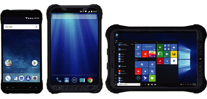
The UT10 6-inch rugged phone and UT30 8-inch rugged tablet both feature Android 8.0 operating systems with Qualcomm octa-core 2.2 GHz processors, 4 GB of RAM, and 32 GB onboard storage.
The UT50 10.1-inch full-rugged tablet features the Windows 10 operating system with an Intel Core Skylake i5 processor up to 2.8 GHz, 8 GB RAM, and 128 GB of onboard storage.
According to the company, all three new UT models provide the latest high-resolution, capacitive touchscreen and direct sunlight-readable display technology for ease of visibility in all situations. The UT50 also has a 10-finger multi-touchscreen and supports wet hands and gloves operation.
The devices have dual built-in cameras. The UT10 and UT30 handhelds feature 13 MP rear and 5 MP front cameras.
The devices are designed to be drop-resistant from heights of 1.2 meters (1.5 meters for the UT10), are rated at IP67 (IP68 for UT50), and are certified to both MIL-STD-810G and MIL-STD-461F military standards to ensure durability in most outdoor or challenging environments.
The UT10 and UT30 are powered by single 8,000m Ah and 8,200 mAh batteries with Qualcomm Quick Charge 3.0 technology, while the UT50 offers dual hot-swappable batteries at 2,900 mAh each so users can continue working in the field without powering down.
“With varying specifications and options between these devices, mobile workers are sure to find them suitable to fit their demanding work environments,” said Miles Ware, director of marketing with Hemisphere GNSS. “These powerful machines reflect the latest in hardware standards and are exceptional complimentary additions to our product portfolio.”
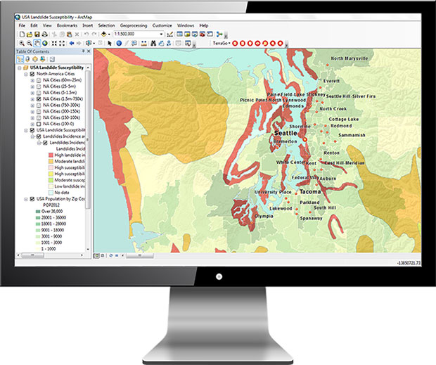
TerraGo has released TerraGo Publisher for ArcGIS version 7.4, which includes the ability to create and share GeoPDFs that convey important changes over time for an area of interest, with any type of map or imagery. The time-enabled visualization can animate geographic changes over time with interactive maps that can be shared with anyone using free Adobe Reader, the company said.
“Our customers can share these time-series map layers as a universally available GeoPDF, enabling non-GIS users to measure past conditions, assess changes over time, analyze trends and even project future scenarios,” said Scott Lee, director of federal programs at TerraGo. “Time-enabled GeoPDFs can help deliver important geographic analysis to the widest audience possible, which is incredibly valuable for sharing information with policy makers, agencies, stakeholders and constituents.”
Time-enabled, interactive maps can be used in any number of different geographic analysis use cases. Here are a few examples.
coastal populations impacted by rising sea levels
progress of recovery efforts for a hurricane disaster zone
forestry and environmental impacts due to policy change
shifting crime patterns in different types of city zones
satellite imagery showing impact of regional military conflicts on local populations
Version 7.4 includes additional enhancements and improvements including support for ArcGIS version 10.6.0.
TerraGo will also be showcasing the latest features at GEOINT 2018, the United States Geospatial Intelligence Foundation Symposium, which takes place April 22-25 in Tampa, Florida.
Hemisphere GNSS has made significant achievements with its GradeMetrix OEM toolkit for high-precision GNSS-based machine control and guidance applications and systems.
Hemisphere has expanded its portfolio of hardware offerings, including the A222 Scalable GNSS Smart Antenna introduced in November 2017, and made significant strides forward with its next-generation GradeMetrix OEM application software platform.
Whether it is grading, mining, excavating, drilling and piling, or compaction applications, heavy equipment manufacturers can rebrand the solution and drive feature requirements to sell as their own.
Hemisphere made the announcement at Intermat Paris 2018, where the company is exhibiting at stand 6 J 027.
The GradeMetrix toolkit allows OEMs to select components, a-la-carte or as complete solutions, based on their accuracy and durability requirements and integrate into their machines to design their own IP. This allows manufacturers to maintain a competitive advantage in the marketplace, as they do not have to compete with conventional or traditional machine control and guidance dealers selling aftermarket systems, the company said.
Hemisphere owns the design of the toolkit and its components and ensures each component is reliable with guaranteed compliance through design. The fully customizable and flexible toolkit provides the ability to tailor displays and outputs, per OEM requirements, and also offers OPA (open architecture) for implementing inputs and third-party sensors already available on machines.
Through UniStrong, Hemisphere’s parent company, the GradeMetrix toolkit also has seamless access to complimentary and innovative technologies. This allows for much faster times to market, driving increased revenue streams for OEMs, and provides a high cost/value ratio.
“The feedback we are receiving from OEMs already using our GradeMetrix toolkit is outstanding,” said Randy Noland, vice president of Global Sales & Business Development with Hemisphere GNSS. “For the first time in our industry, we are offering OEMs the opportunity to build their own machine control and guidance systems using their specifications and offering it to their customers, with their brand, 100% of the time.”
Manufacturers are looking for flexibility and price performance in existing system offerings or in new systems. Hemisphere continues to provide anfull system OEM positioning solution toolkit for building powerful, complete or a-la-carte machine control and guidance systems including GradeMetrix OEM application software and an array of compatible GNSS hardware components.
These include IronOne Rugged Display & Computer, A222 Scalable GNSS Smart Antenna, A326 Rugged GNSS Smart Antenna, Vector VR500 Rugged All-In-One Smart Antenna, Vector VR1000 Rugged GNSS Receiver, and C321+ RTK Base & Rover with SiteMetrix Site Management Software.
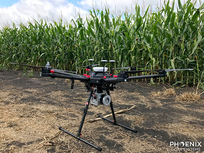
Phoenix Lidar’s Scout System features NovAtel SPAN GNSS/IMU equipment and a pinwheel antenna. Combined with Phoenix’s hardware and software, this lightweight UAV lidar system serves in agriculture, construction and other general mapping applications. Here the Scout is integrated with the DJI M600 Pro UAV. (Photo: Phoenix Lidar Systems)
As a UAV flies, it is subject to roll, pitch and yaw movements, adversely affecting the high-definition imagery that industrial-grade UAVs are designed to collect. Three measures combat unwanted movement: a stabilizing gimbal, a high-quality GPS/inertial measurement unit (IMU) integration, and orthorectification of the data during post-processing.
Imaging applications are driving all sectors of the booming UAV market. The increasing availability and variety of compact, robust, lightweight sensors, employing a range of super-resolution and often multi-spectral and hyperspectral technologies, continuously expand and improve UAV applications.
Three companies exhibiting at the Association for Unmanned Vehicle Systems International’s (AUVSI’s) massive Xponential show May 1-3 will showcase recent advances in this arena.
Challenges of Airborne Imaging. Size and weight govern UAV deployment.Imaging sensors must fit compact payload bays. An integrated UAV solution will typically include an imaging sensor, a high-performance GPS/inertial measurement unit (IMU), and a data storage hub to collate streams of data from all connected instruments.
Software geared specifically to flight supplies image orthorectification and manages sensor operation during the mission, enabling users to input GPS coordinates for sensor operation. Outside of defined coordinates, the sensor will not collect data, reducing the amount of data to store or transmit.
Immediate or real-time processing and georeferencing of imaging products has always been key to defense and security applications; it becomes critical for precision agriculture, cartography, civil engineering, remote monitoring and surveillance, intelligent inspection, disaster preparedness and risk study, newsgathering, cinematography, tourism and even commercial advertising. A multisensor landscape view can improve a UAV’s ability to react intelligently without operator input.
Integrated GPS/INS exhibitors at the Xponential show include:
NovAtel (Booth 3219). The company uses a flexible technology platform and diverse OEM products, which include SPAN technology: tightly coupled GNSS receivers with IMUs for reliable, continuously available, position, velocity and attitude, to deliver its vision of assured positioning — anywhere.
NovAtel offers TerraStar Correction Services to provide accurate real-time sub-meter or decimeter positioning around the world, anytime. Its Waypoint Inertial Explorer Xpress post-processing software provides the same core processing and utilities as Inertial Explorer along with simplified functions and workflows tailored for UAV markets and small project areas.
VectorNav (Booth 2214). Engineers at Octopus ISR integrated the VectorNav VN-200 GPS/INS directly into the optical bench of a gimbal to deliver positioning accuracy under flight conditions such as high vibrations, accelerations and temperature fluctuations. The device flies aboard the UAV Factory’s miniature Epsilon series of gyro-stabilized gimbals, enabling the Precision Geo-Lock feature, which combines a GPS-aided inertial navigation system with dedicated software algorithms and payload operator software.
The VN-200 features 16g accelerometers and 2000°/sec gyros in a postage-stamp-sized surface-mount device and a rugged package. Epsilon gyro-stabilized turrets are available with both VectorNav’s VN-200 single GPS-based INS solution and the VN-300 dual GPS-based INS.
SBG Systems (Booth 2535). The company developed specific calibration procedures to provide reliable heading even when UAVs tilt. Magnetometer calibration can be processed in 2D on the ground, or in 3D in flight. Qinertia software enhances inertial navigation systems performance by post processing inertial data with raw GNSS observables.
SBG Systems’ Ellipse 2 Micro high-performance inertial sensors reduces size and costs and for volume projects. It is available as an inertial measurement unit (IMU), or as an attitude and heading reference system (AHRS) or inertial navigation system (INS) running an extended Kalman filter, connected to an external GNSS receiver.
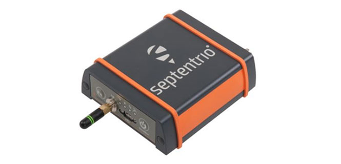
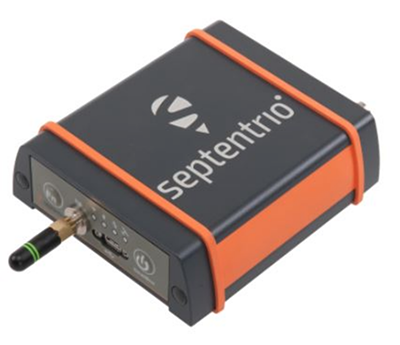
GNSS receiver manufacturer Septentrio is introducing its AsteRx SB at two industry shows: Expomin in Santiago, Chile (April 23-27), and Intermat in Paris, France.
According to the company, the AsteRx SB delivers Septentrio’s quad-constellation real-time kinematic (RTK) positioning in a low-power, IP68 compliant housing. Built around the AsteRx-m2 GNSS receiver engine, the AsteRx SB features Wi-Fi, Bluetooth, USB, Ethernet and serial connectivity.
Septentrio’s GNSS+ suite of positioning algorithms converts difficult environments into good positioning: LOCK+ technology to maintain tracking during heavy vibration, APME+ to combat multipath, and IONO+ technology to ensure position accuracy during periods of elevated ionospheric activity.
The AsteRx SB also features the AIM+ interference mitigation and monitoring system, which can suppress the widest variety of interferers, from simple continuous narrowband signals to the most complex wideband and pulsed jammers.
AIM+ interference monitoring and mitigation system
L-band PPP, RTK, scalable accuracy
High-update rate, low-latency positioning
Base and rover operation
Bluetooth, Wi-Fi, Ethernet, serial and USB communications
Whether exposed to the elements or inside a vehicle cab, operating alone or as a core component of a sensor-fusion system, the AsteRx SB is straight-forward to set up and integrate into any new or existing application. Using Wi-Fi or micro USB, the AsteRx SB can be configured and monitored using any device with a web browser.
“We believe the AsteRx SB is the best all-rounder on the market today. We’ve produced a small and low-power device with zero compromise on performance,” said Gustavo Lopez, product manager at Septentrio. “From machine control to sensor-fusion applications, manned or unmanned, the compact size and low power of the AsteRx SB along with its range of communications options make it ideal for any project requiring reliable high-precision positioning.”
At Intermat in Paris, Septentrio will exhibit at Booth 6H-041 and at Expomin in Santiago, Chile, at Booth 1K-30.
Boeing has decided to not submit a proposal to build up to 22 GPS III satellites for the U.S. Air Force. The GPS III Follow On (GPS IIIF) program will supply additional upgraded satellites to replace ones now in the constellation.
“We have not put in a proposal for GPS III,” said Rico Attanasio, Boeing’s director of Department of Defense and civil navigation and communications programs, to Space News.
Lockheed has been the only producer of GPS III satellites, and is now under contract to build the first 10. Boeing built earlier versions of GPS satellites.
In February, the U.S. Air Force Space Command (AFSC) released its request for proposals (RFP) to build the 22 GPS III satellites, called the GPS III Follow-On Phase 2 contract. The estimated dollar value of the acquisition is $10 billion including all options.
Phase 2 is planned as a single, predominantly fixed-price incentive-type contract awarded via full and open competition for production of 22 GPS III satellites. Deadline for proposals is April 16. Construction is to begin in fiscal year 2019 (Oct. 1, 2018), with delivery of the first satellite in 2026.
Boeing thought it could compete based on “innovation, resilience [and] a new payload, but that wasn’t emphasized,” Attanasio told Space News. “It wasn’t a good fit for us.”
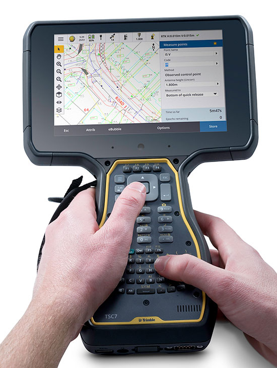
Trimble has released the Trimble TSC7 controller, a new field solution for land and civil construction surveyors. The TSC7 brings powerful enhancements to the field and was designed based on customer feedback, the company said. It provides a tablet experience with a physical keyboard and a sunlight readable 7-inch touchscreen that supports pinch, tap and slide gestures.
Users can interact with the TSC7 intuitively, easily zooming, panning and selecting items on the large touchscreen. Front- and rear-facing cameras allow users to video conference their office from the field for on-the-job support, and capture high-definition videos and images that provide valuable context to their data and clients.
Trimble TSC7 controller.
The TSC7 also leverages the power of Windows 10 Professional, driven by an Intel Pentium 64-bit quad-core processor. The processor and operating system make it easy to process data in spreadsheets and run office software programs. An ergonomic form factor, IP68-certified rugged design and optional, user-interchangeable modules make the TSC7 a flexible solution for all surveying applications.
Trimble also announced a new version of its field software, Trimble Access 2018. The software features a new user interface and powerful graphics capabilities to deliver enhanced workflows for field surveyors.
Access 2018 has been redesigned with even more intuitive menus and screen navigation to take advantage of the TSC7’s 7-inch touchscreen and computing power, while leveraging software workflows, which include applications for general survey, roading, tunnels and pipelines.
Access 2018 also integrates with the Trimble Sync Manager application to enable cloud-based data management between the office and the field. Surveyors can quickly start working by downloading preconfigured jobs in the field with DXF maps and CSV files linked ready to start surveying. Sync Manager also integrates seamlessly with Trimble Business Center software and is compatible with other industry office software platforms.
https://youtu.be/I2oMLIvu3Ck
“Today’s surveyors are managers of geospatial intelligence,” said Ron Bisio, vice president of Trimble Geospatial. “Data has more depth and complexity than ever before, and surveyors’ reputations depend on transforming that data into valuable, reliable information for their clients. The TSC7 and Access 2018 form the new backbone of our field solutions ecosystem, and give our users a leading edge to be data experts.”
Rover Systems
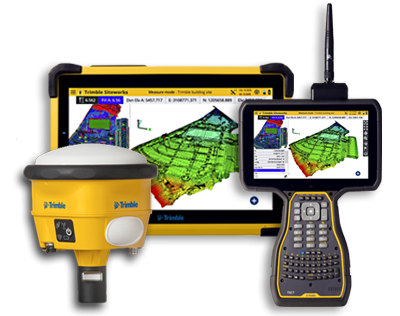
Trimble is also releasing two new rover systems for civil engineering and construction applications — the Trimble Siteworks Positioning System for Construction Surveyors and the Trimble Siteworks Positioning System for Supervisors.
Both systems feature new Siteworks Software, next-generation survey software tailored for construction workflows. Completely redesigned from the ground up, Siteworks Software features a new interface that is optimized for ease-of-use and productivity. Configurable views, colorful graphics and natural interactions and gestures make Siteworks software intuitive and easy to learn.
Siteworks Positioning System for Construction Surveyors is comprised of the Trimble SPS986 GNSS smart antenna, the TSC7 controller and Siteworks software. It enables construction surveyors to work with complex 3D models, collect large data sets faster, visualize complex 3D models more easily and work day or night efficiently.
Siteworks Positioning System for Supervisors is comprised of the SPS986 GNSS smart antenna, the Trimble T10 Tablet and Siteworks software. It enables construction supervisors to run full office software packages, including Business Center – HCE and Microsoft Office, and to work easily with data and 3D models in the field without carrying a laptop.
The Trimble TSC7 Controller running the current version of Trimble Access field software will be available worldwide in May through Trimble’s Geospatial distribution partners.
Mapping company NavVis has launched the M6, a next-generation indoor mobile-mapping system that the company says can overcome the scalability and data quality constraints of reality capture technology.
Surveyors and architecture, engineering and construction (AEC) professionals can now use reality-capture technology for large-scale indoor mapping projects. The M6 can be used for factory planning and creating and updating as-built BIM (building information modeling) models and construction monitoring.
The NavVis M6 is an all-in-one system that captures 360-degree immersive imagery, photorealistic point clouds, Bluetooth beacons, Wi-Fi signals and magnetic field data.
The NavVis M6 features a mobile lidar system that lets it scan up to 30 times faster than stationary devices, letting users capture up to 30,000 square meters in a day.
Cutting-edge 6D simultaneous localization and mapping (SLAM) technology significantly improves the quality of data captured. Thanks to 6D SLAM, M6 continuously scans even complex indoor environments, including uneven surfaces or changing elevations such as ramps, open spaces or long corridors without compromising the quality of the data.
M6’s innovative software is complemented by hardware features designed to improve the quality of data and ease of capture: four laser scanners with a range of up to 100 meters are arranged to maximize scan coverage, while six cameras automatically take high-resolution images during mapping. The innovative design of the M6 includes camera placement that keeps the operator in a blind spot.
NavVis IndoorViewer software gives stakeholders access to the scanned environment through an interactive virtual building in their browser.
“The NavVis M6 marks a quantum leap in indoor mobile mapping,” Felix Reinshagen, CEO of NavVis. “Anyone who needs to scan large properties, run repeated scans or would like to move into the field of reality capture will profit from the groundbreaking data quality.
“With M6, users can now quickly capture large, complex indoor environments for typical tasks such as updating floorplans, documenting construction progress or creating as-built BIM models. At the same time, M6 captures the data needed to provide customers with additional deliverables such as browser-based immersive walkthroughs and indoor navigation,” Reinshagen said.