Screenshot from U.S. Navy video of a March 2016 test of an F-35 releasing the AGM-154 Joint Standoff Weapon (JSOW).
Raytheon Company and the U.S. Navy completed the final developmental test to integrate the Joint Standoff Weapon C onto the F-35 Joint Strike Fighter’s C variant, keeping the low-cost, air-to-ground missile on track for full deployment in 2019.
The JSOW glide weapon uses a GPS-inertial navigation system with an imaging infrared seeker that can identify and track targets autonomously. JSOW C weighs 1,000 pounds and is effective against high-value land targets at ranges greater than 70 nautical miles, day or night, and in adverse weather conditions.
“With JSOW C in its internal weapons bay, the Navy’s F-35C can now eliminate the toughest ground targets from significant standoff ranges,” said Mike Jarrett, vice president of Raytheon Air Warfare Systems. “JSOW’s advanced warhead and smart fuse provide fighter pilots with plenty of flexibility against hard and soft targets — plus, it has many programmable effects.”
Lockheed Martin, manufacturer of the F-35, and the F-35 Joint Program Office participated in the latest test, which took place on the Navy’s China Lake ranges in California.
Lockheed Martin has submitted a competitive and fully compliant proposal for the U.S. Air Force’s GPS III Follow On (GPS IIIF) program, which will add enhanced capabilities to the most advanced GPS satellites ever designed. The GPS IIIF program intends to produce up to 22 next-generation satellites.
The U.S. Air Force’s first 10 GPS III satellites, now in full production at Lockheed Martin, are already the most powerful GPS satellites ever designed. GPS III will have three times better accuracy and up to eight times improved anti-jamming capabilities. Spacecraft life will extend to 15 years, 25 percent longer than the newest GPS satellites on-orbit today. GPS III’s new L1C civil signal also will make it the first GPS satellite to be interoperable with other international global navigation satellite systems, like Galileo.
Lockheed Martin’s proposal for the GPS IIIF program adds further power, resiliency and capabilities to GPS III.
The biggest feature of GPS IIIF will be a regional military protection capability, which will increase anti-jam support in theater to ensure U.S. and allied forces cannot be denied access to GPS in hostile environments.
Lockheed Martin’s GPS IIIF will feature a fully-digital navigation payload. The payload on the first 10 GPS III satellites is already 70 percent digital.
Each GPS IIIF satellite will include a laser retro-reflector array, which allows the positioning of on-orbit satellites to be refined with ground-based, laser precision. The precise positioning of each satellite ultimately enhances the positioning signals they generate.
Additionally, the U.S. government will provide each GPS IIIF with a new search-and-rescue payload. These hosted payloads, spread around the globe on GPS IIIF satellites, will make it easier for first responders to detect and respond to emergency signals.
“When we developed our design for the first 10 GPS III, we used a flexible, modular architecture that would allow for the insertion of modern technologies and new Air Force requirements in a low-risk manner,” said Johnathon Caldwell, program manager for Lockheed Martin’s navigation systems mission area. “In addition, our GPS IIIF solution is based off a design already proven compatible with both the Air Force’s next generation Operational Control System (OCX) and the existing GPS constellation.”
The first 10 GPS III satellites are in full production at Lockheed Martin’s GPS III Processing Facility, a $128 million cleanroom factory designed in a virtual reality environment to drive efficiency and reduce costs in satellite production.
GPS III SV02 completed rigorous Thermal Vacuum (TVAC) testing in December 2017, is in final environmental testing, and is expected to be declared AFL in summer 2018. GPS III SV03 was fully integrated in fall 2017 and recently began TVAC, and SV04 was recently integrated in anticipation of environmental testing later this summer. GPS III SV05 has now received its navigation payload and is in final vehicle build up. Not far behind, GPS III SV06 has begun its initial build with GPS III SV07 also planned to begin production this spring.
To date, more than 90 percent of parts and materials for all 10 satellites have been received, from more than 250 aerospace companies from 29 states, to help ensure GPS III maintains the gold standard in position, navigation and timing.
Australian company Cohda Wireless has released a vehicle positioning system to eliminate GPS black spots in “urban canyons” between high-rise buildings.
Using Cohda’s expertise in developing collision avoidance systems for mines, the vehicle-based system, V2X-Locate, can identify vehicle position to sub-meter accuracy in environments that degrade GPS accuracy, such as tunnels, underground carparks and between high-rise buildings.
As well as enhancing current connected vehicles, V2X-Locate delivers a critical component for connected autonomous vehicles (CAV), which will require uninterrupted positioning data to safely navigate on roads, the company said.
Image: Cohda Wireless
Cohda has designed V2X-Locate to enable equipped vehicles to identify their location using existing Smart City V2X (vehicle-to-everything) roadside infrastructure from any standards-based manufacturer.
Cohda Wireless Chief Technology Officer Paul Alexander said V2X-Locate was a globally unique product. “We solve the problem caused by GPS and satellite-based positioning systems not working in all use-cases,” he said.
“If you’re in a major downtown area with tall buildings, or in a tunnel or in an underground parking lot, a GPS system can fail, preventing it from delivering accurate results,” Alexander said. “As well as being inconvenient for current drivers, this is not an option as we enter the era of driverless cars. The V2X-Locate breakthrough is to position the vehicle with sub-meter accuracy by using the existing communications signals produced by V2X Smart City infrastructure deployments. The result is that V2X-Locate can eliminate positioning black spots in city centers where they are most likely to occur.”
Cohda Wireless demonstrated V2X-Locate in a 2017 trial in New York City, where it repeatedly demonstrated sub-meter accuracy while driving along Sixth Avenue, which has the tallest buildings in the Big Apple. Comparably tested GPS-based systems were as much as tens of meters off-course, at times showing cars driving through buildings.
Alexander said Cohda Wireless had designed V2X-Locate by using its experience developing collision avoidance technology for underground mines. “The hardest place to do positioning is one kilometer underground with a cubic kilometer of copper above your head,” he said.
“That’s where V2X-Locate was born,” Alexander said. “Cohda has worked in that area for several years, providing accurate positioning for vehicles where no GPS connectivity is available. We’ve now successfully migrated that technology from mine sites of the outback to the urban canyons of New York City.”
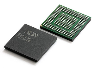
V2X_Locate uses the NXP SAF5400 single-chip modem for V2X. (Photo: NXP)
Both Cohda’s standard V2X onboard units and roadside units use the NXP RoadLINK chipset, which supports V2X-Locate’s highly accurate performance by delivering multipath channel tracking.
After a pre-release international roadshow in October last year, Cohda Wireless received strong interest in V2X-Locate from both Smart Cities and Tier 1 automotive manufacturers. To meet that demand, Cohda Wireless has released a V2X-Locate Evaluation Kit, which contains the system and four roadside unit devices, which equip prospective customers to put V2X-Locate through its paces.
Harxon Corporation is launching the single-frequency, multi-GNSS real-time-kinematic (RTK) enabled Smart Antenna TS300 series, designed for manual guidance and autosteer agriculture applications that benefit from scalable performance in positioning accuracy.
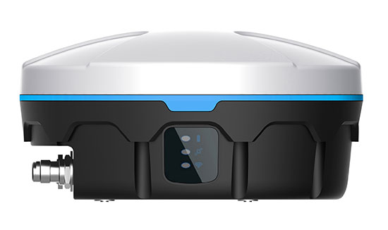
The TS300 series smart antennas are designed for manual guidance and autosteer agriculture applications. (Photo: Harxon)
The TS300 series is a multi-GNSS compatible system using GPS, GLONASS, BeiDou and Galileo for simultaneous satellite tracking to offer RTK positioning.
It is able to track any visible satellites under challenging conditions, ensuring a stable signal quality with higher precision and reliable data. Farm tractors and machines can still receive a healthy signal when the sky is partially visible or there are obstructions around the farmland.
The TS300 series features patented T-DIFF technology, providing smooth positioning and exceptional pass-to-pass accuracy. Its steady, smooth output is well suited for autosteer applications and helps the machines operate in a steady path. By reducing the impact of machine vibration during farming on complex landforms, T-DIFF technology ensures machine controlling and positioning accuracy at a centimeter level.
Powered by the latest stand-alone algorithmic technology, the TS300 series can maintain the RTK positioning accuracy for a certain period when the RTK difference link is disconnected during machine operation. It guarantees that farm machines operate effectively and accurately under poor positioning conditions.
Moreover, the TS300 series can output real-time tilt information for machines on rugged farmland. By optimizing the backend operation, it is convenient for users to improve positioning accuracy through a tilt compensation algorithm.
The data links — 3G/4G modules, external/internal radio transmission modems and Bluetooth — of the TS300 series are designed as multiple selections as required, allowing customers flexible and convenient operation in different environmental conditions.
Purpose-built for challenging environments, TS300 Series has built-in magnets to simplify mounting; fixed mounting options are also available as 5/8-inch screws and M4 screws, providing convenient and quick installation. Its IP67 ruggedized enclosure works reliably in harsh environments and is designed for professional precision agriculture applications requiring high-precision RTK positioning.
MicroStrategy Incorporated, a worldwide provider of enterprise analytics and mobility software, has launched MicroStrategy 10.11, the newest feature release to the company’s MicroStrategy 10 platform.
New capabilities in 10.11 include enhanced mapping for conducting geospatial analytics with Mapbox, a location data platform for mobile and web applications.
Version 10.11 also introduces out-of-the-box visualizations, intelligent recommendations for content, prompts for dossiers and a native MicroStrategy Library app for smartphones.
Library app. Users can now interact with data on dossiers via native apps optimized for iOS and Android smartphones. MicroStrategy customers can to operationalize the platform’s latest and modern interfaces with touch-optimized workflows on these handheld devices. Users can download the MicroStrategy Library app for iPhone by visiting the Apple app store or the MicroStrategy Library app for Android by visiting the Google Play app store, respectively.
Geospatial services powered by Mapbox. MicroStrategy 10.11 introduces MicroStrategy Geospatial Services and delivers new mapping capabilities via a native integration with Mapbox. The new and enhanced map visualization is available for dossiers on all interfaces, including MicroStrategy Desktop, MicroStrategy Workstation, MicroStrategy Web, MicroStrategy Mobile and MicroStrategy Library.
Users can visualize and analyze spatial data with advanced mapping capabilities, including intelligent clustering and aggregation, dynamic layers with interactive zoom and thresholds for attributes. This mapping service is available in addition to out-of-the-box Esri maps, and offers support for markers, bubbles and area types on a variety of map styles.
Geospatial Services features include:
Vector maps that improve performance and response times by 300% over traditional tiled maps, including for millions of records.
Global postal and administrative boundaries that let users bin their data by geographies ranging from Indian postal codes to Chinese prefectures.
Map style options tailored to the user’s visualization, including basic, light, dark, streets, topographic and satellite maps.
Advanced clustering and aggregation capabilities to understand spatial trends in data beyond density.
Full control of data layers and levels of detail based on a map’s zoom level.
Out-of-the-box visualizations. MicroStrategy 10.11 introduces three new visualizations that expand visual analytics capabilities for new use cases. With this latest release, users can plot and interact with data using waterfall, histogram and box plot visualizations, all of which are available out-of-the-box in all MicroStrategy interfaces.
“We are extremely excited about the launch of version 10.11 and all of its powerful new features. Business teams can now confidently take the first step towards establishing an enterprise-wide, data-driven culture on their own,” said Tim Lang, senior executive vice president and chief technology officer, MicroStrategy. “Version 10.11 empowers teams with self-service data discovery and departmental analytics, while creating the foundation for governed data discovery at scale and enterprise-worthy analytics. The latest capabilities available in MicroStrategy 10.11 are central to MicroStrategy’s commitment to deliver the next generation of enterprise analytics and advance our goal of building the ultimate analytics platform for the Intelligent Enterprise.”
To see MicroStrategy 10.11 in action, users can register for the upcoming webcast Unveiling MicroStrategy 10.11, to be held Wednesday, May 16,at 2 p.m. EDT.
Spirent Communications plc is working with the European Commission’s Joint Research Centre (JRC) to help implement the eCall system, which is required in new cars sold in Europe starting in April.
Experts from the JRC have been working with Spirent GNSS test equipment during the European GNSS Agency (GSA) eCall test campaign. The campaign aims to pre-test eCall in-vehicle modules and evaluate their compatibility with the positioning services provided by Galileo and the European Geostationary Navigation Overlay Service (EGNOS) in accordance with the test procedures established by the regulation.
As the eCall initiative goes live this month, the GSA launched a test initiative to support eCall device manufacturers in their preparation for type approval. In safety-critical situations, eCall must be as accurate as possible, so defining and conducting proper test procedures is imperative.
Spirent is cooperating with the JRC to develop its own eCall test solution. “Working with JRC enabled us to develop better tests to verify that eCall devices are working properly,” said Steve Hickling, product director for Spirent’s positioning business.
When a collision occurs, an eCall-equipped car automatically calls the nearest emergency centre. Even if no passenger is able to speak – such as because of injuries — a “minimum set of data” is sent, which includes the exact location of the crash site. eCall is expected to significantly reduce emergency service response times, leading to lives saved and injuries reduced.
The JRC used a Spirent GSS9000 simulator to assess eCall devices’s capability to support the reception and processing of the Galileo and EGNOS signals. Using feedback from the JRC, Spirent has developed an eCall Test Suite for its automation solution, PT TestBench.
Tested with various eCall devices, the eCall Test Suite is available for eCall device manufacturers and include, among others, positioning accuracy, time to first fix, GNSS receiver sensitivity and reacquisition performance.
Airgain Inc., a provider of advanced antenna technologies used to enable high-performance wireless networking, has released its Ultramax MIMO 9-in-1 antenna, which can receive multiple GNSS signals.
Designed for public safety fleet management, it provides high rejection GNSS technology with coverage for multiple satellite systems including GPS, GLONASS, Galileo and BeiDou.
The new Ultramax MIMO 9-in-1 antenna will help improve public safety and fleet solutions with enhanced Wi-Fi capability, the company said. It includes 6 x 6 MIMO Wi-Fi, dual LTE and multi-GNSS technology antennas in a single enclosure.
MIMO — multiple input multiple output — is used within LTE to provide better signal performance and higher data rates. With integrated 6×6 Wi-Fi antennas, the antenna provides support for full high-definition (HD) streaming video and other high bandwidth applications.
The antenna is the first in an Airgain series designed to support state-of-the-art communications technology in fleet routers, including the Cradlepoint IBR1700.
The Ultramax MIMO 9-in-1 antenna is equipped with nine ports, supporting tri-band Wi-Fi, LTE/MIMO (including Band 14 for FirstNet) and GNSS. With a single compact footprint, the antenna avoids multiple mounting and cable entry points.
“Technology advances in routers, including enhanced Wi-Fi and expanded MIMO LTE, require enabling antenna technology to deliver an optimized end user experience,” said Reed Pangborn, vice president of channel sales for North America. “We designed a new antenna to support the fleet management applications required in today’s evolving mobile environment. The Ultramax MIMO 9-in-1 antenna demonstrates our commitment to providing leading antenna solutions for our mobility customers covering a wide range of vehicles, including police, fire, ambulance and other fleet assets.”
The Ultramax MIMO 9-in-1 antenna complements Cradlepoint’s IBR1700 and supports all six of its Wi-Fi ports.
Airgain will unveil the new antenna at the Cradlepoint Global Partner Summit in Scottsdale, Arizona, April 11-12. The Ultramax MIMO 9-in-1 antenna will be available to order starting in June.
The U.S. Department of Homeland Security (DHS) has released a memorandum about a GPS rollover event coming in April 2019.
The memorandum, U.S. Owners and Operators Using GPS to Obtain Time, is intended to provide an understanding of the possible effects of the April 6, 2019, GPS Week Number Rollover on Coordinated Universal Time (UTC) derived from GPS devices.
DHS recommends that critical infrastructure and other owners and operators prepare for the rollover. They should:
investigate and understand their possible dependencies on GPS for obtaining UTC;
contact the GPS manufacturers of devices they use to obtain UTC;
understand the manufacturers’ preparedness for the ollover;
understand actions required by CI and other owners and operators to ensure proper operation through the ollover, and
ensure that the firmware of such devices is up to date.
The memorandum is sponsored by the Department of Homeland Security’s National Cybersecurity and Communications Integration Center in coordination with the Department of Homeland Security’s Science and Technology Directorate, the Department of Homeland Security’s National Protection and Programs Directorate Office of Infrastructure Protection and the National Coordination Office for Space-Based Positioning, Navigation and Timing.
GPS World discussed in-depth the previous rollover event in an Innovation column.
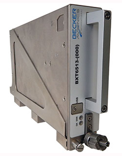
Becker Avionics has received certification for the its BXT65XX Mode S transponder, designed specifically for the rigorous flying environment characteristic of helicopter operations.
Paired with a FreeFlight Systems’ 1203C SBAS/GNSS sensor, the remote-mounted solutions provide helicopter operators a complete and cost-effective way to equip with ADS-B Out to meet the Jan. 1, 2020, mandate.
The system is a part of the company’s robust BXT65XX line of ADS-B Mode S transponders. Manufactured with a standard ARINC 429/743 output, this transponder easily integrates with the FreeFlight Systems Model 1203C SBAS/GNSS sensor for complete ADS-B Out compliance, the company said. It can also be installed either as dual installation for primary transponder interrogations or as single install for a dedicated ADS-B transmission.
The transponder can be installed on aircraft not equipped with a traffic collision avoidance system. Its enhanced privacy settings can disable both ADS-B and Mode S transmissions.
“We are pleased to announce this new milestone in our transponder product line,” said Forrest Colliver, Becker Avionics’ managing director. “This new system showcases how we tailor our compact, robust, and durable avionics to our clients’ requirements in order to provide the best solution for where and how they fly.”
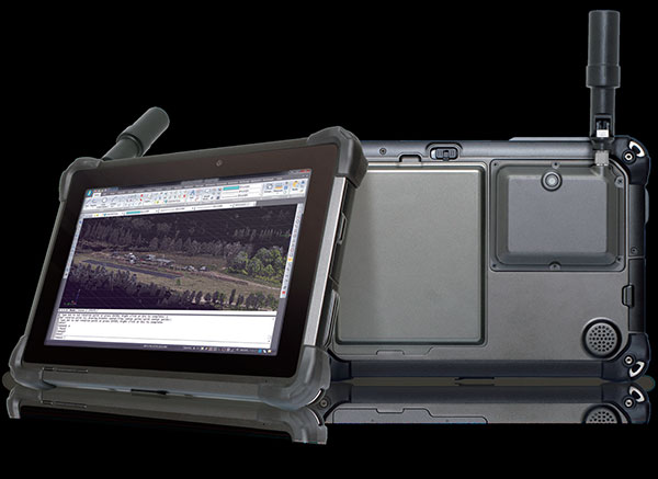
DT Research has released the DT301T rugged RTK tablet (DT301T-RTK), a lightweight military-grade tablet purpose-built for GIS mapping applications. It features real-time kinematic (RTK) satellite navigation to enhance the precision of GNSS position data.
The tablet enables 3D point cloud creation with centimeter-level accuracy, meeting the high standards required for scientific-grade evidence in court.
The DT301T-RTK is a rugged tablet with scientific-grade GNSS. (Photo: DT Research)
The DT301T Rugged RTK tablet is military-grade with an IP65 rating. Because it’s lightweight, the DT301T can be used in the field, office and vehicles, the company said.
A dual-frequency GNSS module is built into the tablet, which uses real-time reference points within 1–2-centimeter accuracy to position 3D point clouds created from aerial photogrammetry, using GPS, GLONASS and Galileo receivers. Users can measure with the RTK GNSS positioning directly using a foldable antenna or connect to an external antenna for more robust receiving and survey-grade precision.
“We’ve seen a dramatic uptick in the need for rugged tablets to be purpose-built for a range of mapping uses across industries,” said Daw Tsai Sc.D., president of DT Research. “In designing the DT301T with RTK satellite navigation, we also took into consideration the other features and capabilities necessary within a rugged tablet to quickly and easily conduct forensic mapping, land surveying, e-construction, building information modeling (BIM) and other mapping scenarios.”
The DT301T is compatible with existing GIS software for mapping applications and brings together the advanced workflow for GIS data capture, accurate positioning and data transmitting.
Uses
According to DT Research, the tablet can be used in a variety of scenarios.
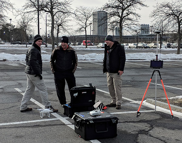
Forensic mapping. Public safety teams, investigators and crash reconstructionists can use the DT301T Rugged RTK tablet to accurately collect measurements that are scientifically defensible by using the real-time centimeter reference points to position 3D point clouds created from aerial photogrammetry or take stand-alone measurements.
DT301T-RTK tablet during forensic mapping training. (Photo: DT Research)
The results will have the precision necessary to stand up as evidence in court, said Andrew S. Klane, a former Massachusetts State Police Lieutenant who teaches Forensic Mapping and is now the chief operating officer at Forensic Mapping Solutions Inc.
“As more drones are being used for mapping, there is a growing need for ground-control positioning devices,” Klane said. “By using a DT301T Rugged RTK Tablet in combination with a drone, users can more quickly and cost-effectively create a 3D model to deliver an accurate representation of the scene with scientific-grade tolerance that will hold up in a court of law.”
It could also help clear crash scenes faster, restoring the normal flow of traffic on congested roadways, reducing secondary crashes and lowering the chance of first responders and other workers getting hurt while clearing the scene.
Land surveying. Surveyors can use the DT301T tablet to measure the altitudes, angles and distances on the land surface so that they can be accurately plotted on a map to determine property boundaries, construction layout and mapmaking.
E-construction. Construction workers can manage the collection, review, approval and distribution of highway construction contract documents in a paperless environment using the DT301 tablet.
Building information modeling (BIM). Architecture, engineering, and construction (AEC) professionals can use the tablet to create 3D models to efficiently plan, design, construct and manage buildings and infrastructure.
FEATURES
The DT301T Rugged RTK tablet has been purpose-built for precision mapping in a variety of environments and includes the following features and capabilities:
Dual-frequency GNSS module: GNSS L1 and L2 RTK that receives GPS, GLONASS and Galileo signals up to 372 channels with RMS 10 mm + 1 ppm accuracy.
High-performance CPU and Windows OS: Intel 6th-generation core i5 or i7 processor with Microsoft Windows 7 Professional or Windows 10 IoT Enterprise. Units come with either 8 GB or 16 GB of RAM.
Sunlight-readable display: A 10.1 inch LED-backlight, sunlight-readable screen with capacitive touch and 1920 x 1200 resolution.
Wireless connectivity: Long-range Class 1 Bluetooth powers connectivity up to 1,000 feet and 4G mobile broadband for LTE, HESPA+, GMS/GPRS/EDGE, EV-DO, Rev A and 1xRTT.
Storage: For field data collecting, the tablet can store up to 1 terabyte of data.
Military standards: The tablet is fully ruggedized to meet the highest durability standards with an IP65 rating, MIL-STD-810G for vibration and shock resistance, and MIL-STD-461F for EMI and EMC tolerance.
Battery pack: High-capacity hot-swappable battery pack delivers 60 or 90 watts for up to 15 hours of continuous mobile communications.
Accessories: Those available include external antennas, pole mount cradles, detachable keyboards, battery charging kits and digital pens.
The miniature UAV, smaller than a human palm, zips right to its human target — identified through facial recognition technology — and pierces the forehead with a projectile, for an instant kill.
That harrowing scene takes place in a seven-minute viral video issued by autonomousweapons.org, a non-profit sounding warning bells over potential automation of weapons. Its Campaign to Stop Killer Robots (#BANKILLEROBOTS) seeks a preemptive international ban on “fully autonomous weapons which enable strikes to be carried out without human intervention.”
“Allowing machines to choose to kill humans will be devastating our security and freedom,” warns Stuart Russel, professor of computer science at the University of California at Berkeley, on the video.
What feels like science fiction to those of us raised on the Terminator franchise could be closer than we think. Because of this, a new U.S. Army report emphasizes the need to develop countermeasures against swarming drones and other unmanned weapons.
The Army and U.S. Department of Defense have invested significantly in technologies in response to these threats, often focusing on detecting radio frequency transmissions of the UAVs or their operators.
However, as the report points out, today’s consumer and customized UAS increasingly can operate without radio frequency command-and-control links by using automated target recognition and tracking, obstacle avoidance, and other capabilities enabled by software.
The U.S. Army discusses the pros and cons of autonomous weapons in a June 2017 article in Military Review, saying an international ban should be considered on “fully autonomous weapons with missions that cannot be aborted and that cannot be recalled once they are launched. If they malfunction and target civilian centers, there is no way to stop them.”
Sobering thoughts about a future that may not be too distant.
A roundup of recent products in the GNSS and inertial positioning industry from the April 2018 issue of GPS World magazine.
OEM
GNSS RTK Board
For OEMs, system integrators
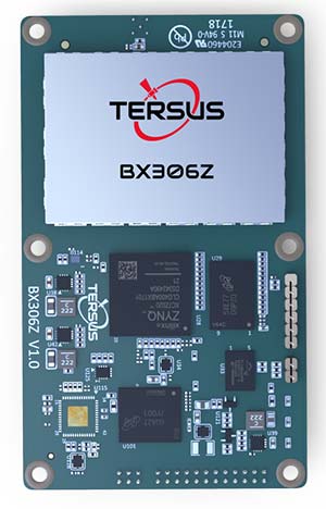
The BX306Z GNSS real-time kinematic (RTK) board has powerful flexibility and compatibility to meet the needs of original equipment manufacturers (OEMs) and system integrators. The BX306Z is a cost-efficient board for positioning and raw measurement output. The board is a compact, multi-GNSS (GPS L1/L2, GLONASS G1/G2, BeiDou B1/B2) RTK module with centimeter-level accurate positioning capability. It is able to integrate with autopilots and inertial navigation units. Log and command is compatible with major GNSS boards.
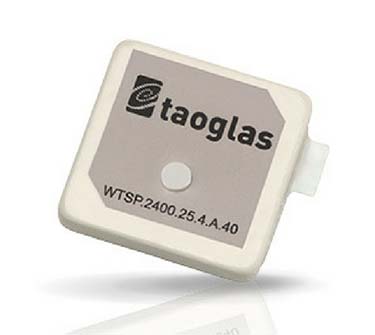
The Taoglas Terrablast antenna line is designed for UAVs and transportation. (Photo: Taoglas)
Rugged antennas
For automotive, drone markets
Terrablast polymer-based patch antennas are 30 percent lighter than their ceramic counterparts and extremely resistant to fracture upon impact. They are designed for the automotive and unmanned aerial vehicle (UAV) markets, where impacts are possible but antenna performance cannot be compromised. The 35-mm GPS/GLONASS/BeiDou patch antenna has high efficiency of more than 70 percent across all bands, improving time to first fix. All Terrablast antennas undergo rigorous temperature, vibration and impact tests, exceed ISO 16750 standards, and are manufactured in Taoglas’ purpose-built facilities in Taiwan and the United States.
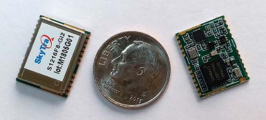
The S1216F8-GI2 is a NavIC + GPS/GAGAN receiver module for emerging intelligent transport systems (ITS) applications requiring NavIC/GPS capability in India. It integrates an L1/L5 RF front-end and baseband processor capable of receiving up to 14 L5 NavIC signals and up to 20 L1 GPS/GAGAN signals simultaneously. With six NavIC signals and three GAGAN signals, it offers 18–23 usable signals, providing improved accuracy in urban canyons. The S1216F8-GI2 is form-factor and pin-out compatible with 12 x 16-millimeter modules, enabling drop-in replacement. NavIC sub-frame data outputs broadcast warning messages for weather alerts and natural disasters. The S1216F8-GI2 is manufactured with ISO/TS 16949 automotive certification.
To meet stringent requirements in harsh environments
The automotive-grade MAX‑M8Q‑01A GNSS module measures 9.7 x 10.1 x 2.5 millimeters and has an operating temperature range from –40° C to 105° C. It is designed to meet the stringent requirements of the automotive market, providing superior positioning accuracy even in challenging environments such as urban canyons. Its temperature range ensures reliable performance in harsh environments, such as when mounted in a car‑roof antenna.
The Teseo APP receiver enables safer autonomous driving. The multi-frequency GNSS receiver chipset is suitable for safety-critical automotive applications and high-accuracy positioning at the decimeter and centimeter levels for precise point positioning (PPP) and RTK applications. By tracking satellites of all GNSS constellations simultaneously on at least two of the frequencies used by each system, ST’s automotive-quality Teseo APP (automotive precise positioning) receiver provides high-quality raw GNSS data for PPP and RTK algorithms, which allows accurate positioning and rapid convergence time worldwide. The receiver monitors the integrity of the satellite data to alert the system if accuracy is degraded for any reason. This permits Tier-1 manufacturers to certify safety-critical systems in accordance with ISO 26262.
Qinertia post-processing kinematic software has been designed to help surveyors get the most of their surveys. After the mission, Qinertia gives access to offline real-time kinematic (RTK) up-to-date corrections from more than 7,000 base stations in 164 countries. By creating a virtual base station near a project, the software delivers the highest level of accuracy without having to set up a base station. An advanced tight coupling algorithm delivers high accuracy and maximizes RTK availability. Trajectory and orientation are greatly improved by processing inertial data and raw GNSS observables in forward and backward directions, especially in challenging environments. With Qinertia, surveyors can quickly identify and solve issues such as mechanical installations or sensor alignment.
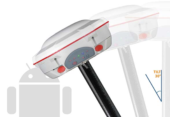
The T300 Plus GNSS receiver is designed for demanding surveying tasks, with full-constellation tracking capability, tilt compensation, 4G/Wi-Fi connection, 8-GB internal memory and an easy survey workflow with Android-based Survey Master Software. It is designed to make collecting accurate data easy and fast, whether done by a beginner or experienced professional surveyor. As an upgrade of the T300, SinoGNSS T300 Plus combines a GNSS board, Bluetooth and adjustable TX&RX UHF, Wi-Fi and 4G modem into one rugged device. Its built-in 4G modem ensures the T300 Plus works with all kinds of continuously operating reference stations (CORS) worldwide. A built-in tilt sensor supports maximum 30° pole tilt and keeps the compensation accuracy within 3 centimeters; the user can check the electronic bubble on the controller for fast surveys in the field.
Atlas-capable GNSS receiver for precision 3D applications
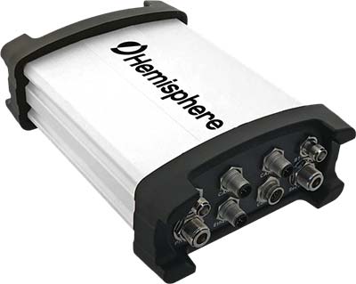
The Vector V1000 GNSS receiver is designed for precision marine applications, such as hydrographic and bathymetric surveys, dredging, oil platform positioning, buoys and other applications that demand the highest level 3D positioning accuracies. It provides high-accuracy heading, position, pitch, roll and heave data. The V1000 supports multi-frequency GPS, GLONASS, BeiDou, Galileo, QZSS and IRNSS (with future firmware upgrade and activation) for simultaneous satellite tracking. The receiver is powered by Hemisphere’s Athena real-time kinematic (RTK) engine and is Atlas L-band capable. Based on Hemisphere’s Eclipse Vector technology, the V1000 uses the most accurate differential corrections including RTK and Atlas L-band. It has an integrated display that can be conveniently installed near the operator. The V1000 has heading accuracy of better than 0.01 degree when using a 10-meter antenna separation.
Machine-to-machine (M2M) and internet of things (IoT) device
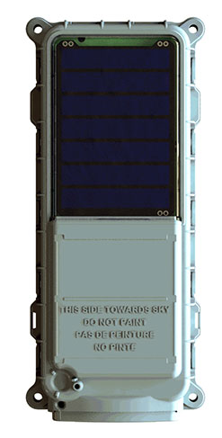
The SmartOne Solar M2M/IoT device is solar-powered and offers Bluetooth Low Energy connectivity while addressing the growing global demand for reliable and affordable remote monitoring and automated data collection of assets located both within and beyond terrestrial networks. The SmartOne expands the market for remote connectivity to include assets that are otherwise difficult or expensive to reach for power replacement, and lowers the operating cost of monitoring assets being served by legacy SmartOne products. SmartOne Solar’s rechargeable batteries can deliver more than eight years of serviceable life. Without exposure to the sun, a fully charged unit can operate for many months while reporting twice daily. The product’s Bluetooth connectivity allows wireless device configuration and firmware upgrades in the field.
Designed for large-scale surveying and mapping projects
The WingtraOne post-processed kinematic (PPK) drone is the result of collaboration with Pix4D and Septentrio. It is able to deliver orthomosaic maps and 3D models with an absolute accuracy down to 1 centimeter (cm), offering broad coverage and high resolution with ultra-precise accuracy. The WingtraOne can cover 130 hectares (320 acres), equivalent to 240 football fields, in a one-hour flight, and deliver maps at ground sample distances below 1 cm/pixel. Vertical take-off and landing (VTOL) offers hands-free operation and a smoother ride for onboard sensors as well as greater coverage than comparable multi-rotor UAVs. PPK computes ultra-precise geolocations for each image by combining the GNSS data with correction data from a nearby reference receiver. It offers a root-mean-square (RMS) error of 1.3-cm horizontally and 2.3-cm vertically without any ground control points.
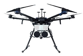
DroneHunter is a fully autonomous UAS airspace defense solution. The intelligent robotic aircraft is enabled with TrueView radar designed and engineered for physical remediation of intruder or threatening drones. DroneHunter is an autonomous UAS perimeter detection and protection solution designed to quickly detect, classify and secure against drones and other UAS. When an intruder drone is discovered, DroneHunter can engage autonomously via artificial intelligence (AI)-directed detection, tracking and guidance. Once the rogue drone is identified and the threat level analyzed, DroneHunter safely remediates the threat day or night, at a safe stand-off distance, with no collateral damage. DroneHunter supports multiple drone platforms based on use-case requirements.