SBG Systems has released the Navsight marine solution, a full high-performance inertial navigation solution designed to make surveyors’ tasks easier in both shallow and deep water.
Navsight consists of an inertial measurement unit available at two different performance levels (from shallow to deep water). According to SBG Systems, the Navsight marine solution is based on 10 years of the company’s experience in marine inertial sensing products.
Whether the IMU comes with a surface or a subsea enclosure, they are all lightweight and easy to install, the company said. Navsight connects to any computer, with no software installation. Once connected through Ethernet, the web interface guides the user to configure the solution.
A 3D view of the boat shows the entered parameters so that the user can check in real time the installation. Navsight allows quick installation and initialization thanks to new mechanical calibration module. The embedded filtering controls and validates lever arms and antenna alignment during this procedure.
Navsight Marine Solution provides high-performance motion and navigation data as well as a real-time heave accurate to 5 cm, which automatically adjusts to the wave frequency, SBG Systems said.
To allow surveying when wave frequencies are large or complex, Navsight comes with a delayed heave feature resulting in a heave accurate to up to 2-cm computed in real-time with a little delay.
If higher performance is required, the surveyor can count on SBG INS/GNSS post-processing software named Qinertia. By processing inertial and GNSS raw data forward and backward, Qinertia greatly increases accuracy especially during GNSS outages; it also fixes set up mistakes.
Highly versatile, Navsight comes as a Motion Reference Unit, providing roll, pitch and heave or as a full navigation solution with embedded tri-frequency GNSS receiver, or using an external one. Fusing inertial data with satellite position in real-time, Navsight INS offers continuous position in all conditions, such as surveying under a bridge, or during a GNSS outages due to coastal infrastructures (buildings, harbor cranes, etc.).
The Navsight Marine Solution supports RTK and every precise point positioning service (Marinestar, TerraStar, etc.). It is compatible with the main hydrographic software such as Hypack, QINSy or Teledyne PDS for seamless integration into existing workflows.
Navsight is ITAR-free. All models are available for order. Ordering information and delivery time are available from SBG Systems representatives and authorized SBG Systems dealers.
The Singapore Land Transport Authority (LTA) has begun testing an Automatic Number Plate Recognition (ANPR) camera system with Dedicated Short Range Communications (DSRC) beacons at various locations along expressways and major thoroughfares.
The testing started March 26 and will conclude in 2019.
An example of the equipment that will be mounted on existing roadside infrastructure. (Image: LTA)
The use of ANPR technology will facilitate enforcement, while DSRC beacons will also be installed in some areas to enhance positioning accuracy in Singapore’s highly urbanized environment.
The tests will enable LTA to determine the performance and reliability of such technologies under various real-life environmental and traffic conditions for future traffic management systems that will leverage GNSS technology.
The technologies being tested do not require heavy physical infrastructure and will be mounted on existing roadside infrastructure such as overhead bridges, overhead gantry signages and lamp posts, as well as EMAS gantries.
Testing equipment will also be mounted onto vehicles, which will be deployed at localized areas such as Tuas South from April 2018, before expanding island-wide for testing.
In 2016, LTA awarded a S$556 million contract to the consortium of NCS and Mitsubishi Heavy Industries Engine System Asia to build a next-generation electronic road pricing system based on GNSS technology, reports Channel NewsAsia.
The new system will allow motorists to be charged according to distance traveled on congested roads, removing the need for physical gantries.
An example of the equipment that will be mounted onto vehicles. (Image: LTA)
Police say a video from the Uber self-driving car that struck and killed a woman on March 18 shows her moving in front of it suddenly, according to Bloomberg Technology.
Uber Technologies Inc. halted its autonomous vehicle tests after one of its cars struck and killed a woman in Tempe, Arizona, in the first pedestrian fatality involving the technology.
A backup driver was behind the wheel but not operating the vehicle. “The driver said it was like a flash, the person walked out in front of them,” Sylvia Moir, the police chief in Tempe, Arizona, told the San Francisco Chronicle. “His first alert to the collision was the sound of the collision.”
The Uber had a forward-facing video recorder, which showed the woman was walking a bike at about 10 p.m. and moved into traffic from a dark center median.
“It’s very clear it would have been difficult to avoid this collision in any kind of mode,” Moir said.
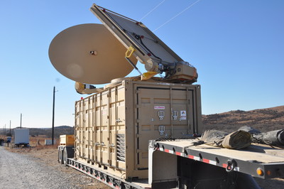
Forty-five unmanned aerial vehicles and drones fell out of the sky during a U.S. Army exercise after Raytheon’s advanced high-power microwave and laser dune buggy engaged and destroyed them.
These common threats were knocked down during a Maneuver Fires Integrated Experiment (MFIX), held in December at the Fires Center of Excellence at Fort Sill, Oklahoma.
The directed energy system emits an adjustable energy beam that renders drones unable to fly. (Photo: U.S. Army)
The directed energy system emits an adjustable energy beam that, when aimed at airborne targets such as drones, renders them unable to fly.
The MFIX event brought military and industry leaders together to demonstrate ways to bridge the Army’s capability gaps in long-range fires and maneuver short-range air defense.
Raytheon’s high-power microwave system engaged multiple UAV swarms, downing 33 drones, two and three at a time.
Raytheon’s high-energy laser, or HEL, system identified, tracked, engaged and killed 12 airborne, maneuvering Class I and II UAVs, and destroyed six stationary mortar projectiles.
The vehicle-mounted laser is installed on an all-terrain Polaris militarized vehicle. (Photo: U.S. Army)
The vehicle-mounted laser combined a solid state laser with an advanced variant of the company’s Multi-Spectral Targeting System and installed them on a small, all-terrain Polaris militarized vehicle.
The system delivers 300 seconds of invisible, precise and instantaneous energy and five hours of intelligence, surveillance and reconnaissance from a single charge, Raytheon said.
Coupled with a generator, the HEL weapon system provides military members with counter-UAV capabilities and a virtually unlimited magazine.
“The speed and low cost per engagement of directed energy is revolutionary in protecting our troops against drones,” said Thomas Bussing, Raytheon Advanced Missile Systems vice president. “We have spent decades perfecting the high-power microwave system, which may soon give our military a significant advantage against this proliferating threat.”
Raytheon and the U.S. Air Force Research Laboratory worked together under a $2 million contract to test and demonstrate high-power microwave, counter-UAV capabilities.
“Our customer needed a solution, and they needed it fast,” said Ben Allison, director of Raytheon’s HEL product line. “So, we took what we’ve learned and combined it with combat-proven components to rapidly deliver a small, self-contained and easily deployed counter-UAV system.”
Swift Navigation has released Skylark, a cloud-based GNSS corrections service delivering centimeter-level accuracy without deploying and maintaining a GNSS network. Skylark targets autonomy applications at scale and enables high-precision positioning for mass market automotive and autonomous vehicle applications.
Skylark works with both of Swift’s multi-band, multi-constellation GNSS receivers, the Piksi Multi and the Duro ruggedized industrial receiver. Swift added GLONASS support in its 1.4 firmware upgrade, announced earlier this month, and aims to include Galileo and BeiDou in the near future.
Previously known as a hardware company, Swift Navigation appears to be shifting its focus a bit, including an Internet-delivered service in addition to its GNSS receivers. It has recently focused more closely on the automotive sector; it also has customers in drone technology, robotics and precision agriculture.
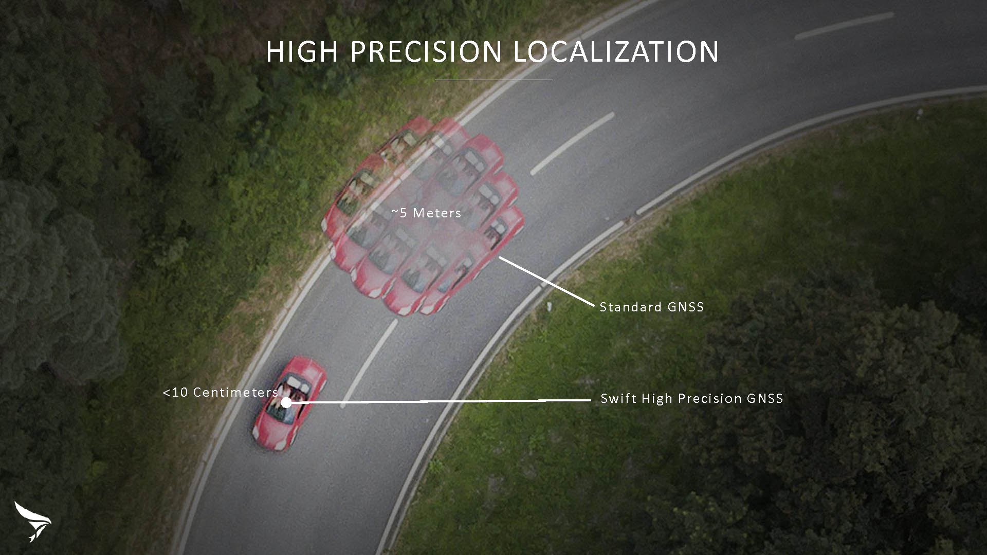
Its new platform for high-precision GNSS navigation of autonomous vehicles, via Internet connectivity, Skylark delivers fast convergence times measured in seconds, using positioning algorithms to provide a continuous stream of data to individual devices from the cloud. The data stream allows for quick and robust positioning and high reliability and availability, even in challenging environments, according to the company.
The Skylark service offers accuracy at the centimeter level. (Image: Swift Navigation)
Critical requirements for real-time absolute localization through GNSS for the automotive sector, according to Fergus Noble, co-founder and CTO of Swift Navigation, are:
high accuracy; centimeter level
availability; fast convergence, measured in seconds
integrity
scalability to support a large vehicle population
low cost.
Internet-Delivered via Cell Network
The last two requirements are fulfilled by the cloud-based approach. He characterized Skylark as a hybrid of RTK (Real Time Kinematics) and PPP (Precise Point Positioning) approaches augmented by Swift’s intellectual property, with corrections delivered over the Internet as provided by the cellular network, which he described as “robust to outages.” Cell coverage along road networks is good, Noble asserted, and 5G applications are increasing that coverage and will further enable connected vehicles. Automotive OEMs are comfortable with the level of cell coverage for this application, according to him. There has been testing to show robustness in most rural areas, and network operators are dedicated to increasing this.
“Skylark operates like a utility,” said Noble. “It is a simple, low-cost Internet data stream that provides customers with a complete high-integrity GNSS solution. Simply supply a Swift receiver with power and Internet connectivity and get real-time corrections for highly-dynamic GNSS applications.”
To realize the Skylark service, the company hired a team of cloud-based engineering experts who had a role in building Amazon and Oracle critical infrastructure. Swift Navigation is initially launching only with its own devices, but is making the service publicly-available for any customer in any vertical requiring precise positioning. “Every car company is building in autonomous functionality,” noted Noble, making clear who the company is ultimately targeting.
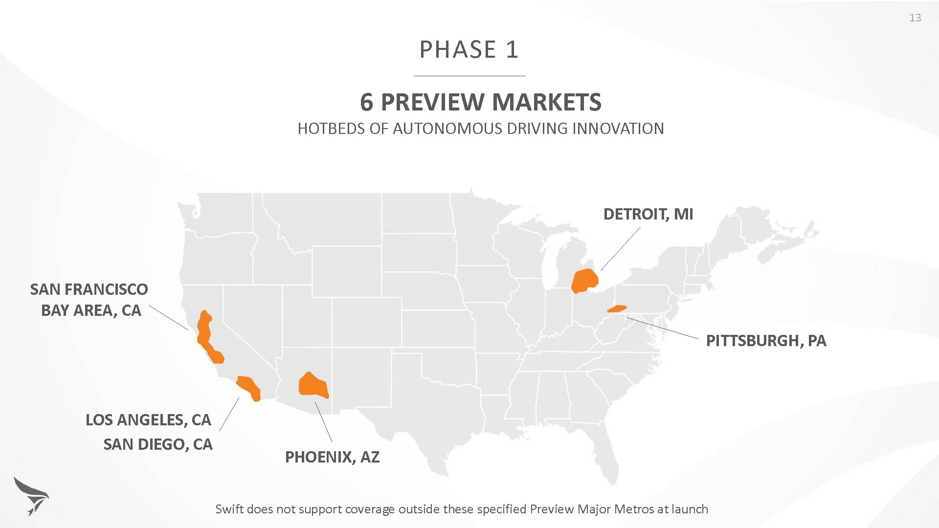
Skylark is currently offered in six metropolitan markets. (Image: Swift Navigation)
Swift has been working with beta customers for more than a year and is now previewing the service to all customers in six metropolitan markets: the San Francisco Bay Area, Los Angeles, San Diego, Phoenix, Pittsburgh and Detroit. The company envisions full contiguous U.S. and ultimately global expansion. Customers in preview areas with Swift receivers can sign up for Skylark and immediately start receiving corrections.
The service maintains low bandwidth to save on data costs and is offered with a free 30 day trial and flexible pricing plans. Skylark’s pricing structure includes a monthly plan and an annual plan. Enterprise pricing is available for volume orders.
Voyage Self-Driving Car Active Service and Coming Expansion
An early beta user of the service, Voyage deploys self-driving taxis in private communities across North America. “Skylark and Piksi Multi are working safely and efficiently in a real-world application today at The Villages, a retirement community in San Jose, California,” said Oliver Cameron, co-founder & CEO of Voyage.
Voyage incorporates Skylark GNSS corrections in controlled road networks in private communities. (Image: Swift Navigation)
Voyage’s passenger cars carry a roof-racked suite of sensors: the Swift Navigation Piksi Multi GNSS receiver, LiDAR, cameras, radar, and an inertial measurement unit. A computer in the trunk integrates all sensor signals and uses the car’s CAN bus to operate steering, braking, and other functions. An operator sits behind the wheel at all times, sometimes with a co-pilot: one to watch the road ahead, and one to watch the software. “Safety is our first priority,” said Cameron.
The service is especially valuable to customers with mobility limitations that might prevent them from walking to an event or moving within the community. (Image: Swift Navigation)
The Voyage fleet stays within the bounds of a given community, where all roads have been precisely mapped, speed limits are lower and traffic patterns are more clearly defined than in metropolitan cities. The first in the San Jose area serves private community of more than 4,000 residents, with a 15-mile road network. Today, residents are able to summon a Voyage self-driving taxi using a smartphone app and have a ride waiting at their front door. This service is especially valuable to customers with mobility limitations that might prevent them from walking to an event or moving within the community. Voyage takes residents of The Villages to and from the gym, to visit with friends, to the golf course and to community center events.
Image: Swift Navigation
Voyage will next deploy the Swift product suite in its upcoming deployment launching to 160,000 retirees at The Villages complex in Florida, over a road network of 750 miles. It is currently in a “Q/A” testing phase on that site, working the technology and the local mapping through their paces.
The U.S. Federal Railroad Administration (FRA) released a status update on its efforts to assist railroads in implementing positive train control systems (PTC), along with the railroads’ self-reported progress for the fourth quarter of 2017.
The FRA said in a press release that it is taking a proactive approach to ensure railroads acquire, install, test and fully implement certified PTC systems in time to meet the congressional interim deadline of Dec. 31.
“It is the railroads’ responsibility to meet the congressionally mandated PTC requirements,” said FRA Administrator Ronald L. Batory. “The FRA is committed to doing its part to ensure railroads and suppliers are working together to implement PTC systems.”
Between Jan. 2 and Feb. 14, FRA’s leadership hosted face-to-face meetings with executives from each of the 41 railroads subject to the statutory mandate to evaluate each railroad’s PTC status and learn what remaining steps each needs to take to have a PTC system fully implemented by the December deadline or, at a minimum, to meet the statutory criteria necessary to qualify for an alternative schedule.
The FRA is now meeting with PTC suppliers to learn more about their capacity to meet the high demands for railroads’ implementation of PTC systems in a timely manner.
PTC systems are designed to prevent certain train-to-train collisions, over-speed derailments, incursions into established work zone limits, and trains going to the wrong tracks because a switch was left in the wrong position.
All railroads subject to the statutory PTC implementation mandate must implement FRA-certified and interoperable PTC systems by the end of the year.
Under the Positive Train Control Enforcement and Implementation Act of 2015, however, Congress permits a railroad to request FRA’s approval of an “alternate schedule” with a deadline beyond Dec. 31, 2018, but no later than Dec. 31, 2020, for certain non-hardware, operational aspects of PTC system implementation.
The congressional mandate requires the FRA to approve a railroad’s alternative schedule with a deadline no later than Dec. 31, 2020, if a railroad submits a written request to FRA that demonstrates the railroad has met the statutory criteria set forth under 49 U.S.C. § 20157(a)(3)(B).
The fourth quarter data, current as of Dec. 31, 2017, shows PTC systems are in operation on approximately 56 percent of freight railroads’ route miles that are required to be governed by PTC systems — up from 45 percent last quarter and 16 percent on Dec. 31, 2016. Passenger railroads have made less progress, with PTC systems in operation on only 24% of required route miles, unchanged from the previous quarter.
The latest data confirms that railroads continue to make progress in installing PTC system hardware, with 15 railroads reporting they have completed installation of all hardware necessary for PTC system implementation and another 11 railroads reporting they have installed over 80% of PTC system hardware. In addition, all but three railroads report having acquired sufficient spectrum for their PTC system needs.
For more key implementation data for the fourth quarter, see the infographics here.
To view the public version of each railroad’s Quarterly PTC Progress Report (Form FRA F 6180.165, OMB Control No. 2130-0553) for Quarter 4 of 2017, visit each railroad’s PTC docket on https://www.regulations.gov/. Railroads’ PTC docket numbers are available at https://www.fra.dot.gov/Page/P0628.
STMicroelectronics has confirmed the validation of its LSM6DSL 6-axis inertial sensor and LPS22HB pressure sensor for the Alibaba internet of things (IoT) ecosystem, which enables users to create complete IoT nodes and gateway solutions with better time to market.
Launched in 2017, AliOS Things is a light-weight embedded IoT operating system developed by Alibaba. The company recently released AliOS Things v1.2, which includes a sensor-based component called uData.
The ST sensors that have passed the AliOS validation have been integrated in uData, and the two companies are cooperating on the development of IoT systems that aim to improve end-user experiences.
The LSM6DSL is a system-in-package featuring a 3D digital accelerometer and a 3D digital gyroscope that operates at 0.65 mA in high-performance mode and enables always-on low-power features for an optimal motion experience for the consumer.
According to the company, high robustness to mechanical shock makes the LSM6DSL the preferred choice of system designers for the creation and manufacturing of reliable products. The LSM6DSL supports main OS requirements, offering real, virtual and batch sensors with 4 Kbytes for dynamic data batching.
The LPS22HB is an ultra-compact piezo-resistive absolute pressure sensor that functions as a digital output barometer. Dust-free and water-resistant by design, the sensor enables high accuracy and low-power operation. It is available in full-mold package with silicon cap and six 20-µm holes guaranteeing sensor moisture resistance, relative accuracy of pressure measurement 0.1 mbar, and very low power consumption (12 µA in low-noise mode).
“The validation by Alibaba of ST’s LSM6DSL and LPS22HB sensors is an important achievement,” said Collins Wu, marketing director, Analog and MEMS Group, Greater China & South Asia, STMicroelectronics. “Creating and connecting nodes quickly and securely is facilitated by the holistic platform of AliOS, which cuts time to market for users and allows them to create IoT systems in China quickly for applications in smartphones, smart watches, smart locks, smart parking and beyond. On top of this, Alibaba is collaborating closely with ST to integrate more products in the platform, offering compelling IoT solutions for customers.”
Telit’s two latest modules are aimed at the European internet of things (IoT) market.
Modules WE866E4-P and ME910C1-E2 are designed to meet European specifications requirements, providing the ability to bring advanced IoT applications to market such as smart buildings, smart energy, industrial applications, medical devices and others.
“Our modules were designed with the European market in mind, eliminating the guesswork associated with what standard to use for IoT projects in the region,” said Yossi Moscovitz, Telit president of products and solutions. “We are providing the industry the ability to digitally transform by creating new opportunities for our customers to achieve innovation. We’re pleased to be a key part of enabling the promise of Smart IoT that we are seeing during this week’s conference.”
The WE866E4-P is a fully integrated dual-band, dual-mode combo Wi-Fi (802.11 a,b,g,n) and Bluetooth Low Energy (BLE) 5.0 module, with an small footprint (285 sq. mm) that provides a cost-effective way for manufacturers to add wireless connectivity to the products. It has an integrated tri-core system-on-chip with dedicated CPUs for IoT applications, Wi-Fi and BLE.
The module is self-contained with full Wi-Fi, BLE and TCP/IP networking stacks along with a complete suite of security features such as secured boot, Flash encryption, copy protection, HTTPS and WPA/WPA2 personal and enterprise security modes.
The ME910C1-E2 is a member of Telit’s flagship xE910 module family delivering 4G radio access technology in the 28.2 x 28.2 x 2.2 mm family form factor. This module increases the addressable market for LTE technology to include a broad range of new applications and use cases best served with lower maximum data rate, ultra-low power, reduced complexity and cost, and is capable of Cat M1, NB-IoT and 2G fallback. Examples of use are smart meters, industrial sensors, health-care monitors, home automation, asset tracker and other low-data-rate IoT devices.
For more information please visit Telit during this week’s Smart IoT Conference in London at Stand T2865.
Comtech Telecommunications Corp.’s Enterprise Technologies group has been awarded a $10.1 million multi-year contract from a major U.S. mobile network operator for its hosted, advanced location-services platform. The order includes development, deployment and support.
The Comtech platform leverages its Position Determining Engine to deliver precise location information of devices for applications such as turn-by-turn navigation, family finder and remote workforce management.
Secure and completely standards-based, the solution is hosted outside the operator’s network and ensures interoperability across all device providers, the company said.
“Network operators require their location services platform to be reliable, accurate, scalable and secure – and we have delivered on all fronts,” said Fred Kornberg, president and CEO of Comtech Telecommunications. “We are honored to be chosen by this customer and believe that this agreement again validates our industry-leading expertise in deploying advanced location services.”
Comtech Telecommunications designs, develops, produces and markets innovative products, systems and services for advanced communications solutions. The company sells products to a diverse customer base in the global commercial and government communications markets.
Sygic is partnering with innovative addressing system what3words.
According to Sygic, its business solutions and consumer apps are used by more than 200 million drivers and 2,000 fleets worldwide including Amazon. Sygic is also the first GPS app to partner with Ford.
The partnership will initially focus on Sygic’s business solutions for taxi, public transport, delivery and construction clients with the aim of a wider integration into Sygic’s commercial products. Clients will be able to turn on three-word addressing within their existing solutions in the coming months.
what3words is a location reference system that has divided the world into 57 trillion 3 x 3-meter squares, each with a unique three-word address. For example, “///droplet.outings.panel” will take you to the front door of Sygic’s headquarters in Bratislava.
“Sygic is committed to exploring the boundaries of navigation, a philosophy that has directly contributed to our enduring reputation as the leader in navigation,” said Martin Strigac, Sygic CEO. “what3words is the simplest way to talk about location and its rapid adoption across sectors means it is quickly becoming a standard. To get from A to B,, you need a map, navigation and to know precisely where A and B are. With what3words, we can now offer a world-class solution across all of these.”
“In-car navigation relies on an antiquated street and postal address system that is no longer fit-for-purpose,” said Chris Sheldrick, CEO and co-founder of what3words. “Poor addressing leaves drivers frustrated and means businesses waste millions every year. We are delighted to partner with Sygic to offer their business customers a more efficient solution to the last-mile challenge.”
Sygic featuring what3words will be showcased at the Post & Parcel Conference, being held March 20-22 in Berlin.
Tersus GNSS is now offering its David real-time kinematic (RTK) GNSS receiver with seven new base/rover kits.
Tersus GNSS is a provider of centimeter-accuracy GNSS RTK solutions. The Tersus David GNSS receiver with its components create an affordable solution delivering high-precision signal reception, integrated in a small, and lightweight package.
The David GNSS receiver supports GPS L1/L2, GLONASS G1/G2 and BeiDou B1/B2. With David, surveyors users can take full advantages of common platforms such as smartphones, tablets or traditional handheld modules to collect data.
Coupled with an external antenna, the Survey App and post-processing software, the David GNSS receiver is a low-cost solution for all survey applications, including real-time RTK positioning and data collection for PPK.
Four (4) GB on board an embedded multimedia card (eMMC) makes it easy to save data for post processing. The compact, IP67-rated enclosure and versatile accessories alleviate most inconveniences encountered in field work.
“The launch of David GNSS Receiver marks a major step forward for Tersus as well as for surveying professionals,” said Xiaohua Wen, founder and CEO of Tersus. “The David is a cost-efficient and palm-sized GNSS receiver. Tersus is constantly working to make each surveying task easier and more productive by providing high-quality GNSS RTK surveying equipment. Our focus is on enabling surveying professionals make data collection more convenient, post (data collection) processing more accurate, and better equipping them to do surveying in the field.”
Mobile-scanning company Viametris has launched the bMS3D backpack mobile scanning system, which features an embedded 360° camera.
Narrow streets and pedestrian zones are considered hurdles when it comes to mobile scanning. The new bMS3D-360 makes these tasks achievable. It is now available on the market and it comes with post-processing software. It will be presented at SPAR 3D 2018 in June.
“Users of mobile scanning systems know how difficult it is to cover an entire city with this kind of system and how complex the completeness is,” said Jerome Ninot, founder of Viametris.
Improved Data Exploitation with Panoramic Images. Viametris has found a solution to scanning challenges by developing the bMS3D-360: the mobile scanning backpack system includes a panoramic camera. This sensor allows the user to maintain continuity of results with mobile mapping systems on cars that already include this kind of camera. Operation and visualization with such 360° images are now easy to use.
Since Google provided massive street views, people are used to navigating through panoramic images. Navigating through bMS3D-360 images becomes easy and intuitive compared to navigating with 3D point clouds, the company said.
Ten years of experience have allowed Viametris to produce its GNSS mono-antenna system based on GNSS-free scanning (indoor or denied-GNSS area): the system trajectory is calculated by lidar-SLAM. It produces colorized point clouds with absolute accuracy of less than 5 centimeters under appropriate satellite reception conditions.
Compared to many mobile scanners, this backpack does not rely on GNSS to work. If the GNSS reception is not good enough, control points can be added for absolute localization. The backpack can be used to scan all sorts of indoor areas such as airports, industrial buildings or shopping malls.
The bMS3D-360 is lightweight. It protects the retractable camera an all other components since it is self-contained.
Post process in VIAMETRIS PPiMMS Software. PPiMMS post-processing software manages the dataset coming from the system. Its mission is to calculate, control and improve the trajectories by calling lidar-SLAM functions, and reducing drifts, thanks to loop closure algorithms.
The user can manually add GCPs to constrain the result when GNSS reception is poor. But, in most cases, the user will be able to include post-processed global positions (PPK) using GNSS post-processing software. Additionally, the panoramic camera can be used to colorize the point cloud using PPiMMS.
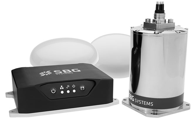 Navsight consists of an inertial measurement unit available at two different performance levels (from shallow to deep water). According to SBG Systems, the Navsight marine solution is based on 10 years of the company’s experience in marine inertial sensing products.