Eric Liberty of Applanix, a Trimble company, gives an overview of Applanix’s POS AV, POS AVX 210 and TIMMS indoor mobile mapping system at INTERGEO 2015, which was held Sept. 15-17 in Stuttgart, Germany.
POS AV is a hardware and software system specifically designed for direct georeferencing of airborne sensor data.
The POS AVX 210 is a GNSS-inertial solution designed for mapping with small and medium format cameras. The positioning components are now smaller and integrate MEMS technology.
TIMMS (Trimble’s Indoor Mobile Mapping System) captures spatial data of indoor and other GNSS-denied areas of all sizes and locations, according to Trimble. It provides both LiDAR and spherical video of a facility, enabling the creation of accurate, real-life maps or models of interior spaces.
Broadcom Corporation has announced a new GNSS chip for Internet of Things (IoT) and wearable devices that simplifies integration of GNSS into low-cost products. The advanced chip enables devices such as fitness bands to deliver pinpoint location while consuming minimal power and in some cases can eliminate the need for a separate microcontroller (MCU).
The Broadcom BCM47748 removes a bulk of the signal processing from the device MCU by calculating position, velocity and time (PVT) on-chip, delivering significant system power savings. The chip uses intelligent firmware to extend battery life while also maintaining accuracy in speed, distance and position for an enhanced user experience.
Broadcom At ION GNSS+: Broadcom’s Stephen Mole is presenting on the topic of achieving low power consumption in wearables at ION GNSS+ 2015, taking place Sept. 14-18 at the Tampa Convention Center in Florida. Stephen will present during the A5 session, Applications using Consumer GNSS, on Friday, Sept. 18, at 9:40 a.m. inRoom 23.
“Broadcom is extending its navigation leadership into the IoT ecosystem by helping customers deliver a premium location experience without compromising battery life or requiring a costly, power-hungry host processor,” said Prasan Pai, Broadcom senior director, Wireless Connectivity. “With more consumers demanding GNSS in a wider variety of applications, we see a tremendous opportunity to expand our reach into new devices with market-leading GNSS technology.”
By absorbing location computations on-chip, Broadcom not only reduces power consumption but can also dramatically lower costs for original equipment manufacturers (OEMs) by replacing the device MCU and reducing board space. Additionally, firmware inside the BCM47748 automatically adapts to user activity and context, whether biking, walking or running, to provide precise location results to the user, enabling performance that is not sacrificed for power savings.
Key features:
PVT computed on-chip
Integrated GNSS receiver with concurrent support for GPS and GLONASS, combined with accelerometer inputs to produce stable, accurate and low power speed and distance
Context engine and adaptive firmware to enable low power consumption for every activity and context without compromising accuracy
Ability to produce GNSS fixes with only 5mA current consumption in certain scenarios
MCU host interfaces include SPI, UART or I2C
Sensor interfaces include I2C master, SPI master, I2S, ADC and GPIO
Large on-chip memory for enhanced PVT accuracy and customer applications
Embedded processor with self-boot capability
Geofencing and lifelogging capabilities
70 ball WLBGA package with 0.4mm ball pitch
The Broadcom BCM47748 is currently sampling with customers. Evaluation kits and reference designs are also available.
XRS Corporation, a subsidiary of Omnitracs LLC and provider of mobile trucking intelligence solutions, has announced integrations with Innovative IES and Appian DirectRoute transportation management software, both from TMW.
The newly integrated solutions are in addition to existing XRS integrations with TruckMate and TMWSuite software, also from TMW, and deliver enhanced operational visibility to fleets using both XRS and TMW platforms.
The integrated XRS solutions with TMW offer tangible benefits to drivers and to back-office personnel. Fleet managers can access vehicle and driver-specific data sourced from the XRS mobile fleet management solution directly through their TMW applications.
The streamlined information delivery saves time and eliminates the need to flip from one screen to another to access data from different systems. Furthermore, the availability of driver hours of service data from the XRS electronic logging device application within the TMS itself can help fleets improve driver and tractor use, as well as ensure they are HOS-compliant.
Also, drivers can now view routing and other driver-specific information from TMW software on their mobile devices. This simplified information delivery can streamline back-office to driver communication, reduce the likelihood of error, and lead to improved driver satisfaction and enhanced customer service.
“We continue to expand our stable of integrations, so that we are able to work with all major TMS solutions in the market. Our driver-centric integration with TMW solutions delivers significant value to our shared customers. Working with our industry partners, we’re continuing to make accurate data, including critical dispatch and routing information, easily accessible and even easier to share,” said Jon Van Winkle, vice president of product management for XRS. “These integrations allow drivers to focus on driving, without being bogged down by the cumbersome — and error-prone — task of manually entering data, while ensuring dispatchers have real-time updates to keep customers happy.”
“We have a long-standing relationship with XRS and these new integrations round out the suite of combined solutions available to meet and exceed the expectations of our shared customers,” stated Brian Larwig, VP and general manager, Appian, for TMW Systems. “The integration of the XRS Trip Management application with our Appian routing and tracking solutions makes possible the automatic route import and real-time trip activity updates from XRS Mobile, to deliver added value to the fleets we serve.”
The XRS platform, which runs on certified smartphones, tablets and rugged handhelds, provides drivers with a familiar interface for day-to-day operations and compliance. There are no additional, up-front hardware costs when the certified mobile devices are already in use, allowing fleets to immediately adopt the technology.
WorkWave, a provider of cloud-based field service management and “last mile” fleet management software solutions, has unveiled WorkWave Fleet, its mobile-first flexible route planning solution.
WorkWave Fleet helps field service and transportation and logistics businesses save time and costs while increasing capacity by better managing their mobile workforce with unique mobile capabilities.
“WorkWave Fleet allows for automating the dispatching and monitoring process to help keep our service levels high, with less overhead. Real-time dispatching gives us the flexibility we need to manage a dynamic environment,” said Ryan Walter, Co-founder of The Compost Crew, a Maryland-based organization aimed at collecting organic materials from local communities to be composted and used to replenish soil.
Typical productivity improvements for businesses that adopt WorkWave Fleet include:
20% reduction in drive time
30% reduction in mileage
25% reduction in overall costs
22% increase in capacity
“WorkWave continues to help its clients by saving them time and costs, while increasing capacity and on-time performance with the rollout of WorkWave Fleet,” said Chris Sullens, president and CEO of WorkWave. “Our new cloud-based application is designed to be simple to use and deploy, making it ideal for small to medium sized fleets, yet powerful enough to be used by enterprise clients. It enables businesses to easily make competitive commitments to customers while boosting responsiveness to last minute requests thanks to advanced functionality that raises the bar for mobile workforce productivity and instantly delivers savings, ROI and allows our clients to delight their customers.”
In addition to WorkWave Fleet’s core flexible route-planning capabilities, the new solution also features:
What-if Scenarios: Drag-and-drop functionality visualizes how changes impact performance to enable rapid scheduling and smarter planning.
Mobile Execution: Automatically updates progress from drivers, logs arrival and departure times, and allows for rescheduling requests.
Intra-Day Planning: Reschedule in real-time to avoid problems, update customers with courtesy calls, integrate with your system to provide ETAs via text or dispatch another vehicle.
Dramatic improvements to user interface, schedule management and path to ROI.
Rapid Deploy: An intuitive design and user interface that allows customers to learn the application in hours and deploy almost instantly after purchasing with no expensive and time consuming professional services.
Robust API: Connect directly to your own ERP, WMS, CRM or Customer Database to receive real-time updates within your own system and automate import/export operations and changes seamlessly.
WorkWave plans additional enhancements to WorkWave Fleet in 2015, including full integration with WorkWave GPS, its cloud-based telematics solution that tracks vehicle location, monitors drive behavior, and provides instant events-based alerts from any device.
Topcon Positioning Group announces cross-platform support for the MAGNET Construct app. The no-cost app is purpose built to drive the LN-100 Layout Navigator system and was initially released for the Android market. This “out of the box productivity” is now available for Apple devices as well.
“Whether you prefer Android devices or the latest Apple iPhone, iPad, or iPod Touch hardware, the free MAGNET Construct app offers intuitive options to wirelessly connect to and drive an LN-100 for fast as-built measurements as well as graphical guidance to your design data,” said David Ahl, director of software product management.
“It’s an example of our focus to provide more options that cater to the preferences of end-users,” said Ahl. “This cross-platform compatibility of the MAGNET Construct app makes entry-level precise measurement solutions for diverse 3D layout applications even more accessible.”
MAGNET Construct also offers secure connectivity to MAGNET Enterprise web services for real-time data exchange from active project sites to and from the office.
MAGNET Construct is currently available on both the Apple App Store as well as Google Play.
UNAVCO’s GAGE Facility includes more than 2,000 continuously operating GPS/GNSS reference stations around the world.
UNAVCO has selected Septentrio to be the preferred vendor of next-generation GNSS reference stations for the Geodesy Advancing Geosciences and EarthScope (GAGE) Facility. The Preferred Vendor status is valid through the duration of the GAGE Facility Cooperative Agreement with the National Science Foundation (NSF).
The selection of Septentrio was made following a rigorous competitive selection process. Under the agreement, Septentrio will supply GNSS reference stations to upgrade and expand the continuous GNSS reference station networks operated by UNAVCO.
UNAVCO is a non-profit university-governed consortium that facilitates geosciences research and education using geodesy. UNAVCO’s GAGE Facility includes more than 2,000 continuously operating GPS/GNSS reference stations around the world. UNAVCO-supported networks include EarthScope’s Plate Boundary Observatory (PBO), the Continuously Operating Caribbean GPS Observational Network (COCONet), the Trans-Boundary Land and Atmosphere Long-Term Observational and Collaboration Network (TLALOCNet) and the Polar Earth Observational Network (POLENet).
UNAVCO staff from Boulder, Colo., with three Septentrio staff near Septentrio’s headquarters in Torrance, Calif. Back row from left to right: Mo Kapila, Director of OEM Sales, Septentrio; Henry Berglund, Engineer, Development and Testing; Chuck Meertens, Director of Geodetic Data Services; Dave Mencin, Real Time GPS Manager; James Downing, Contracts and Permitting Manager; Jim Normandeau, Manager of Principal Investigator Project Support, Equipment, and Repairs; Warren Gallaher, Engineer, Development and Testing; and Neil Vancans, Vice President, Septentrio Americas. Front row from left to right: Freddy Blume, Manager, Development and Testing and Francesca Clemente, Manager, Technical Support, Septentrio. (Credit: Septentrio)
“This decision, following a highly competitive technical evaluation, is an important validation of Septentrio’s family of high-performance GNSS receivers,” said Neil Vancans, vice president, of Septentrio Americas. “Septentrio is firmly established as the preferred choice of receivers within the scientific and academic community for ionospheric observations, timing and other demanding applications, due to their superior multipath mitigation, resistance to ionospheric disturbance and in-band jamming. We look forward to working closely with UNAVCO to support its important mission of advancing geodetic science.”
“The critical technology in the new generation of reference station receivers is available in the Asterx 4 OEM boards, which also provide low and scalable power options. This technology is being extended across the full line of Septentrio products,” added Vancans.
“This Preferred Vendor relationship gives UNAVCO a unique opportunity to provide technical input during the ongoing development process of Septentrio’s next-generation PolaRx-series GNSS receivers,” said Frederick Blume, senior project manager for Development and Testing at UNAVCO.
Septentrio made the announcement during ION GNSS+, being held this week in Tampa, Fla.
Spectra Precision introduced at INTERGEO this week new and enhanced products in its portfolio of survey solutions. With the new additions, survey and construction professionals have more positioning instrument choices to meet their job requirements, the company said.
Spectra Precision made the announcement at INTERGEO 2015, the world’s largest conference on geodesy, geoinformatics and land management.
The new and enhanced products include:
Spectra Precision FOCUS 35 RX – A new range of motorized total stations providing high-speed, accuracy and precision in measurement. The FOCUS 35 RX robotic instrument moves the power of the observer from the instrument to the range pole, improving efficiency. The speed of observation and precise positioning of the FOCUS 35 RX Robotic Total Station is provided by patented StepDrive motion technology, which controls the horizontal and vertical motion of the motors, eliminating the need for traditional motion locks. The FOCUS 35 RX includes a tracking sensor that uses LockNGo FastTrack tracking technology, enabling the instrument to constantly lock onto the prism.
The FOCUS 35 RX is available in 2”, 3” or 5” accuracies, features market leading extended operating time with its dual battery system and is controlled externally by Spectra Precision Ranger, Nomad, or T41 data collectors running Spectra Precision Survey Pro or Spectra Precision Layout Pro field software on the Ranger or Nomad.
“The streamlined design, extremely light weight, very quick turning speed and exceptional battery life enhance the overall value-proposition of the FOCUS 35 RX and make this instrument a very compelling choice for a wide range of survey and construction applications,” said Olivier Casabianca, Spectra Precision Business Area Director. “With the introduction of the FOCUS 35 RX, Spectra Precision continues to expand and improve its portfolio with powerful solutions using new technologies.”
Spectra Precision Nomad 1050 Data Collector — The Nomad 900 has been updated with new features and capabilities. The Nomad 1050 has more RAM, more Flash and more speed. The base processor is now 1 GHz compared to 806 MHz on Nomad 900 and the Nomad 1050 has 512-MB RAM and 8GB flash storage. The other major enhancement is a new 3.75-G dual-mode GSM and CDMA WWAN modem to provide fast and versatile connectivity for Spectra Precision customers. Also, the new WWAN module uses an internal antenna eliminating the need for an external antenna.
Spectra Precision Survey Pro 5.7 Field Software — Constant improvement and enhancement continues with Survey Pro. Survey Pro version 5.7 contains significant changes to enable more productive field data collection. Included in this update are new map displays that enable viewing and managing most of the map features that are located on the main map display. The GNSS and robotic staking screens can also display a map view to include background maps along with the standard dynamic guidance control option. The GNSS offsets routine has been updated and now includes a distance-distance option. For those customers who wish to use GNSS and robotic simultaneously, there are now enhanced options for configuration and switching between modes.
Spectra Precision Survey Office v3.60 Software — Spectra Precision Survey Office now includes enhanced functionality; support for the Spectra Precision FOCUS DL-15 Digital Level and the import of leveling data from any DiNi level; least squares and 5 and 7 parameter Helmert transformations with reports; Geoid 12B support and grouping by country in the Coordinate System Manager; Point Cloud support plus many more additional enhancements.
Spectra Precision MobileMapper Field GIS Application for Android Devices — A new version of the popular MobileMapper Field GIS application now running on Android devices. This new software is dedicated to GIS data collection and focuses on simplicity to maximize the number of field personnel contributing to the geospatial business. Primarily for MobileMapper 300 users, the application will be the key component of Spectra Precision’s Bring Your Own Device (BYOD) solution. This makes it possible to pair Android tablets and/or smart phones with the MobileMapper 300 GNSS receiver to collect GIS data with survey-grade accuracy.
“With the introduction of these new and enhanced products into the Spectra Precision portfolio, survey and construction professionals have a wider range of economical choices to get the job done,” said Olivier Casabianca. “These new Spectra Precision optical products complement the ground-breaking line of Spectra Precision solutions, enabling Spectra Precision to offer a complete range of survey products.”
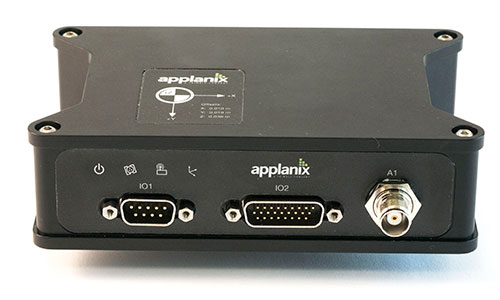
Applanix Corporation has announced the POS AVX 210, the latest addition to its airborne position and orientation portfolio for direct georeferencing of airborne mapping sensors. Using Applanix’ GNSS and inertial technology, the POS AVX 210 enables airborne surveyors to achieve gains in accuracy, efficiency and productivity for low-altitude or small form factor sensors, when compared to GNSS-only point-matching or aerial triangulation techniques.
The announcement was made at the INTERGEO 2015 conference and exhibition in Stuttgart, where Applanix is exhibiting in Hall 8, Booth C8.047.
For photogrammetric applications, the POS AVX 210 delivers highly accurate exterior orientation solutions — reducing the requirement for ground control in assisted aerial triangulation of digital single lens reflex (DSLR) or medium-format photogrammetric imagery. For low-altitude lidar applications, the POS AVX 210 provides the required precision and accuracy of direct georeferencing to enable users to generate point clouds for further refinement in adjustment software.
The POS AVX 210 is fully compatible with, and supported by, POSPac MMS, Applanix’ post-mission software for direct georeferencing of airborne mapping sensors. It is also features a seamless integration with the NanoTrack system from Track’Air, a leading commercial flight management system designed for highly efficient survey flight operations. Aircraft equipped with the POS AVX 210 and NanoTrack will be able to fly missions with reduced sidelap between flightlines, and a greatly reduced requirement for ground control points. These benefits can reduce costs and improve the efficiency of both data collection and the production of finished data sets for end users.
“With POS AVX 210, Applanix has answered a need in the marketplace for a small, compact system that enables efficient data gathering from low-cost yet highly effective sensors. These include DSLR and Medium format cameras, low-altitude lidar systems, and other systems,” said Joe Hutton, director of Inertial Technology and Airborne Products at Applanix.
POS AVX 210 consists of a single rugged enclosure containing a precision GNSS receiver and micro-electro-mechanical-system (MEMS) inertial sensors calibrated with the Applanix SmartCal technology, coupled with on-board data logging capability and interfaces for mapping sensors and flight management systems. POSPac MMS, available as an option with POS AVX 210, is a powerful GNSS-inertial processing software package that includes proprietary advanced capabilities such as the Applanix SmartBase virtual reference station, Applanix InFusion algorithms for increased productivity, and CalQC, a suite of data optimization and quality management tools.
“POS AVX 210 builds on the technological foundation of our established POS AV portfolio for large format sensors, and brings into play the innovations developed for our unmanned solutions. This combination of experience and innovation enables us to deliver a package that strikes the optimal balance between price and performance for this segment,” Hutton said.
POS AVX 210 is expected to be available in the first quarter of 2016 through Applanix’ airborne sales channels.
Trimble debuted its new R2 GNSS receiver at Intergeo 2015, held this week in Stuttgart, Germany.
The R2 GNSS receiver is a receiver that works with Trimble handheld devices and iOS, Android or Window mobile handhelds, smartphones and tablets using Bluetooth or USB connectivity. When paired with a mobile device, the receiver adds professional-grade GNSS capabilities for better accuracy. The rugged Trimble R2 provides GIS and survey professionals the flexibility to choose the mobile device, workflows and accuracy they need based on applications.
Trimble R2 GNSS Receiver for Mobile Devices
The Trimble R2 GNSS receiver is compact and portable, weighing 2.4 pounds. With one-button operation and a field swappable battery, the receiver can be pole or vehicle mounted or carried on a backpack. The R2 is a multi-constellation receiver that supports GPS, GLONASS, Galileo, BeiDou and QZSS satellite signals, as well as SBAS.
With a variety of standard and optional correction capabilities, the Trimble R2 can achieve sub-meter to centimeter positioning for a broad range of accuracy requirements. The receiver is an option for the Bring Your Own Device (BYOD) strategy.
“Today’s geospatial professionals require flexible solutions which allow for configuration to meet their specific job requirements,” said Ron Bisio, general manager of Trimble’s Surveying and Geospatial Division. “The Trimble R2’s versatility to support GIS and survey workflows as well as BYOD deployment enables geospatial professionals to collect data using the mobile device, workflow and accuracy they choose.”
Workflows – GIS and Survey Field Software
Designed for both GIS field data collection and survey workflows, the Trimble R2 receiver integrates with Trimble TerraFlex mapping and GIS field software and Trimble Access survey field software.
TerraFlex software is a scalable cloud-based solution for geospatial data collection. By pairing the R2 with a smart device or Trimble handheld running TerraFlex, the solution addresses a wide variety of field requirements, including attribute-rich GIS data collection on consumer and professional devices.
Trimble Access software supports the workflows of everyday surveying tasks such as topographic and control surveys and specialized surveying tasks such as roads, monitoring, tunnels and mines. By pairing the receiver with a Trimble handheld running Trimble Access or TerraFlex field software, the Trimble R2 is a versatile solution that supports the full range of geospatial data collection workflows for both GIS and survey applications.
Flexible Accuracy
The receiver is capable of receiving a broad range of corrections from traditional RTK, VRS networks and SBAS to Trimble RTX correction services via cellular/IP connections or satellite (L-band), the Trimble R2 provides high-accuracy data worldwide.
The R2 GNSS receiver can leverage the entire portfolio of subscription-based Trimble RTX correction services to accommodate a wide range of applications and accuracy requirements. This includes CenterPoint RTX (less than 4 centimeters), RangePoint RTX (less than 50 centimeters), and ViewPoint RTX (less than 1 meter) correction services.
senseFly has published a white paper named “Generating highly accurate 3D data using a senseFly eXom drone” which presents the results of two photogrammetric land surveys of a construction site. The project was completed earlier in September using two senseFly eXom close mapping and inspection drones, and the announcement was made during INTERGEO, held Sept. 15–17 in Stuttgart, Germany.
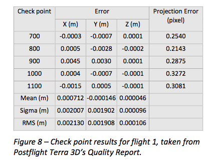
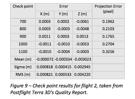
The results demonstrate that 3D point clouds produced with an eXom quadcopter can reach a global precision comparable to that of a total station survey and meet the typical accuracy requirements of construction projects, according to a news release from senseFly.
The first eXom survey (figure 8) achieved 2.1 millimeter accuracy in X, 1.9 millimeter in Y and 0.1 millimeter in Z (RMSE). The second eXom survey (figure 9) achieved 0.8 millimeter (X), 0.5 millimeter (Y) and 4.2 millimeter (Z).
“This degree of absolute accuracy from a drone is unparalleled and positions the eXom as a surveying instrument that is comparable in performance to standard total stations,” said Andrea Halter, senseFly’s co-founder. “These results were due, in part, to the high 38 MP resolution and sharpness of the flight’s images, captured by the main camera inside eXom’s TripleView head. Add to this image quality the ability to operate close to the terrain and the introduction of highly precise ground controls and you have a recipe for exceptionally accurate 3D data.”
Two eXom drones flew separate survey missions at an altitude of 14 meters above the site, achieving an average ground sampling distance (GSD) of 2.2 millimeters, senseFly says. All the flights were completed using the drone’s Interactive ScreenFly flight mode, whereby the UAV (unmanned aerial vehicle) is controlled using a handheld ScreenFly controller connected to senseFly’s eMotion X flight planning and control software.
This flight mode’s “cruise control” feature, combined with its auto-trigger function, enabled each of the eXom drones to survey the 1,100-square-meter site in a single flight. Meanwhile, the live on-screen feedback from the drone’s five different navcams and ultrasonic proximity sensors helped the operator ensure that no contact was made with either the on-site crane or any the trees surrounding the complex site, senseFly says.
“This project’s flights took place at 14 meters above the ground, but with the eXom’s Distance Lock feature we are able to safely fly just 4 meters away, so it isn’t unrealistic to think that the accuracy we achieved could be improved still further.”
To download the eXom accuracy white paper click here.
Azuga’s Fleet Driver Rewards App Wins CTIA E-Tech Award
Ananth Rani founded Azuga in 2013.
When Ananth Rani began work in 2012 on the Fleet Driver Rewards app that has made connected vehicle provider Azuga a CTIA up-and-comer, he wasn’t sure he was making the right decision.
“Frankly, it was a bit of an experience to see if there was still room in the market for another vendor,” he said recently as he took time to sit-down at a coffee shop in Las Vegas’ Sands Expo Center amid CTIA Super Mobility 2015. “I thought, ‘What the hell am I getting myself into?’”
The gamble paid off for the Azuga and its dedicated co-founder. Azuga’s app took home second place in the Mobile Cloud division at the CTIA E-Tech Awards Thursday. The honors go to what CTIA describes as “the most innovative emerging mobile services, solutions and technology from areas such as the cloud, network equipment, M2M and the Internet of Things.”
What makes Azuga’s app innovative says Rani, is that it appeals to a unique user: The fleet driver.
Not just managers. Not just owners. The drivers themselves.
“Azuga is all about social telematics,” he says. “It comes from the heart. I tell fleet managers, ‘Do you want to be remembered as a gotcha guy or an attaboy?’”
A Silicon Valley veteran, Rani utilized a principal more likely to be seen in apps marketed to consumers: gamification. Fleet drivers earn points based on things like hard-braking, acceleration, sustained high speeds and driving in adverse weather conditions, among other metrics determined by a Ph.D. in statistics that Azuga has on staff.
“The expectation was that a driver will naturally move toward a safer fleet by competing with the rest of the drivers, and that as the risk goes down the miles per gallon goes up,” Rani said, “and that’s your ROI.”
The reward for winning is no simple badge: Drivers’ profiles are pulled from LinkedIn and their rankings are visible among the “Azuga Awesome Drivers” group on the social network. Rani says Azuga is “not J.D. Power” but aspires to have the same reputation for determining safe drivers.
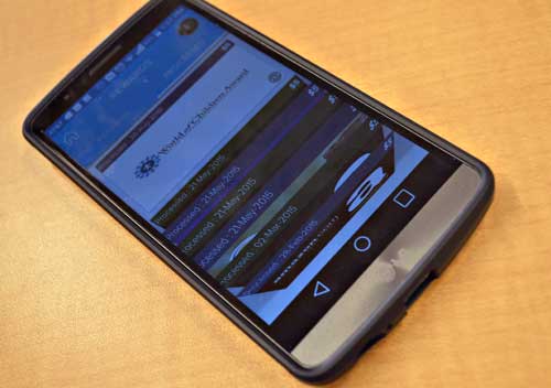
Azuga Fleet Driver Rewards can gift a reward as a donation to groups like World of Children.
There’s also cash on the line. The company gives out quarterly prizes to the Top 10 drivers and Top 10 fleet managers of the 50,000 nationwide users, and the 1,000+ corporate customers can then also choose to award their drivers based on their own goals through an electronic gift card program that is tied to 14 national brands, including Amazon, Wal-Mart, Home Depot and Burger King. The driver sees the amount awarded and then has the choice of gift cards. Azuga has also recently added three charities to which the drivers can pass the reward as a donation.
Safety and savings aside, employee retention is an additional
“This is a blue collar world where the employee takes the truck home at night. Feeling engaged is the key to employee retention in a world where they may never see the boss and where they only see their manager for a meeting every few weeks.”
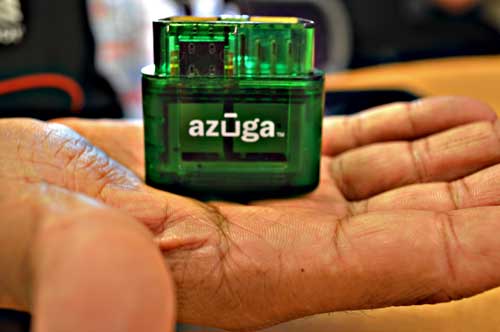
Azuga’s OBD-II connector is manufactured by parent company Danlaw Inc.
Azuga pairs with hardware manufactured by its parent company, Michigan-based Danlaw Inc. Rani sees the relationship as one that benefits Azuga with the “automotive grade DNA” and calls it “Silicon Valley meets Detroit.”
Azuga Fleet costs 69 cents per day per vehicle, and customers are companies of varying sizes with Aaron’s, the rental furniture and home appliances chain, using it for 3,000 trucks and 6,000 drivers on the large end and single-driver landscape companies at the small end.
Growth plans for the app including functions to help drivers find parking, locate a parked truck and easily message clients that they are on their way. The app is also being reviewed by state governments as a tool to determine whose cars need to be emissions-tested and to track hours required for state graduated driver licensing.
It’s currently being tested by the Oregon Department of Transportation as a way to assign a road usage charge that funds highway repairs. The topic is politically divisive, with opponents saying replacing the gas tax with a per-mile fee is inequitable and subsidizes gas-guzzlers and advocates saying it will lead to safer roads and is an easier, faster alternative to tolls. The din doesn’t concern Rani. He says the intent is the same that inspired the fleet management app.
Septentrio this week is launching two successors to its APS-U: The AsteRx-U and the AsteRx-U Marine multi-constellation dual-antenna receivers. The AsteRx-U will be presented to the public for the first time at two trade shows this week. ION GNSS+ takes place Sept.14-18 in Tampa, Fla., and INTERGEO 2015 will be held in Stuttgart, Germany, Sept. 14-18.
The AsteRx-U and the AsteRx-U Marine incorporate the latest GNSS tracking and positioning algorithms and interference mitigation. Machine-control users in the agricultural and construction industries, as well as users in marine and mining industries, benefit from a complete system with integrated UHF radio, Wi-Fi, USB, Bluetooth and cellular connectivity and a spectrum analyzer, Septentrio said. All configurations can be done via the on-board web interface.
The AsteRx-U and AsteRx-U Marine feature a full range of positioning techniques and algorithms to ensure that users have the highest accuracy and reliability. The spectrum analyzer enables users to visualize the RF spectrum. Based on its extensive experience with real-life interference sources and their mitigation, Septentrio has developed interference mitigation technology that automatically counteracts various kinds of ambient intentional and unintentional RF interference.
The AsteRx-U family of receivers is built around Septentrio’s latest ASIC, GReCo4, which was introduced in 2014. It incorporates built-in jamming detection and countermeasures, multi-path rejection, fast acquisition and other advanced features. Both receivers have more than 500 hardware channels to track all available constellations (GPS, GLONASS, Galileo, Beidou, IRNSS and QZSS) and feature many algorithms: LOCK+ technology to maintain tracking during heavy vibration machine use and IONO+ technology to assure the accuracy of the position even in regions of elevated ionospheric activity.
The AsteRx-U has decimeter- and centimeter-level RTK positioning including TerraStar. The AsteRx-U Marine also supports Veripos PPP augmentation services. It includes extra anti-jamming technology to counter Iridium and INMARSAT-uplink interference, as well as an extra antenna connector for a dedicated L-band antenna to optimize L-band reception at high latitudes.
Straightforward to set up and integrate with existing systems, the AsteRx-U and AsteRx-U Marine use any device with a web browser to facilitate usability and configuration for the user.
“We want to make it easy for our customers to use high-accuracy positioning in their work,” said Jan Leyssens, Septentrio product manager. “Using the integrated communication functionality in the compact and portable AsteRx-U, users won’t have to worry about adding their own modems or UHF radios to get access to corrections.”
Leyssens continued, “The receiver web interface is available wirelessly on any mobile device. It was designed together with several of our key customers, resulting in an interface that is not only easy to use by field operators, but also provides many useful troubleshooting tools, such as the spectrum analyzer, to solve problems in the field and minimize downtime.”
Septentrio will be at Booth 318 at ION GNSS+, and at Hall: 4, Booth: D4.014, at INTERGEO.