The Coperinicus Masters Cup Photo: Anwendungszentrum GmbH
Copernicus Masters submissions of ideas, applications or business concepts involving innovative uses of Earth observation data are due by July 13. Along with cash prizes, the winners will gain access to an international network, corresponding data, start-up funding and other support valued at more than €300,000 ($322,444) total.
The amount of data produced by Copernicus, the European Earth observation program, and its Sentinel satellites opens the door to products and applications in a wide array of business sectors. The European Space Agency (ESA) and Anwendungszentrum GmbH Oberpfaffenhofen (AZO) have thus initiated the Copernicus Masters competition to aid visionary entrepreneurs in bringing their innovations to market.
“Start-ups and SMEs in particular stand to benefit from the virtually limitless scope of the data Copernicus provides,” said Prof Dr Volker Liebig, director of Earth observation programs and head of the European Space Research Institute (ESRIN), ESA. “The ideas submitted to previous editions of the Copernicus Masters have already demonstrated this to impressive effect, as has the constantly growing number of companies that are developing products and services based on Earth observation data in ESA’s business incubation program.”
These companies operate in a diverse range of fields, where they address subjects such as resource efficiency in agriculture, construction and renewable energy. The Copernicus Masters also is looking for new services and products in forward-thinking segments such as big data, cloud computing, crowdsourcing, data visualisation and mobile applications, to name a few.
In this year’s edition, prizes will be awarded in topic-specific challenges sponsored by partners, including: ESA, the German Aerospace Center (DLR), T-Systems International GmbH, Satellite Applications Catapult Ltd., Greece’s National Cadastre and Mapping Agency (NCMA), CloudEO AG and European Space Imaging GmbH. The new University Challenge specifically addresses students and research assistants around the world.
“We and our partners are offering the participants space for innovation in areas that are already shaping the future — the Internet of Things (IoT), Industry 4.0, smart cities and renewable energy, for example,” said Thorsten Rudolph, AZO managing director. “We want to support them in realising their creative solutions to these global challenges.”
Research and industry experts will select the winner of each challenge. The overall winner and 2015 Copernicus Master will receive, along with their challenge prize, €20,000 ($21,478) in cash and a satellite data package worth a further €60,000 ($64,434), which is being provided with the financial support of the European Commission.
“Taking part in the Copernicus Masters gave us the chance to make some key contacts and gather valuable feedback,” said John Smedegaard, a co-founder of Ceptu, which won the CloudEO Farming Challenge in 2014. “The whole process was a huge help in advancing our idea and developing it into a commercial product through our new start-up.”
All of the winners will be announced this fall and recognized at an awards ceremony.
For details on this year’s prizes, partners and terms of participation, view the event website.
On Wednesday, the GPS Directorate said further data analysis shows that a technical error affecting some Boeing GPS IIF satellites first appeared in 2011, two years earlier than originally stated, according to a Reuters report.
The error first appeared one year after the GPS IIF satellites became operational. The error affects the way the ground control system builds and uploads messages transmitted by the satellites, but does not affect the accuracy of GPS signals. It involves the ground-based software used to index messages.
Lockheed Martin runs the GPS ground control segment, which enables Air Force officials to operate all GPS satellites, including the IIF satellites built by Boeing.
The U.S. Air Force plans to award multiple contracts for companies to demonstrate their ability to build GPS III satellites, according to a report by Mike Gruss of Space News.
The Air Force expects to award the contracts — worth up to $6 million — during this calendar year. Lockheed Martin Space Systems of Denver is the current GPS III satellite contractor, building the first eight GPS III satellites. The first satellite is expected to launch in 2017.
Traqueur, a French-based company in the field of advanced telematics, has introduced Nano, an autonomous mobile beacon for the protection of property and objects designed to optimize the potential of the Sigfox network.
Nano uses radio and GPS to track indoor and outdoor location, has a battery life of three to five years and is named Nano for its compactness.
In June 2014, Traqueur formed a strategic technical partnership with Sigfox, the sole operator of the global cellular network for the Internet of Things (IoT) and machine-to-machine communications.
Nano displays functionalities of UHF direction finding, providing the ability to locate buried and hidden objects. It also has a high-sensitivity GPS module and an integrated antenna to transmit its position through the Sigfox network when the beacon moves.
Nano’s roaming features open up prospects for international marketing.
The development of Nano has received support from BPI Ile-de-France (Paris region).
“Certified Sigfox Ready and provided with mixed UHF/GPS technology, the Nano beacon means that we can offer the widest range of technology solutions of the track and trace type on the market and can address new segments including merchandise and logistics, for example,” said Marc Verdet, CEO of Traqueur. “We are also accelerating our international development through distribution partnerships in every country with a SIGFOX network infrastructure.”
“The development of this new beacon by Tracker, based on our network, is extremely innovative and shows the limitless scope for innovation that SIGFOX technology allows, “Stuart Lodge, Executive Vice President Global Sales at SIGFOX. “This technology gives by far the longest battery life on the market, a decisive advantage for applications such as the location of property. The solution developed byTraqueur, because it is very demanding, confirms the legitimacy of our technology wherever the SIGFOX network is deployed.”
DiscoverTraqueur in forthcoming trade shows in France:
· Flotte Auto meeting, March 19, 2015 – Palais Brongniart – Paris Stand B07
· DLR Congress, March 26 & 27, 2015 – CNIT Paris – Stand 44
· MtoM & Connected Objects show on April 1 & 2 – CNIT Paris – Stand E7 Conference: Innovation in value-added services around the IoT. Tracker Nano presentation workshop.
· Intermat from April 20 to 25, 2015 – Paris -Nord Villepinte – Booth 6B022
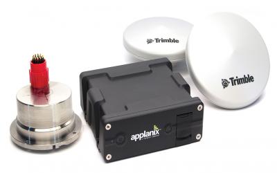
Applanix has introduced an expanded portfolio of marine georeferencing and motion compensation solutions. Taking advantage of Applanix proprietary technology, the new line-up of marine products offers high-performance solutions to a broader cross-section of the hydrographic survey industry.
All Applanix Marine products benefit from the optimal integration of GNSS and inertial observables, with access to Trimble GNSS technology for performance advantages.
The Applanix POS MV Surfmaster.
The announcement was made at Ocean Business 2015, an exhibition of more than 300 of the world’s leading manufacturers and service providers in the industry.
“Advances in Applanix inertial technology enable us to offer the high performance levels we are known for at even more attractive price points. By introducing this new product portfolio, we are able to deliver solutions suited to all types of bathymetric mapping,” said Peter Stewart, director of Marine Products. “This revised product lineup demonstrates Applanix’ continued commitment to provide customers with options that best fit their budget and requirements.”
At the entry level of the expanded product portfolio, Applanix introduced the new POS MV SurfMaster. Incorporating Applanix’s proprietary SmartCal inertial calibration techniques, POS MV SurfMaster delivers robust georeferencing for small platforms, both manned and unmanned. SurfMaster is fully supported by Applanix’ post-processing software POSPac MMS, and can deliver roll and pitch accuracy to 0.03 degrees, regardless of latitude or rate of vessel motion.
Applanix’ new marine product lineup also includes POS MV WaveMaster II and POS MV OceanMaster. Using newly developed inertial technology, POS MV WaveMaster II delivers performance equal to the well-established and proven WaveMaster E, but at a new lower price point. POS MV OceanMaster replaces the POS MV 320 E as the georeferencing and motion compensation solution of choice for the hydrographic professional, integrating next generation inertial sensors, which enable performance and pricing previously unavailable with this class of technology. POS MV OceanMaster provides reliable and robust surveying in even the most demanding sea conditions. POS MV Elite remains the ultimate option for users seeking the highest level of performance available to the industry.
The new POS MV SurfMaster, POS MV WaveMaster II and the POS MV OceanMaster are available now worldwide through the Applanix sales channel.
Airbus Defence and Space has launched its WorldDEM Digital Terrain Model (DTM), a highly accurate standardized representation of bare Earth elevation that can be made available for any point on the globe. This addition completes the WorldDEM portfolio, enabling Airbus Defence and Space to provide both surface and terrain elevation information in support of global customer projects.
WorldDEM DTM can be delivered for more than 90 Million km² of the Earth’s landmass.
The WorldDEM DTM is derived from the WorldDEM product (Digital Surface Model) by removing all man-made features and vegetation. The quality of the original WorldDEM product combined with a sophisticated editing process guarantees highly precise and consistent terrain information, Airbus said. While surface features (such as built-up areas and vegetation) are reliably removed, characteristic terrain features such as ridge lines or mountain crests are preserved.
The WorldDEM DTM provides an excellent foundation layer for a wide range of applications such as civil engineering (road design, earthwork calculation), the management of natural resources (such as flood modeling), mapping (such as derivation of contour lines) as well as military mission planning (vehicle trafficability analysis, 3D terrain visualization).
WorldDEM is based on data acquired by the high-resolution radar satellites TerraSAR-X and TanDEM-X, which started synchronous data acquisition in December 2010 and completed coverage of the Earth’s entire landmass twice over in mid-2013. The satellites covered more complex terrain areas with a third and fourth acquisition campaign to ensure consistent high quality and accuracy of the final product. WorldDEM provides the first global, single-source, high-precision Digital Surface Model and has established a new standard of global elevation models.
The Remus 600 Unmanned Underwater Vehicle, made by Kongsberg Maritime, a Norwegian company.
The U.S. Navy plans to deploy its first underwater drones from submarines later this year, according to a report by Military.com.
The website quoted Rear Adm. Joseph Tofalo, the Navy’s director of undersea warfare, who said the deployment will include the use of the Remus 600 Unmanned Underwater Vehicles (UUVs) to perform undersea missions around the globe.
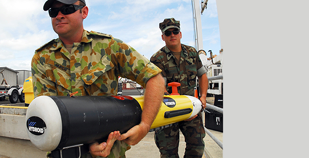
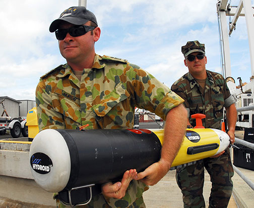
Sailors carry a Remote Environmental Measuring Unit (REMUS) 100. (Credit: U.S. Navy)
“Now you are talking about a submarine CO who can essentially be in two places at the same time — with a UUV out deployed which can do dull, dirty and dangerous type missions. This allows the submarine to be doing something else at the same time,” Tofalo said. “UUVs can help us better meet our combatant command demand signal. Right now, we only meet about two-thirds of our combatant commanders’ demand signals, and having unmanned systems is a huge force multiplier.”
The Remus 600 is a 500-pound, 3.25-meter-long UUV equipped with GPS, as well as dual-frequency side-scanning sonar technology, synthetic aperture sonar, acoustic imaging, and video cameras manufactured by Hyrdoid, a subsidiary of Kongsberg Maritime. The Remus 600 is similar to Bluefin Robotics UUVs, which were used to search for wreckage of missing Malaysia Airlines flight MH370. Other applications include hydrographic surveys, harbor security, and environmental monitoring.
In this video, Explosive Ordnance Disposal Mobile Unit One (EODMU-1) tests the Remus 600 to locate mines using autonomous guidance and advanced sonar.
The Association for Unmanned Vehicle Systems International (AUVSI) will host Unmanned Systems 2015, which will run from May 4-7 at the Georgia World Congress Center Atlanta. With 8,000 attendees from around the world, Unmanned Systems 2015 is the largest expo and trade show in the industry, according to AUVSI.
The event will include three days of interactive exhibits and exciting demonstrations of air and ground vehicles spread throughout 350,000 square feet of exhibit space. The 150-plus educational sessions, workshops, and panel presentations will focus on the future of commercial, humanitarian, environmental, governmental, and military applications for robotics and unmanned systems. For more information on the sessions, see AUVSI’s Program Planner.
This year’s conference will feature keynote addresses and panel discussions by:
Colin Guinn, chief robotics officer, 3D Robotics
Dave Vos, project lead, Project Wing @ GoogleX
David Vigilante, senior vice president, legal, CNN
Helen Greiner, CEO, CyPhy Works
Hugh Herr, MIT professor and head of biomechatroinics at the MIT Media Lab
Rep. Frank Lobiondo, New Jersey House of Representatives
Henrik I. Christensen, distinguished professor, KUKA chair of Robotics, and director of the Robotics & Intelligent Machines Center, Georgia Tech
For more information and a full agenda of events, visit www.auvsishow.org.
Screenshot of the Tennessee Law Enforcement Facility Mapping Challenge showing the more than 440 edited points (green dots). At this scale, many dots contain more than one edited or verified structure.
Volunteer mappers continue to make contributions to ability of the U.S. Geological Survey (USGS) to provide accurate mapping information to the public. Recently, volunteers were asked to update all of the law enforcement structure points in Tennessee. The volunteers answered the call and added, verified, edited or deleted 440 points.
All of the points were quality checked by either a peer reviewer or an advanced editor, so the data was ready to go into the National Geospatial Program’s web-based The National Map at the conclusion of the USGS Mapping Challenge.
The volunteer additions and edits will be symbolized on US Topo maps during the next production cycle for Tennessee, slated for 2016.
Mapping Challenges, conducted by the National Map Corps, ask volunteers to concentrate on specific areas and structure types that need updating. They encourage volunteers to remain engaged and incentivize participation. Once a need is determined, a call to action goes out to the volunteer corps with information on the geographic location and the type of structures that need updating. Volunteers who participate can earn a series of virtual recognition badges and are recognized on social media and the Map Corps project site.
Using crowd-sourcing techniques, the National Map Corps encourages volunteers to collect manmade structures data in an effort to provide accurate and authoritative spatial map data for The National Map. Structures being updated include schools, hospitals, post offices, police stations and other important public buildings.
“At times, locating structures seems similar to solving puzzles or detective work,” commented fconely, a Challenge veteran and one of the project’s more active participants.
Dude Solutions Inc., a software-as-a-service (SaaS) provider of operations management solutions, has acquired Mobile311, a GIS and mobile mapping solution provider. Terms of the transaction were not disclosed.
The Mobile311 acquisition allows Dude Solutions to address the growing requirements of state and local governments, particularly those with public works needs, as well as universities and other entities that manage spatial and distributed assets, Dude Solutions said. Dude Solutions will now offer a comprehensive web-based and mobile operations solution that enables these organizations to more effectively manage both their facilities as well as assets at-large.
“Mobile311 has built a powerful, patent-pending GIS and mobile application that aids in spatial and linear asset management — along with a growing client base,” said Kent Hudson, CEO of Dude Solutions, Inc. “Previously, spatial asset management software has been reserved for the largest cities and counties and, with this acquisition, Dude Solutions is democratizing GIS technology for any size local government client as it has with cloud-based facility management solutions.”
Dude Solutions will offer Mobile311 GIS tools that extend the power of Dude Solutions’ offerings into clients’ spatial asset management programs. Mobile311 clients will have access to Dude Solutions’ innovations and product delivery and support. The platform allows mobile workers to access work orders and other critical geographic data in the field while giving supervisors additional reporting and analytical insights for increased efficiency.
“There is a growing movement to utilize the power of mobile to better manage the complexities of operational asset management. With this acquisition, together we can provide the very best mobile GIS and mapping product in the market combined with Dude Solutions world-class delivery and support,” said Chuck Wright, president of Mobile311. “Building on our collective knowledge base of the operational must-haves for success, the combined organization will be a powerhouse in the marketplace.”
Mobile311 is Dude Solutions’ second acquisition since it announced a growth investment of up to $100 million from Warburg Pincus, a global private equity firm focused on growth investing, in February 2014. The Mobile311 team has joined Dude Solutions and will now operate from Dude Solutions’ headquarters in Cary, N.C. In March, Dude Solutions acquired Windmill Software.
The world of indoor location continues to evolve, with a number of variations on when and under what circumstances you might be able to wander around your local mall getting directions to your favorite ice-cream store on your iPhone. Some malls are mapped, some are not, some (most) have Wi-Fi hot-spots and Bluetooth beacons, some may be in areas where outdoor directional beacon are being tested and their signals penetrate indoors. But the thing they have in common is that most seem to lose GPS/GNSS signals once you get a few tens of meters away from the front entrance.
Some companies have managed to make indoor location in your mall work with a combination of GPS, plus all the RF signals that can be received, plus using inertial and/or magnetic sensors in your mobile phone, and sometimes also with detailed indoor map-matching — but no-one seems to do this in a simple, consistent, reproducible way for any store wanting to ensure you arrive at their door, or for a telecommunication industry wishing to standardize how it works for E911 and then field it everywhere.
So I’ve actually been looking for an indoor location outfit who might have found a consistent solution that can work from place to place — by that I mean from mall to mall, city to city, country to country, even continent to continent, and every time after first set-up — and I suspect that I may have now found one.
The team at iPosi in Denver is still working on their solution, but they have run some pretty convincing demonstrations in some very challenging locations, so they may have found an inside edge that could take them many places (sorry, about that pun).
While iPosi’s headquarters are is in Denver, the company also has labs in Boulder and offices in Dallas. It hasn’t been around too long — since 2011 — but it has been busy filing patents for the key technologies that drive their location technology. Of 40 total patents in the pipeline, five have been granted or allowed, 15 are pending, and 20 more are in development. With only six employees, iPosi is a small outfit, but it also gets design assistance from a European design center for other GNSS signal designs.
One of the key GNSS elements the iPosi team has going for them is an in-house developed GPS receiver with a sensitivity of -175 dBm. If you could get any sort of a signal deep inside a building, it’s possible that they might be able to receive it. But, for sure, anything you would receive deep inside would be just multipath – right? There are other pieces to this story however.
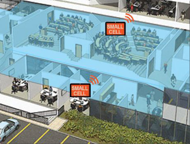
The iPosi system design is based on mobile phone “small-cell” installations. The world now has around 100 million multi-floor buildings with an average of eight floors each, and most buildings present some level of attenuation for external mobile phone cell-tower signals — never mind GPS signals. Most of us should be familiar with having to leave meetings to get “bars.” holding the phone up against a window, walking around to catch reflected indoor signals, and eventually having to leave the building and be with a group of other people who are doing the same thing – looking for a clear cell-phone signal to make a call. In the Northern U.S. and Canada in the winter, this can even be hazardous to your health!
So small cells behave as basically indoor “repeaters” of mobile phone signals. iPosi believes that an average of four of these repeaters are needed to broadcast sufficient signal on each average building floor. So iPosi embeds each small cell with one of its high-sensitivity receivers. Once positioned indoors, and over time, the receivers self-locate inside the building. Currently, installation of small cells can be somewhat cumbersome and time consuming, but non-GPS small cells can be located during installation using traditional indoor surveying techniques — such as laser-based measurements. Either that, or no measurements are made at all, and no device location information is associated with a device.
Small-cell setup.
With each small cell equipped with a high-sensitivity receiver — with especially clever algorithms to differentiate and interpret multipath over time — each device goes to work transmitting repeater mobile-phone signals and eventually self-locates. Contained within these signals are each small-cell location, plus a timing message that allows any standards-compliant handset to calculate range to each transmitter and to perform an OTDOA (Observed Time Difference Of Arrival) position fix.
If the small-cell location at install is also fed into the GIS database for the building and, more importantly, for the local area, the E911 “dispatchable address” for that building has GPS-level accuracy. And first responders will also have numerous other small-cell location aids within the building.
Another detail is that the iPosi receiver uses A-GNSS (including ephemeris) data, so it only needs small snapshots of signal to deduce position. This means very low power consumption for positioning at the small cell, which is good because small cells are mostly battery powered.
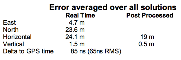
So, does it work? In FCC E911 demonstrations at the Omni Hotel in San Francisco, iPosi consistently located to within 50 meters horizontally and a few meters vertically.
Masonry, turn-of-20th-century construction
Approximately 15 floors, similar to surrounding
Test site: ninth floor hotel room
Horizontal error = 38 m, Vertical error = 9.5 m
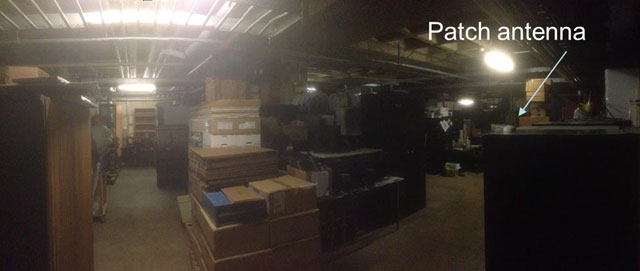
There were several other tests in representative converted apartments, a modern four-story steel and concrete building, and inside a university auditorium. But the one that really caught my attention was the test iPosi ran in the basement of an engineering center.
Engineering center, lower basement 3.5 m below grade.
That’s 3.5 meters below grade! The iPosi receiver measurement system was able to determine that some of the signals were actually received directly from a GPS satellite — unbelievable! That’s through concrete and stone down to 3.5 meters below grade with a simple patch antenna!
Most of your average mall locations are not as location-hazardous as this basement test. Its possible that finding your way to the closest indoor ice-cream store could soon be child’s play, which will be especially helpful for the kids with smartphones.
iPosi is working with some of the key equipment suppliers in the industry. It’s quite likely that some of its evaluation sites could soon evolve into operational indoor location facilities. And iPosi’s argument is that its indoor location solution is truly scalable or can be readily standardized — as the telecom companies apparently would love for all indoor location technology to be — so the iPosi solution can readily transition across borders and countries, and roll out could be greatly simplified.
Tony Murfin
Hard to say if this will be the winning indoor location solution, but in the end the market will decide if it really is a scalable, simple solution, and if it will succeed — right?
COLORADO SPRINGS, Colo. — I had the pleasure of having an early breakfast on this beautiful Colorado morning with Mark Stewart, VP and program manager at Lockheed Martin in Denver for the GPS III program. Mark was very upbeat, a normal state for him actually, and stated that GPS III SV1 was fully integrated — payload, bus and propulsion segments — on April 7, and “all is proceeding according to plan.”
“SV1 is ready to begin environmental testing at the vehicle level and there are no liens going forward,” Mark said. “There are no current issues or concerns.”
Currently, the schedule calls for SV1, per Space and Missile Systems Center (SMC) mandate (read that as Lt. Gen. Sam Greaves) to process through acoustic testing to simulate the acoustics of launch and early orbit maneuvers. Then the complete vehicle will endure a rigorous thermal vacuum testing procedure that should be completed by this summer (2015).
Barring any major anomalies, I am still predicting that SV1 will be through tests by the end of this calendar year. That is not a LMCO prediction as much as it is mine. With that schedule intact, SV1 should be ready for launch by the first quarter of the calendar year 2016. Great news. I will have photos of the mated segments, which make up GPS III SV1, as soon as they are cleared for release. More later.