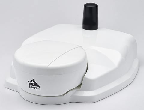
NovAtel’s SMART6-L attaches to the Relay RTK radio module to create a single unit for easy system integration.
NovAtel Inc. has launched the Relay RTK radio module, a docking station that provides radio connectivity for its SMART6-L L-band capable GNSS receiver.
The Relay RTK module combined with NovAtel’s SMART6-L receiver creates a compact, easy to integrate positioning solution, NovAtel said. It is available in four radio versions: 400 MHz UHF licensed band; 900 MHz UHF unlicensed band; HSPA (3G) cellular; and CDMA (1xRTT/EV-DO) cellular. The CDMA version is approved for use on the Verizon cellular network.
The 400 MHz and 900 MHz versions support both base and rover configurations. The base station is configured via the integrated web-server/Wi-Fi access point using the web browser on any compatible personal computer, tablet or smartphone. The cellular radio versions support the reception of NTRIP and RTK corrections over the cellular network.
SMART6-L customers can connect to the Relay using their existing SMART6-L interface cables. Relay has support for both screw and magnetic mounting; optional mounting plates are available for roof and pole mounting. NovAtel’s SMART6-L with Relay provides the same level of performance as a standalone SMART6-L unit with the added convenience of radio connectivity to support RTK and NTRIP corrections.
A new report by Visiongainexamines geospatial data analysis for defense and homeland security — a world market worth $9.7 billion in 2014. The report, “Governmental Geospatial Intelligence (GEOINT) Solutions Market 2014-2024: Digital Mapping, Geographic Information Systems (GIS), Cloud-Based Geo-Analytics & Geo-Data Exploitation for Defence & Homeland Security” is being offered by Reportbuyer.com.
Advances in technologies such as cloud and 3D modeling — together with increased availability of high-quality, high-accuracy geospatial data, especially from space-based remote sensing satellites — are propelling the market for governmental GEOINT solutions, Reportbuyer.com said.
“The coming decade will see governments around the world scrambling to acquire GEOINT capabilities on increasingly higher scales, to ensure they stay on top in the ‘information superiority’ race,” Reportbuyer.com said in a press release. “At the moment, outside the U.S. this is a relatively young market, at the very beginning of a period of large international expansion over the next ten years.”
According to Reportbuyer.com, geospatial information exploitation technology is one of the vital enablers and defining aspects of 21st century defense, intelligence and homeland security capabilities and operations. In a digital age where the vast majority of data has a location and time, GIS and GEOINT systems provide the means to reference it geographically.
“In this visual context, complex dynamics, patterns and relationships can be revealed, analyzed and understood in a completely new way,” Reportbuyer.com said. “This takes ‘situational awareness’ to an entirely different level, and enables an unprecedented and powerful new type of analysis: geospatial analysis. A key part of this overall capability is a new generation of tools for advanced digital mapping and modeling, which extend the applications of GIS beyond intelligence, C2 (command and control) and the achievement of information superiority into areas like resource management, mission simulation, and down to individual soldiers.”
The 300-page report provides market forecasts and analysis for GEOINT solutions, 2014-2024, and sales value projections of the market with essential information on the technologies, GEOINT organizations and competitors. The report is available at Reportbuyer.com.
The NGP provides leadership for USGS geospatial coordination, production and service activities. It engages partners to develop standards and produce consistent and accurate data through its National Map Liaisons. Operational support is provided by the National Geospatial Technical Operations Center. These and other NGP activities that are essential to the National Spatial Data Infrastructure (NSDI) are managed as a unified portfolio that benefits geospatial information users throughout the nation.
Tischler’s accomplishments include managing the research for a $30 million broad-based research portfolio with both domestic and international applications. He has held a number of positions, from a research scientist collecting, analyzing, and processing geospatial data, to acting technical director, responsible for strategic planning and program implementation for a diverse portfolio of geospatial research projects.
In his most recent role as associate technical director, he defined cutting-edge research projects that affect the direction of geospatial science and how geospatial data is used throughout the U.S. Army, the USGS said.
“We are excited to have Mike to be part of the USGS mapping and geospatial community,” said Kevin Gallagher, associate director for Core Science Systems. “Mike has the background, insight, and energy to move the Program boldly into the future while still respecting the agency’s legacy for mapping excellence.”
“Being selected to direct the National Geospatial Program is a tremendous honor, and I am both proud and humbled to join the USGS family in this role,” said Tischler. “The valuable services provided by this program are made possible by a dedicated team across the country, of which I am truly privileged to be part.”
“The NGP has the responsibility to provide accurate, accessible, available, and authoritative geospatial data to the public and key partners while continually leveraging and adapting to evolving technologies,” Tischler continued. “I am thrilled to have the opportunity to work toward these goals alongside the talented, devoted NGP team and its partners, while engaging with the mapping community to both lead and shape the future direction of the program.”
Tischler holds a master of science in soil and water science and a bachelor of science in soil science and is currently a Ph.D. candidate in Earth systems and geoinformation sciences at George Mason University.
“I would also like to thank Pam Haverland for serving as the acting director for the National Geospatial Program,” Gallagher said. “Over the past six months, Pam has provided caring and visionary leadership all while completing the SES Candidate Development Program and working in the USGS Budget Office as required, at the same time. She will be sorely missed!”
Jim Williams, manager for the Federal Aviation Administration’s Unmanned Aircraft Systems (UAS) office, will be the keynote speaker at the MAPPS National Surveying, Mapping and Geospatial Conference, scheduled for April 13-16 in Crystal City (Arlington),Va.
Williams will speak at a luncheon on April 14. He’ll address the recently published notice of proposed rulemaking issued by his office in FAA, including regulations and policies that will affect surveying and mapping firms that want to fly unmanned aerial vehicles (UAV) and UAS in the commercial market.
“MAPPS has worked with Mr. Williams and his staff for several years to assure that business and societal benefits of using UAV/UAS for aerial surveying, mapping and imagery are recognized and empowered in FAA policy,” said John Palatiello, MAPPS executive director. “UAV/UAS technology is the future of the mapping, surveying and geospatial profession. It is imperative that geospatial firms have the ability to operate UAV/UAS. Mr. Williams understands this, and his office’s policies have reflected his understanding of our community as an important stakeholder.”
“We’re honored to have Mr. Williams join us at the conference. We look forward to hearing how he sees the future of UAV/UAS and how it will effect the business and professional practice of surveying and mapping,” said Curtis Sumner, National Society of Professional Surveyors (NSPS) executive director. “His addition to the conference strengthens an already outstanding program.”
Full registration for the conference is required for admission to the keynote luncheon.
GIS map provider Mapmechanics has boosted the number of African countries for which it offers HERE vector (scalable) map data.
HERE mapping from Mapmechanics consists of street-level vector map and includes major highways, main roads and also some minor roads and city streets, and is useful for route planning, drive-time analysis, vehicle tracking and geo-demographics. A key feature of the data is that its structure is consistent across many countries, enabling users to adopt the same analytical and display strategies from one country to another.
The new African countries added to the Mapmechanics portfolio are Cameroon, Cape Verde, Central African Republic, Chad, Democratic Republic of the Congo, Equatorial Guinea, Ethiopia, Gabon, Guinea-Bissau, Republic of the Congo, São Tome and Principe.
Because it is in a standard and widely recognized format, the mapping lends itself well to use with other data such as traffic speed and density where this is available. It can also be used for techniques such as reverse geocoding (finding a location by its coordinates).
The mapping also enables users to add a sense of place to activities such as geo-demographic studies, store location analysis, leaflet distribution territories or depot management, and ensures that users can overlay just the features they need on shaded maps.
Mapmechanics already offers HERE mapping for many of the more prominent African countries, including for instance Botswana, Egypt, Kenya, Mozambique, South Africa and Tunisia. Altogether around two dozen African countries are now covered, and more will be added in future.
HERE mapping is just one of a wide range of mapping products offered by Mapmechanics for the UK and the world, all of which can be obtained directly from the company or through its transactional website.
Navitel Q1 2015 Maps for Brazil, Mexico, Maldives, Philippines
Navitel has updated Q1 2015 Navitel Navigator maps of Brazil, Mexico, Maldives and the Philippines.
The updated maps contain 1,892,294 kilometers of roads, 2,381,245 points of interest (POI) and 264,896 settlements. Users can now search by a road network for 7,370 addresses, including a detailed search of bungalows.
Navitel says visual representation of roads, traffic jams, indication of forbidden turns and routes have been improved.
The Q1 2015 maps are compatible only with the 9.1.0.0 or later versions of Navitel Navigator.
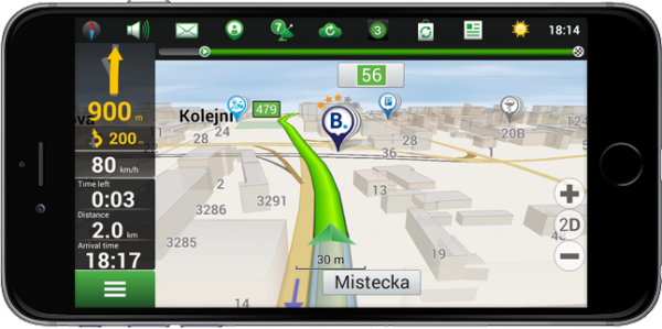
Navitel Navigator 9.5.30 Update for iPhone, iPad, Windows, Blackberry
Navitel Navigator 9.5.30 now allows users to reserve a hotel room with Booking.com within the app. Navitel also has added a sign for the second maneuver that appears when following a route, notifying the upcoming and next maneuver.
Annual revenues from connected healthcare and fitness services will approach $2 billion by 2019, nearly six times the $320 million value estimated for this year, according to a report from Juniper Research.
The report, “Smart Wireless Devices: CE, Enterprise, Fitness, Healthcare, Payments 2015-2019,” says that connected healthcare devices and the data they generate will offer substantial benefits to both stakeholders and consumers, potentially improving preventative healthcare. However, deployments will initially be constrained by inconsistent regulation, alongside continued privacy concerns surrounding the sharing and security of personal data.
‘Quantified Others’ are Key
The research highlights the “quantified others” trend: the use of someone’s data by a professional or concerned party — such as a parent — to provide meaning and/or advice. Companies like GOQii and Filip Technologies are using this to provide services beyond mere data provision.
Although, this has the potential to be undermined by unreliable data. While medical devices have validation standards, fitness devices have no such benchmark. The development of standards would alleviate consumer and medical professionals’ concerns, driving up adoption.
Software to Drive Connected Devices Forward
“Connected fitness and health devices provide a way to collect biometric data, not interaction platforms,” said author James Moar. “People want to interact with the devices at the app level – the draw is the information. Because of this, and the omnipresence of sensors, the importance of the hardware will diminish at a much faster rate than other CE market segments.”
Other Findings from the Report
Other findings were mentioned in a news release from Juniper Research, and are listed below:
“Smart Wireless Devices will permeate the enterprise, with smart glasses in particular having a large impact.”
“Mobile point-of-sale devices are poised to take off in developing markets, with several key players looking to move into Latin America and Asia Pacific in the coming years.”
“Smartwatches will be the most popular consumer electronics connected devices, overtaking more established wearable cameras.”
The white paper, Smart Wireless Devices & the Internet of Me, is available to download from the Juniper website together with details of the full research and the Interactive Forecast Excel (IFxl).
GIS software company Caliper is offering 114th Congressional Districts data for the United States for its Mapitude software. The data package is aimed at corporate legislative affairs departments, lobbyists, political consultants, political parties, and anyone else involved in political affairs.
The 114th Congressional Districts data contains a nationwide area database with boundaries of the 114th (January 2015-January 2017) Congressional Districts. It also includes demographic data from the 2010 Census and from the 2013 American Community Survey (ACS) five-year estimates.
Country Packages
Also available are eight new 2015 Country Packages for Maptitude. The 2015 Country Packages include fourth-quarter 2014 map content. Updated map layers, such as refreshed streets and landmarks are provided for each country. In addition, postal boundaries, postcode points, and demographics are included where available. For detailed information on each Package, including those for countries not mentioned here, visit the Maptitude Included Data page.
In the latest update of its Motion Tracker product portfolio, Xsens has added active heading stabilization (AHS) to its core sensor fusion algorithms on the MTi 10-series and MTi 100-series. Both series are MEMS-based inertial measurement units (IMU), attitude and heading reference systems (AHRS), and vertical reference units (VRUs).
The AHS algorithm delivers fundamentally improved heading tracking accuracy, Xsens said. The improved robustness in heading tracking is particularly evident in Xsens’ line of vertical reference units (MTi-20 and MTi-200). These products now provide actively stabilized heading tracking, delivering 20x less drift than pure gyroscope dead reckoning for most application scenarios. This means heading tracking drift as low as 1 degree after one hour for many applications, while remaining fully immune to magnetic distortions.
Xsens said this characteristic makes the MTi line of products a highly accurate, but cost-effective solution for robotic/indoor navigation, camera stabilization, satellite communication, directional drilling, borehole/pipeline inspection and pedestrian navigation applications, Xsens said.
“Customers are already choosing our MTis because of their accurate heading tracking capabilities, but this algorithm will bring the accuracy to a whole new level, enabling more applications and creating new markets. The 12 cm2 MTi comes with an easy-to-use library, so that integrating the solution is straight-forward,” said Marcel van Hak, Product Manager of Industrial Applications for Xsens.
AHS is available immediately as a free firmware upgrade to all MTi customers as part of the just-released MT Software Suite 4.3.
The following video shows a demonstration of the Active Heading Stabilization, with the Xsens MTi is mounted on a robotic vacuum cleaner.
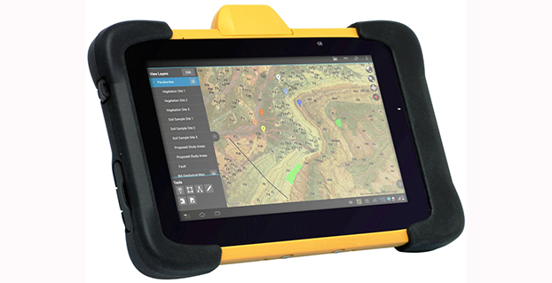
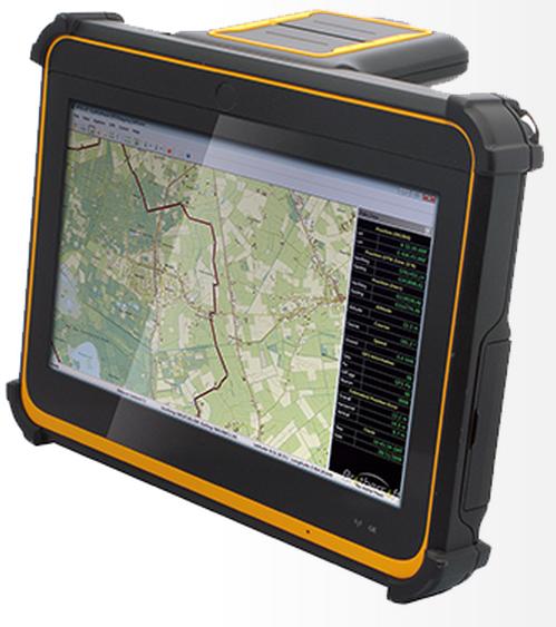
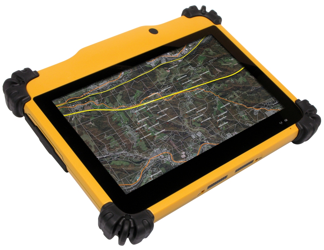
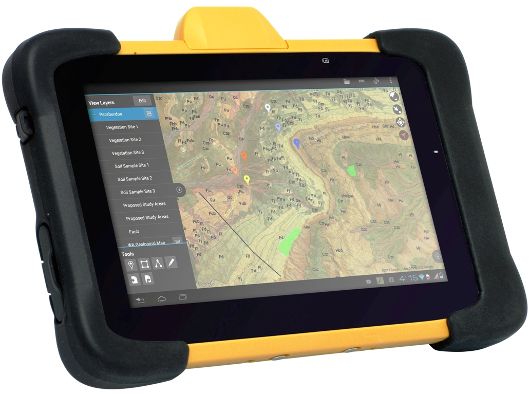
DT Research Inc. has launched a new line of rugged tablets with the GNSS modules for surveying and mapping applications. The DT391GS, DT395GS and DT307GS rugged tablets feature integrated high-accuracy GNSS receiver modules with built-in antenna for seamless data capture, the company said.
Built to travel and provide reliable operations in the real world, the tablets are designed for field work in mapping, geographic information systems (GIS), and accurate synchronization, tracking and networking.
The DT391GS combines a 9-inch sunlight-readable, capacitive touch display with an energy-efficient Intel dual-core processor in a compact, durable package. With the high-accuracy GNSS module options (Hemisphere or Trimble), the foldable antenna, and Windows or Android operating system. The DT391GS also offers protection in demanding environments with IP65 and MIL-STD-810G ratings for dust and water, and shock and vibration resistance.
The DT395GS tablet.
The DT395GS offers a 9-inch sunlight-readable capacitive touch screen, an energy efficient Intel dual-core processor, and a choice of Windows or Android operating systems. The GNSS positioning module has u-blox GNSS module. The IP65 rating, and military-standard MILSTD-810G and MIL-STD-461F ratings, as well as wide temperature range, make the DT395GS reliable even in harsh, mission-critical environments.
The DT307GS GNSS tablet features a brilliant 7-inch capacitive touch screen and a quad-core, energy efficient processor with a built-in, high-accuracy u-blox GNSS module. The size and weight of the DT307GS make this tablet portable for long-term handling in the field, DT Research said.
The DT307GS tablet
All of the DT Research Rugged GS Tablets offer hot-swappable batteries for continuous operation, enabling real-time project efficiency between staff in the field and in the office. With wireless support for Bluetooth, 802.11, WCDMA and HSPA+ connectivity and optional GSM networking, the tablets keep staff connected from any location.
The DT391GS and DT395GS have Trusted Processing Module (TPM) encryption for security support, and a choice of Microsoft Windows Embedded Standard 7 or 7 Professional, or Android operating system making these tablets flexible to integrate with existing applications.
An optional 5-megapixel camera offers another data capture tool to record visual information, and an optional 3G cellular data module provides data connectivity for navigation and real-time data transfer, DT Research said.
The DT391GS, DT395GS, and DT307GS are available now, form more information, contact DT Research at [email protected].
GPSTrackIt.com has added the ability to allow vehicles in Fleet Manager, its fleet and mobile workforce management system, to simultaneously belong to multiple groups. The feature enables groups to be “nested,” expanding the reporting and alerting capabilities of Fleet Manager.
“A vehicle belonging to more than a single group now appears in the list for each group selected,” said Eddie Bermudez, GPSTrackIt.com’s product development manager. “Units in two groups will appear twice, once in each group.”
Vehicle membership in multiple groups can be seen in the following changes to Fleet Manager:
The Vehicle Status page has been augmented with a selection/filter list for groups.
On the Map page, the information bubble for the unit displays all group tags.
The Analytics Dashboard can now compare two groups containing the same unit.
Scheduled Reports can be run using multiple groups.
“This enables the creation of ‘nested’ or vehicle sub-groups,” Bermudez said. “Say there are sales teams at local offices. Each office has a ‘sales team’ vehicle group. But the regional sales manager is responsible for five locations, so the vehicles are also in the ‘regional sales team’ group.”