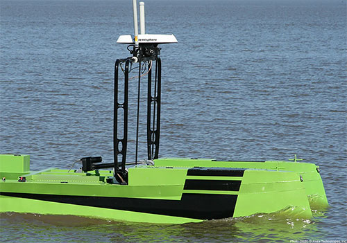
Hemisphere GNSS is offering a new RTK-enabled Vector V320 GNSS compass. The Vector V320 smart antenna supports multi-frequency GPS, GLONASS, Galileo (future firmware upgrade required) and BeiDou, and Hemisphere GNSS says it’s “the first of its kind.”
Designed for the professional marine and marine survey markets, the Vector V320 is the a multi-frequency, multi-GNSS, all-in-one smart antenna capable of both RTK-level positioning accuracy and better than 0.2-degree heading accuracy in a simple-to-install package.
“The Vector V320 combines our expertise in GNSS and smart antenna design,” said Lyle Geck, senior manager, Product Marketing, at Hemisphere GNSS. “With RTK performance that competes with current industry leaders, extremely accurate accelerometer-aided GNSS heading, and the simplicity of install offered by the smart antenna design, it is an incredible product.”
The Vector V320 is the latest in a line of GPS/GNSS compasses, including the multi-frequency, multi-GNSS Vector VS330 receiver as well as the Vector V102, Vector V103 and Vector V104 compass smart antennas.
“There has been a void in the market. Our customers have been looking for a product that provides RTK accuracy together with precision heading in an easy-to-install package,” said Andy Smith, managing director of Saderet Ltd. “The Vector V320 delivers.”
The Vector V320 GNSS compass is being featured by Hemisphere GNSS at Ocean Business in Southampton, UK, April 14-16, at stand K12.
SimActive Inc., a developer of photogrammetry software, has released Correlator3D version 6.1, now with point cloud generation.
The new feature builds on SimActive’s autocorrelation techniques using the GPU. Point clouds are generated in parallel with digital surface models (DSMs), with virtually no added processing time. As with previous versions, digital terrain models (DTMs) can also be automatically extracted in a matter of seconds.
“Although the DSM remains the de-facto deliverable for all mapping projects, an increase in interest from our UAV users led to the added functionality,” said Louis Simard, CTO of SimActive. “This further solidifies Correlator3D as a one-stop solution.”
One of the Honeywell Global Tracking ESA installations.
Honeywell’s Global Tracking solution has passed the final acceptance test for use on the European Space Agency’s (ESA) Galileo search and rescue program by demonstrating dramatically reduced emergency response times, Honeywell said.
Honeywell Global Tracking, part of Honeywell’s Scanning and Mobility business, is working in partnership with the Aerospace & Defense division of Capgemini, the prime contractor for the Galileo search and rescue program, to deliver a high-precision positioning system that is fully compatible with the international standard, which is known as the Cospas-Sarsat standard. Tests using the Honeywell system have proven that the time from beacon transmission to detection and processing has been reduced from several hours to a few minutes — often the difference between life and death in an emergency situation.
The international Cospas-Sarsat program is a satellite-based search and rescue distress alert detection and information distribution system, best known for detecting and locating emergency beacons activated by aircraft, ships and remotely located people in distress. Honeywell’s satellite tracking technology, which detects faint alerts sent by emergency beacons around the world using a combination of Doppler curves, noise reduction, and advanced signal processing, quickly calculates the exact location of the beacon and sends the results to the relevant Mission Control Centers in the region.
“Our Medium Earth Orbit-based search and rescue solution will lead to faster recovery missions and improved international search and rescue operations, and we’re pleased to partner with the European Space Agency to help execute on this important, life-saving system,” said David Sharratt, general manager, Honeywell Global Tracking. “With decades of experience developing this technology, Honeywell Global Tracking is the global leader of search and rescue solutions.”
“Up until now, Cospas-Sarsat has relied on satellites in low and high orbits, but medium orbits with satellites such as Galileo are better for search and rescue purposes; they combine a wide field of view with strong Doppler shift, making it more likely a distress signal is pinpointed promptly and accurately,” said Fermin Alvarez, ground station and fielding engineer with ESA. “Together with Honeywell, we are encouraged to see Galileo performing so strongly, thereby solidifying our ability to support precise and speedy search and rescue efforts.”
Cobham AvComm, formerly the Aeroflex AvComm business unit, has introduced the ATC-5000NG NextGen ATC/DME Test Set.
Designed for engineering development, design validation, manufacturing and return-to-service test applications, the ATC-5000NG is the replacement product for the legacy SDX-2000 and the ATC-1400A/S-1403DL. The software defined radio architecture supports more transponder RTCA DO-181E test capability than the legacy products did and has new capability needed to support the Federal Aviation Administration’s NextGen test requirements including ADS-B (RTCA DO-260B) and UAT (RTCA DO-282).
ADS-B is the Automatic Dependent Surveillance-Broadcast for next-generation (NextGen) aircraft navigation. The FAA has mandated that aircraft operating in airspace that now requires a Mode C transponder must be equipped with ADS-B Out by Jan. 1, 2020.
“We are excited to introduce the new ATC-5000NG which offers our customers the most comprehensive test set available in the market today. This will help our customers prepare for new requirements driven by the FAA’s NextGen and Europe’s SESAR projects,” said Ryan Panos, vice president and general manager of Cobham AvComm.
In September 2014, Cobham completed its acquisition of Aeroflex for $1.46 billion.
DARPA is looking for technology communities that can team to provide expertise and innovation for small sensors, expendable and small unmanned systems, and distributed communications and navigation technology.
The Defense Advanced Research Projects Agency (DARPA) is researching a drone that can hibernate on the ocean floor for years at a time before being launched to the surface and into the air.
The “Upward Falling Payload” (UFP) concept centers on developing deployable, unmanned, nonlethal distributed systems that lie on the deep-ocean floor in special containers for years at a time. These deep-sea nodes could be remotely activated when needed and recalled to the surface. As DARPA terms it, they “fall upward.”
The new drones are part of a new focus by the U.S. military to develop and improve technology for emerging threats. “Today, cost and complexity limit the Navy to fewer weapons systems and platforms, causing strain on resources that must operate over vast maritime areas. Unmanned systems and sensors are commonly envisioned to fill coverage gaps and take action at a distance. However, power and logistics to deliver these systems over vast ocean areas limit their utility. The Upward Falling Payload (UFP) program intends to overcome these barriers,” DARPA said on its website.
DARPA’s statement continues: “Nearly 50 percent of the world’s oceans are deeper than 4 km, which provides vast areas for concealment and storage. As a consequence, the cost to retrieve UFP nodes is asymmetric with the likely cost to produce and distribute them to the seafloor. Concealment provided by the sea also provides the opportunity to quickly engage remote assets that may have been dormant and undetected for long periods of time, while its vastness allows simultaneous operation across great distances. Getting close to objects without warning, and instantiating distributed systems without delay, are key attributes of UFP capability.”
The UFP system would have three key subsystems:
The payload, which executes waterborne or airborne applications after being deployed to the surface
The UFP riser, which provides pressure tolerant encapsulation and launch of the payload
The UFP communications, which trigger the UFP riser to launch.
The program would need to demonstrate a system that can:
survive for years under extreme pressure
be triggered reliably from standoff commands
rapidly rise through a water column and deploy its payload.
The drones wouldn’t require fuel, as they would be powered with energy generated by ocean currents. Ocean drones would be difficult to manufacture, however, because researchers would need to figure out how to activate the drone, how to help the drone breach the surface, and make sure the drone is protected in salt water for long periods.
This artist’s concept shows a potential communications application of an upward falling payload. (Credit: DARPA)
Phase 2. The program is completing its first phase and is about to enter its second. During Phase 1, DARPA supported more than 10 study and design efforts to figure out approaches for long-range communications, deep-ocean high-pressure containment, and payload launch. The study teams also addressed a variety of missions for the payloads.
“In this first phase, we really learned about how the pieces come together, and built a community of developers to think differently about unmanned distributed solutions for the maritime domain,” said Andy Coon, DARPA Program Manager for the effort. “The trick is to show how these systems offer lower-cost alternatives to traditional approaches, and that they scale well to large open-ocean areas.”
In the next Phase, DARPA intends to learn from the studies, and develop and demonstrate prototype systems. DARPA is seeking teams to develop UFP nodes that combine expertise in both deep-ocean engineering and advanced payload development.
“We’re also looking for the communications technologies for these nodes. As long as you can command the nodes remotely and quickly, and don’t have to send a ship out to launch it, you’re in good shape. Some Phase 1 approaches were more exotic than others, but we were pleased by the range of challenging options,” said Coon.
In today’s fiscally constrained environment, such a system of pre-positioned, deep-sea nodes could provide a full range of maritime mission sets that are more cost-effective than existing manned or long-range unmanned naval assets.
For Phase 2, DARPA is particularly looking for technology communities that can team to provide expertise and innovation for small sensors, expendable and small unmanned systems, distributed communications and navigation technology, novel long-range underwater communications, and long-endurance mechanical and electrical systems that can survive for years in dormant states.
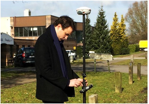
Experiencing the Qiao Station with ComNav T300 for surveying.
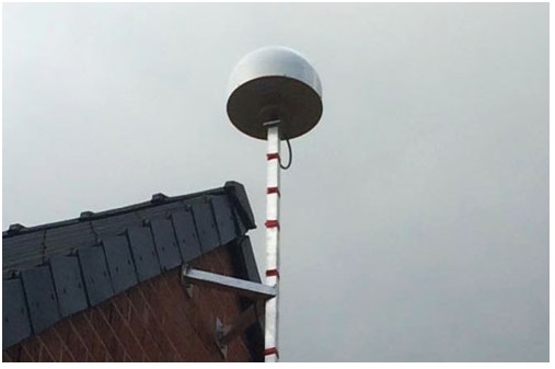
Europe’s first commercial BeiDou CORS station — Qiao CORS Station — has been built in Wallonia, Belgium. ComNav partnered with local company CGEOS – Creative Geosensing on the project. ComNav develops and manufactures GNSS OEM boards and receivers for demanding high-precision positioning applications.
Qiao means bridge in Chinese, and Joël van Cranenbroeck, managing director of CGEOS, is working to build the bridge between the Chinese and European GNSS industries by introducing the Chinese high-precision GNSS technologies of ComNav Technology to European users, ComNav said in a statement.
The Qiao Station can track BeiDou Navigation Satellite System on the three frequencies and transmit observation data in RTCM format in real time through NTRIP and observation data in RINEX format. It enhances the positioning performance and result by combining BeiDou with GPS and GLONASS.
Currently, the BeiDou Navigation Satellite System mainly covers the Asia Pacific region. Though China is still in the process of building it into a global network, up to six BeiDou satellites can now be tracked in Europe during certain periods of the day. With the new Qiao Station, European users can now try the BeiDou system.
Setting up Qiao Station.
European’s first BeiDou CORS station has been built in Belgium.
TU-Automotive has announced finalists in several categories for its 2015 awards. Finalists in the Best Connected Car System Integrator category include chipmakers Qualcomm and u-blox, among others. Nominees in other categories include TomTom, NXP Semiconductors, Telogis and Geotab.
The finalists represent excellence, innovation and leadership in the connected car industry, TU-Automotive said.
More than 400 entries were submitted. The winners will be revealed at the TU-Automotive Awards Ceremony on June 2 in Detroit. Here is the full list of finalists:
Car Maker of the Year 2015
Audi
BMW of North America, LLC
Ford Motor Company
Qoros auto
Toyota Motor Sales
Volvo Car Group
Commercial Vehicle Maker of the Year
Mack Trucks
Scania CV AB
Volvo AB
Telematics Service Provider of the Year
Airbiquity
Ericsson
General Motors
Jasper
Nuance Communications, Inc.
Total Traffic and Weather Network
Xtime
Commercial Telematics Service Provider of the Year
Inthinc Technology Solutions Inc.
Openmatics
Teletrac Inc
Telogis
Best Connected Car System Integrator
Atos
AutonomouStuff LLC
HERE, a Nokia company
Car Connectivity Consortium
Covisint
Dash Labs
Elektrobit (EB) Automotive
Luxoft
Movimento
Parkopedia
Qualcomm Technologies, Inc.
Symphony Teleca Corp.
u-blox AG
Uievolution, Inc.
Best Commercial Vehicle System Integrator
Eyeris
Geotab
KPIT Technologies Ltd.
Navistar
Spireon, Inc.
Symphony Teleca Corp.
TomTom Telematics
Best Insurance Telematics Product
Allstate Insurance Company
AXA & MyDrive Solution
Codan Insurance (RSA) & The Floow
Direct Auto Insurance & DriveFactor
Industrielle Alliance, Assurance auto et habitation inc. & Baseline Telematics
Progressive Insurance & zubie inc
RightTrack® by Liberty Mutual & Octo Telematics North America
Suncorp Group & Wunelli, a LexisNexis Company
Best Telematics Product or Launch in an Emerging Market
CarIQ Technologies Private Limited.
Discovery Insure
iTrans Technologies Pvt Ltd
Omnicomm
Qoros Auto
TATA Motors Ltd, India
TechMahindra
TOWER Insurance (in partnership w/ DriveFactor Inc.)
Best Safety or ADAS Solution
Argus Cyber Security
BrightWay Vision
Delphi Automotive PLC
Elektrobit (EB) Automotive
Eyeris
General Motors
NXP Semiconductors
TomTom
Valeo Wiper Systems
Best Mobility Solution Industry Newcomer
Carma
County of Santa Clara Roads & Airports Department
Dash Labs
Hyundai Blue Link Smartwatch app
Local Motion
moovel GmbH
parku – The Parking App
QNX Software Systems
Industry Newcomer
ATG Risk Solutions
CarKnow LLC
CloudCar
Dealer-FX
Eyeris
gestigon
MobiWize
Nebula Systems Ltd
Rivet Radio, Inc.
TowerSec
TU-Automotive Influencer of the Year
Andrew Poliak, Global Director Business Development – Automotive, QNX Software Systems
The TeeJet Matrix 430 is a low-cost GNSS guidance system featuring a graphical, touchscreen user interface that allows for fast setup and intuitive operation. The system is designed for a wide range of field applications including spraying, spreading, tillage and solid seeding.
The Matrix 430 features a 4.3-inch/110-mm high-contrast, full-color display for excellent visibility, even in bright light conditions, TeeJet said. It contains an integral GNSS receiver that supports both GPS and GLONASS signals with a choice of two available antennas for enhanced performance in a wide range of geographies.
Other features include: return-to-point, coverage mapping, field area measurement, applied area alert, elapsed time counter, simple job reporting, and a choice of four guidance modes: Straight AB, Curved AB, Center Pivot, and Last Pass.
“The Matrix 430 builds upon our highly successful and proven CenterLine 220 guidance product while providing an enhanced user interface and expanded capabilities,” said Tim Stuenkel, global marketing manager with TeeJet Technologies. “This product is designed for the grower who wants a simple, affordable guidance system — whether they are a first time buyer or experienced user of GNSS guidance products.”
TeeJet Technologies manufactures a comprehensive line of products including agricultural spray nozzles for various pesticide/fertilizer applications, boom components, valves/manifolds, strainers, and spray guns, as well as GPS guidance systems, sprayer control systems, ISOBUS job computers, assisted steering systems and other precision farming products. In addition, TeeJet Technologies continues to invest in research and development to advance precision application and control technology.
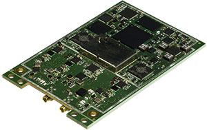
Septentrio has launched its next-generation dual-antenna GNSS receiver, the AsteRx 4 OEM. The AsteRx 4 OEM is a multi-frequency, dual antenna receiver that incorporates the latest innovative GNSS tracking and positioning algorithms from Septentrio. It offers users in the marine, machine control and agricultural industries precision, accuracy, reliability and ease of use, the company said.
Thanks to Septentrio’s positioning engine, which uses advanced multipath and ionosphere modeling algorithms, the AsteRx4 offers robust positioning scalable from meter to centimeter accuracy. Together with precise heading and reliable error estimates, the AsteRx 4 OEM functions in tough conditions on land, at sea or in the air.
Use of all available constellations (GPS, GLONASS, BeiDou, Galileo) provide the operator with a reliable solution even in obstructed areas such as in narrow city streets or at the corners of large structures, Septentrio said. The AsteRx4 OEM features the full range of positioning techniques from stand-alone to real-time kinematic (RTK).
For users who operate in more remote regions of the globe, the AsteRx4 OEM supports Veripos and Terrastar correction PPP services. Furthermore, the receiver features special interference mitigation technology which filters out ambient intentional and unintentional RF interference.
The AsteRx4 OEM is straightforward to set up and integrate with existing systems, Septentrio said. It has the similar hardware interface as earlier AsteRx receivers, and supports the same open and well documented command and binary output format. Users will be able to operate their receiver without special configuration software by using the very accessible web interface, which is available via network and USB connections.
“AsteRx4 incorporates many powerful improvements based on practical difficulties our customers face in the field every day,” said Jan Van Hees, vice president of Business Development, Septentrio. “We are particularly proud of the solutions for interference robustness that we have incorporated into our new ASIC, the GReCo4; the solid and reliable positioning algorithms that result from taking the receivers into the most extreme environments and from focusing not only on accuracy, but on reliability of the position solution.”
The AsteRx4, along with all the AsteRx family of receivers, will be on display at booth W40 for the duration of Ocean Business 2015 starting April 14 at the National Oceanography Centre, Southampton, UK.
The Federal Aviation Administration has approved 30 more commercial unmanned aircraft systems exemptions, bringing the total number of approved operations to 99, reports AUVSI News. AUVSI is the Association for Unmanned Vehicle Systems International.
Among those receiving exemptions are the insurance companies USAA and AIG. USAA said in a press release that the exemption “could help speed review of insurance claims from its members following natural disasters.” USAA plans to fly the PrecisionHawk drone.
USAA also filed for an additional FAA exemption in November that will enhance USAA’s ability to use drones in catastrophes. That exemption petition is pending approval, and a decision is expected soon.
Other companies receiving exemptions include senseFly for precision agriculture, and AeroVironment for agriculture, aerial survey and patrol applications.
As I write this, the 31st Space Symposium (SS) will kickoff in just 5 days, on April 13 at the incomparable Broadmoor Resort in Colorado Springs, Colo., at the foothills of the beautiful Rocky Mountains.
Neil deGrasse Tyson (courtesy of PBS)
If you haven’t figured it out already, the 31st SS is not a WWII German unit designation, but the 31st Space Symposium, which Dr. Neil deGrasse Tyson, famed astrophysicist, bestselling author, director of the Hayden Planetarium and host of the hugely successful television series Cosmos: A Spacetime Odyssey, simply calls “the most awesome symposium in the world.” Very high praise indeed, and a sentiment with which I totally agree.
Breaking Records
This year’s Space Symposium, which is sponsored by the Space Foundation, will be the largest ever held in terms of venue, size (number of exhibitors and speakers) and attendance. Approximately 10,000 space enthusiasts are expected to attend, and I hope you are one of them. My sources tell me the classified sessions (Cyber 1.5 and classified space sessions) are filled to overflowing — no new registrations allowed there. The exhibitor space at the Ball Aerospace Exhibit Center and Pavilion is bursting at the seams. The organizers are turning exhibitors away, so better luck next year. But if you just want to attend the greatest space symposium in the world, bar none, there is still time to register.
By the way, if you haven’t figured it out already, this is a truly international event. My sources at the Space Foundation stated that the 31st Space Symposium will have more international participation than ever, including more than 150 exhibits of the world’s latest space technology, products and services. The Ball Aerospace Exhibit Center will host more than 30 first-time exhibitors with more than a dozen countries represented, including: Austria, Canada, Denmark, France, Germany, Japan, New Zealand, Norway, Scotland, Sweden, Turkey, the UK and the U.S. The symposium is expected to attract space leaders from more than 25 countries, representing all sectors of the global space community.
Everyone who is anyone in the space world will probably be there or be represented. Consequently, the networking capabilities are unparalleled. Not to mention just being able to avail yourself of the world-famous Broadmoor Resort hospitality, plus the crisp, clean and cool mountain air at 6,000 feet.
Event Preparation
For many years, the event was known as the National Space Symposium. It outgrew that moniker many years ago, and is now simply known as the Space Symposium.
Every year before I attend the Space Symposium, I make a “ToDoToDay” list of topics I want to explore, both as a journalist and in my senior space analyst profession. Plus, of course, I make a list of people I definitely want to talk with or interview. This year, I thought I would share some of those to-dos with you, because you may indeed have some of the same interests.
GPS III
Mark Stewart, Lockheed Martin GPS III program manager (courtesy of Lockheed Martin)
Wearing my subject matter expert (SME) hat, so to speak, I recently had the honor of touring the Lockheed Martin (LMCO) Space Systems facility in Waterton Canyon (far West Denver), Colorado, where the GPS III satellites are built, integrated and otherwise readied for launch. I took the opportunity to chat with Mark Stewart and his crew. Mark is vice president for manufacturing and space systems and program manager for GPS III.
I learned that the first GPS III space vehicles (SVs) is much farther along than most everyone thinks. The problematic MDU (Mission Data Unit — the heart of the system) from Exelis has been fully tested and integrated into the payload. GPS III SV1 was only three days from being totally integrated or mated, as they say, with the on-orbit propulsion portion of the payload (the remainder of the LMCO A2100 bus) and beginning its months-long testing, certification and verification process. According to Mark, GPS III SV-01 — which powered on initially in February 2013 — now is in integration and test flow leading up to final delivery to the Air Force.
While it was thrilling to see everything finally coming together, I will also tell you candidly that the next milestone everyone is asking about, the first GPS III launch date, is probably as fluid as the Snake River in Spring. So, while I do not feel comfortable quoting a first launch date, and LMCO would not give me a firm date for delivery of the first GPS III SV, I do feel comfortable making this prediction: Barring any unforeseen major issues during testing, LMCO will be ready to deliver to the U.S. government the first ready-to-launch GPS III satellite by the end of this calendar year. That’s right, in my humble opinion the first GPS III SV will be ready to deliver to the Air Force by December 2015. When it will actually be launched is anybody’s guess; obviously, the sooner the better. Apropos of the Boeing IIF initial launches and critical on-orbit anomalies, the sooner the LMCO GPS III is put into orbit for full-scale operational and mission analysis tests the better.
LADO and OCX
The critical question of course is: Will the U.S. Air Force (USAF) have a ground control system that can successfully and reliably launch and support a full-up GPS III SV by the end of 2015? Certainly not if they stay the course with OCX, but there are alternatives, and you know who you are! Can you say LADO, Launch/Early Orbit, Anomaly Resolution, Disposal and Operations System?
Consider that LADO has been utilized to launch GPS satellites as far back as the GPS IIR-M family of satellites, also produced by LMCO, one of which was successfully launched on October 17, 2007, using the then-new LADO system. That milestone ensured the GPS program continued to provide superior space-based navigation for billions of users, military, civilian and commercial, around the globe using industry-leading highly modified (Aces Premier) commercial launch technology. This significant achievement was the culmination of outstanding teamwork between the USAF, Braxton Technologies, the engineering firm and the prime contractor.
The LADO system formed and is still the backbone of the new GPS Command and Control (C2) functionality implemented by the prime contractor. It known today as the Advanced Architecture Evolution Plan (AEP). Subsequently, LADO is now the primary launch system for all current and future (IIR-M, IIF and possibly GPS III) satellites, which should allow the U.S. Air Force to retire some outdated legacy GPS ground support and command and control systems.
The first successful 2007 LADO launch and control of an operational GPS IIR-M satellite, and the 1SOPS and 2SOPS operators’ acceptance of the GPS LADO system, was proof that commercial software can be deployed effectively even in a militarily critical mission system, saving the government both cost and schedule without sacrificing mission-unique capabilities.
In my humble opinion, that is where we need to go today. Let’s return to the tried-and-true LADO and prime contractor partnership and launch the first GPS III SV by the end of this year, or certainly by early 2016. Please notice I have not made any statements concerning scrapping the hugely expensive, 100-percent-over-budget-and-schedule (years behind) OCX program of record. Under Secretary of Defense for Acquisition, Technology and Logistics (USDATL) Frank Kendall recently announced the controversial decision that OCX as the program of record would go forward under strict scrutiny with definite milestones that must be met. Scrutiny is a fickle mistress, and historically on the OCX program, milestones are there to be missed. Meanwhile, the USAF requires a tried, proven and utterly reliable capability to launch GPS III SVs as soon as the first few become available. The USAF must place several GPS IIIs on orbit for a full checkout to ensure there are no major anomalies. Currently, LADO had an eight-year proven track record with no failures, and it remains the only program that can initiate, control and dispose of residual GPS satellites — including the IIAs, which are the longest lived GPS satellites on orbit today.
Beware, there will be many naysayers in government circles, and you may meet some of them at the symposium, that will tell you it is just not possible. But just stop by and talk candidly with LMCO Space Systems and Braxton Technologies personnel, and see what they have to say. You may be surprised by what you hear.
Then stop by the Raytheon booth and check on the status of OCX.
Lynn Dugle (courtesy of Raytheon)
Female Executives in the News
Speaking of OCX and Raytheon, Lynn Dugle retired from Raytheon on March 2, 2015. Historically, Lynn has been a very capable executive. She is the former president of Raytheon’s Intelligence, Information and Services (IIS) business, which handles several key U.S. Air Force space contracts, including OCX, the current program of record for the next-generation ground system for GPS III. Dugle served as president of the division beginning in 2009.
David Wajsgras (your guess is as good as mine), Raytheon’s former senior vice president (SVP) and chief financial officer (CFO), has replaced Dugle. Wajsgras served as SVP and CFO of Raytheon Company from March 2006 to March 2015.
David Wajsgras (courtesy of Raytheon)
As a member of Raytheon’s senior leadership team, he directed Raytheon’s overall financial strategy. In my humble opinion, he has his work cut out for him. He will need all of his financial expertise and acumen to make OCX a success — financially and, hopefully, operationally. The program is grossly over budget, several years behind schedule, and reportedly, my sources tell me, far less capable than originally planned. Good luck, David.
As long as we are still speaking primarily of female executives with great track records, USAF Lieutenant General Ellen Pawlikowski, who I have had the honor of knowing and working with for the past 25 years, was recently nominated for her fourth star. General Pawlikowski successfully commanded the SMC (Space and Missile Systems Center) and served as Program Executive Officer (PEO) for Space for three years at Los Angeles Air Force Base in California. Among her many successful space acquisition programs, she was responsible for GPS procurement during her tenure.
Lt. Gen. Ellen Pawlikowski, USAF (courtesy of the USAF)
Currently, General Pawlikowski serves on the East Coast in the Pentagon as the military deputy to William LaPlante, Ph.D., the assistant secretary of the Air Force for acquisition. In other words, LaPlante is the Air Force’s Service Acquisition Executive, responsible for all Air Force research, development and acquisition activities. Previously, just to add to her mystique, General Pawlikowski spent more than one tour at the super secret National Reconnaissance Office.
When confirmed, General Pawlikowski will be only the third female four-star general in U.S. Air Force history. A well-deserved honor and one that certainly merits acknowledgement. General Pawlikowski is scheduled to speak several times at the Space Symposium, so when you see her, congratulate her on a job well done and on being nominated for her fourth star, and wish her luck in her new assignment as the head (four-star commander) of Air Force Materiel Command.
Before we leave the female leader category, my sources tell me that USAF Colonel DeAnna Burt, commander of the 2nd Space Operations Squadron (2 SOPS, the GPS squadron) from 2008 to 2010, will in June 2015 become only the third female commander of the 50th Space Wing at Schriever AFB, Colorado — home to 2 SOPS. She follows in the very capable footsteps of then-Colonel Suzanne (Zan) Vautrinot, who was the first female wing commander at the50th Space Wing followed by then-Colonel Teresa (Terry) Djuric. Note that both Suzanne and Terry, who are now retired from active duty, went on to become general officers in the USAF.
Commander AFSPC – Gen. John Hyten (courtesy of the USAF)
Currently, Colonel Burt serves as director of the Air Force Space Command (AFSPC) Commander’s Action Group for General John Hyten. General Hyten, the current commander of AFSPC, is himself a former 50th Space Wing commander, and he will also be speaking several times at the space symposium. Here’s a big hint: As a four-star general, General Hyten has morphed into quite a forceful, informative, entertaining and engaging speaker. You won’t want to miss any of his presentations.
If you see Colonel Burt at the Space Symposium, please congratulate her on her new assignment, and you might offer her your prayers for the incredible amount of responsibility she is about to assume. I’m betting she can handle it.
GPS Directorate
Another USAF general officer you are sure to run into at the Space Symposium is a newly minted brigadier general known by some as Wild Bill Cooley. General Cooley, who is currently the director of the GPS Directorate at SMC, was pinned on just a few weeks ago and will be speaking several times at the symposium. Wild Bill also deserves your congratulations. By all accounts, he is doing a great job and has more stars in his future.
The Place to Be
So, while there are several points to be made, a key one appears to be that if you are heavily involved with the GPS program inside and outside the USAF and you do a good job, it can work wonders for your career. If you want to hear from those who have been successful, the 31st Space Symposium is the place to be.
I hope to see you at the Broadmoor April 13-16. Come early and wear your walking shoes. Please stop by the GPS World booth and say hello to everyone. I will be there for sure.
As I wind up this to-do list, I will tell you about another Space Symposium event where it is important, even critical, to be seen. Everyone who is anyone will be attending the Connecting Colorado private function on Wednesday evening, April 15. The event is hosted by the Braxton Science and Technology Group; this is the third year for the coveted event. As I have stated before, I have attended 26 of the 31 Space Symposiums, and I have never been to an after-hours function during that time that even approaches the quality and class that Connecting Colorado exudes. It is a first-class event in a visually stunning venue, where private access passes are required to enter and guards are serious about keeping out gatecrashers. If history is any guide, it promises to be an amazing evening of fine wines, sumptuous food, quality cigars, roaring fireplaces and professional camaraderie that can’t be beat. Plus, the networking opportunities are endless. In other words, the Connecting Colorado event is what all the other after-hours Space Symposium events long to be or wish they could emulate. I can’t wait. I hope to see you there, and at the 31st Space Symposium. By the way, April in the Rocky Mountains means dress appropriately — warmly works for me.
Until next time, Happy Navigating, and remember: GPS is brought to you courtesy of the United States Air Force.
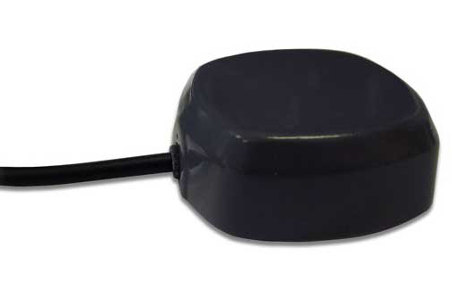
Two dual-feed GPS/GLONASS antennas from Tallysman’s GNSS antenna range are now available in Australia and New Zealand through M2M Connectivity. Tallysman is a Canada-based developer of high-performance GNSS antennas focused on the requirements for precision and multi-constellation GNSS receivers.
Featuring a dual-feed wide-band patch element, Tallysman’s TW2410 and TW4421 antennas cover the GPS L1, GLONASS G1 and SBAS (WAAS, EGNOS and MSAS) frequency band (1574 to 1606 MHz). The dual-feed patch provides excellent circular polarized signal reception, multipath rejection and out-of-band signal rejection, according to Tallysman.
Offering tight phase center variation (PCV), the antennas are suitable for high-accuracy applications and for use in precise point positioning (PPP) systems that require only a single frequency such as single-frequency RTK solutions, GNSS compasses and machine control.
Suitable for precision industrial, agricultural and military applications, the dual-feed GPS/GLONASS antennas feature Tallysman’s Accutenna technology that provides superior or multipath signal rejection and precision. The TW2410 and TW4421 antennas are housed in IP67 industrial-grade weather-proof, magnet mount enclosures and come with a wide range of connector options and cable lengths.
Tallysman is a manufacturer of high-performance, high-quality products for a wide range of GNSS applications.