Category: Applications

  • Self-Driving Cars Find Their Way at CES

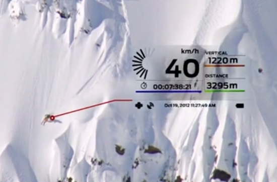
    This year’s CES featured the usual big TV screens, loudspeakers, wearables, 3D printers, drones and connected vehicles surrounded by 150,000 attendees over several Las Vegas meeting venues. What was interesting was the continued rise of autonomous, or self-driving, vehicles and platforms. Lost in all of the noise was a small, but important, location-based services enclave that consisted of GPS-enabled wearables and indoor positioning.

    LAS VEGAS—A big chunk of the estimated 30 billion worldwide connected devices will be those linked to vehicles, say industry experts at the International Consumer Electronics Show here. Nearly all automakers had a presence at CES — all with a long-term connected vehicle strategy.

    No matter how big and exhausting CES is, with long taxi lines and 150,000 attendees, there is good reason to come a day before the giant conference, as the Consumer Telematics Show and AT&T Developer’s Conference feature many industry executives and new developments. At the Consumer Telematics Show, speakers explained how and why connected vehicles are transitioning to autonomous capability.

    The connected car industry has matured to the point where technology and market points are coming together, said Thilo Koslowski, Gartner vice president and practice leader, automotive vehicle ICT mobility, at CTS. “The opportunity of connected vehicles are becoming the center of mobile and [Internet of Things] innovations. It has come from, in 1997, a pure telematics safety and security device to vehicle integration, digital lifestyle convergence and Internet of cars,” he said. “At the end of the year, there will be 25 million connected vehicles in the world, but most in mature markets. That might not look like a lot, but only in five more years, I think that number is going to 150 million vehicles.”

    In some cases, the newer outfitted vehicles will have only safety and security features, Koslowski said, but most will have two-way data communication, part of the 30 billion devices connected by 2020. He predicted last year that most automakers would have shifted general mobile applications to vehicle and customer-specific services.

    Koslowski says the top connected car features that consumers have asked for include automated map updates, real-time weather and news, parking spot finder and driving assessment and coaching. “Consumers don’t want application downloads directly into the car. In addition, in-vehicle media purchases are not there yet, as are in-vehicle social networking updates,” he said. “I predicted in 2013 that 25 percent of the automakers would monetize mobile commerce transactions in their connected vehicle offerings such as parking, buying gas, etc.,” he said.

    Self-Aware Vehicle Emergence

    Imagine sleeping, or reading, in your car during the morning commute. It may be a reality, but major technical, cultural and legal issues need to be resolved before fully autonomous vehicles hit the road. “There is going to be trouble if [automakers] don’t get consumers involved early on. Or allow governments and insurance companies telling people when to hit the button (to drive),” Koslowski said. “You press the [drive yourself] button and you pay 30 percent more in insurance. About 39 percent of those we surveyed are interested in some sort of self-driving car — that doesn’t mean fully autonomous vehicles. But 61 percent say they are not ready.”

    Koslowski says there is a lot of education that includes basic acceptance of the technology and trust that it really works. “There usually is a 30-second rule. The first 30 seconds is ‘holy moly, this thing drives itself’,” he said. “The second 30 seconds is ‘is this beneficial?’ There are real benefits such as reducing the cost of accidents, which amount to $900 per U.S. citizen.”

    In terms of cyber security and privacy, Koslowski said it’s a big deal for autonomous vehicles. “A couple of breaches will be a big deal. Still, consumers are not that paranoid. They are willing to share information, especially if there is a monetary or societal function,” he said.

    Cost is still big factor that will drive the adoption of autonomous vehicles. Koslowski says that consumers polled will only pay an additional $1,404 for autonomous capability. The cost of a test vehicle, right now, is about $85,000. “The good news is that number is coming down. It is shrinking to less than $6,595,” he said.

    At the Transportation Research Board meeting a week after CES in Washington, Chris Urmson, who heads Google’s self-driving vehicle program, said the Kentucky Fried Chicken bucket-looking gizmo on top of their car cost $70,000 alone.

    Cost aside, by 2016, three automakers will have concrete plans for upcoming autonomous vehicle launches, Koslowski said. “This is happening a lot faster from a technology standpoint than experts thought it would,” he said.

    Overall, Koslowski said that big IT companies need to step up to make autonomous vehicles work. “Governments are a little behind. The slowness of automotive companies also make them vulnerable to technology companies to step in and take over the industry,” he said.

    Indoor Positioning and Other Location Markets at CES

    Such companies as CSR were at CES and said the show was good for indoor location providers. “CES was good for us. We had good interest in our live demo of indoor location where customers were free to walk around testing the performance of our (solution). We also saw a lot of interest from the automotive market for an indoor/outdoor navigation (product), such as being able to find your way back to the car in a complex shopping mall and the best place to park for access to your indoor destination,” said Dave Huntingford, CSR’s director of product line for location.

    In 2015, the company believes that one of the key drivers for indoor location will be the ubiquity of maps for public locations, Huntingford said. “The availability of indoor maps for malls, airports and retail chains will help drive indoor location awareness with consumers for both utility value (not getting lost) and retail marketing applications,” he said. “We also expect to see a variety of social networking applications supporting indoor location, reflecting the fact that we spend the vast majority of time indoors.”

    Huntingford believes a key limitation of many indoor technologies is the requirement to have dedicated, or upgraded, infrastructure such as BT Smart beacons or updated Wi-Fi access points with new location capabilities, and a dedicated manual survey of the building to measure indoor Wi-Fi signatures.

    At CES, Magellan rolled out its line of 5-inch RoadMate Auto GPS Devices with 3D buildings and landmarks. “The units retail from $169 to $229. “We are surprised at the interest our PNDs are having in the market, particularly with back-up video,” said William Strand, Magellan associate director, product marketing. “The dash camera is a small market, but catching on to block insurance fraud.”

    In other CES news:

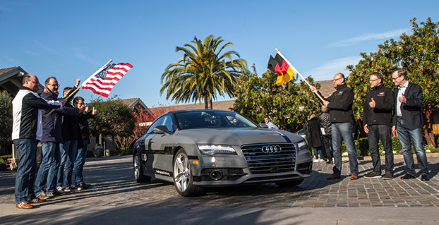
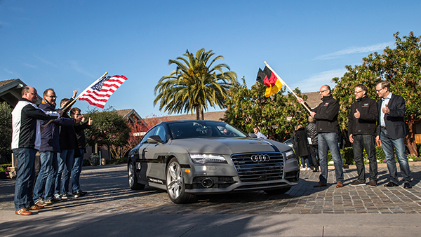
    • Audi pulled off a coup when it invited journalists to drive with its autonomous vehicle from San Francisco to Las Vegas.
    • Most location companies have wearables product lines that are making retail chains take notice.

    Transportation Research Board Meeting Becoming Big Autonomous Show

    WASHINGTON—The Transportation Research Board Annual Meeting here has grown to be one of the bigger autonomous vehicle meetings, with 12,000 mainly government execs and academics meeting.

    About 300 people showed up for a panel headlined by Chris Urmson, who heads up Google’s autonomous vehicle program. All was well and good hearing about Google’s self-driving vehicle technology except TRB had 100 chairs for 300 attendees…a lot of people left. But that is the level of interest autonomous vehicle is having in the government and academic community.

    “We are planning to find out how our car does with red lights flashing in front of it. The software will figure out, along with GPS and insertional and high-resolution maps,” Urmson said. “The world isn’t empty. Our vehicle has to know about the pick-up making a lane change, the bicyclist pedaling next to it.”

    Urmson said there are no sensors on the market that power the car — Google makes them in-house.

    In other TRB news, TomTom announced it is partnering with the I-95 Corridor Coalition. The company is using one of three main real-time traffic products in its portfolio, said Nick Cohn, TomTom senior business developer. “It is all about our TomTom Traffic Flow product, which provides speed information for individual road segments every minute, based on our mix of probe data sources,” he said. “This is one of three main real-time traffic products we have. TomTom Traffic provides one-minute updates of locations and delays of traffic jams and other traffic incidents. The third product is a set of APIs for providing, for example, travel times that can be displayed on variable message signs along roadways to inform drivers about delays.”

    The government market is a steady business for TomTom, which has seen traffic management success mainly in European cities such as Berlin, Rome and London, Cohn said.


  • Automakers No Longer the Neanderthals of Tech

    Automakers No Longer the Neanderthals of Tech

    Start of the 550 mile piloted drive from Silicon Valley to Las Vegas: Ricky Hudi, Executive Vice President Electric/Electronic Development, (left) and Ewald Gössmann, Excecutive Director Electronic Research Lab California (ERL), (third from right) drop the flag for the Audi A7 piloted driving concept car.  Photo: Audi
    Start of the 550 mile piloted drive from Silicon Valley to Las Vegas: Ricky Hudi, Executive Vice President Electric/Electronic Development, (left) and Ewald Gössmann, Excecutive Director Electronic Research Lab California (ERL), (third from right) drop the flag for the Audi A7 piloted driving concept car. Photo: Audi

    In the wake of CES and the North American International Auto Show in Detroit, it’s clear that times are a-changing. Self-driving concept cars filled three football-field-sized areas to show off what lies ahead. Verizon and Ford did a cosmic switcheroo, with Verizon morphing into the auto space and Ford starting a transformation into a mobility company. Automated reality/augmented reality isn’t as big as would be expected, and is suffering from a lack of content. Wearables continue to do remarkable things, notably in the health and fitness sector, and smart watches will become more exciting with interaction to vehicles and home.

    Janice Partyka
    Janice Partyka

    When Mark Field, current CEO of Ford, announced the Ford Sync from the CES stage in 2007, attendees found the presence of an auto company at CES to be out of place. The auto industry was considered Neanderthals of tech. Today, the most exciting mobile technology is vehicle related, and more exciting developments from the auto industry were seen in Las Vegas, rather than Detroit.

    Field was back at CES with a visionary perspective that Ford isn’t going to be just about cars and trucks. He is broadening Ford’s focus to mobility in preparation of the changes in transportation that will occur in response to global megatrends of urbanization, growth of the middle class, air-quality issues and evolving consumer attitudes. To test out new ideas of flexible user-ship and collaborative transportation, Ford is operating 25 experiments around the world to test out solutions for specific mobility challenges. Ford is looking to be a leader and enabler of a market where people may be sharing or swapping vehicles or relying on crowd-based transportation. It is refreshing to see out-of-the-box thinking from Detroit.

    Ford Mobility Experiment in London — driving-on-demand with Ford fleet. Photo: Ford
    Ford Mobility Experiment in London — driving-on-demand with Ford fleet. Photo: Ford

    Far from its beginnings in 2007, Ford announced SYNC 3, an updated version of its in-vehicle communication and information system. SYNC technology is already in 10 million vehicles on the road. SYNC 3 will be released in new car models this year and will include more conversational speech recognition, a more smartphone-like experience with a touch screen and easier-to-read graphics. In addition, AppLink 3.0 will roll out and give drivers the ability to access their navigation app — much as they do on a smartphone — on in-vehicle touch screens.

    Ford SYNC 3. Photo: Ford
    SYNC 3 has been designed to keep the drivers eyes on the road and hands on the wheel, even when controlling their favorite phone apps. Photo: Ford

    You may recall that GM had announced OnStar would be dropping Verizon for AT&T communications staring in 2015. The announcement of Verizon Vehicle, a new connected vehicle service that duplicates some of the features of OnStar, must be the impetus. The subscription-based service will be compatible with all vehicle models sold in the U.S. since 1996. The service will include GPS-directed roadside assistance, crash notification, emergency assistance with a live agent, a hotline to connect with mechanics on vehicle issues, maintenance alerts, and stolen vehicle location assistance. Notably, the offering doesn’t include navigation, a mainstay of OnStar, but readily available on smartphones. The service uses an OBD II dongle and a head unit that can attach to a visor and contains a Bluetooth speaker and call buttons.

    Mercedes-Benz, Audi and BMW all showed advances in self-driving vehicles. Mercedes-Benz demoed the F015 Luxury in Motion concept car, which is fully autonomous and completely powered by a battery and fuel cell. Audi impressed by having its own concept vehicle drive itself from Palo Alto, California, to Las Vegas. BMW offered demonstrations of its i3 electric car, with ActiveAssist technology, able to prevent collisions at speeds up to 15 mph.

    Delphi and Valeo technology suggest that current adaptive cruise-control systems may soon add self-steering. Drivers could allow the car to take over in stop-and-go traffic and on long highway segments. Although unlikely to see production in the short term, Delphi showed the full capabilities of its self-driving technology in an urban environment.

    The next big feature to be commercialized during our wait for automated driving is self-parking. As demonstrated by BMW, the driver arrives at a parking garage entrance, gets out of the car, and sends it to find a parking place. When ready to depart, the driver summons the car, which drives itself to a special pickup zone in front of a parking garage. BMW says it will be offering self-parking cars in one to two years.

    The Sony Walkman, now $1,100. Photo: Sony
    The Sony Walkman, now $1,100. Photo: Sony

    Unfortunately, augmented reality hasn’t quite lived up to the hype, but Hyundai is showcasing a production-ready augmented reality heads-up display concept. It’s an easy-to-understand system with animated information and warnings to describe road conditions ahead. For instance, it provides warnings when another car is about to unexpectedly enter the car’s lane, and shows arrows leading to exit ramps, highlighted street signs and one-way street markings. Hyundai has linked the augmented heads-up display to a wearable band that will vibrate with warnings. The band includes a heart-rate monitor that can notify 911 if a driver’s heart rate changes rapidly.

    I don’t want to neglect the things in life that don’t change. It is comforting to know that Palm Pilots, record players and Walkmans are back at CES. The new Sony Walkman will set you back $1,100. So things do change.

  • W3C, OGC to Integrate Spatial Data on the Web

    The World Wide Web Consortium (W3C) and the Open Geospatial Consortium (OGC) are collaborating to improve interoperability and integration of spatial data on the Web. Spatial data — describing geographic locations on the Earth and natural and constructed features — enriches location-based consumer services, online maps, journalism, scientific research, government administration, the Internet of Things, and many other applications. In the United States alone, geospatial data and services are estimated to generate $1.6 trillion annually.

    “Location, as well as providing context to much of today’s online information, is vital to the emerging field of connected devices,” said Ed Parsons, Geospatial Technologist at Google. “Through this collaboration we hope to make the understanding of geospatial knowledge a fundamental component of the Web.”

    Spatial data is integral to many of our human endeavors and so there is a high value in making it easier to integrate that data into Web based datasets and services. For example, one can use a GIS system to find the nearest restaurant, but today it is difficult to associate that restaurant with reviewer comments available on the Web in a scalable way. Likewise, concepts used widely on the Web such as “the United Kingdom” do not match the geographic concepts defined in a GIS system, meaning Web developers are missing out on valuable information available in GIS systems. Bridging GIS systems and the Web will create a network effect that enriches both worlds.

    “Location plays a vital role for BBC Online, not least in our remit to provide timely information for Weather, Travel and Local News,” said Chris Henden, service owner for location services at BBC Future Media. “It matters across the service, from maps showing places of note in World War One, to detailed context for breaking news. We source data from various third parties, then transform, curate, and make it available to our front-end services. There is a perceptible gap between the specialised world of geographic data, and that of the Web. Bridging that gap can take significant, repeated effort, and is not always successful or possible. Therefore this collaboration between the OGC and W3C is more than welcome.”

    More than 100 participants discussed these challenges at the March 2014 Workshop on Linking Geospatial Data, co-organized by OGC and W3C in partnership with the UK Government Linked Data Working Group, Google, and Ordnance Survey (the UK mapping agency). Stories ranging from management of data in response to the Fukushima nuclear plant accident to the use of spatial data to create new services from spatial and historical data in the Netherlands illustrated a diverse set of integration benefits and challenges.

    Informed by the conclusions from that workshop, the collaboration announced today will enable publishers of spatial data, providers of services that consume the data, and application developers to establish common practices and reduce the cost of integrating spatial data on the Web. Through the collaboration, the geospatial and Web communities will document use cases and requirements, develop best practices for publishing spatial data on the Web, and advance some existing technologies to W3C Recommendations and OGC standards.

    “Through this collaboration we will ensure that governments and research labs will have a way to open up their spatial data to be used transparently by scientists, industry, and citizens alike,” said Kerry Taylor, principal research scientist at Australia’s CSIRO.

    “With growing demand for weather data services delivered via the Web, this joint effort will ensure the progress of practical and usable standards for the integration and communication of location related data,” added Richard Carne, chief digital officer at the MetOffice.

    Participants will evaluate the use of Linked Data for managing the complex evolution and integration of spatial data. The Linked Data approach enables people to produce data independently, and to then easily integrate heterogeneous data from diverse sources.

    “We have used Linked Data — including early work on W3C’s Semantic Sensor Network ontology and OGC’s GeoSPARQL — to monitor and manage ground water levels affecting vulnerable underground archaeological sites,” said Linda van den Brink of Geonovum, the Dutch government geospatial standards body. “We demonstrated that when you have a way to easily express location in Linked Data, you can combine geo-information with other data and discover new information without much effort.”

    For this collaboration, W3C and OGC have each launched a Spatial Data on the Web Working Group (W3C homeOGC home). The groups, both chaired by Ed Parsons and Kerry Taylor, will coordinate closely and publish deliverables jointly.

    For W3C, this work is supported in part by the SmartOpenData project.

  • Kickstarter Launched for NMEA Dongle to Connect GPS, iOS

    Kickstarter Launched for NMEA Dongle to Connect GPS, iOS

    NMEA-dongle-W
    Photo: NMEA

    kickstarter campaign has launched for an NMEA dongle that connects any existing GPS receiver to iOS devices. The device connects and communicates with high-accuracy GPS/GNSS devices and other field sensors that emit NMEA data to iOS devices over Bluetooth, allowing users to collect data on an iPad or iPhone using one or more sensors in the field.

    Primary functions include:

    • overriding the internal GPS on iOS device with the location data coming from the external GPS so all existing apps using internal location services can benefit from the increased accuracy without any changes to the app.
    • providing the ability to connect with other field sensors that emit NMEA-format data (such as underground cable locators, lasers, resistographs, and audiographs) simultaneously with a GPS so data from multiple sensors can be incorporated into the data-collection application.

    Garg explained the need for the dongle on his Kickstarter page: “The accuracy and precision of the internal GPS on iPads and iPhones is highly unreliable — it works fine for navigational purposes but fails miserably for mapping and asset management applications. The accuracy varies in range from a few meters to a few hundred meters depending on operating conditions, and there is no easy way to reliably ascertain that. Tests have proven that the accuracy rating on the location data returned by Apple is more of a general estimate than a reliable metric.”

    The NMEA dongle is business-card-sized, and has an internal battery and a long-range Bluetooth. The dongle plusg into an existing GPS receiver’s serial port or connects via bluetooth to transmit the GPS data to the iPad. This allows users to feed RTK/NTRIP data to their iOS device.

    “We have tested our solution with most of the leading brands of GPS receivers available in U.S., including Trimble, Topcon, John Deere, Altus, Geneq, EOS, CHC,” developer Sharad Garg told GPS World, “on most of the popular networks that we could get access to, including the Leica, Trimble, MyWayRTK, a few state-run networks and of course Unavco. Our solution is compatible with all of them, so its a very generic product at this point compatible with just about all the different solutions out there.”

    Garg said his team also designed the dongle so that it allows users to connect to sensors such as laser range finders, valve exercising machine, Resistographs or agricultural sensors that emit data in NMEA format. The National Marine Electronics Association (NMEA) specification defines the interface between various pieces of marine electronic equipment, a standard that permits marine electronics to send information to computers and to other marine equipment.

    “We have actually improved the design very significantly to be very modular and be compatible with all sorts of GPS connections that might be offered by the different vendors out there,” Garg said.

    This YouTube video shows the dongle’s RTK functionality.

    GPS World published general articles on NMEA and RTK in Innovation:

    NMEA 0183: A GPS Receiver Interface Standard

    RTK GPS

  • U.S. Army Interested in eLoran PNT for the Warfighter

    The United States Army is soliciting information for eLoran receivers for the warfighter, either stand-alone or integrated with GPS.

    The Jan. 14 Request for Information (RFI) provides an outline for the potential use of the receivers in Army and other Department of Defense (DoD) maritime, aviation, or vehicular platforms and for position and timing purposes.

    “As part of the Assured Positioning, Navigation and Timing (APNT), program effort, the Army is investigating the potential benefits from utilizing eLORAN ‘signals of opportunity’ to aid in developing PNT solutions for the warfighter. Thus, the Army is interested in leveraging the recent technology development efforts in the industry mainly for adding eLoran capabilities into Army APNT solutions,” the RFI reads.

    Primary technical areas the Army is interested in include the receiver specifications; its use for maritime, aviation, vehicles, and timing; SWaP-C considerations for an integrated GPS and eLoran receiver; potential benefits of one-way messaging capabilities using the eLORAN data channel; signal tracking where GPS is unavailable (indoors, under water, in urban environments); and how quickly a demonstration could be held.

    The assumption is for an order quantity of 50,000 units after a five-year development effort. The Army hopes to determine industry interest in developing such a receiver if the DOD “were to consider eLoran as a PNT source/signal of opportunity.”

    For more information and full details, see the RFI here.

  • L-3 Communications Awarded $8.5M MGUE Contract Modification

    L-3 Communications has been awarded an $8.5 million modification to the Military GPS User Equipment (MGUE) contract to accelerate the MGUE program. The goal is to speed delivery of upgraded, more powerful GPS receivers to warfighters.

    L-3 Communications has been providing hardware for the Air Force in related contracts since 2012 for the GPS user equipment program, reports Defense Systems. The next phase of L-3’s project includes procurement of pre-prototype receiver card deliveries as well as test support activities. The receiver card deliveries will greatly increase the fielding of Military Code (M-code) capable GPS receivers to soldiers.

    MGUE is a joint service program to develop a modernized set of military GPS receivers delivering improved capabilities to allow for accurate and reliable positioning, navigation, and timing service where current receiver performance might be compromised or unavailable.

    Work will be performed in L-3 Communications’ Anaheim, California, location, with an expected completion date of Sept. 30, 2016. Fiscal 2015 research, development, test and evaluation funds in the amount of $1,814,560 are being obligated at the time of award.

    The Space and Missile Systems Center, Los Angeles Air Force Base, California, is the contracting activity.


  • FAA Issues More UAS Exemptions

    The Trimble UX5.
    The Trimble UX5.

    In December, I wrote about the five new commercial UAS (Unmanned Aerial System) exemptions issued by the Federal Aviation Administration (FAA), with one commercial exemption being issued to Trimble Navigation for its UX5 mapping UAS. The precedent was a major step towards integrating commercial UAS operations into the United States airspace. This month, the FAA issued two more commercial UAS exemptions, one of them opening a new world of commercial UAS operations.

    Speaking of exemptions, there’s a pile of commercial UAS exemption requests awaiting review by the FAA. From Amazon.com, who garnered lots of UAS attention when television news magazine 60 Minutes interviewed Amazon CEO Jeff Bezos about its drone delivery concept, to Agribusiness giant Wilbur-Ellis Co. If you’d like to view the list of requestors as well as read their submissions, click here. How much time does it take from submission to a exemption approval? The FAA doesn’t provide that estimate, but I’ve spoken to several organizations that have been granted exemptions and Certificates of Waiver or Authorization (COA). The quickest timeline I’ve heard is three months.

    The Phantom 2 Vision+ UAS
    The Phantom 2 Vision+ UAS

    As I mentioned above, two new commercial UAS exemptions were issued earlier this month. One went to Advanced Aviation Solutions LLC, who was granted an exemption to fly the Swiss-made eBee Ag UAS for precision agriculture. At US$25,000 each, the eBee Ag is for the serious drone connoisseur.

    The other commercial UAS exemption was issued to a realtor in Tucson, Arizona. This exemption is interesting because it’s the first one issued that makes use of the DJI Phantom II Vision+ quad copter UAS. The Phantom II Vision + sells for well under US$2,000 and is generally considered a consumer UAS rather than one purpose-built for commercial users. However, it clearly has the capability of being used by realtors, and thanks to support by Pix4D, a Swiss-based commercial UAS imagery software maker, it can be used for capturing imagery for mapping and generating 3D models.


    At well under $2,000, the DJI Phantom II Vision+ price point is affordable for even the most basic commercial UAS application. The cost is relatively insignificant compared to the cost of image processing software from PIX4D, which at US$7,500 is more than five times the cost of the Phantom.

    No matter which model UAS is being approved in the exemptions, the FAA expects all operators to adhere to many rules in common. One is that the Pilot in Command (PIC) must possess at least an FAA Private Pilot certificate. What does it take to qualify for an FAA Private Pilot Certificate? It’s not a small or inexpensive undertaking. Generally speaking, you need to:

    1. Pass a written knowledge test after completing ground school.
    2. Accumulate 40 hours of flight instruction and solo flight time.
    3. Possess an FAA third-class medical certificate.
    4. Pass a flight test administered by an FAA examiner.

    In terms of cost, a typical small aircraft (Cessna 152) suitable for training will cost you upwards of $90/hour to rent (including fuel). Add all the other costs in and you’re looking at spending more than $10,000. This doesn’t include the time you will spend studying, and there’s a lot to study, from weather phenomena to instruments to aircraft performance to maps.

    Now, the FAA exemptions don’t specify that the exemption holder must have a Private Pilot certificate. If you possess such an exemption, you can hire a Private Pilot to act as Pilot in Command (PIC) of the UAS, but costs start adding up quickly if you have to hire a PIC and also have a Visual Observer (VO) present, which the exemptions are requiring.

    Things are certainly heating up in the commercial UAS world. I have to commend the FAA for stepping up to the plate and taking action to allow commercial UAS operations (however limited) well before the U.S. Congress-imposed deadline of September 2015 for releasing rules for integrating commercial UAS into the United States airspace.

    Thanks, and see you next month.

    Follow me on Twitter at https://twitter.com/GPSGIS_Eric

  • Golden Software Releases MapViewer 8

    Users can create and customize maps with a new ribbon bar interface and redesigned managers.
    Users can create and customize maps with a new ribbon bar interface and redesigned managers.

    Golden Software has released MapViewer 8, which is says has numerous enhancements over its predecessor program. Enhancements inlcude new map types, increased file compatibility, the ability to download base maps from online servers, enhanced querying functionality, and a new user interface.

    MapViewer is a mapping and spatial analysis tool that allows users to produce publication-quality thematic maps. Users can precisely display their data distribution with intuitive functions and features.

    Golden Software is offering a free demo download so customers can try out the new features with their own data.

    The new bivariate option for the symbol map can create visually dynamic maps that display variables in an easy-to-understand way. This map, from beta tester Thierry Hatt, displays house surface area as symbol size and percentage of house surface area divided by property surface area as symbol color for Strasbourg, Alsace, France (1765 land survey information).
    The new bivariate option for the symbol map can create visually dynamic maps that display variables in an easy-to-understand way. This map, from beta tester Thierry Hatt, displays house surface area as symbol size and percentage of house surface area divided by property surface area as symbol color for Strasbourg, Alsace, France (1765 land survey information).
  • Getmapping Provides Enhancements to Its Online GIS

    Getmapping has released version 6 of its multi-featured Online GIS program. The new version has been enhanced with support for worldwide projections, a module for publishing Inspire-compliant WMS/WFS and a new module for Getmapping’s panoramic imagery product, Street Layer. Getmapping’s Online GIS, together with its associated cloud storage and built-in national mapping layers, allows organizations to share information across their users and clients anywhere in the world.

    Support within the Online GIS for worldwide projections now opens up the solution to users around the world, and the software has already been deployed in a number of countries including Uganda, Kenya and South Africa. This, together with the fact that the product can be white-labeled, also opens up significant partnering opportunities, the company said.

    Getmapping Online GIS can be used as an organization’s primary web mapping tool to share a range of map layers including aerial imagery, local mapping, environmental data, and the customer’s own data, taking advantage of Getmapping’s high speed data center. It can also perform key GIS tasks such as address searching, measuring, spatial analysis and printing to scale. It can provide everyone within an organization with access to the company’s map information, helping them to do their job more efficiently.This removes the burden of installing traditional GIS software, which is often expensive and difficult to learn, the company said.

    To assist local government with meeting and exceeding their Inspire obligations, a new Inspire cloud service has been built based on the Getmapping Online GIS technology. Several key features are included to simplify the process of becoming Inspire compliant including a geodata layer uploader, built-in data editing (which is instantly visible), a metadata importer and editor as well as Data.gov.uk harvesting to enable “discovery, view and download” services within a few minutes. Competitively priced and easy to deploy, Inspire Cloud will have customers publishing map layers within a short amount of time, the company said.

    Street Layer is another Getmapping product now fully integrated into the Online GIS platform. It allows accurately positioned panoramic images to be viewed alongside high quality mapping.With the added benefits of 3D measurement tools and GIS overlay capabilities, Street Layer has proven itself in a variety of applications including local government; policing, fire and rescue; insurance risk and claim validation; and local community work. Key uses have included measuring the distance from a street to a door, the height of a building or asset, the differences between different years of imagery, as well as improving the quality of asset databases. Trial accounts, including sample data of your area of interest, are now available.

    “The enhancements that we have introduced to our Online GIS platform are really significant,” said Dave Horner, managing director of Getmapping. “Customers not only benefit from a simple to use application with access to cloud-hosted aerial photography, integration with address gazetteers and national mapping but also now the Street Layer panoramic imagery which in many cases eliminates the need for a site visit. Worldwide projections are now also supported meaning we have a product that can be used anywhere in the world, and we are already seeing the benefits for some of our African customers. Finally, the Inspire Cloud module helps organizations that need to publish data become Inspire compliant.”

  • LiDAR Mapping Forum Considers Geospatial Trends, UAVs

    ILMF 194-W2

    The International LiDAR Mapping Forum, set for February 23-25 in Denver, is a technical conference and exhibition focused on data acquisition, fusion, processing and point clouds for aerial surveying and mapping used to support transport, urban modeling, coastal zone mapping, utility asset management, and more.

    Geospatial Technology Trends. ILMF is considered by many the premier conference for the latest geospatial technological developments, from innovations in photogrammetry to advances in aerial LiDAR systems. Attendees can explore an international exhibition of leading hardware and software suppliers showing their newest releases, and attend sessions where more than 60 experts will present best practices and case studies for cutting-edge technologies such as:

    • Geiger-Mode LiDAR
    • Focal Plane Array (FPA) LiDAR
    • Mobile Mapping Systems (MMS)
    • Unmanned Aerial Vehicles

    ILMF-288-WFocus on UAVs. This year, ILMF features a UAV workshop and pavilion, where industry leaders discuss the current regulatory landscape and legal guidelines, UAVs versus aerial LiDAR, training and insurance considerations and more.  Additional program content will cover topics like “Does Camera Quality Matter in sUAS Photography?” and “LiDAR Scanning with Supplementary UAV Captured Images for Structural Inspections.”

    Other topics covered at the conference include:

    • Data fusion
    • Extracting from point clouds
    • Managing large data sets/point clouds
    • Airborne, terrestrial and bathymetric LiDAR
    • Coastal zone, defense and flood plain LiDAR
    • Corridor and utilities mapping
    • Data classification, GIS

    Organizers say participants can gain much from networking with and gaining valuable information from other precision-measurement and imaging professionals across disciplinary lines. Attendance at ILMF 2015 is expected to exceed 800, and will include professionals from these organizations who have already registered:

    • ILMF-WAECOM
    • American Transmission Co
    • BAE Systems
    • Ball Aerospace
    • BNSF Railway
    • Bonneville Power Administration
    • Devon Energy Corporation
    • Dewberry
    • NASA
    • National Geospatial-Intelligence Agency
    • NAVAIR
    • U.S. Department of Agriculture
    • U.S. Department of Transportation
    • U.S. Forest Service
    • U.S. Geological Survey
    • Woolpert

    Registration is open.

    Photos: Tracy Cozzens

  • Sporting Goods Maker Offers GPS/Bluetooth Goggles

    Smith-Optics-snowgoggles Photo: I/O Recon
    Photo: I/O Recon

    Sporting goods maker Smith Optics is offering I/O Recon goggles for winter sports enthusiasts, which combine Smith’s premium anti-fog lenses with GPS and Bluetooth technology. A heads-up display is integrated into the frame design, allowing users to log and view information without taking their eyes off the powder.

    According to Smith Optics, the frame design maximizes field of view. With the heads up display, skiiers and snowboarders can see the speed they’re going, the height of their jumps, and track and follow their friends on the slopes. The Bluetooth allows connection to a smartphone.

    List price for the goggles is $650.

    Smith-Optics-snowgoggles-1
    Photo: I/O Recon
    Smith-Optics-snowgoggles-2 Photo: I/O Recon
    Photo: I/O Recon


  • Verizon Vehicle Service Designed for Unconnected Cars

    Verizon will soon be offering Verizon Vehicle to U.S. consumers. The new connected-vehicle service aims to modernize traditional roadside assistance offerings while enhancing driver safety, convenience and savings, according to Verizon. Verizon made the announcement today at the North American International Auto Show in Detroit.

    Verizon Vehicle is expected to make its commercial debut in the second quarter of 2015. With Verizon Vehicle, drivers will have easy access to diagnostic technology, live assistance, and roadside assistance with GPS accuracy. The service can connects drivers to live A.S.E. certified mechanics to diagnose potential problems and offer solutions. If drivers need assistance, the built-in GPS identifies their exact location, and a tow truck driver or other help can be dispatched as needed, with precision.

    Erik Goldman, president of Verizon Telematics, explained that more than 200 million U.S. vehicles lack connected capabilities, vehicles that could benefit from the new service.

    “As one of the largest communications companies in the world, we are dedicated to providing consumers with innovative technology solutions that connect people, solve challenges and inspire change,” Goldman said. “Verizon Vehicle is a unique and truly holistic aftermarket solution available to over 200 million vehicles on the road today. It affords millions of drivers the power of knowing when things aren’t working well, potentially before a breakdown occurs — fostering a safer, smarter and more economical way to drive and maintain a vehicle. And while even the best technology can’t prevent every breakdown, the service modernizes the traditional roadside assistance offerings which, for the most part, haven’t been updated in 50 years.”

    Verizon Vehicle is powered by the Verizon Wireless network and is compatible with nearly every vehicle made and sold in the U.S. since 1996 — more than 9,000 makes and models. Verizon Vehicle will launch as a subscription-based service available to drivers regardless of the wireless service provider they use for their mobile devices. Members also receive discounts on travel including hotels and auto services.

    The service operates through an OBD reader that can be self-installed in the under-dash diagnostic port, a Bluetooth-enabled speaker attached to the visor and a smartphone app. Members can choose to use the app or elect to set up the service to contact them — by phone, text, push notification or email — if a potential issue is detected with their vehicle. The speaker offers one-button push connection to the member care group, the mechanics hotline and roadside assistance, as well as a second button for SOS emergency situations.

    The subscription-based service will include:

    • GPS-directed pinpoint Roadside Assistance for breakdowns, flat tires, overheating, a dead battery — anything that might require towing or immediate repair. Dispatches are made to the exact location of a disabled vehicle.
    • Automatic Urgent Incident Alert System places a call to the Verizon Vehicle Member Care Center in the event of a suspected accident. Help is immediately dispatched to the location if an accident is confirmed or there is no response from the driver. The time saved can potentially save lives by delivering critical emergency assistance when a person may not be able to call for help.
    • One-Button SOS Assistance immediately connects the driver to a live agent for emergency aid.
    • Auto Health System with Predictive Diagnostics translates most “check engine” light occurrences into real terms, including the description and severity of the matter, the probable solutions for the problem — and the appropriate cost for the repairs. The system is also designed to provide early warnings relating to some vehicle functions, even before a warning light comes on, to help keep you off the side of the road.
    • Mechanic’s Hotline is staffed with A.S.E. Certified Mechanics providing members access to immediate and unbiased information related to their vehicles, and a professional analysis of trouble they may be experiencing.
    • Parking & Meter Tools help drivers find where they left their vehicle —using the Verizon Vehicle smartphone app — while also keeping track of how much time is left on the meter.
    • Maintenance Alerts inform vehicle owners when scheduled maintenance is required. No more guesswork as to when to rotate those tires or change the oil.
    • Stolen Vehicle Location Assistance guides drivers when reporting a theft and helps authorities recover the stolen vehicle.
    • Travel & Repair Savings — Verizon Vehicle members will be entitled to discounts on hotels, vehicle rentals, auto maintenance, repairs and related travel expenses.

    The service is expected to launch nationally this spring with availability thru nationwide retailers late in 2015. Advance consumer orders for the service are being accepted at VerizonVehicle.com and at 800-711-5800.