Fleet tracking provider Navman Wireless USA has announced a new web-based telematics portal designed to streamline management of mixed heavy equipment fleets by consolidating machine data from all OEM and Navman Wireless-tracked assets into a single interface.
The new solution complies with the AEMP Telematics Data Standard, provides one-stop fleetwide visibility without adding third-party hardware to machines that already have factory-installed OEM telematics, and supports integration of data into the enterprise office system for broader business use.
Fleet operators can request data access credentials from each OEM represented in their fleet. Data from each reporting source will be securely transmitted to operators’ servers and then aggregated for use in the portal’s widgets, dashboards, maps and reports.
Information available from the portal ranges from machine location, fleet utilization, fuel burn, and geofence and curfew violations to equipment use by jobsite, preventive maintenance schedules, and beyond. Related information such as machine inspection data and photographs of machine damage can be imported into the system for further data consolidation.
Other value-added features include the ability to sort reports by OEM, analyze data by machine category, and click to access real-time weather reporting from each jobsite to help fleet managers and equipment rental companies quickly ascertain the reason for low real-time utilization rates. Future enhancements such as idling data will be added as new versions of the AEMP standard dictate which data elements may be available from OEMs in a common format.
“For the past decade, contractors with mixed fleets have been increasingly handicapped in their use of telematics by the fractured nature of the reporting. Only the largest fleets with exceptional budgets and large IT teams have been able to afford to consolidate the data from each OEM website,” said Steve Blackburn, VP North America, Navman Wireless. “Our new portal offers a single view of all telematics data regardless of the source, giving operators insights and controls that can help drive new fleet efficiencies and profitability.”
The new Navman Wireless portal is scheduled to begin beta testing in April. It will be available by subscription and priced according to the number of assets tracked, with Navman Wireless support and ongoing upgrades included in the subscription package.
Navman Wireless is hosting a hospitality suite, Room B at the Marriott Courtyard Las Vegas Convention Center, at this week’s CONEXPO-CON/AGG conference. For more information, call 877-891-5009 or email [email protected].
Topcon Technology Roadshow 2014, by Topcon Positioning Systems, launches in April. The hands-on educational program is focused on advanced positioning technologies and will feature a 5,000 square-foot mobile classroom/theater housed in a custom-designed 18-wheeler.
The Technology Roadshow will cover North America, traveling more than 23,000 miles in six months. Each of the currently scheduled 23 stops for the free educational program – beginning April 10 in Pleasanton, California, and ending in October at Riverside, California — will include multiple sessions over two days. The events will focus on technology trends in the construction, surveying and GIS, engineering and architecture/engineering/contractor (AEC) professions.
“With technology advancing so rapidly, many of our customers are telling us that it is difficult for them to keep up,” said Mark Contino, Topcon vice president of global marketing. “The Technology Roadshow is a fresh ‘we’ll-bring-the-technology-to-you’ concept that will provide an educational experience to construction and surveying professionals who want to learn about these exiting new solutions first hand, so they can determine the best fit for their business. Instead of flying half way across the country to attend a trade show or conference, we’re excited for this opportunity to bring tomorrow’s positioning technology to the construction, engineering and surveying backbone of North America — on their timetable, close to home, on a one-on-one basis.”
“The focus of this unique learning event will demonstrate how the entire breadth of Topcon solutions works seamlessly together,” Contino said. “The real beauty is we’re bringing it directly to decision makers and end-users, allowing every company — big or small — the opportunity to see first-hand how new solutions and technologies can help them to become more productive and profitable.
“We believe this rolling ‘user conference’ is a proactive way to help make sure the opportunity to learn about new technology is available to anyone who wants to learn.”Topcon industry and application professionals will staff the traveling unit. Topcon dealer personnel from the local area are tour sponsors and will assist them at each stop.
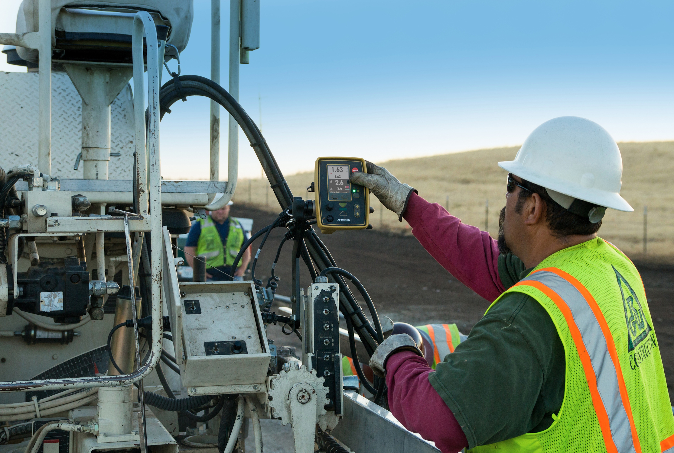
Topcon Positioning Group announces advances to its P-32 asphalt paving system with new components including the ST-3 sonic tracker, anti-vibration slope sensor and a firmware update to the full-color, graphical display GC-35 control box.
“The P-32 paver system was built to improve smoothness, ensure accurate slope and material thickness and provide unmatched operator ease-of-use,” said Kris Maas, machine control product marketing manager. “Announced in 2013, the P-32 saves time and improves safety by allowing an operator to view elevation and slope values of the screed from a single control box. With these new components, this state-of-the-art 2D control system will continue to improve the speed and quality of asphalt paving.”
The ST-3 sonic tracker is designed to enhanced position indication on string lines, give a wider range of linear detection and work better in tight areas. “The introduction of the ST-3 sonic tracker will increase productivity for users by providing smoother surface detections,” said Maas. “The smoother it can be, the faster the job will be finished.”
The new slope sensor to the P-32 system is designed to increase accuracy in the most challenging conditions. “This new slope sensor is amazingly resistant to vibrations and provides stable operation within dynamic temperature ranges,” said Maas.
A firmware upgrade to the GC-35 full-color, graphical display control box provides enhanced slope accuracy data. “The cross slope value will be displayed even when the control box is set in elevation control mode on both sides, which takes the guess work out of knowing whether the cross slope is correct. Additionally, block slope calibration protects users from accidentally changing the slope sensor while the P-32 system is in operation,” said Maas.
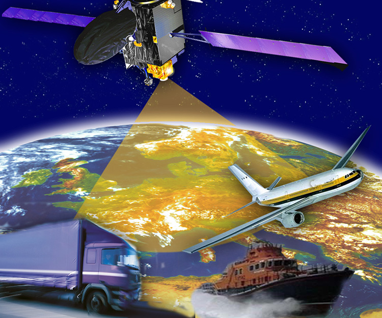
Plans to harness Galileo and other satnav systems for next-generation satellite augmentation systems for aviation and other high-performance uses took a significant step forward at the latest gathering of worldwide operators and experts, reports the European Space Agency.
Satellite augmentation systems combine additional ground stations and satellite transponders to sharpen satnav accuracy and reliability across given geographical regions — based on the U.S. GPS for now, but with plans to move to a multi-constellation design additionally employing Europe’s Galileo, China’s BeiDou, and Russia’s GLONASS systems in the post-2020 era.
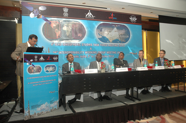
The 26th Satellite Based Augmentation Systems (SBAS) Interoperability Working Group (IWG) took place in New Delhi, India on February 5–7.
The 26th SBAS Interoperability Working Group (IWG) was introduced by V. Somasundaram, board member of the Airport Authority of India.
Among its achievements was to converge on a standard message definition for one of the channels — known as L5 — of the planned second-generation SBAS systems, which will utilize dual-frequency, multi-constellation signals.
“Two solutions had been put forward, one by ESA based on work by European industry and one from the U.S. Federal Aviation Administration and Stanford University,” explains ESA’s Didier Flament, co-chair of the IWG.
“A single definition coordinated between both bodies has been presented, combining the benefits of both solutions. The formal IWG review and approval loop has now been started with the objective of finalizing it for September’s IWG meeting.
“The aim is to have it ready to submit to the official international SBAS standardization bodies — the International Civil Aviation Organization and the Radio Technical Commission for Aeronautics — as soon as October.”
The meeting also marked the significant progress made by Indian’s own SBAS system GAGAN, which underwent its final stability test last summer, followed by its safety certification in December.
At this point GAGAN was declared certified for non-precision approach users , followed by its safety-of-life service being formally offered to civil aviation users on 14 February.
GAGAN has been jointly undertaken by the AAI and the Indian Space Research Organisation, intended to provide improved accuracy, availability and integrity necessary to enable users to rely on satnav signals for all phases of flight – from en route as well as approach to all qualified airports within the GAGAN service area.
SBAS services worldwide
EGNOS is an operational precursor to Europe’s Galileo global satnav system.
GAGAN is the fourth certified SBAS to enter servicer worldwide. Europe has the European Geostationary Navigation Overlay Service (EGNOS), which was designed and built by ESA then turned over for operation by the European Satellite Service Provider, ESSP, overseen by the European Global Navigation Satellite System Agency (GSA) — both of whom also participated in the meeting. ESA retains responsibility for the future evolution of EGNOS.
The U.S. has the Wide Area Augmentation System (WAAS), developed and operated by the Federal Aviation Administration, with an extension over Canada called CWAAS (Canadian WAAS). WAAS celebrated its 10th anniversary of operational life last July.
Japan has the Multi-functional Satellite Augmentation System (MSAS), developed and operated by Japan’s Civil Aviation Bureau. Japan is currently discussing plans to merge this capability with their new home-grown satnav system, QZSS.
Along with GAGAN, the meeting also covered the progress made by the other SBAS systems under definition or development — the Russian SDCM, Chinese SNAS and Korean K-SBAS.
The follow-up IWG meeting is due to take place in September in Tampa, Florida.
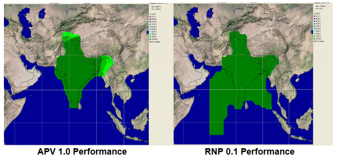
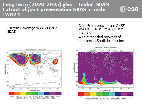
Planned GAGAN service coverage for the two different service levels (RNP0.1 and APV1). GAGAN has been jointly undertaken by the Airport Authority of India and the Indian Space Research Organization, ISRO, to achieve smooth transition to satellite-based navigation and seamless air traffic management across continents. GAGAN is designed to provide improved accuracy, availability and integrity necessary to enable users to rely on GPS for all phases of flight, from en route through approach for all qualified airports within the GAGAN service volume. More precisely it is aimed to provide Non Precision Approach RNP0.1 service levels to the entire Indian Flight Information Region and Precision Approach APV1 service (equivalent to the current EGNOS Service) within a specified service volume within Indian land mass.
Tackling ionospheric interference
The New Delhi IWG took place concurrently with a related meeting, the ICAO’s 4th Ionospheric Study Task Force. This group has been tasked with the objective of developing region-specific models of ionospheric models to compensate for satnav signal interference or loss.
The ionosphere, the electrically sensitive outer shell of Earth’s atmosphere, can be perturbed by solar activity. And because satnav signals pass from space by Earth they can then be disrupted in turn. Equatorial regions see the greatest disturbance, including signal delay or ‘scintillations’ making signals unstable.
The aim is to develop reliable ionospheric models to compensate for these effects, particularly for equatorial SBAS regions, such as India. ESA is contributing with data from its worldwide Monitor network, gathering data to improve future EGNOS performance and potentially support further geographical extension.
Comparing current worldwide SBAS coverage — based on WAAS, EGNOS and MSAS — to the situation envisaged for 2020–25: near-global coverage based on WAAS, EGNOS, MAAS, SDCM and GAGAN, with an expanded network of stations in the southern hemisphere, based on a common dual-frequency/dual satnav standard being finalized by the SBAS IWG.
GeoLearn, a start-up devoted to servicing the geospatial industry with online learning and continuing education credits, has launched its website and training portal with an initial catalog of 22 one-hour-long courses taught by industry-leading faculty members. Course topics available at launch include “Unmanned Aerial Vehicles (UAV’s),” “ALTA/ACSM Land Title Surveys,” and “National Flood Plain Insurance.”
“We want to provide quality professional development to satisfy continuing education requirements that also enables you to deliver services to your clients from a higher quality knowledge base,” said GeoLearn Principal Joe Paiva. “You often have to get continuing education to satisfy licensing requirements; at GeoLearn you will also leave enriched — a plus for any geospatial organization.” While catering to professionals, GeoLearn will begin to build up courses suitable for technicians as well, including a series that supports those pursuing Certified Survey Technician (CST) status.
GeoLearn faculty members are nationally recognized experts in the geospatial field. Initial faculty include Gary Kent of the Schneider Corporation, Wendy Lathrop of Cadastral Consulting and GeoLearn Principal Joseph Paiva. More courses will come soon from other notable professionals in the geospatial industry.
“A key motivation to start GeoLearn has been the desire to significantly improve the learning experience for busy professionals and technicians,” said GeoLearn Principal Bob Morris. “With limited time availability and the growing cost of travel associated with more traditional methods of securing continuing education credits, we hope to provide an attractive option using of state-of-the-art multi-media through our online training portal.”
GeoLearn has invested in a multi-camera video production studio optimized for online learning, and hired Emmy Award-winning marketing and video expert Peter Barrett to head up those efforts.
During this year, National Atlas of the United States and The National Map will transition into a combined single source for geospatial and cartographic information. This transformation is projected to streamline access to maps, data and information from the USGS National Geospatial Program (NGP). The move will prioritize the the agency’s civilian mapping role and consolidate core investments, the agency said.
The USGS will continue its long history of providing topographic maps, geospatial data and other geographic information by offering a range of scales and layers of geospatial information on The National Map Viewer and through US Topo maps. As a result of the conversion to an integrated single source for geospatial and cartographic information, nationalatlas.gov will be removed from service on September 30, 2014.
“We recognize how important it is for citizens to have access to the cartographic and geographic information of our nation. We are committed to providing that access through nationalmap.gov,” said Mark DeMulder, NGP director.
“We value the National Atlas customers and stakeholders and want to make this transition as easy as possible,” explained Jay Donnelly, the National Atlas Program Manager. “We will post updates to The National Map and National Atlas Websites as this transition unfolds, including information on the future availability of the products and services currently delivered by nationalatlas.gov.”
March 6, 2014 update: On March 6, 2014 Federal Judge Patrick Geraghty ruled against the FAA in its case against Rapheal Pirker, opening up commercial use of drones in the U.S.
Forgive me for circling back on the the topic of drone use for commercial mapping in the U.S., but I’m drawn to it like a bee to honey. Perhaps it’s because I used to fly airplanes, or because drone technology encompasses a lot of the technology I’m involved with: GNSS, inertial navigation, GIS, imagery. Be that as it may, the most intriguing aspect of this issue in the U.S. is that seemingly law-abiding citizens are knowingly (or unknowningly) disregarding the Federal Aviation Administration’s (FAA) firm stance that no commercial drone operations are allowed.
According to the FAA, it doesn’t matter if the drone flies under 400 feet. It doesn’t matter if an operator only flies the drone above his/her own property. It doesn’t matter if the drone operator doesn’t charge for the service. If its business-related (such as mapping your fields), it’s illegal, according to the FAA.
But, who cares?
Late last year, Fox News published a story about a farmer in Idaho who uses a drone he built to monitor activities on his farm. According to the report, he’s not waiting around for the FAA “to work out rules for drones.” Countless U.S. start-up companies are promoting their mapping drones by either selling drones (MarcusUAV, Honeycomb, VoltAerial Robotics, Precision Drone, etc.) or selling services to process data collected by drones (such as DroneMapper).
Last week, online magazine Politico published an article appropriately titled “FAA Risks Losing the Drone War.” The article summarizes that as much as the FAA wants to tell you it’s illegal to fly drones commercially, people are doing it anyway. They aren’t sneaking around trying to hide it! High-profile people have openly used drones without regard to the FAA’s opinion. Martin Scorsese reportedly hired a drone service company to shoot one of the scenes in the 2013 movie “The Wolf of Wall Street.”
“Honestly?” said one commercial operator, who requested anonymity to protect his business. “My hope is that I’m far afield enough and small enough potatoes to the FAA that I can fly under the radar on this one.”
I think that’s the most honest statement I’ve read so far, and that’s probably the attitude of nearly every operator who is flying drones commercially in the U.S., even as they attempt to justify how they are legally (or illegally) dancing around the FAA rules.
The FAA has to take the majority of the blame for letting this happen. Perhaps it’s intentional? A “don’t ask, don’t tell” policy? There seem to have been very few enforcement actions taken by the FAA. In November 2013, I requested a list of enforcement actions from the FAA regarding UAVs. Despite giving me delivery dates, nothing has arrived and I’m told I won’t likely see anything from the agency. In an article published by BusinessWeek last week entitled “The FAA Finds Commercial Drone Flights Hard to Police,” BusinessWeek reports that the FAA informed the magazine that it took action “17 times in 13 months ending July.” Furthermore, the article quotes a former FAA employee involved with drones as saying “The reality is, there is no way to patrol it.”
March 3, 2014 Update: On February 26, 2014, the FAA published “Busting Myths about the FAA and Unmanned Aircraft”.
The Mobile World Congress in Barcelona has turned into a mini Consumer Electronics Show. The term “Internet of Things” is the new hot buzz word this year. The show had an estimated 75,000 attendees spread across two sites and eight football-field-sized exhibit halls. While the connected car continued to have high visibility, other technology such as location-enabled advertising and indoor positioning received buzz.
BARCELONA — Fueled by connected car popularity, automakers and vendors converged on the Mobile World Congress here to assess the market in a continent that has not fared well economically. Some say the European market for location products is slower than that of North America — others say it is doing fine.
In this climate, a few automobile analysts have indicated they were worried that a large player such as Google or Apple will swoop in and take control of the connected car market — and tell automakers what to put in a vehicle. Last month, Google even formed its own group, the Open Automobile Alliance, with GM, Honda, Audi, Hyundai and chipmaker Nvidia.
Jorg Brakensiek, Car Connectivity Consortium chair of technical work group and Nokia principal architect, smart devices, doesn’t believe that Google will tell automakers what to do when it comes to connected vehicles. “Android is a consumer electronic device. Completely different than what we do,” he said. “Certainly, there are complimentary applications. We are not dominated by a single partner.”
At MWC, the Car Connectivity Consortium, or CCC, rolled out MirrorLink Developer Fast Track to allow developers to gain MirrorLink certification, an industry standard for car-smartphone interoperability, for their connected car applications. “We believe in standardization of the technology. But also do not put restrictions on business models and feel we allow a very open ecosystem [for members],” Brakensiek said.
Several industry analysts have said that the connected car market will eventually drive the autonomous vehicle movement, also championed by Google. Brakensiek said people still have to make the decisions — driverless cars initially will not be fully autonomous. “People have to make the judgment whether to hit the kid, or drive into a car next to them. Will that decision be made entirely by a car? I hope not,” he said.
CCC said that Coyote, Glympse and Parkopedia are the first developers admitted to the program. CCC said developers will have access to technical support, social media and press inclusion, promotion of the application among members and other benefits.
At an MWC developer’s conference, CCC said that Peugeot Citroen will roll out two MirrorLink-enabled vehicles, the C1 and 108, at the Geneva International Motor Show.
One company, Cincinnati-based RacoWireless, has been working with a number of overseas wireless carriers as well as automakers to power connected vehicles. The company recently signed a deal with AT&T Mobility to connect the Audi A3 line to LTE. As GPS World reported, AT&T had announced its LTE commitment to Audi at CES.
“We want to have our customers get the connectivity they need. We have signed dozens of carriers [worldwide], but now we are looking at more strategic partnerships,” said John Horn, RacoWireless president, who also says the Latin America is a growing market, working with its carrier partner, Telefonica, there.
At MWC, RacoWireless said it would integrate Inmarsat’s M2M service into its Omega Management Suite. The OMS is a cloud-based dashboard that helps to enable RacoWireless’ network of more than 1,000 providers. The deal could be significant as satellite connectivity services, required in remote areas, are growing in the M2M market.
Magellan Boss Outlines Strategic Vision
One of the companies trying to establish deep roots in the connected vehicle market is Magellan. Peggy Fong, Magellan president, said the company’s strategic focus is now in two areas: Wearables and connected vehicles.
“We have set a clear direction for the company in next few years. Our focus will be the cloud connected car, which is not traditional navigation,” she said. “Our other focus will be wearables. We saw that market coming when we identified that [portable navigation device] sales were declining five years ago.”
Magellan’s first foray into the wearable/smartwatch market wasn’t a success. The new product, Echo, was launched at CES, works with a smartphone. “The first product built a foundation. We are focusing on the sports watch market, which is different than the fitness market,” Fong said.
In addition to Magellan’s rollout, Garmin teamed up with Sony at MWC to offer navigation on a smartwatch. The app has speed warnings, traffic tracking, social media capability. The unit, launching later this spring, has a monthly service charge.
Fong believes that navigation on a watch won’t catch on because consumers are already carrying a smartphone with that capability. “We don’t believe navigation is the best use for a watch,” said Fong, who indicated that the company was working on other applications for its own wearable product.
Garmin also is offered its Navigon, Streetpilot navigation units for iPhones, iPad, Android and Windows phones at MWC. Its Head-Up Display Plus was getting a lot of buzz at the Showstoppers event the day before the conference.
Established Location Companies Exhibit at MWC
Telecommunication Systems’ two location entities — one based in California and the other in Washington state — displayed location-based services and navigation systems at MWC.
TCS rolled out its DopplerNav embedded weather overlays at the show. The company is also trying to establish a foothold with European wireless carriers with its Gokivo 2.0 location-based technologies for both Android and iPhone smartphones.
“Users can see real-time weather and be able to adjust routes around it. The released version of the product is scheduled for April, but we are rolling it out in Europe,” said Michael Loo, TCS senior marketing manager, of the new DopplerNav unit.
The company’s Seattle unit, which was made up of former Autodesk employees, is seeing inroads in Latin American markets. Europe, however, has been a tough nut to crack as carriers haven’t signed up for its white label locater product.
“Our Family Locater and Workforce Locator products are doing well in Latin America. We are trying to gain a foothold here in Europe,” said Javier Ferraez, TCS senior product manager, location applications.
Overall, TCS was one of the companies that had been hurt by Google’s free maps and navigation, but is now seeing growth in niche LBS and navigation areas.
Also at MWC, Nokia’s Here unit had a few product announcements such as a mapping product with CNN; Here maps and turn-by-turn navigation integration into the parent company’s first Android-based phone, Nokia X (which doesn’t incorporate Google maps and navigation); Here Auto Cloud that powers Volvo navigation; and even location-based games.
Where’s Indoor Positioning?
Some of the usual industry players had displays on indoor positioning, but there were no big announcements. Such companies as SK Telecom displayed beacons with centimeter-level accuracy that leverage Bluetooth, Wi-Fi and UWB technology.
“We have indoor and outdoor beacons. The outdoor beacons can last three years without a battery change,” said John Kwon, Idolink CEO, who was displaying a system that is not on the market to assess European carriers’ interest.
SK Telecom displayed its augmented reality platform, also not yet on the market, which allows users to point a camera at an object, have it identified, mapped/located and described. The company says it will allow the development of many business-to-business and business-to-consumer augmented reality services and content by third-party developers. This may open the door to several markets such as advertising agencies, education and publishing companies.
In other Mobile World Congress news:
ALK Technologies showed off its free CoPilot GPS app, which has turn-by-turn navigation. The app has a new feature called CommuteMe, which learns a driver’s daily commute routing, tracking streets and freeways they frequently use. ALK was another company that focused on enterprise markets, particularly when Google invaded the market with free maps and navigation.
Is the Mobile World Congress outgrowing Barcelona? Seems as if it is almost as hard to get a hotel room, flight and other travel as it is to the Consumer Electronics Show in Las Vegas. One attendee said he found great lodging near the conference, but obtained it in October. Others in the industry believed that the enormous trade show is getting too expensive — and too far away — to realistically attend and market products and services.
There were many more meeting rooms this year than at previous MWCs. Many companies are opting in on these private venues to talk with customers and potential customers.
Mark Zuckerberg came out in his trademark short sleeved T-shirt and jeans. He promoted Internet.org, an effort to get the web into underdeveloped countries. Of course, he was talking to a room of wireless executives and others who would have to build/pay for that capability. He also said he was done acquiring companies for now — does that mean there will be no $19 billion Whatsapp pay day for a location company?
Last week, the FCC proposed to update 911 regulations to require carriers to be able to locate 911 calls that are made indoors. The current rules were made in 1996 and only required carriers to locate outdoor calls. Then, the outdoor-only rule made sense. We used wireline indoors, and complex indoor technology wasn’t in sight. That is no longer the case. Nearly 73 percent of 911 calls in California are made from wireless phones. The FCC wants to start small; in the near term, wireless carriers would need to identify the building, as well as the floor, from where the call is being made. I’ll get to the proposed long-term rules in a bit.
How do I think this will play out? Dialing back in time to the turn of the century, you will recall that the carriers were stomping their feet in outrage over FCC rules that required carriers to send the location of an outdoor 911 call to dispatch centers. The word onerous was used generously by the carriers. K Street filled its pockets lobbying the FCC to water down location accuracy requirements and reporting. There were certainly some challenges complying with the FCC rules, but they were greatly overstated.
Back then, I served two terms on the board of the E911 Institute, which supported a caucus in Congress devoted to promoting emergency response. The board included wireless carriers, vendors and public safety professionals. While, on the face of it the carriers were providing support for E911, at the same time, they were working hard to take teeth out of the implementation. We will see how the carriers respond this time.
So let’s look at the FCC’s proposed rules for the long-term. The commission is proposing more detailed indoor location accuracy standards that would require identification of the specific room, office or apartment where a wireless 911 call is made. Imagine a call being placed from a college dorm or arena and the value is clear. And with regard to the technology, my retailer in the mall can trace my location throughout the mall, before and after I enter their store. As usual, the commercial arena has showed us what’s possible. Let’s see what the carriers say this time about stricter rules on location.
Carlson Software’s newest data collector, the Carlson MINI2, packs a punch for its compact size. The new handheld computer is taking the place of its predecessor, the Carlson MINI.
With an IP68 rating (better than the original MINI), the MINI2 is waterproof and dustproof, and is tested to MIL-STD-810G to meet the environmental demands of the surveying industry. The MINI2 also has several advancements over the MINI, including a bright display, a custom battery that lasts 20+ hours on one charge, and a scratch-resistant capacitive touchscreen with glove-friendly numeric keypad, for faster and more accurate data entry.
The Carlson MINI2 was designed and manufactured by Juniper Systems, which specializes in building ultra-rugged handheld computers. Juniper Systems also manufactures the Carlson Surveyor handheld computer. Carlson Software packages these rugged handhelds with its own software to provide a total solution for surveying professionals.
“Carlson Software has been a great partner of Juniper Systems for many years now,” said Debbie Trolson, Geomatics Market Manager at Juniper Systems. “Their high level of service as well as their attention to customer needs has made them not only an excellent company, but also a leader in the surveying market. I believe our cooperation with Carlson in providing the MINI2 to surveying professionals will continue to strengthen our partnership for years to come.”
“Working with the team at Juniper Systems has allowed Carlson to offer our customers the kind of rugged and reliable hardware they need out in the field,” said Butch Herter, director of Hardware for Carlson Software. “The Juniper-produced MINI2 and Surveyor are the perfect complement to Carlson’s popular and efficient data collection software choices.”
CompassTools Inc., a distributor of mapping and GIS products for field data collection, has installed a GPS reference station in Durango, Colorado, to provide freely available differential correction data to GPS users in the Four Corners area of Colorado, New Mexico, Utah and Arizona. The correction data can significantly enhance the accuracy of location coordinates captured by GPS receivers used in mapping and surveying applications.
“We have many clients involved in GIS mapping projects for energy development, utility asset location and local government applications in the Four Corners region,” said CompassTools CEO Steve Chiles. “CompassTools set up the Durango reference station to help them complete their mapping projects with greater efficiency and accuracy and at less expense.”
CompassTools is a value-added reseller of hardware and software mapping solutions from Trimble, Laser Technology, Ricoh, GeoSpatial Experts, Esri, and CartoPac. Since 1994, CompassTools has sold, leased, repaired, and offered training on the latest GPS and GIS mapping products in an eight-state region that includes Colorado, Wyoming, New Mexico, Minnesota, Nebraska, the Dakotas and parts of Texas. In addition, the firm provides expert GPS/GIS consulting and creates customized bundled packages to meet the specific needs of complex data collection projects.
The Trimble NetR9 GNSS reference station installed by CompassTools in Durango is capable of receiving location signals from GPS, GLONASS, and Galileo. CompassTools established the unit as a Continuously Operating Reference Station (CORS) accepted by the National Geodetic Survey (NGS) and part of Mesa County Colorado’s Real Time Virtual Reference Network.
“The Trimble NetR9 broadcasts differential correction data in real time via a cellular signal,” said Chiles. “And the correction data is also posted automatically to the CompassTools website for post-processing.”
Chiles explained that this means the GPS user has the option — usually depending on the capabilities of their portable GPS receiver — to correct their location data and improve its accuracy in real time as they collect it in the field. Or the GPS user can download the correction data from the CompassTools website when they return to the office and process the data after the fact. An advantage of real-time correction is the user knows the accuracy of the GPS data being collected while still in the field.
“The ultimate accuracy of the collected location data depends on the quality of GPS receiver being used,” said Chiles. “We have many clients in Durango using mapping-grade handheld GPS data collection devices achieving accuracy better than 10 centimeters using the reference station data.”
Honeywell Aerospace’s LASEREF VI navigation system has been selected by Airbus Helicopters for its light helicopter platforms, the EC145 T2 and EC645 T2 family.
The LASEREF inertial reference unit (IRU) allows helicopter operators to always have an autonomous navigation source available in the absence of a GNSS and radio navigation. The capability is especially useful when navigating during a mission when the GNSS is unavailable due to terrain masking, limited satellite constellation availability, or unintentional or intentional jamming.
“LASEREF will provide Airbus Helicopters with exactly what they’re looking for — an always-available and highly reliable navigation system,” said Varant Panossian, customer business manager at Honeywell Aerospace. “When you’re in extreme situations, navigation is essential for everything from crew safety to completing critical missions.”
Designed for fixed-wing and rotary-wing applications, the LASEREF is a light, small IRU that delivers the highest reliability in the industry, according to Honeywell. Its integration with GPS prevents delays in information delivery and keeps operations running safely and efficiently even under harsh environments and demanding mission situations.