Category: Applications

  • Next-Generation Clock Increases Stability to 300 Picoseconds

    Next-Generation Clock Increases Stability to 300 Picoseconds

    Personnel with the U.S. Naval Observatory-Detachment Colorado and 2nd Space Operations Squadron move the rubidium fountain clock into its new home Tuesday at Schriever Air Force Base. The USNO monitors the GPS constellation and provides time offsets to the 2nd Space Operations Squadron for their daily navigation uploads to each individual GPS satellite. (U.S. Air Force photo/Christopher DeWitt).
    Personnel with the U.S. Naval Observatory-Detachment Colorado and 2nd Space Operations Squadron move the rubidium fountain clock into its new home Tuesday at Schriever Air Force Base. The USNO monitors the GPS constellation and provides time offsets to the 2nd Space Operations Squadron for their daily navigation uploads to each individual GPS satellite. (U.S. Air Force photo/Christopher DeWitt).

    The U.S. Naval Observatory’s Alternate Master Clock on Schriever Air Force Base received its second rubidium fountain clock February 4 to ensure it has the most precise time in the world.

    Both the USNO’s Washington D.C.-based primary and its local Alternate Master Clock facility serve as the Department of Defense’s common time reference. Additionally, the USNO monitors the GPS constellation and provides time offsets to the 2nd Space Operations Squadron for its daily navigation uploads to each individual GPS satellite.

    “With the new rubidium fountain clock, we are going from the time standard of 1 to 2 nanoseconds down to 300 picoseconds,” said Bill Bollwerk, Head of USNO Detachment Colorado.

    One nanosecond is equivalent to one billionth of a second, while a picosecond is equal to one trillionth of a second. Though these small slices of time may not sound important, every nth of a second is significant, especially in GPS operations.

    “A nanosecond matters because it is equivalent to a 1-foot of error for GPS,” Bollwerk said. “If the GPS satellite clocks were off by 3 nanoseconds, you have 1-meter of error introduced into GPS.”

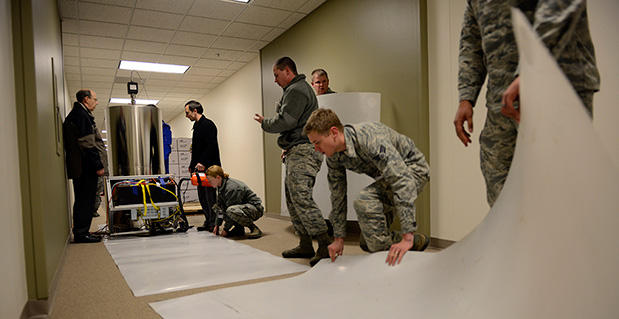
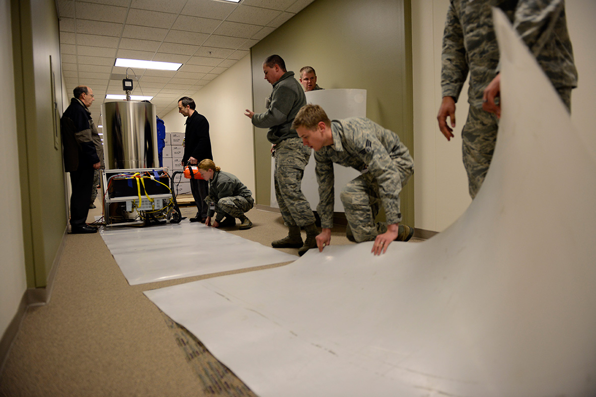
    Designed and produced by physicists at the USNO laboratory in Washington D.C., the powered rubidium fountain clock traveled by dedicated truck to Schriever. Once the fountain clock arrived at Colorado base, with the help of members of the 2nd Space Operations Squadron, the 50th Security Forces Squadron and 50th Civil Engineering Squadron, the USNO team moved it to a climate controlled chamber in the USNO’s laboratory via an airsled hover lifter.

    “The 2 SOPS men and women are able to operate and provide accurate instantaneous reliable support to U.S. military forces around the world, thanks to our partnership with the U.S. Naval Observatory,” said Lt. Col. Thomas Ste. Marie, 2 SOPS commander. “We are happy to be able to work together to support their upgrade. Our relationship allows 2 SOPS to continually reach our goal of record breaking time-transfer performance and navigation accuracies.”

    Although 2 SOPS was happy to support the move, it’s not as easy as one might think.

    “The process of moving the rubidium fountain was very complicated,” said Ken Dreiling, USNO Detachment Colorado. “We had to ensure the fountain clock was not actually in contact with the floor or the walls as we moved it from the loading dock through the hallways and elevator into our facility.”

    The careful transport of the fountain was essential to prevent damage that could affect the clock’s performance.

    “The fountain clock collects billions of rubidium atoms, encased in a spherical vacuum chamber and laser-cooled to a millionth of a degree above absolute zero degrees Kelvin, approaching the coldest temperature anything can be,” Bollwerk said. “The reason we do that is because we want to observe and measure the atoms for long time in an environment that minimizes unwanted noise like the Doppler Shift.”

    Though the Alternate Master Clock provides precise timing for several communication and space systems, Missile Defense Agency, DOD facilities and several civilian infrastructures around the world, the new system was installed primarily to support GPS operations.

    “It is great to have the most precise time standard in the world but it is useless unless you can get it to the user, not everyone can come to the facility and set their watch,” said Bollwerk. “GPS is USNO’s primary means of providing global precise time to the warfighter. It is a great partnership between the Navy and the Air Force.”

    Dreiling said the new fountain clock will help improve GPS operations.

    “The new rubidium fountain clock is the next-generation new frequency standard,” Dreiling said. “This will boost the GPS’s timing by 10-fold.”


  • Jackson Labs Delivers Low Phase-Noise Frequency and Timing Reference

    Jackson Labs Delivers Low Phase-Noise Frequency and Timing Reference

    The DROR-II by Jackson Labs.
    The DROR-II by Jackson Labs.

    Jackson Labs Technologies, Inc., a designer and manufacturer of GPS, timing and frequency equipment, is offering the DROR-II, a 10-MHz/5-MHz/1-PPS GPS-Disciplined Atomic Frequency and Timing Reference (GPSDO).

    The DROR-II is a ruggedized frequency and timing reference with a Cesium Vapor Atomic Oscillator followed by a precision SC-cut Crystal Double-Oven Oscillator and an actively vibration-compensated VCXO oscillator, with specific emphasis on ultra low phase noise performance under extreme vibration and acceleration such as could be encountered in aircraft, tracked vehicles, and wheeled vehicles.

    The DROR-II unit is optimized for operation in high-vibration and high-acceleration environments that require ultra-low phase noise performance and high frequency stability under extreme conditions. The DROR-II combines the strengths of three different on-board oscillators to provide an overall performance that has not been achievable with legacy products, at a steady-state power consumption of less than 3.85W, the company said.

    The DROR-II uses a GPS receiver to provide long-term phase and frequency accuracy of the built-in CSAC atomic oscillator which is followed by an SC-cut, Double Oven OCXO (DOCXO) for very high short-term stability and low phase noise, which is itself followed by a three-axis electronically vibration-compensated crystal oscillator for ultra-low-noise under high vibration. Using these four signal sources cascaded to each other allows unmatched Phase Noise and Short Term Stability (ADEV) while also providing long-term atomic holdover, very fast warmup, and long-term phase-lock to UTC. Short term stability of 1E-012 (1ppt), and phase noise floors of -162dBc/Hz are achieved. Frequency stability over 24 hours is better than 5E-013 (0.5ppt) typically when locked to GPS.

    The DROR-II supplies three isolated 10-MHz Sine Wave outputs, two CMOS 1PPS, and one 5-MHz output that is phase-synchronized to UTC via the internal GPS receiver. DROR-II contains a 50-channel WAAS/EGNOS/MSAS-enabled GPS receiver that provides support for avionics systems through integrated three-axis gyro-accelerometers and a -160-dBm GPS tracking capability. DROR-II power requirements are less than 3.85W steady-state, and only a single supply of between 11.0V to 32V is required. Support for an external LCD display is standard.

    The unit can be monitored and controlled by an RS-232 port or a USB port via industry standard SCPI-99 Commands (GPIB commands), and is capable of generating numerous NMEA-0183 output sentences for easy integration into existing infrastructure. The DROR-II can be ordered with various OCXO options and with different temperature ranges.

  • u-blox Introduces 3D Automotive Dead Reckoning

    u-blox Introduces 3D Automotive Dead Reckoning

    The u-blox ADR chip.
    The u-blox ADR chip.

    u-blox has introduced its next-generation semiconductor technology dedicated to advanced in-dash navigation, emergency call (including eCall, a European rapid response initiative, and ERA-GLONASS, Russia’s Government Accident Emergency Response System), usage-based insurance, road-pricing, and stolen-vehicle recovery systems.

    The UBX-M8030-Kx-DR chip integrates 3D Automotive Dead Reckoning (3D ADR) technology, which enables it to calculate a vehicle’s position, speed, and elevation in areas of poor or no satellite visibility, a common scenario in high-density urban environments, stacked highways, or parking garages.

    Here is a two-minute YouTube video demonstration.

    “Drivers expect car navigation systems to be fast, accurate, and work everywhere, regardless of satellite visibility. As cities expand, construction of more tunnels, multi-level overpasses and park garages is increasing,” said Thomas Nigg, VP Product Marketing at u‑blox. “Our solution meets this challenge head-on; regardless of satellite visibility, our 3D ADR chip shows movement in three dimensions to maintain continuous and accurate positioning in tunnels, stacked highways, multi-level or underground parking facilities.”

    The technology aids traditional GNSS navigation systems such as GPS, GLONASS and BeiDou by blending them with individual wheel speed, gyroscope and accelerometer information to maintain accurate 3D positioning even when satellite signals are completely lost.

    The UBX-M8030-Kx-DR chip is self-calibrating to compensate for sensor aging and temperature effects. It is compatible with virtually all vehicles and drive trains (i.e. front-, rear-, all-wheel drive), and supports a variety of sensor combinations. Sensor information can be derived from the vehicle’s sensors for the most cost-efficient implementation, or from external sensors for after-market solutions.  The chip is AEC-Q100 qualified and is produced in ISO/TS Automotive certified production sites.

    The chip requires minimum host integration or customization resulting in no risk, low cost, and fast time-to-market, u-blox said. Installation is uncritical thanks to automated software calibration. 3D ADR is accurate even at low speeds.

    The chip allows for easy testing, simple and modular production set-up, and minimal BOM. The chip comes in a 40-pin QFN package measuring only 5 x 5 mm and includes I2C, SPI, UART and USB interfaces.

  • Centimeter-Level RTK Accuracy More and More Available — for Less and Less

    Eric Gakstatter
    Eric Gakstatter

    Last month, I started off 2014 with a bang by listing all the public RTK bases available in the United States, most of them being free. I received a lot of positive feedback and some enlightenment. For example, I didn’t know that in California, there are more than 330 RTK public base stations accessible by anyone for free via the California Real Time Network website at the University of California at San Diego! What a tremendous resource for California surveyors and GISers.

    Remember that RTK will give you 1-2 cm accuracy horizontally and twice that for vertical. If you know that and also know that there are 330 free RTK bases in California, why would anyone use post-processing for high-precision (e.g., sub-foot) GIS data collection? RTK technology used to be reserved for people who could spend tens of thousands of dollars on a GNSS receiver. Not any longer. RTK receivers are available for under $7,000, and you don’t need to invest in a RTK base unit if you’re in range of a public one on my list (or a commercial one not on my list).

    I’m pretty sure it was Charlie Trimble (founder of Trimble Navigation) who said “accuracy is addictive.” It sure is. Once you experience real-time centimeter-level accuracy (RTK) in the field, you won’t be satisfied with anything less, and neither will your GIS.

    I’ll keep updating the List of Public RTK Base Stations in the U.S. as people continue to inform me of ones that aren’t on my list. If you know of one, please email me.

    Keeping on the subject of RTK, 2014 might be the year of inexpensive RTK receivers. Whereas today you can find L1/L2 GNSS RTK receivers (in the U.S.) ranging from US$6,500 to US$25,000, there are rumors that some manufacturers are going to break through the US$6,500 price point.

    This is in line with the prediction I made a few years ago, but for a different reason. In 2010, I wrote that RTK receivers would become very inexpensive due to the new L5 signal being introduced, which would increase competition among GNSS receiver designers. I speculated that with more competition, the selling prices would significantly decline. Well, we are still without a usable L5 signal (although making progress) due to the slow deployment of modernized GPS satellites and the delay in Europe’s Galileo system, but we are still seeing a steady decline in the price of RTK receivers. Why is this?

    Even though there are a limited number of designers of RTK GNSS receivers, an increasing number of companies are buying RTK GNSS boards from these designers and making their own finished RTK GNSS receivers that look and perform very similar to receivers available today, for a fraction of the price. This is especially true in China, where there are several manufacturers buying RTK GNSS receiver boards from Trimble, Novatel, Hemisphere et al, making their own finished products and selling them. They were initially selling to very price-sensitive markets such as Africa, but now you see them setting up distribution in North America.

    This “OEM Syndrome” has put tremendous price pressure on existing brand-name RTK GNSS receivers as the Chinese-equivalent products are priced as little as 25% of the equivalent brand-name products. Of course, this drives the leading brand-name companies crazy. They are forced to either drop their price or otherwise convince buyers that their products are worth a significant premium. During these times of tight capital budgets, it’s increasingly difficult to do the latter. When enough satellites are in orbit broadcasting the L5 signal, you’ll really see this effect gain traction because there will be a lot more RTK GNSS designs to choose from, and the result will be better quality. More competition always results in better product quality and performance.

    The fact is that RTK receivers are moving towards becoming a commodity. As much as your local salesperson would like you to think they are selling a better RTK GNSS receiver, the technology gap between leading-brand designers and others is closing and probably unnoticeable to most of you. The major differences end up being the quality and reliability of the finished product (system design, battery, display, antenna integration, power supply, etc.). Having a great RTK GNSS receiver board inside is useless if the system design is unreliable.

    More Real-time PPP Competition

    For the longest time, it’s only been OmniStar (now owned by Trimble) and Starfire (owned by Deere & Co.) in the L-band high-precision correction game. Then, last year, the International GNSS Service announced its free decimeter real-time PPP service.  The catch is that receiver designers must incorporate IGS firmware to make use of the signal and…it’s only an Internet-based service (no satellite communications).

    In the past couple of months, Hexagon (which owns both Leica and Novatel), made a bid for Veripos. Veripos operates an L-band GNSS correction service for the oil and gas industry. Last year, TerraStar, a subsidiary of Veripos, announced its new decimeter service that is very similar to OmniStar and Starfire. It uses satellite communications for a data link. Altus Positioning Systems incorporated the TerraStar service into its receivers. Hexagon is very close to closing the deal with Veripos and just last week announced a partnership with competitor Topcon Positioning Systems. The result is that Leica and Topcon both will start offering high-precision L-band GNSS correction services with their receivers. If you’re an L-band decimeter user, this is probably good news for you. More competition = higher quality and lower price.

    Thanks, and see you next month.

    Follow me on Twitter at https://twitter.com/GPSGIS_Eric

  • Juniper Systems’ Archer Field PC Records Elevation of Remote Himalayan Peak

    Juniper Systems’ Archer Field PC Records Elevation of Remote Himalayan Peak

    Juniper_Archer_on_Mountain
    Photo credit: Mark Fisher at www.fishercreative.com, Instagram: @fishercreative; via Juniper.

    Juniper Systems’ Archer Field PC has beenused to record the elevation of a never-before-climbed peak in the remote Myanmar Himalaya. The peak, Mount Gamlang Razi, has historically been known as the second highest peak in Southeast Asia, but a joint American-Myanmar-led expedition set out on a mission last September to hopefully prove that it is in fact the tallest. Read the whole story on Juniper Systems’ blog.

    Standing at a reported 5,881 meters tall, Mount Hkakabo Razi has long been known as Southeast Asia’s highest peak. In recent years, however, the legitimacy of the elevation of Hkakabo Razi has come into question. Current digital analysis suggests that initial surveys of Mount Hkakabo Razi were overstated and its actual elevation is as much as 100 meters lower than originally believed. At the same time, digital analysis suggests that virgin-peak Gamlang Razi may in fact be the taller peak. This controversy prompted Idaho resident and experienced climber Andy Tyson to lead an American-Myanmar expedition team on a three-week approach through 150 miles of cobra-riddled, mosquito-infested jungle, and from there up to the peak of Gamlang Razi to measure its elevation in person.

    Tyson needed a device that could accurately record the elevation at the summit, while being able to withstand the extreme conditions of the hot, wet jungle and the frozen mountaintop. With this in mind, Tyson requested from Juniper Systems a top-of-the-line rugged handheld. In response, Juniper Systems provided the team with an Archer Field PC with Hemisphere GPS XF101 receiver, along with training to record the GPS data they needed.

    Setting up the Archer Field PC to collect GPS data. Photo credit: Mark Fisher at http://www.fishercreative.com. Instagram: @fishercreative
    Setting up the Archer Field PC to collect GPS data. Photo credit: Mark Fisher at http://www.fishercreative.com/Instagram: @fishercreative/via Juniper.

    After a 35-day journey, Tyson and the team successfully summited Gamlang Razi, with the Archer Field PC in hand. After collecting GPS data at the top, the data was sent via satellite phone to Juniper Systems for analysis. After post-processing the data against terrestrial base stations in Lhasa, Tibet, and confirming the results with Effigis in Montreal, Canada, Juniper Systems concluded that the elevation of Gamlang Razi was 5,870 meters, ±2 meters. This suggests that Gamlang Razi is taller than nearby Hkakabo Razi by approximately 112 meters and should be considered Southeast Asia’s new highest peak.

    However, there are many — particularly natives to Myanmar — who are not ready to accept changes to Hkakabo Razi’s original elevation measurement. This was made apparent in a letter Myanmar’s president, Thein Sein, wrote to Tyson and the team after their successful summit, congratulating them for summiting Southeast Asia’s second-tallest peak.

    Tyson remains firm in his assertion that Gamlang Razi is the country’s highest peak, but some have suggested that the debate may not be over until someone actually climbs Hkakabo Razi and measures it in person. Juniper Systems said they have a handheld for the job, should that time come.

    The expedition team. Photo credit: Mark Fisher at http://www.fishercreative.com. Instagram: @fishercreative
    The expedition team. Photo credit: Mark Fisher at http://www.fishercreative.com. Instagram: @fishercreative/via Juniper.
  • Samsung Connects Fans with Sochi Olympic Games App

    Samsung Connects Fans with Sochi Olympic Games App

    Olympics-Wow-Curling
    screenshot: Wireless Olympic Works (WOW)

    The Sochi 2014 Olympic Winter Games mobile app, Wireless Olympic Works (WOW), turns the world’s Android devices into mobile sports stations that fans can use to personalize their own Olympic Winter Games experience, according to maker Samsung Electronics.

    The XXII Olympic Winter Games, held in Sochi, Russia, run February 7-21.

    Fans attending the Olympic Winter Games in Sochi will have access to a location-based Olympic Winter Games venue guide through the Samsung WOW technology. The guide offers Olympic venue information and navigation services so visitors can feel truly integrated into the Olympic Winter Games experience on the ground, Samsung said.

    Samsung’s Public WOW app also provides sports fans with real-time access to event schedules, latest reports on results, medal standings and Olympic records. Public WOW is an extension of Samsung’s custom WOW for the Olympic Family, which is a wireless communications platform developed to ensure smarter communications and smoother, wireless operations of the Olympic Winter Games by offering news and information about the games to officials and staffs.

    “Samsung is offering fans around the world the most direct access to Sochi 2014 Olympic Winter Games and allowing them to design and personalize their experience in ways that are most relevant to their interests and passions,” said WS Lee, senior vice president of New Business Development, Mobile Communications Division at Samsung Electronics. “Our dedicated teams are hard at work year-round to ensure that the WOW technology is ready for use throughout the Games, both for consumers looking for the ultimate Olympic Winter Games experience, and for the Olympic Family utilizing our technology to support Games-time operations.”

    All Android users worldwide can download Samsung’s Public WOW app via the Samsung App store and Google Play.

    Components of the Samsung WOW app allow fans to design their own Olympic Winter Games experience in the following ways:

    Personalize an Olympic Winter Games updates plan. highly personalized, live Games-time updates ranging from medal counts to big moments that can be pushed to users’ phones in real time. A new cheering service will allow fans to send cheers to support their favorite athletes and countries.

    Share celebrations with social network features. Users can upload text and images instantly to share with other WOW app users and with their social networks, creating a global community around shared interests in the Olympic Winter Games and winter sports. Languages supported for the Public WOW app include Chinese, English, French, German, Korean, Russian and Spanish.

    Learn about Olympic sports with an interactive, visual guide. The app offers information on all 15 winter sports at Sochi 2014 through a highly visual and engaging graphic user interface. A Visual Sports Guide will provide tutorials on each sport, including rules, equipment details and many other points of interest bring people closer to the excitement of the Olympic Winter Games.

    “With its advanced technology in wireless communications, Samsung has played an essential role in the successful operation of the Olympic Winter Games. We believe the WOW app for Sochi 2014 will once again benefit the Games with more efficient and faster communications for the Olympic Family as well as fans around the world” said Timo Lumme, managing director, IOC TMS.

    As part of the “Samsung Smart Olympic Games Initiative,” Samsung will provide around 18,000 mobile devices to the Olympic Family, including executives, staff, and officials from the IOC, National Olympic Committees and organizing committees in Sochi. They will be connected to Samsung’s WOW service which will provide essential, up-to-date Games Time data and connectivity that is crucial to the Olympic Winter Games operation.

    The Samsung WOW service was first launched during the Athens 2004 Olympic Games for the Olympic Family and has since evolved into a must-have resource for officials, attendees and fans worldwide.

    Samsung began its Olympic Games involvement as a local sponsor of the Seoul 1988 Olympic Games. Beginning with the Nagano 1998 Olympic Winter Games, the company extended its commitment to the Olympic Movement as the Worldwide Olympic Partner in the Wireless Communications Equipment category, providing its proprietary wireless communications platform, called Wireless Olympic Works (WOW), and mobile phones. These mobile phone technologies provide the Olympic Family with real-time, user location-based information service and interactive communications. Samsung’s commitment as a Worldwide Olympic Partner continues through to Rio 2016.

  • U.S. DoT to Move Ahead with Vehicle-to-Vehicle Communication Technology

    U.S. DoT to Move Ahead with Vehicle-to-Vehicle Communication Technology

    Connected vehicles can help to mitigate crashes on busy urban streets.
    Connected vehicles can help to mitigate crashes on busy urban streets.

    The U.S. Department of Transportation’s (DOT) National Highway Traffic Safety Administration (NHTSA) announced today that it will begin taking steps to enable vehicle-to-vehicle (V2V) communication technology for light vehicles. This technology would improve safety by allowing vehicles to “talk” to each other and ultimately avoid many crashes altogether by exchanging basic safety data, such as speed and position, ten times per second, the agency said.

    “Vehicle-to-vehicle technology represents the next generation of auto safety improvements, building on the life-saving achievements we’ve already seen with safety belts and air bags,” said U.S. Transportation Secretary Anthony Foxx. “By helping drivers avoid crashes, this technology will play a key role in improving the way people get where they need to go while ensuring that the U.S. remains the leader in the global automotive industry.”

    DOT research indicates that safety applications using V2V technology can address a large majority of crashes involving two or more motor vehicles. With safety data such as speed and location flowing from nearby vehicles, vehicles can identify risks and provide drivers with warnings to avoid other vehicles in common crash types such as rear-end, lane change, and intersection crashes. These safety applications have been demonstrated with everyday drivers under both real-world and controlled test conditions.

    The safety applications being developed provide warnings to drivers so that they can prevent imminent collisions, but do not automatically operate any vehicle systems, such as braking or steering. NHTSA is also considering future actions on active safety technologies that rely on on-board sensors. Those technologies are eventually expected to blend with the V2V technology. NHTSA issued an Interim Statement of Policy in 2013 explaining its approach to these various streams of innovation. In addition to enhancing safety, these future applications and technologies could help drivers to conserve fuel and save time.

    V2V technology does not involve exchanging or recording personal information or tracking vehicle movements. The information sent between vehicles does not identify those vehicles, but merely contains basic safety data. In fact, the system as contemplated contains several layers of security and privacy protection to ensure that vehicles can rely on messages sent from other vehicles and that a vehicle or group of vehicles would be identifiable through defined procedures only if there is a need to fix a safety problem.

    In August 2012, DOT launched the Safety Pilot “model deployment” in Ann Arbor, Michigan, where nearly 3,000 vehicles were deployed in the largest-ever road test of V2V technology. DOT testing is indicating interoperability of V2V technology among products from different vehicle manufacturers and suppliers and has demonstrated that they work in real-world environments.

    In driver clinics conducted by the Department prior to the model deployment, the technology showed high favorability ratings and levels of customer acceptance. Participants indicated they would like to have V2V safety features on their personal vehicle.

    “V2V crash avoidance technology has game-changing potential to significantly reduce the number of crashes, injuries and deaths on our nation’s roads,” said NHTSA Acting Administrator David Friedman. “Decades from now, it’s likely we’ll look back at this time period as one in which the historical arc of transportation safety considerably changed for the better, similar to the introduction of standards for seat belts, airbags, and electronic stability control technology.”

    NHTSA is now finalizing its analysis of the data gathered as part of its year-long pilot program and will publish a research report on V2V communication technology for public comment in the coming weeks. The report will include analysis of the Department’s research findings in several key areas including technical feasibility, privacy and security, and preliminary estimates on costs and safety benefits. NHTSA will then begin working on a regulatory proposal that would require V2V devices in new vehicles in a future year, consistent with applicable legal requirements, Executive Orders, and guidance. DOT believes that the signal this announcement sends to the market will significantly enhance development of this technology and pave the way for market penetration of V2V safety applications.

    “We are pleased with the direction NHTSA is taking in terms of V2V technology,” said Greg Winfree, Assistant Secretary for Research and Technology. “The decision to move forward comes after years of dedicated research into the overwhelming safety benefits provided by a connected vehicle environment.”

    V2V communications can provide the vehicle and driver with 360-degree situational awareness to address additional crash situations — including those, for example, in which a driver needs to decide if it is safe to pass on a two-lane road (potential head-on collision), make a left turn across the path of oncoming traffic, or in which a vehicle approaching at an intersection appears to be on a collision course. In those situations, V2V communications can detect threats hundreds of yards from other vehicles that cannot be seen, often in situations in which on-board sensors alone cannot detect the threat.

    NHTSA has worked in close partnership in this research both with other DOT agencies, including the Office of the Assistant Secretary for Research and Technology and the Federal Highway Administration, and with several leading auto manufacturers and academic research institutions, who have invested significant resources into developing and testing V2V technology. The collaboration of government, industry and academia is critical to ensure V2V technology’s interoperability across vehicles.

    Find more more information on the Department’s vehicle-to-vehicle communication technology research.

  • $2.6 Billion GPS Fitness Device Market Overshadowed by Smart Devices and Wearables

    ​Despite major GPS fitness device OEMs announcing new fitness products at January’s International Consumer Electronics Show in Las Vegas, it looks like an increasingly difficult battle between smart devices and wearables, according to analysts at ABI Research.

    Garmin launched its Vivofit fitness band and Vivoki/Vivahub corporate wellness solution. Magallen is one of the few companies in the GPS device OEM space that continues to show flashes of innovation, opening up its Echo watch platform to a range of third-party smartphone application developers.

    At the high-end of the GPS fitness watch market, Polar has launched a new multi-sport watch, which features a barometric pressure sensor, support for new features such as a cycling power pedal. TomTom has launched an iOS application that links its current GPS watch range to an iPhone via Bluetooth.

    In ABI Research’s quarterly GPS/GNSS Device tracker, the impact of these new device categories on dedicated GPS fitness device growth can be fully seen. Senior analyst Patrick Connolly comments, “Our forecasts for the overall GPS-enabled fitness area remain strong, hitting $2.6 Billion in 2018, but as was the case with turn-by-turn navigation, converged devices and wearables will take an increasing part of the available market. The adage of keeping what we have is important here, retaining a firm eye on growth in professional users, with hardware and in particular eyewear, a major distinguisher.”

    Practice director Dominique Bonte adds, “Of the announcements, Garmin’s move into corporate wellness was the most striking. We are about to see a huge technological shift in the corporate/business sector, around BYOD, BYOW, wellness, security, and efficiency. What is interesting is that Garmin does not include a location element, which will be a core enabler in this sea change.”

    The findings are part of ABI Research’s Location Devices Research Service.

  • New DX-200 Expands Robotic Working Range, Features Hybrid Versatility

    New DX-200 Expands Robotic Working Range, Features Hybrid Versatility

    DX_200_Application_Sok_1D64Sokkia Corporation is offering enhanced abilities and versatility to its DX series of total stations with the introduction of the DX-200 in the North American market.

    When configured for hybrid positioning, the DX-200 has the ability to use both GNSS positioning and optical positioning data simultaneously. The standard Sokkia Hybrid Robotic System includes the DX, GRX2 GNSS receiver and MESA large-screen tablet controller.

    “The DX-200 is ideal for the professional looking for a mid-range, auto-pointing total station that can become a full-robotic instrument with a simple firmware upgrade,” said Ray Kerwin, director of global surveying products. “Advanced functionality such as hybrid positioning can be added to the robotic unit, making the DX-200 a versatile system for multiple applications.”

    The DX-200 can be used with the RC-PR5 remote controller for increased Bluetooth wireless operating range. “The remote allows for rapid prism search and lock up to 2,000 feet (600 meters) away,” Kerwin said.

    “Hybrid positioning adds a new dimension of versatility,” Kerwin said. “When line-of-sight is blocked, for example, shots can be measured with the GNSS receiver, and the receiver can also be used for quick lock functionality.”

    Standard additional features of the DX series include Direct Aiming auto-collimation technology, TSshield security and maintenance technology, MAGNET integrated software onboard and Sokkia’s patented RED-tech reflectorless measurement system.

    The DX-200 is available in 1, 3 and 5 arc second accuracy models.

  • Exelis Reaches GPS OCX Milestones for Navigation and Encryption Software

    GPS-OCX-Logo-TExelis has successfully completed several software upgrades for the new Global Positioning System Next Generation Operational Control System, or GPS OCX.  Integration and testing were recently conducted on iteration 1.5 of the OCX navigation, encryption and Mission Upload Generator, or MUG, software.

    The new version of GPS software will help ground controllers better understand the satellites’ exact positioning in space. The encryption software is also designed to automatically code and decode GPS signals, facilitating the exchange of user information by securely transmitting navigation payload data between the OCX ground system and the orbiting constellation of satellites.

    The MUG software is responsible for creating spacecraft payload updates to refresh the navigation data transmitted to all GPS users. This data is typically generated for each satellite multiple times a day and  helps to consistently minimize user error.

    “These software milestones demonstrate a clear path to improved GPS accuracy and integrity,” said Drew Trainor, OCX program manager for Exelis Geospatial Systems. “Civilian and military users will have more accurate and secure GPS signals, and these milestones bring us one step closer to GPS modernization.”

    Under a February 2010 contract award from Raytheon, Exelis is providing software that will simulate the behavior of GPS signals in space. In addition, Exelis is building high-precision receivers for use in ground monitoring stations placed strategically around the world. Exelis is also providing data encryptors that help ensure secure information exchange between the ground and space segments of the system.

    Once the new operational control segment is implemented, GPS will improve a variety of business and economic practices, including air traffic control, crop management, and environmental monitoring, among others. The new capabilities offered by GPS modernization will also provide military users increased accuracy, availability, anti-jam power and international interoperability.

  • Telenav Acquires skobbler to Tap into ‘Wikipedia of Maps’

    Telenav Acquires skobbler to Tap into ‘Wikipedia of Maps’

    skobbler_logoTelenav, Inc., announced today that it has acquired skobbler GmbH, the European-based navigation company with the highest rated OpenStreetMap (OSM)-based GPS navigation apps in the world. With this acquisition, Telenav brings the most successful OSM navigation experts in the world together as one team — including the founder of OSM, Steve Coast, who joined Telenav in 2013 — and becomes a major contributor to the creation of the open-sourced and most comprehensive map of the world, according to the announcement.

    The acquisition closed on January 29 for consideration of approximately $19.2 million in cash and $4.6 million of company common stock.

    “Crowdsourced OSM can power personalized navigation services like Scout — with highly detailed maps on a global scale,” said HP Jin, Telenav’s chairman and CEO. “We plan to offer Scout with OSM for much of the world. We have already made significant headway toward this goal in the U.S., including using OSM for our HTML5 version of Scout.”

    OSM is the only crowdsourced and open-sourced map of the globe and, for many developers, it has become a clear alternative to Google Maps.

    “Waze and Google — or, just Google now — provide similar mechanisms to improve their maps, based mostly on OSM’s innovations. With one big catch. It is very much their map. Not yours,” said Coast in his blog commentary today regarding the acquisition. “OpenStreetMap is different. All of the quality data contributed is openly available — just like Wikipedia. So, anyone can download, experiment and play with it freely. It’s not locked up beyond your reach.”

    Since Coast founded OSM, the community has doubled year over year to more than 1.5 million registered editors, becoming a global community of local editors in every corner of the world. Its crowdsourced model publishes edits every minute on openstreetmap.org, resulting in maps that are detailed and up to date. For example, newly laid streets and newly developed areas can be updated on a regular basis and in real time. In addition, OSM allows for greater map detail for pedestrians such as alleys, sidewalks, parks, hiking trails, zoos, and even city trees.

    Telenav has been an active contributor to OSM for more than three years, working closely with the community to enhance specific features needed for navigation, traffic and other future location-based services.

    With offices in Germany and Romania, skobbler was the first company to launch a commercial navigation app using OSM (in 2010) for both Android and iOS devices and is available in app stores in 49 regions with worldwide map coverage. In order to do this, skobbler developed sophisticated algorithms that evolved OSM data from a display map to a navigable map.

    skobbler’s apps are top ranked and highly rated in multiple countries including Germany, the Netherlands, and Sweden. skobbler’s CEO, Peter Scheufen, previously served as the CEO of Navigon, which became a leading GPS device manufacturer in Europe and was eventually purchased by Garmin. The other skobbler founders also held senior roles at Navigon before founding skobbler. Telenav expects that all skobbler employees will join Telenav as part of its OSM team, bringing significant industry-leading software expertise in location-based services, navigation and mapping.

    “By joining our efforts with skobbler, we will build on our combined successes to bring the best mapping and navigation services to our customers around the world,” said Jin. “The benefits of an open source model will provide an enormous opportunity to change the economic models of navigation and other location-based services.”

    “OSM is currently one of the most active and dynamic crowdsourcing communities and is growing at an explosive rate,” said Scheufen. “Our team lives and breathes OSM and so we are excited to join forces with Telenav to create the largest, most sophisticated, and smartest OSM navigation team in the world.”

    In connection with the acquisition and in accordance with NASDAQ Marketplace Rule 5635(c), Telenav granted four employees of skobbler and its subsidiaries, upon the closing of the acquisition, restricted stock units for an aggregate of 634,920 shares of common stock.

    These RSUs were granted outside of the existing Telenav stock plans and without stockholder approval pursuant to NASDAQ Marketplace Rule 5635(c)(4) with the following terms: each RSU vests as to 50% of the award on the anniversary of Acquisition and as to 50% of the award on the second anniversary of the Acquisition, subject to continued employment through each relevant date.

  • Telenav Acquires skobbler to Tap into the ‘Wikipedia of Maps’

    skobbler_logoTelenav, Inc., announced today that it has acquired skobbler GmbH, the European-based navigation company with the highest rated OpenStreetMap (OSM)-based GPS navigation apps in the world. With this acquisition, Telenav brings the most successful OSM navigation experts in the world together as one team — including the founder of OSM, Steve Coast, who joined Telenav in 2013 — and becomes a major contributor to the creation of the open-sourced and most comprehensive map of the world, according to the announcement.

    The acquisition closed on January 29 for consideration of approximately $19.2 million in cash and $4.6 million of company common stock.

    “Crowdsourced OSM can power personalized navigation services like Scout — with highly detailed maps on a global scale,” said HP Jin, Telenav’s chairman and CEO. “We plan to offer Scout with OSM for much of the world. We have already made significant headway toward this goal in the U.S., including using OSM for our HTML5 version of Scout.”

    OSM is the only crowdsourced and open-sourced map of the globe and, for many developers, it has become a clear alternative to Google Maps.

    “Waze and Google — or, just Google now — provide similar mechanisms to improve their maps, based mostly on OSM’s innovations. With one big catch. It is very much their map. Not yours,” said Coast in his blog commentary today regarding the acquisition. “OpenStreetMap is different. All of the quality data contributed is openly available — just like Wikipedia. So, anyone can download, experiment and play with it freely. It’s not locked up beyond your reach.”

    Since Coast founded OSM, the community has doubled year over year to more than 1.5 million registered editors, becoming a global community of local editors in every corner of the world. Its crowdsourced model publishes edits every minute on openstreetmap.org, resulting in maps that are detailed and up to date. For example, newly laid streets and newly developed areas can be updated on a regular basis and in real time. In addition, OSM allows for greater map detail for pedestrians such as alleys, sidewalks, parks, hiking trails, zoos, and even city trees.

    Telenav has been an active contributor to OSM for more than three years, working closely with the community to enhance specific features needed for navigation, traffic and other future location-based services.

    With offices in Germany and Romania, skobbler was the first company to launch a commercial navigation app using OSM (in 2010) for both Android and iOS devices and is available in app stores in 49 regions with worldwide map coverage. In order to do this, skobbler developed sophisticated algorithms that evolved OSM data from a display map to a navigable map.

    skobbler’s apps are top ranked and highly rated in multiple countries including Germany, the Netherlands, and Sweden. skobbler’s CEO, Peter Scheufen, previously served as the CEO of Navigon, which became a leading GPS device manufacturer in Europe and was eventually purchased by Garmin. The other skobbler founders also held senior roles at Navigon before founding skobbler. Telenav expects that all skobbler employees will join Telenav as part of its OSM team, bringing significant industry-leading software expertise in location-based services, navigation and mapping.

    “By joining our efforts with skobbler, we will build on our combined successes to bring the best mapping and navigation services to our customers around the world,” said Jin. “The benefits of an open source model will provide an enormous opportunity to change the economic models of navigation and other location-based services.”

    “OSM is currently one of the most active and dynamic crowdsourcing communities and is growing at an explosive rate,” said Scheufen. “Our team lives and breathes OSM and so we are excited to join forces with Telenav to create the largest, most sophisticated, and smartest OSM navigation team in the world.”

    In connection with the acquisition and in accordance with NASDAQ Marketplace Rule 5635(c), Telenav granted four employees of skobbler and its subsidiaries, upon the closing of the acquisition, restricted stock units for an aggregate of 634,920 shares of common stock.

    These RSUs were granted outside of the existing Telenav stock plans and without stockholder approval pursuant to NASDAQ Marketplace Rule 5635(c)(4) with the following terms: each RSU vests as to 50% of the award on the anniversary of Acquisition and as to 50% of the award on the second anniversary of the Acquisition, subject to continued employment through each relevant date.