Category: Applications

  • NNG Provides Connected Navigation Software to Mazda3

    NNG Provides Connected Navigation Software to Mazda3

    Mazda3's infotainment system.
    Mazda3’s infotainment system.

    The new Mazda3 infotainment system, which appears in Mazda3’s Active Driving Display, is now running on NNG’s iGO navigation engine, and includes TTS, voice recognition and full 3D navigation.

    This solution, supported by Mazda’s MZD Connect, is also reportedly the first on the market to offer an embedded connected-service package with Internet connection provided through the driver’s smartphone. Drivers will be able to access dynamic local search, fuel prices, real-time traffic and weather information free of charge in the first 60 days, and benefit from three years of free map updates.

    “Mazda’s new design, KODO, has really inspired us to develop an integrated infotainment system, with knowledge and refined features matching the look and performance of the car,” said Péter Balogh, NNG. “We succeeded in offering cutting-edge solutions in the head unit, enhanced safety, usability and comfort to the driver.”

  • Hyundai Selects Verizon for Next-Generation Connected Cars

    Hyundai Motor America has selected Verizon Enterprise Solutions to provide a range of connected services including safety, security, diagnostics and infotainment to Hyundai vehicles starting in 2014.

    “We selected Verizon to provide the wireless network service for ‘Next-generation Blue Link’ because both customer opinion and various data sources indicate that Verizon provides the best solution to our customers for both coverage and quality,” said Woo-Young Kwak of Hyundai Motor Group.

    Hyundai vehicles are distributed throughout the United States by Hyundai Motor America and are sold and serviced through more than 820 dealerships nationwide. According to Forrester Research, the number of vehicles shipped worldwide with embedded connectivity is expected to grow from 5.4 million in 2012 to 36 million in 2018.

    “Our agreement with Hyundai expands our long-standing collaboration with a wide range of auto manufacturers throughout the industry to support network engineering, security, cloud solutions, telematics platform, and program management for millions of vehicles in the U.S. and around the world,” said Mark Bartolomeo of Verizon Enterprise Solutions. “We are thrilled to be working with Hyundai to help enhance the driving experience for their customers. It’s the breadth of our expertise combined with the depth of our technology that allows our clients to launch new services and initiatives faster.”

  • AT&T, Sabre to Explore How Location Can Personalize Travel

    AT&T, Sabre to Explore How Location Can Personalize Travel

    sabreAT&T and Sabre, a global travel technology company, announced they will jointly explore solutions that could usher in a more personalized experience for travelers. The two companies are developing and testing solutions that will utilize AT&T’s newly enhanced Location Information Services (LIS) – Hybrid, which allows developers to build geo-aware mobile applications. The companies are exploring how device-based location information services can help airlines, airport retailers, and other travel-related companies deliver intelligent, predictive and personalized services throughout a traveler’s journey.

    AT&T LIS Hybrid has the ability to define custom geofences (a virtual perimeter within a geographic area) in any shape or size, both indoors and out, using cellular, GPS and Wi-Fi information shared by the user from their devices. Knowing when a traveler enters or leaves a pre-defined geofence would allow travel suppliers to provide personalized services and relevant offers based on the traveler’s real-time location.

    “By applying cutting-edge technologies, coupled with data analytics and better intelligence, we can give travelers the personalized experience they have come to expect in today’s connected world,” said Sarah Kennedy of Sabre Labs, the technology incubator and research lab at Sabre. “Together with AT&T, we will explore the role advanced location-based services can have in helping travel suppliers provide better, more personal service to their customers.”

    The app might alert airline staff when a high-status passenger is still clearing security when her flight is due to depart; or notifies travelers of special promotions as they approach an airport bookstore; or warns a passenger if he is in the wrong terminal for his connecting flight. The two companies are exploring technology that could underpin these types of apps across almost all types of smartphones, tablets and operating systems. Any services developed as part of the trial will meet location services best practices guidelines when it comes to customer privacy including customer opt-in.

    “Our application programming interface, or API, and software development kit allows companies like Sabre to build multi-carrier geo-aware mobile applications,” said Laura Merling, of AT&T. “AT&T LIS Hybrid works with Wi-Fi as well as existing cellular device-based information location services such as GPS, to deliver near-precise device location information indoors and outdoors.”

    Phase one of the pilot project between Sabre and AT&T is expected to be completed during the first half of 2014.

  • Record Number of Automakers at International CES

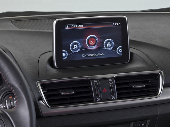
    It’s a daunting task — trying to find the big location story in a maze of 150,000 attendees and thousands of exhibitors at the International Consumer Electronics Show in Las Vegas. Aside from every automaker touting their connected vehicle efforts, the big deal this year at CES is wearable technology (last year it was 3D printing? Yawn). Despite sore feet from walking football-field lengths of booths, CES is still a cool show, blaring stereos, walls of TV screens, robots…and connected cars. 

    LAS VEGAS — Although the largest number of worldwide auto manufacturers attended this year’s International CES here, many industry experts believe that technology giants Google and Apple will swoop in and grab not only the market, but will control what will go into the connected automobile in the future.

    “Leading IT, consumer electronics and Internet companies will marginalize specialist vendors. I’m worried that Internet companies will take over the [connected car] market — away from the auto manufacturers,” said Thilo Koslowski, Gartner vice president at the Consumer Telematics Show, held the day before CES

    Koslowski’s fears have been partially validated as Google launched a partnership, called the Open Automotive Alliance, with automakers to bring the Android operating system into cars. The Google move comes after a similar announcement by Apple, which was launched to get its iOS platform into connected cars.

    Initial Open Automotive Alliance members include Audi, General Motors, Honda, Hyundai and Nvidia. Apple, in its group, has Jaguar Land Rover, Volvo, Mercedes-Benz, Honda, Ferrari, Nissan, Chevrolet, Infinity, Kia, Hyundai, Opel and Acura.

    “We think [Google] is a strong content partner — the deal gives [you] perspective on where we as a company are heading. Same on the Apple side,” said Charles Koch, Honda manager, new business development, at the Consumer Telematics Show.

    Despite standing room-only crowds at CES during most of the connected and automated car session, Koslowski said companies need to keep the right focus on the future. “[Connected vehicles] still are not a definite market, but we will see if it is in the next 3-4 years,” he said. “HMI and user interface will be biggest differentiators. Personalization will be important, but it will also be an expected feature.”

    Koslowski said the Holy Grail for connected vehicles in the future is the transition to autonomous capability. “It’s progressing very quickly. Automakers have to avoid the gold rush mentality as it may not be the treasure trove,” he said.  “They have to meet expectations [about the the technology] and avoid the creepiness factor that you know too much about the consumer.”

    Regardless of the future, Koslowski believes the connected vehicle is a disruptive opportunity.  “I can see carriers offering a car for free in exchange for lifetime data. Less dramatic would be with an eight-year data plan,” he said. “This would probably be a smaller, less expensive vehicle than a Ferrari or Audi.”

    Overall, the telematics market has gone through several market changes in the past 10 years, said Kevin Link, senior vice president and general manager, China, for Verizon Telematics.  Link said that Telematics 1.0 included door unlock, navigation, automatic collision notification, call centers and navigation. “It all began with GM and Mercedes becoming springboards for the industry. Initially, there was low consumer awareness; now, it is something like 88 percent in the United States,” he said.

    Outside the U.S., however, the consumer awareness for telematics drops into the single digits. “The business model, especially in the U.S., is a burden on the consumer. In China, it’s a business-to-business play, which is not a burden on the consumer, which also explains the high usage rate,” Link said.

    At CES, a record nine automakers attended and exhibited:  Audi, BMW, Chrysler, Ford, General Motors, Kia, Mazda, Mercedes and Toyota.

    AT&T Mobility Makes Big Announcements at CES

    In a pre-CES press conference, General Motors announced its first LTE-enabled vehicles — in which AT&T Mobility is powering the LTE network for GM’s OnStar service. The first LTE-enabled vehicles, which will be available this summer, are Impala, Spark, Volt, Orlando, Spark RV, Silverado, Silverado HD, Malibu, Equinox and Corvette Stingray.

    AT&T also announced it will provide connectivity for Ericsson Connected Vehicle Cloud which connects to the AT&T Drive platform for automakers

    “We expect about 50 million cars to be connected by 2020. The car will be another device in your life,” said Glenn Lurie, AT&T president, emerging enterprises and partnerships. “LTE in a car will get another set of application developers involved — how will they differentiate the car?  It’s a global opportunity.”

    Magellan and Navigation Solutions’ Nav System Features Proximity Capability

    Navigation Solutions, owned by Hertz, said it is working with Magellan to offer the NeverLost 6 navigation device that features connected services — many of which offer a consumer choices based on businesses and attractions near their current location.

    A number of new systems, including Magellan’s new models and Pioneer’s five NEX models, which consist of four navigation and an A/V receiver, feature connected services that allow access to navigation — even when the phone isn’t connected to a data source. This has been a sore subject for users of the free Google Maps on a phone — no Internet, no navigation.

    Magellan also announced a new line of RoadMate Personal Navigation Device (PND) units featuring Easy Touch screens and an underlying Android OS to improve navigation capabilities and features.

    In other CES news:

    • Broadcom continues to make strides in indoor and Wi-Fi position with several new product rollouts. The company also is rolling out its BCM47531 GNSS chip that can grab signals from five satellite constellations at the same time (GPS, GLONASS, QZSS, SBAS and BeiDou), said Mohamed Awad, Broadcom director, product marketing.
    • Alpine rolled out the aftermarket’s first 9-inch navigation system, which will cost $2,600 and be available in June.  The company is targeting used trucks and other vehicles as they are staying on the road longer, said Melvin Diaz, Alpine product planning manager.
    • In its press conference at CES, Kenwood said its navigation units are selling well.  Its flagship, a $1,500, 7-inch system, features INRIX traffic and Garmin navigation.
    • In the LBS Insider February blog, several industry experts will be interviewed about the future of the autonomous vehicle.
  • Esri Publishes Interactive Map of World University Rankings 2013-2014

    In association with Times Higher Education, Esri published an interactive map of world university rankings for the school year 2013-2014. Click on the image below to view the map.

    WorldUniversity

  • Topcon Unveils 2D, 3D Excavator Control Systems

    Topcon Unveils 2D, 3D Excavator Control Systems

    X-32_studio_Topcon-W

    Topcon Positioning Group announces the addition of two new indicate control systems to its excavator control system lineup — the X-32 and X-33. The systems feature Topcon’s new GX-30 control box and TS-i3 sensors.

    The GX-30 features a full-color touchscreen display. The TS-i3 sensors have no moving components, offer single and dual-axis measurement modes, and include convenient LED status indicators.

    “The X-32 is a versatile and easy-to-use 2D excavator system that includes technology not available on other, more expensive systems,” said Kris Maas, manager for machine control product marketing.

    X-32_cab_Topcon-W“The X-32 is an excavator grade indication system to fit any budget. With this new system, you have the flexibility to use a wide array of references from which to work: Existing surface, a hub, previous cut, single slopes and dual slopes with the use of a compass or rotating laser. It’s as easy as choosing your reference and entering a cut and/or slope depth,” Maas said.

    “The X-32 allows an operator to work faster, with consistency and greater degree of accuracy, and promotes a safer work site by keeping a grade checker out of the trench.”

    Additionally, Maas said, “The X-32 grows as your needs expand because it’s easily upgradeable to a 3D system.”

    “The X-33 adds Topcon’s industry-leading GNSS satellite technology to create a highly productive 3D indicate excavator grade control system,” Maas said. The system’s MC-i3 GNSS receiver with Vanguard technology provides “maximum flexibility in satellite signal tracking.  Additionally, the MC-i3 is Sitelink3D ‘ready’ for integration into Topcon’s real-time 3D management solution,” he said.

    The new 3D system is designed to establish grade faster and ensure the operator stays on grade. “The system eliminates over excavation and controls material usage, allowing the user to ‘see’ the exact position of the machine on site and the bucket position at all times,” Maas said. When detailed information is required, the operator can select to visualize the plan, profile, or sectional view and use the dual grade indicators for elevation control.

  • Epson Teams with Geodetics for Inertial Navigation Systems

    Epson Teams with Geodetics for Inertial Navigation Systems

    EpsonIMUEpson Electronics America has announced a strategic partnership with Geodetics Incorporated of San Diego, California, for production of a new variant of its Geo-iNAV product.

    According to the announcement, Geo-iNAV is a fully-integrated GPS-aided inertial navigation system that provides real-time, high-precision positioning and navigation for manned and unmanned air, sea and ground vehicles. It combines GPS and proprietary sensor fusion technologies to achieve centimeter-level real-time positioning and navigation for dynamic platforms. Geodetics will offer Geo-iNAV integrated with Epson’s new G362 and G352 IMU modules. The G362 and G352 are the world’s highest performance IMUs on the market in their size, weight and power class, the company said.

    “Geodetics has the high-precision navigation expertise necessary to integrate IMU and GPS technologies, producing Inertial Navigation Systems (INS) that meet the performance requirements of very demanding applications,” said David Gaber, EEA’s IMU product line manager. “The combined solution, called Geo-iNAV Tactical, is a cost-effective, tactical-grade INS in a compact package with no EAR or ITAR export control restrictions.”

    Geodetics President and CEO Lydia Bock added, “Epson has established a new benchmark for MEMS IMU performance, enabling Geodetics’ products to reach new applications and customers by delivering high performance for a significantly lower cost than competing devices.”

    Epson says that with recent advances in unmanned vehicle technologies, the GNSS ecosystem has expanded to support mission-critical applications, which require more accurate navigation. Geo-iNAV Tactical delivers this capability with  features to support reliable and precise navigation with a low SWaP (size, weight and power) profile for autonomous vehicles and payloads on manned vehicles. Geo-iNAV Tactical is offered in several configurations designed to meet a wide range of requirements and is available in commercial as well as SAASM configurations.

  • Saelig Introduces Low-Cost SMD Antennas

    Saelig Introduces Low-Cost SMD Antennas

    Saelig-proant-W

    Saelig Company, Inc., announces the availability of the Proant OnBoard SMD 2400 (2.4GHz band) and SMD GPS (GPS and GLONASS) miniature surface-mount (SMD) antennas for mobile wireless products. The OnBoard series moves embedded antenna integration one step ahead by combining high performance and low cost in this new OnBoard SMD family, the company said.

    Traditionally, small low-cost antennas for printed circuit board assembly have been manufactured with a dielectric substrate as the base for the radiating structure. With this approach, the antenna is normally a rectangular block, which means that the PCB area below the antenna is unavailable for mounting other components. Another drawback is that the substrate itself introduces dielectric losses to the antenna, reducing its total efficiency.

    Proant has taken the concept of small SMD antennas one step ahead by increasing both the antenna performance and design flexibility, and combining this with low cost and manufacturability. The result is the new OnBoard SMD antenna family, which builds on previous OnBoard antennas, but in a surface mounted sheet-metal solution, packaged in tape-on-reel and suitable for high volume manufacturing. One of OnBoard’s key features, which eliminates the need of the dielectric substrate used in other SMD antennas, is the patent-pending capacitively-loaded footprint of the antenna’s supporting pins, which significantly reduces losses and increases the performance.

    The first two products to be launched in this 50 ohm RoHS-compliant family are OnBoard SMD 2400 (2.4GHz band) and SMD GPS (GPS and GLONASS). Future variants will include WLAN dual-band, 868/915 MHz, and GSM versions.

    “We wanted to simplify antenna integration for our customers,” said Tomas Rutfors, CEO of Proant. “The solution was to make a simple product that satisfies both engineering and sourcing needs. With the OnBoard SMD family, we have defined a new product segment, which didn’t exist before.”

    Made in Sweden by Proant AB, a widely respected specialist antenna company in the M2M and wireless market, providing a wide range of embedded and external antennas, OnBoard SMD 2400 (2.4GHz band) and SMD GPS (GPS and Glonass) are available now at under $1 (1000 pcs) from Saelig Company, Inc., the USA technical distributor. A demonstration board is also available at $35.

  • Garmin Introduces GPSMAP 64 Series Outdoor Handheld

    Garmin Introduces GPSMAP 64 Series Outdoor Handheld

    Garmin's GPSMAP 64 device.
    Garmin’s GPSMAP 64 device.

    Garmin International Inc., a unit of Garmin Ltd., today announced the GPSMAP 64 series of rugged outdoor handhelds. The GPSMAP 64 series brings a dual GPS and GLONASS receiver, preloaded geocaches and smartphone connectivity for LiveTrack and Smart Notification to its product line for hikers, hunters, and geocachers.

    “Building on the popularity of the GPSMAP series, the new GPSMAP 64 series improves functionality to make a top-notch device even better,” said Dan Bartel, Garmin vice president of worldwide sales. “The GPSMAP 64 is ideal for anyone, no matter if it’s their first handheld, or if they’ve used Garmin for years. It combines trusted Garmin technology with the comfort of a device people know and love.”

    The GPSMAP 64 series has a 2.6-inch sunlight-readable transflective color display and a high-sensitivity GPS and GLONASS receiver with a quad helix antenna for superior reception. With the addition of GLONASS satellites, the time it takes for the receiver to lock on to a position is (on average) approximately 20 percent faster than using GPS alone. This allows users to get their position quickly and precisely even in heavy cover and deep canyon.

    The GPSMAP 64 series features three distinct water-resistant (IPX7) models to suit various activities and interests. The basic GPSMAP 64 includes a built-in worldwide basemap with shaded relief, and supports BirdsEye Satellite imagery and TOPO U.S. 24K maps. The GPSMAP 64s adds a 3-axis electronic compass and barometric altimeter. Additionally, the 64s adds wireless connectivity for data transfer between other compatible Garmin handhelds and mobile apps, and for Smart Notification technology. With this, users can receive emails, texts and alerts on the device (when paired with an iPhone 4S and later). This allows users’ smartphones to be safely protected from the elements. The 64s also comes with a one-year subscription of BirdsEye Satellite Imagery. The GPSMAP 64st includes preloaded U.S. 100K topographic maps. With this, users will be able to search for points of interest by name or proximity to their location and view descriptive details for terrain contours, topo elevations, summits and geographical points.

    For outdoor adventurers, the rugged GPSMAP 64 devices are compatible with BaseCamp, a free software download that allows users to view and organize maps, waypoints, routes and tracks. The 64s and 64st models are compatible with the BaseCamp mobile app for data transfer, and the Garmin Connect mobile app, for features such as LiveTrack. With LiveTrack, users can pair their device with the app, and invite friends and family to follow their activity in real time. This provides peace of mind, especially if users are alone. Through ANT+, the 64s and 64st models are also compatible with external sensors such as an external temperature sensor and heart rate monitor. With ANT+, the 64s and 64st models can act as a remote for the new VIRB and VIRB Elite action cameras.

    Each device comes preloaded with the locations of 250,000 geocaches from Geocaching.com. Devices store and display key information to find the hidden containers including the geocache coordinates, terrain rating, its difficulty, hints and descriptions, so users no longer have to manually enter coordinates or print out geocache info. By going paperless, users are helping the environment, and improving their efficiency. If users would like to continue geocaching beyond the preloaded geocaches, when they register their device they can sign up for the free premium membership trial through Geocaching.com, and download more geocaches. The GPSMAP 64 devices can store millions more, so users will no longer have to pick and choose which geocaches they want to load on their device.

    All of the devices in the GPSMAP 64 series have a dual-battery system, where both standard AA batteries and a rechargeable NiMH battery pack (sold separately) can be used. The devices have internal memory (4GB for 64/64s and 8GB for 64st), and a microSD card slot to store additional data and maps.

    The new GPSMAP 64 series will be available this month. The GPSMAP 64 will retail for $299.99, the GPSMAP 64s will retail for $399.99, and the GPSMAP 64st will retail for $499.99.

  • Honda Joins Google Alliance to Develop GPS Solutions

    Honda Motor Co. is joining an alliance of companies that will work with Google Inc. on technological innovations for inboard automotive information networks, such as GPS, according to The Asahi Shimbun. Honda will be joining Audi AG, General Motors, and Hyundai Motor Group in the Open Automotive Alliance. The alliance plans to incorporate Google’s Android operating system into automotive communications systems.

    Google has also indicated interest in the development of driverless cars.

    Toyota Motor Corp., meanwhile, established a joint venture with Microsoft Corp. three years ago to develop information technology for Toyota’s next-generation vehicles. The technology allows for updating map data and other services for the GPS in Toyota vehicles, as well as track stolen vehicles.

  • CHC Offers GNSS Post-Processing Software

    CHC Offers GNSS Post-Processing Software

    CGO Software-CHC

    CHC announced today the availability of CHC Geomatics Office (CGO), a software solution dedicated to post processing static and kinematic GNSS raw data. CGO supports GPS+GLONASS+BeiDou data in various raw data formats and is compatible with major brands, allowing a seamless integration with an existing pool of equipment, the company said.

    “CGO is undoubtedly the most affordable yet powerful GNSS post processing software available in the market.” says George Zhao, CEO of CHC. “In addition, this new product launch reinforces our commitment to provide full GNSS solutions to our customers including post-processing applications.”

    A 90-day fully functional demonstration license is available to enable users to evaluate the CGO’s features before purchasing.

    CHC designs, manufactures and markets a wide range of professional GPS/GNSS solutions in more than 50 countries. Headquartered in Shanghai (China), CHC is a GPS/GNSS manufacturer with a strong international presence and employs more than 500 professionals worldwide.

  • Parsec Antennas Designed for Telit Mini GPS Receiver

    Parsec Antennas Designed for Telit Mini GPS Receiver

    Telit Wireless Solutions and Parsec Technologies today announced that a combination of the companies’ technologies results in a low profile  companion solution for GPS receiver and antenna. For host devices able to accommodate higher volumetric symmetry, assembly of the components can be made to fit a 6 x 16 x 8 millimeter volume. A flat component arrangement can yield an ultra-low-profile volume of 6 x 16  x 2.4 millimeters.

    ParsecTelitFig1 OBD“Receivers combining the Parsec PTA/PT Family and Telit’s Jupiter SE880 modules deliver good user experience in finished LBS (location-based services) critical products without sacrificing design flexibility, ease of implementation or cost,” said Michael A. Neenan, CEO and founder of Parsec Technologies, Inc. “The combination is ‘bullet-proof’ in providing a rewarding design experience making RF work reliably, passing end-product regulatory compliance testing without re-test.”

    “Miniaturization is a major enabler of new application areas for positioning and M2M,” said Taneli Tuurnala, Vice President and Head of GNSS Division of Telit Wireless Solutions. “With the Parsec antennas, the complete receiver features the industry’s ‘smallest landed footprint,’ making it suitable for use in wearable electronics, UBI devices or adapters for the mobile computing industry.”

    Along with miniaturization, the receiver outperforms top traditional designs, handling a loss of 10 dB or greater in GPS signal reaching, for example, the typical OBD port under a vehicle’s dashboard where many usage-based insurance (UBI) dataloggers are installed. The PTA1.5M active antenna delivers the ultra-sensitive Jupiter SE880 micro receiver over 15 dB of additional gain in the operating frequency range. Both companies are making available complete application notes to simplify the engineering effort for system integrators.

    The miniature 4.7 x 4.7 millimeter LGA (Land Grid Array), SiRFstarIV-based Jupiter SE880 receiver module employs heterogeneous 3D integrated technology to achieve best-in-class performance in all dimensions critical for regular or size-constrained GPS applications. Its RF front-end employs spatially calibrated waveguide-quality radio paths inside the three-dimensional space of its architecture, reducing parasitic impedances characteristic of traditional 2-D RF designs. Inside, a multi-filter system includes not only the traditional SAW filters typical in GPS receiver designs but also a 2.4-GHz notch-filter capable of nullifying the jamming effects of high-energy radio devices such as Wi-Fi hot-spots, Bluetooth systems, cordless phones, and others, which greatly affect a GPS receiver’s ability to resolve timid satellite signals in the hostile radio environment where they need to operate.

    The PTA1.5M, with a gain of 15dB, and PTA1.5x2M, with a gain of 30dB, are tiny GNSS active antenna modules capable of receiving signals down to -192 dBm with frequency centered at 1575.42 (±1.023) MHz. Either model delivers a radiated efficiency greater than 60% when mated to the Jupiter SE880 receiver. Parsec’s PT1233D LNA also has the highest available IP3 at low voltage, helping eliminate interference. Both PTA1.5M and PTA1.5x2M can incorporate the antenna element, an optional SAW filter, the cascadable PT1233D LNA, matching and passives components, on a low cost, easy to integrate 10×16 mm single sided PCBA with “back side” copper clad ground plane. The height of the PTA1.5M and PTA1.5x2M modules vary according to application, allowing their use in even the smallest form factors including Intel’s M.2 Next Generation Form Factor (NGFF) module (23x30x2.4 mm, LxWxH).