Category: Applications

  • Avenza’s PDF Maps App Launches on Google Play Store

    Avenza' PDF Maps app is now available at the Google Play Store.
    Avenza’ PDF Maps app is now available at the Google Play Store.

    Avenza Systems Inc., producers of MAPublisher cartographic software for Adobe Illustrator and Geographic Imager geospatial tools for Adobe Photoshop, announce that PDF Maps app is now available on the Google Play Store.  The first and only geospatial PDF and GeoTIFF reader for Android devices, Avenza said, the PDF Maps app is unique to the space due to its extensive collection of more than 100,000 detailed maps sourced from well-established publishers, cartographers, government agencies and aficionados of outdoor recreational activities, all of which are downloadable directly from within the app.

    PDF Maps take advantage of geospatial technology that allows consumers to view maps and measure real world distances and areas. Paired together with mobile devices that use GPS such as Androids, the PDF Maps app provides constant access to geographic locations and even points of interest without the risk of losing reception due to cell tower proximity.

    Designed with its audience of travelers and outdoor enthusiasts in mind, Avenza’s PDF Maps app has already garnered accolades from the International Map Industry Association (IMIA) and Geospatial World for its innovative use of technology on the iOS platform in 2011 and 2012.  Since then, its versatility for recreational or business purposes out in the field has been recognized across several industries and it’s gaining momentum.

    “The market is currently saturated with map apps that are limited in map data, or too simplified to be functional for offline navigating.  We wanted to address those issues by providing a free navigational app that catered to a segment of users who needed something more substantial than the average turn-by-turn digital maps offered today, while providing map-publishers with an iTunes-like environment for distributing their maps direct to devices” said Ted Florence, President of Avenza Systems Inc.

    “With Avenza’s PDF Maps app Android users can do more than just view their location.  PDF Maps provides a meaningful interface to measure distances, drop placemarks and share personal recorded data in various formats.  It’s more than just a viewing tool, but will provide the Android market the best of both worlds — access to maps from well-known paper map publishers that work in tandem with the functionality of GPS devices.  We’re thrilled to finally make it available to a new market.”

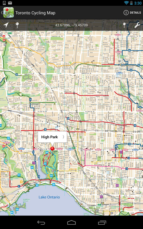
    Unlike other map apps that provide one view of a location using GPS coordinates as most maps do, Avenza’s PDF Maps app expands a traveler’s choices, allowing them to access detailed geography or points of interest created by specific map publishers for use on land, sea or air.  PDF Maps app for Android allows consumers to access information while at a destination, providing users an opportunity to make the most of their time experiencing their environment rather than searching for cell reception to access directions.

    Currently, Avenza’s vast PDF Maps app library covers maps for domestic and international travel organized by state and area.  Android users will appreciate the breadth of tool management features available.  All maps — free and purchased — are accessible through the in-app map store and offer the following capabilities:

    • Add maps from the file system, Dropbox, a URL, email, or Map Store
    • Browse, purchase, and download maps from the Avenza Map Store (existing iOS PDF Maps accounts are compatible)”
    • Show GPS position on maps
    • Add Placemarks
    • Import and export KML
    • Find Coordinates
    • Measure Distance or Area
    • Open current view in Google Maps

    Avenza’s PDF Maps in-app Map Store features a variety of publishers that focus on recreational activities as well as all segments of the map-use market.  Below is a small sampling of maps available:

    • Camping and hiking including National Park Service maps and other regions of the world
    • Nautical and marine navigation including NOAA and FAA charts for North America and other regions of the world
    • Topographic use including USGS and Canadian Topographic maps and other regions of the world
    • Maps for tourists, transit, travel, special events, historic and much more

    PDF Maps is available now in the Google Play Store free of charge. For more information about PDF Maps, visit the Avenza website at www.avenza.com/pdf-maps. Pricing of each map is set by the publisher and free maps remain free to users through the PDF Maps app in-app store.

  • Compass4Colorado Offers GIS Info to Aid Colorado Flood Recovery

    Compass4ColoradoLogoThe Compass family of geospatial companies has established Compass4Colorado, a collaborative effort to make high-tech GIS and mapping capabilities available at no or low cost to organizations involved in the recovery activities related to the devastating Colorado floods. Free flood-mapping webinars and workshops will be offered starting in October.

    Compass4Colorado offers mapping software, integration services, training and expertise at no charge and equipment rentals at significantly reduced rates to public- and private-sector organizations engaged in flood assessment and recovery. The Compass4Colorado campaign will remain active through March 31, 2014, with support from four additional Colorado companies – Trimble Navigation of Westminster, Laser Technology of Centennial, DigitalGlobe of Longmont, GeoSpatial Experts of Thornton – and Esri of Redlands, California.

    “Companies, utilities, and government agencies across Colorado and Nebraska are faced with assessing the full extent of flood damage as recovery begins,” said W. Brant Howard, Founder and Chairman of CompassTools. “We believe that geospatial technologies, especially mobile field data collection, can help this assessment phase proceed more quickly and accurately so the impacted communities can rebuild sooner.”

    Before the flood waters had begun to recede, the Compass companies were taking urgent calls from local municipalities and utilities that needed to survey high-water lines, delineate inundation zones, and photo-map damaged assets. CompassTools found that many organizations requesting assistance with assessment activities had some in-house GPS or GIS capabilities, but they required software upgrades, equipment integration or personnel training to deploy them effectively.

    “If a Colorado or Nebraska organization in the flood-affected areas doesn’t have GPS or GIS mapping capability, we will make sure they get it,” said Howard. “If they already have the technology, we’re going to make sure they can use it.”

    The Compass family of companies, CompassTools, CompassCom and CompassData, are authorized distributors of products and services for Trimble, Laser Technology, DigitalGlobe, GeoSpatial Experts, and Silver Business Partners of Esri.

    With support from these organizations, Compass4Colorado includes, but is not limited to, the following offerings at no charge:

    • Webinar (Oct. 7) and workshops (Oct. 17/Nov. 12) dedicated to field data collection techniques to support assessment and recovery efforts
    • One-year subscription with configuration service for Trimble Terraflex mobile data collection software
    • Configuration of TrimbleConnect for water/waste water inspection leveraging Esri ArcGIS Server
    • Integration of Laser Technology laser rangefinders into GPS data collection workflow
    • Integration of FEMA inspection workflow on mobile devices
    • Esri ArcPad and ArcMobile configuration and support
    • Three-month subscription to GeoSpatial Experts GeoJot+ photo-mapping application
    • Ground control points to support CompassData processing of DigitalGlobe flood imagery

    In addition, Compass4Colorado will offer reduced rates on the following:

    • Trimble GPS and Laser Technology laser range finder equipment
    • Field inspection and assessment services
    • Precision orthorectified DigitalGlobe imagery

    For a complete listing of all Compass4Colorado offerings and terms, visit www.Compass4Colorado.com.

  • Hemisphere GNSS Launches New Branding, Website

    Hemisphere GNSS Launches New Branding, Website

    The new Hemisphere GNSS logo.
    The new Hemisphere GNSS logo uses only the word Hemisphere.

    Today, Hemisphere GNSS introduced its new “Hemisphere” corporate branding and logo to reflect its global GNSS focus. The company is also announcing a new website that has been built from the ground up based on customer and partner input.

    In February 2013, Hemisphere GPS was renamed and incorporated as Hemisphere GNSS Inc. The company owns both names, but in order to reflect the company’s support of all Global Navigation Satellite Systems (GNSS) and update the company image, Hemisphere GNSS Inc. will be adopting the use of the new “Hemisphere” logo.

    “We are pleased to have completed our transition from a GPS agriculture-focused organization to a truly global GNSS Technology and Applications company. Today we are reaffirming our commitment to offering the best value in GNSS OEM boards, antennas, marine positioning, survey, mapping, and machine control products,” said Phil Gabriel, president at Hemisphere GNSS. “We are now introducing our new stylized globe logo and our updated branding to simply read ‘Hemisphere,’ as well as our new website and URL; www.HemisphereGNSS.com.

    The new website is easier to navigate and will assist customers in finding the information they need in a shorter amount of time, the company said. Employee email addresses are also being updated to first name initial, last name @HemisphereGNSS.com, though old email addresses will continue to work for the foreseeable future.

    HemisphereGNSS-W

  • Ground Control Readied for GPS III

    Raytheon Company reached several milestones recently in its development of the GPS Next -Generation Operational Control System (GPS OCX).  Lockheed Martin’s GPS III Non-flight Satellite Testbed (GNST) — a full-sized, functional satellite prototype currently residing at Cape Canaveral Air Force Station — successfully established remote connectivity and communicated with OCX during pre-flight tests.

    GNST proved that it could connect with and receive commands from Raytheon’s Launch and Check Out System (LCS), a part of OCX that supports the satellite and mitigates risks prior to launch. The GNST received commands from Lockheed Martin’s Launch and Checkout Capability (LCC) node in Newtown, Pennsylvania via the OCX servers at Raytheon’s facility in Aurora, Colorado; the system then returned satellite telemetry to the control station. The tests mirror launch and early orbit testing planned for all flight vehicles.

    “While we have connected OCX with ground-based simulators before, these tests were the first time that OCX and a GPS III satellite have actually communicated,” said Keoki Jackson, vice president for Lockheed Martin’s Navigation Systems mission area.

    Ahead of Schedule. Raytheon received Interim Authorization to Test (IATT) security certification from the U.S. Air Force for OCX LCS four months ahead of schedule. The company received a one-year certification with no liens, meaning the government does not require any changes.

    “Typically, IATT certification is given for six-month increments,” said Matthew Gilligan, Raytheon’s GPS OCX program manager and a vice president in Raytheon’s Intelligence, Information, and Services business. “The LCS one-year accreditation speaks to the quality of the information assurance design and threat protection.” The IATT not only includes the LCS, but also Lockheed Martin’s GPS III satellite support systems, Exercise and Rehearsal Training Tool, and Upload Generation Tool.

    OCX is being developed in two blocks. There are seven iterations in Block 1 and one in Block 2. LCS is the fifth Iteration of Block 1; it successfully completed Critical Design Review in June 2013.

    Early Orbit Exercises. Lockheed Martin and Raytheon also completed the third of five planned launch and early orbit exercises to demonstrate launch readiness of GPS III and OCX.

    Exercise 3 demonstrated space-ground communications; first acquisition and transfer orbit sequences; orbit-raising maneuver planning and execution; and basic anomaly detection and resolution capabilities. In addition, the industry and Air Force GPS Directorate teams jointly executed mission planning activities, such as orbit determination and the generation of upload command files.

    Two additional readiness exercises and six 24/7 launch rehearsals are planned before launch of the first GPS III satellite. The first flight GPS III space vehicle (SV-01) is expected to be available for launch in 2014, and launched by the U.S. Air Force in 2015.

    Exelis Encryptors. Exelis delivered the first three of a planned 14 ground-based encryptors to Raytheon Company for OCX. Designed to automatically code and decode GPS signals, encryptors facilitate the exchange of user information by securely transmitting navigation payload data between the OCX ground station and the orbiting constellation of satellites.

    Delivery followed successful thermal, electromagnetic interference and security verification testing. Exelis provides critical elements of software in the navigation processing subsystem that will enable controllers to better understand the exact position of GPS satellites. This helps ensure accurate navigation information is securely broadcast to users. In addition to encryptors, Exelis is building high-precision receivers for use in GPS ground monitoring stations and satellite signal simulators for testing purposes.

    Exelis is also on contract with Lockheed Martin to provide the payloads for the GPS III satellites.

  • Leica Zeno GG03 SmartAntenna for GIS Asset Collection Earns IP68 Certification

    Leica Zeno GG03 SmartAntenna for GIS Asset Collection Earns IP68 Certification

    Photo: Leica Zeno GG03 SmartAntennaWith its recent Ingress Protection (IP) certification, the Leica Zeno GG03 SmartAntenna is now an IP68-certified SmartAntenna for GIS applications. IP68 represents the top rating for protection against dust, moisture and water. Meeting the tough standards for Ingress Protection (IP) makes the Leica Zeno GG03 a rugged GNSS SmartAntenna for GIS asset collection and management tasks.

    The upgradable Leica Zeno GG03 SmartAntenna is designed for organizations that require a compact and lightweight device for accurate and reliable positioning. The robust design of the Zeno GG03 brings further advantages when collecting GIS assets by offering reliable and rugged operation in extreme environments, even after continued exposure to water and dust.

    “The Leica Zeno GIS series is used all over the world in the most demanding environments,” said Product Manager Johannes Hotz. “The IP68 rating further underlines the quality and robustness of the Leica Zeno GG03. The industry-leading GNSS performance and an unmatched ultra-rugged design is a big win for our customers in the field.”

  • eTrak Releases PetTrak Pet Locator

    eTrak Releases PetTrak Pet Locator

    eTrak pet tracker.
    eTrak pet tracker.

    eTrak has announced the release of its latest product, the PetTrak GPS+ tracking system. Now available for purchase online, PetTrak is a small, lightweight device used to track the location of most pets.

    PetTrak uses GPS+, eTrak’s patent-pending technology utilizing Wi-Fi, Cell ID, and GPS to deliver accurate location, indoors or out. Users will be able to utilize PetTrak to always know the location of their animal companions. PetTrak also allows users to set up specific safety circle zones, around designated areas where pets spend most of their time. If the pet leaves or enters this zone, the pet’s owner will be notified via text or email.

    “One of the best features of PetTrak is the safety circle, which enables pet owners to draw a boundary circle around the house, yard, or any place that provides a protective perimeter for a pet,” said John Harris, eTrak founder and CEO. “If a pet wanders off beyond the circle, PetTrak will send an email and text message to the owner’s cellphone and computer. Not only that, but it will even include a Google map with the pet’s location.”

    The PetTrak device can be attached to Simply attached to a pet’s collar. The animal can then be tracked in virtually any environment around the clock, from any smartphone, computer or tablet. With more than six million pets lost every year, PetTrak is designed to help owners rest assured knowing their furry friends are safe.

  • Watershed Moment Approaching for the Connected Vehicle


    A watershed moment may be approaching for the connected vehicle market. The National Highway Traffic and Safety Administration (NHTSA) is about to start on the path towards mandating connected vehicle technology. Interest in the market is not limited to a few countries; last week I moderated a GPS World webinar on the connected vehicle that drew registrants from 40 countries.  Other news in the industry includes Sprint removing Sprint Navigation and TeleNav GPS Navigator from bundled data and data add-on plans. A new report shows it has become more expensive to acquire app users. And despite no longer being preinstalled on iOS devices, Google Maps is doing pretty well with Apple iOS users.

    During our GPS World connected vehicle webinar, held September 19, I noticed differences in how the audience characterized the connected vehicle. The connected vehicle enables information to be exchanged with other vehicles, devices and/or road infrastructure to provide safety, mobility and consumer functionality. The devices that are used with the connected vehicle can be nomadic (phone, tablet, personal navigation devices), vehicle embedded and aftermarket devices. Communication options are currently cellular, Wi-Fi or DSRC/WAVE.

    Regulation Pushing Connected Vehicle Forward. In a recent statement, the National Highway Traffic and Safety Administration (NHTSA) asserts that connected vehicle technology “can transform the nation’s surface transportation safety, mobility and environmental performance.” NHTSA is expected to start rulemaking on the connected vehicle later this year, which could result in a connected car industry mandate in the U.S. While it could take five or more years for final rules and several more years for rules to take effect, it would be a transformative event. “In six years, I expect to see vehicles widely using the technology,” said Scott McCormick of the Connected Vehicle Trade Association. “Vehicle manufacturers are eager for connectivity in vehicles, but need to understand the regulations that will be in play. This hasn’t been idle time, as vehicle makers are ahead of the game and have already embedded some connected vehicle technology into vehicles that can later be activated.”

    The commercial fleet market has been the first adopter of connected vehicle technology as efficiencies provide cost savings, but the automotive market is poised to catch up. “Fleets now have access to actionable intelligence from the field,” said Andrew Maliszewski of Micronet, as well as an industry consultant. “Business decisions are now being made from data, including fuel levels, driver behaviors, vehicle performance, weather and traffic conditions, and even real-time trailer connect/disconnect events.”

    Ownership of Data is Tricky.  Some of the data that is produced inside a vehicle will be of great value to marketers. It will reveal personal information, including your driving habits, where you go, and how you react to in-vehicle marketing. David Jumpa of Airbiquity asserts, “There is uncertainty on who will own the data, but the sensory data, such as how you brake and accelerate, would be owned by the vehicle OEM.” When polled, many listeners of the webinar opined that content and app providers, and not vehicle OEMs or data infrastructure companies, will own personal data generated.

    Making Money, or Not. The technology of the connected vehicle market hasn’t been easy, but it has been much simpler than finding the revenue models that will support companies in this market. “In the past, the vehicle market would use a tier-one manufacturer to deliver the entertainment solution, including maps and routing,” said Scott Sedlik of Inrix. “That isn’t the case now, and multiple suppliers work together and are also having to carry the risk that the vehicle OEMs had solely carried.” Some of the content and app providers are making money; others are figuring out the right business model. One of the questions that remain is whether the OEMs will pay for in-vehicle services and content. This is a pivot point of business, Sedlik adds.

    Mobile App Marketing Cost at High. For brands that proactively market their apps, the cost of acquiring a loyal user increased in July to $1.80 according to Fiksu’s Cost per Loyal User Index. This is a jump of 30 cents from June, falling just a penny short of the December 2011 price of $1.81. Fiksu attributes the cost rise to brands leveraging Facebook’s mobile app ads, which target consumers based on app and games access on smartphones.

    Mobile Map Usage. More than 60 percent of iOS users accessed Apple Maps at least once during the previous 30 days, reports Mobidia. That isn’t too surprising given that it comes installed on the phone. However, 20 percent of iOS users accessed Google Maps during the same period — impressive, since the user has to go to the effort of installing the software. Google Maps usage is heavy, although not as heavy as Apple Maps use.  55 percent of iOS users that use Google Maps, use it weekly; 80 percent of Apple Maps users use it weekly. Not bad, Google.


  • Nokia’s Mapping Business Has Options, Issues

    Kevin Dennehy
    Kevin Dennehy

    In the wake of Microsoft’s recent purchase of Nokia’s mobile phone business, the Nokia unit formerly known as Navteq, and now know as HERE, has opportunities, but also a hard-to-guess future. At least one industry analyst believes that Navteq/HERE was not included in the Microsoft deal because it was too expensive.

    “While much ado has been made of the Nokia/Microsoft deal in the press, I was interested in why Mr. Softy did not acquire Navteq/HERE with the other assets of interest. There are several possibilities to explain this omission,” said Mike Dobson, TeleMapics president.  “First, it could be the case that Nokia did not want to sell Navteq/HERE. Second, it is possible that Microsoft had no interest in acquiring its current map database supplier. Third, maybe the price for Navteq/HERE was too high. My vote is for number three.”

    Dobson said that Nokia clearly would like to sell HERE, as it does not fit with the company’s profile, growth strategies, or competencies, on a going-forward basis.  “Just as Navteq was not a good fit for Nokia in 2007, it is now a less comfortable fit for the reconstituted company, which is being focused on network infrastructure services,” he said.  “Conversely, I suspect Microsoft was ambivalent about a deal that included [Navteq/HERE].”                           Under the proposed Nokia/Microsoft deal, Nokia’s mapping assets are to be licensed for a four-year term by Microsoft, which gives them time to firm up their future strategy for spatial data.  Note that the price of the license for the mapping products was not part of the $7.1 billion transaction, Dobson said.

    “Why was Mr. Softy gun shy? First, I suspect that Microsoft concluded that owning a mapping company was not core to any of Microsoft’s current initiatives, including its bumbling approach to location and connected car services,” Dobson said.  “Next, Microsoft has enough problems competing with companies in its distribution chain, without adding another business that would serve to complicate its relationship with manufacturers and resellers. Of course, all of these objections could have been overcome if the price was right, it wasn’t, but that does not mean it won’t be in the future.”

    Where Does Navteq Go from HERE?

    Dobson says Navteq, Nokia and HERE are in a world of pain. “While the ‘new’ Nokia will have the ability to fund all of the development to enhance the Navteq database that it has deferred over the past five years, I think it is unlikely to do so. Nokia does not appear to understand the fundamentals of the location market, the automotive navigation market, or the connected car market,” Dobson said.  “Perhaps most importantly, they have lagged Google in evolving their map compilation process into a modern, synergistic, information sourcing engine. The Navteq approach to crowdsourcing hinders their potential speed to market with updated map information and has allowed Google to reach parity with Navteq in some areas, while exceeding it in quality in other markets.”

    The future battleground in the location markets will devolve into a scarp for ownership of the last mile, Dobson said.  “The type of thinking that believes that the ‘last mile’ is all about road geometry, simply does not understand the problem. People want to know that the map will support their journey to a destination, but they are focused on the destination and the various opportunities that it presents,” he said.  “For example, the mobile phone has promoted an egocentric view of the world focused on ‘what’s around me?’  Providing the spatial detail of the total environment that surrounds the user is key to winning the last mile battle and I do not see Nokia having the assets to participate in this market.”

    Nokia announced that HERE, at the recent Frankfurt Motor Show, partnered with Mercedes Benz, Continental Corporation and Magneti Marelli to offer connected products and services beyond navigation.  Nokia believes that connecting the car to the cloud is one of the biggest opportunities for the automotive industry.

    “Whether the concept of the connected car offers Nokia a lifeline is unclear. Connectivity may suck the spatial data out of the car and into phone based systems,” Dobson said.  “Others would argue that smart cars will require a detailed, highly accurate database of spatial information to manage the safety systems in the automobile of the future.  I’m not wise enough to predict the future, but I think the Nokia is going to have a rocky road with Navteq/HERE.”

    Dobson said that it is interesting that Microsoft has loaned Nokia 1.5 billion Euros in three tranches of convertible bonds.  “The bonds will be redeemed and netted against the deal proceeds, although the loan is not conditional on the deal closing, nor is Nokia obligated to exercise its option,” he said.  “However, it would appear that Mr. Softy and Nokia are not quite through with each other:  if Nokia exercises these options, Microsoft will become a shareholder in Nokia.”

  • Millennial Media Launches Suite of Mobile Measurement Products

    Millennial Media Launches Suite of Mobile Measurement Products

    millenialmediaMillennial Media has announced the launch of Omni Measurement Solutions, a suite of measurement products designed to evaluate and demonstrate the effectiveness of mobile campaigns. The new solutions will combine Millennial Media’s extensive first-party data with best-in-class third-party data sources to show the impact on key advertiser metrics driven by a campaign.

    “Measurement is one of the most important issues in mobile advertising today,” said Mollie Spilman of Millennial Media. “Brands need to feel confident that the dollars they are spending in mobile advertising are truly moving the needle, and our Omni Measurement Solutions represent the most comprehensive, data rich solution at this scale in mobile advertising.”

    Omni Measurement Solutions currently consists of the following products:

    • Door Open Rate – Measures the impact on foot traffic to a given retail location generated by a mobile campaign.
    • Register Ring Rate –Measures the impact in total credit card spend at a retail location due to a mobile campaign, including number of transactions per purchaser and total basket size.
    • Brand Lift Rate – Measures the impact on high funnel activities such as awareness, intent, consideration, and recall.

    For every measurement product in the Omni Measurement Solutions suite, Millennial Media partners with a third party, and matches mobile IDs against exposed and control groups to judge the effectiveness of marketing campaigns with target audiences. Data analytics company Neustar and location analytics firm Placed are among the launch partners. Millennial Media will offer end-of-campaign reports that will accurately show the impact on advertiser KPIs, and give advertisers credible and qualified insights to use for future marketing efforts.

    To power Door Open Rate, Millennial Media selected Placed. “The product we’re working on with Millennial Media allows advertisers to track conversions beyond the mobile device itself, and extend measurement into the physical world,” said David Shim of Placed. “By combining Placed Attribution with Millennial Media’s industry leading scale, we’re able to measure the impact on in-store visits in a way that was simply not possible before.”

    Additional products will be added to the suite in the coming weeks, including a product in collaboration with comScore that measures online consumer behavior after mobile ad exposure.

  • Placecast Unveils PlaceAd Mobile Advertising Platform

    Placecast Unveils PlaceAd Mobile Advertising Platform

    placecast_logoPlacecast has launched PlaceAd to enable media buyers to target and reach mobile audiences based on their location. In addition to location, advertisers can target and optimize messaging across criteria including age, gender, interests, device type and operating system, time of day, and weather.

    PlaceAd is a demand-side platform (DSP) built to maximize the value of location-based inventory on mobile. PlaceAd’s programmatic buying tools, analytics and included dynamic rich media engine are optimized for location-based campaigns. Placecast’s decision engine automatically optimizes campaign performance.  PlaceAd can manage geotargeted campaigns based on the quality of the location data across billions of impressions with integrated reporting and store-level analytics.

    Placecast is also announcing partnerships with some of the largest ad exchanges and supply side platforms (SSPs), including MoPub, PubMatic, and Smaato. With these key partnerships in place, Placecast can provide substantial reach for brands across thousands of mobile publishers and billions of monthly impressions.

    “Mobile advertising, location and real-time bidding are the key ways to reach consumers today, and ad agencies can’t get enough of them,” says Karsten Weide of IDC. “PlaceAd is hitting a sweet-spot in the advertiser market and provides a timely solution for the pain points in reaching mobile audiences locally.”

    Besides access to many different sources of ad inventory, media buyers also get comprehensive location-based reporting down to the most granular level, including heatmaps that provide a visual illustration of the intensity of impressions and engagement by targeted locations.

    Key features of PlaceAd include:

    • Reach across thousands of safe mobile publishers for location-based mobile display inventory: Via partnerships with MoPub, PubMatic, and Smaato
    • Transparency on publishers where campaigns run
    • Real-time bidding: The ability to price and deliver on a per-impression basis in real-time; IAB OpenRTB 2.1 spec compliant
    • Machine Learning and Optimization: Placecast’s decision engine optimizes campaign performance based on activity across placements and publishers to maximize performance.
    • Dynamic Creative: Clients can change elements in the ad based on location, time of day, or other info on the consumer
    • Store-level analytics and reporting: Consolidated campaign reporting shows deliveries, clicks, and other actions across different inventory down to the individual store location. Heatmaps can be used to see campaign activity near targeted areas.
    • Geotargeting using both proximity geofencing and metro-level data.
    • Audience targeting though a number of methods:
      • Contextual targeting based on content
      • Place profiles
      • Third-party audience data
    • Third-Party Ad Serving Support: Agencies can track their campaign data in DoubleClick for Advertisers or Atlas

    “PlaceAd is the latest addition in our toolset that makes it easier for advertisers and agencies to buy location-based mobile campaigns,” said Alistair Goodman of Placecast. “This new offering combines years of geofence marketing expertise with great tools and analytics that together reduce the friction in buying location-based mobile advertising campaigns at scale.”

  • Precision Farming Growth to Be Remarkable, Report Says

    Research and Markets has issued a new precision farming technology report. According to the report, the growth of the market is expected to be remarkable, and is estimated to reach $3.72 million by 2018, at an estimated CAGR of 13.36% from 2013 to 2018. The major players in this industry are Deere & Co. (U.S.), Trimble Navigation (U.S.), Topcon positioning systems (U.S.), Raven Industries (U.S.), Precision Planting (U.S.), and AGCO (U.S.).

    The major drivers for this market are augmented yield and profitability, energy and cost saving, and government assistance. Major restraints such as high initial investments and lack of awareness and their impact analysis are also covered under this study. North America currently leads the market share for precision farming as this region has the maximum adoption. Asia-Pacific (APAC) is the emerging market for precision framing and has been enjoying the highest growth rate among all the geographic regions. It is believed that the APAC market will grow at a CAGR of 25.16% from 2013 to 2018.

    The full title is “Precision Farming Market by Technology (GPS/GNSS, GIS, Remote Sensing & VRT), Components (Automation & Control, Sensors, FMS), Applications (Yield Monitoring, VRA, Mapping, Soil Monitoring, Scouting) – Global Forecast & Analysis (2013 – 2018).”

    The report covers all the technologies, components, and applications of precision farming; it provides a detailed analysis of the current market scenario and estimation for the next five years. Major applications like field mapping and yield monitoring are driving the market. Moreover, the market is driven by important technologies like GPS and variable rate technologies. This market is already progressing well in developed countries and it is also expected to grow well in the developing nations as a result of their ever growing food demands.

    This study describes the value chain for precision framing market by considering all the major stakeholders in the market, and their role analysis. The report also performs a detailed scrutiny of the Porter’s five force analysis for the market. All the five major factors in these markets have been quantified using the internal key parameters governing each of them.

    Key Topics Covered:

    1 Introduction

    2 Executive Summary

    3 Cover Story

    4 Market Overview

    5 Global Precision Farming Market By Technology

    6 Global Precision Farming Market By Hardware & Software Components

    7 Precision Farming Market by Application

    8 Global Precision Farming Market By Geography

    9 Competitive Landscape

    10 Company Profile – Overview, Products And Services, Financials, Strategy & Development

    Companies Mentioned

    • Ag Business & Crop Inc.
    • Ag Leader Technology
    • Ag-Nav Inc.
    • Agco Corporation
    • Agjunction Inc.
    • Agri Con Gmbh
    • American Sensor Technologies Inc.
    • Autofarm
    • Automata Inc.
    • Deere & Company
    • Dickey-John Corporation
    • Echelon Ag Inc.
    • Jain Irrigation Systems Ltd.
    • Omnistar
    • Precision Planting Inc.
    • Precisionagriculture. Com.Au
    • Raven Industries Inc.
    • Soyl Precision Farming
    • Teejet Technologies
    • The Toro Company
    • Topcon Precision Agriculture
    • Trimble Navigation Limited

    For more information, visit the Research and Markets website.

  • Blue Sky Network Debuts Portable M2M GNSS Tracking Solution

    Blue Sky Network Debuts Portable M2M GNSS Tracking Solution

    Blue Sky Network's HawkEye 7200 Portable M2M Tracking Solution.
    Blue Sky Network’s HawkEye 7200 Portable M2M Tracking Solution.

    Blue Sky Network, a supplier of satellite tracking and communication solutions for aviation, land and marine, has launched the HawkEye 7200 portable M2M tracking solution. The HawkEye 7200 includes features such as multinational GNSS receiver support and integrated Bluetooth for Iridium connectivity to smart devices. Designed in a small form factor, the HawkEye 7200 can be powered by battery or via an external power source and is a key addition to Blue Sky Network’s solutions portfolio extending the reach of smart device communications globally anywhere in the world.

    The HawkEye 7200 is Blue Sky Network’s first product to incorporate a multinational GNSS receiver. It combines the major GNSS providers into a single location-based chip that can be used in other parts of the world including GLONASS for Russia and the Galileo for the European Union. This multinational GNSS receiver feature enables fleet operators with globally dispersed assets to obtain position reports with increased accuracy and performance. When used with New SkyRouter, Blue Sky Network’s cloud-based web-portal, the HawkEye 7200 offers portable tracking and resource management of any asset type across the globe. The HawkEye 7200 hosts an RS232 interface and digital inputs/outputs for connectivity and control of external sensors or other telematics devices.

    With the integrated Bluetooth connectivity, the HawkEye 7200 supports Blue Sky Network’s new iPhone/iPad application. The application allows users to send emails, short-code messages and customizable electronic forms through the Iridium network. With the ability for operators to build and fully customize forms — such as flight plans, maintenance records and logistic records of remote assets — HawkEye 7200 supports the industry’s movement toward paperless fleet operations.

    “Blue Sky Network is a long-time member of the Iridium partner ecosystem and is continuously delivering cutting-edge M2M communication solutions targeting new markets,” said Bryan Hartin, executive vice president, commercial sales and marketing of Iridium. “The HawkEye 7200 is yet another solution from Blue Sky Network that offers powerful capabilities and applications that utilize the Iridium network. Together we are providing customers with critical connectivity worldwide.”

    “The HawkEye 7200 further bolsters our leadership position in the mobile resource management and tracking industry,” said Blue Sky Network’s CEO and founder, Jon Gilbert. “Combining our HawkEye 7200 with our iPhone/iPad application and our industry-leading backend web portal, New SkyRouter, our customers have a complete end-to-end solution to link the far reaches of the world right in the palm of their hand. We are shrinking the global communication barrier and improving the methods by which people anywhere make connections to manage critical assets and communicate.”

    Blue Sky Network is showcasing the HawkEye 7200 at the Helitech International Helicopter Expo & Conference, in London on September 24-26, in booth #B59.

    The new HawkEye 7200 is in process of being certified by Iridium, with production expected in Q4 2013.