TomTom has launched a new resource to showcase the range of business applications available for integration with its fleet management technology.
The TomTom Business Solutions App Center is a dedicated web resource, detailing a range of partner applications ready for integration with TomTom’s WEBFLEET platform. These include office solutions, such as CRM, ERP, scheduling and planning software.
This move is at the heart of TomTom Business Solutions’ strategy to create added value for connected vehicle and fleet management solutions and expand its network of development partners.
“The new App Center will enable companies to identify those solutions that can be swiftly deployed and integrated with their TomTom system,” said Thomas Schmidt, TomTom Business Solutions’ managing director.
“By bringing fleet management data together with information from a host of other software systems, companies can benefit from greater efficiencies across all areas of their business — from workflow management to customer service. With our seamless integration options customers do not have to change the way they work, they simply improve it ”
The App Center will also host in-vehicle and mobile applications. Recently, TomTom opened the Bluetooth channel on its in-vehicle LINK tracking device, enabling connectivity with a host of hardware devices for use in and around the vehicle.
The App Center launch is designed to spark the development of more integrated business applications, further enhancing the potential of TomTom’s fleet management platform. Developer partners can work with TomTom’s API WEBLFEET.connect and LINK.connect to create new solutions.
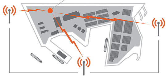
ITT Exelis is offering the Signal Sentry 1000, a proprietary product that detects, geolocates, and characterizes sources of intentional and unintentional interference to the U.S. GPS signals, and provides actionable intelligence to the user.
The system leverages GNSS signal domain knowledge, and is based upon patented technology developed through the company’s history of designing and fielding electronic intelligence systems, ITT Exelis said.
Leveraging Exelis GNSS signal domain knowledge, the system is implemented using commercially available GPS receiver and computer server/data technology. Actionable intelligence is available in the form of pin mapping of interference sources in addition to longitude/latitude/altitude data, all available through a web-enabled graphical user interface.
Signal Sentry 1000 can assist efforts to ensure GPS spectrum integrity and aid in law enforcement operations that require GPS availability. Benefits for users include:
Instantaneous identification and geolocation of jamming sources, improving situational awareness.
The long awaited results from the independent field trial of indoor wireless location technologies are here. TheFCC-chartered Communications Security, Reliability and Interoperability Council (CSRIC) tested NextNav, Qualcomm and Polaris. NextNav bested the others.
Speakers from NextNav and Polaris, as well as test adminstrator Technocom, will take part in a GPS World webinar on April 18. Registration is free.
Also, there is a guessing game in town and stakes are high. Who will President Obama nominate to replace FCC Chief Julius Genachowski? Tom Wheeler, popular in the telecom community, has been a front runner, but the tide may be turning against him with some charging that he is too snug with our industry.
Developers will be even more enticed to utilize indoor location now that Apple has signaled its market intents with the purchase of indoor-GPS company WifiSLAM. Safety and security mandates around the world are spurring a wave of telematics offerings by automotive OEMs. For more, read on.
Who Will Be the New FCC Chief? A coalition of public interest groups sent a letter to Obama warning that Wheeler is too close to the industry that he would be regulating. “You can’t have an objective chairman of the FCC that’s got 20 years of his life invested in being the head lobbyist for industry,” Sascha Meinrath of the New America Foundation said in an interview. In his past life, Wheeler was an industry lobbyist and also served as head of both CTIA and the National Cable and Telecommunications Association.
Adding to Wheeler’s woes, 37 Democratic senators have signed a letter supporting FCC Commissioner Jessica Rosenworcel. Since she already sits on the commission, Rosenworcel would not need Senate confirmation to ascend to the chairmanship. That could be appealing to Obama, who has faced GOP opposition to many of his second-term nominees.
However, it could also put Obama in a sticky spot, as he would have to jump over the FCC senior Democrat, Commissioner Mignon Clyburn, the daughter of Rep. James Clyburn, a member of the House Democratic leadership who has strong African-American support. Obama has been criticized for low minority leadership appointments in his second term.
Genachowski’s term was a disappointment to people on many sides of the fence, but not the all-out disaster of his predecessor, Kevin Martin. Genachowski will be remember for the introduction of the National Broadband Plan, as well as plans for a complete overhaul of the Universal Service Fund. During his time as chairman, Genachowski took the lead on killing AT&T’s proposed $39 billion acquisition of T-Mobile. The next FCC chair will need to navigate hefty issues including media ownership, Internet rules, universal and affordable broadband, and locking of phones.
How Good Is It Indoors? The FCC chartered CSRIC to test the indoor performance of location systems across urban, suburban and rural areas in the San Francisco Bay Area. TechnoCom, an independent agent, conducted the trial with more than 13,000 test calls placed from different technologies in 75 unique indoor locations. Three vendors submitted technologies for evaluation: Qualcomm, NextNav and Polaris. They were scored for horizontal and vertical accuracy, speed of location, and reliability and consistency of results. NextNav stood out for its performance on height and horizontal accuracy. The full report is available from the FCC.
To hear from the experts involved, tune in to GPS World’s webinar, “Indoor Positioning & Navigation: Results of the FCC’s CSRIC Bay Area Trials,” on Thursday, April 18. Speakers include Khaled Dessouky (Technocom); Ganesh Pattabiraman (NextNav); Norm Shaw (Polaris Wireless); and Greg Turetzky (CSR). Registration is free.
Apple Goes Inside. Apple has acquired indoor-GPS company WifiSLAM, a sign that the indoor mobile location market will be heating up. Apple’s involvement is a significant move that will ignite the developer community to rush to create more innovative apps and solutions based on indoor location. WiFiSlam is a two-year-old start-up that detects a phone user’s indoor location by analyzing the strengths and IDs of Wi-Fi signals in its vicinity. WiFiSlam has been offering the technology to developers for indoor mapping and new types of retail and social networking apps. Retail has been the first adopter of indoor technology.
Interactive Voice Ads Leverage Location. Nuance Communications unveiled Voice Ads, a new mobile ad format that enables consumers to interact directly with ad campaigns by speaking (or perhaps, yelling) into their smartphones. Voice Ads expands on voice and natural language technologies and leverages capabilities like location to deliver ads that prompt the user to ask questions. In a YouTube video, Mike McSherry of Nuance demonstrates a virtual Magic 8-Ball campaign that answers users’ verbal queries to promote a fictional deodorant brand. “Mobile has a monetization challenge,” McSherry told AllThingsD. “By introducing voice you can transcend the small screen size.”
Telematics Boom. The telematics market is about to ride a wave of growth. Vehicle OEMS are rolling out safety telematics in advance of safety and security mandates throughout the world including Europe (eCall, 2015), Russia (ERA GLONASS, 2013) and Brazil (Contran, 2013). ABI predicts that the OEM and aftermarket safety/security telematics vendors will see the number of users rise from 72 million at year-end to more than 300 million in 2018.
GPS Ankle Monitors Not Working. In 2012 the state of California started conducting tests on the GPS ankle devices that monitor more than 4,000 high-risk sex offenders and gang members. Officials discovered that the batteries died early and reported locations were off by as much as three miles. Tampering alerts failed and offenders could cover the devices with foil or use GPS jammers to go undetected. Many of California’s ankle monitors were replaced with devices from a different vendor, but test results of the new system were not made public.
Steve Spriggs was cited for holding his smartphone in his hand using it for navigation while driving. California code 23123 reads, “A person shall not drive a motor vehicle while using a wireless telephone unless that telephone is specifically designed and configured to allow hands-free listening and talking, and is used in that manner while driving.” Spriggs fought the ticket, saying the law does not apply to looking at maps.
But a judge of the appellate court said holding a phone to look at a map is distracted driving — the same as sending a text message — and the law applies. “Our review of the statute’s plain language leads us to conclude that the primary evil sought to be avoided is the distraction the driver faces when using his or her hands to operate the phone. That distraction would be present whether the wireless telephone was being used as a telephone, a GPS navigator, a clock or a device for sending and receiving text messages and emails. This case requires us to determine whether using a wireless phone solely for its map application function while driving violates Vehicle Code section 23123. We hold that it does. “
The National Safety Council has noted that there is no research or evidence that indicates voice-activated technologies eliminate or even reduce the distraction to the drivers’ mind.
Skyhook Wireless, a provider of location positioning, announced a partnership to integrate Skyhook’s hybrid location platform into Comodo’s Anti-Theft app for Android devices.
Comodo’s Anti-Theft for Android is a new service that enables customers to remotely locate, lock and recover a lost or stolen Android smartphone or tablet. The app can remotely capture and upload photos of whoever is operating the missing device to aid authorities in their recovery efforts and also in identifying the thief. The product is designed to address the security, monitoring, and management needs of users with limited time and IT support.
“Comodo selected Skyhook’s leading hybrid location service because of its precision, speed, and power efficiency, all of which are critical to Comodo in our mission to locate, track, and recover lost or stolen devices,” said Melih Abdulhayoglu of Comodo.
Comodo Anti-Theft for Android is free and available at the Android Play Store. Skyhook provides an SDK for developers across most platforms.
FairSearch.org has filed a complaint with the European Commission laying out what it sees as Google’s anti-competitive strategy to dominate the mobile marketplace and cement its control over consumer Internet data for online advertising as usage shifts to mobile.
The complaint says Google uses deceptive conduct to lockout competition in mobile. Google’s Android is the dominant smartphone operating system, running in 70 percent of units shipped at the end of 2012, according to Strategy Analytics. Google also dominates mobile search advertising with 96 percent of the market, according to eMarketer.
“Google is using its Android mobile operating system as a Trojan Horse to deceive partners, monopolize the mobile marketplace, and control consumer data,” said Thomas Vinje, counsel to the FairSearch coalition. “We are asking the commission to move quickly and decisively to protect competition and innovation in this critical market. Failure to act will only embolden Google to repeat its desktop abuses of dominance as consumers increasingly turn to a mobile platform dominated by Google’s Android operating system.”
FairSearch is an international coalition of 17 specialized search and technology companies whose members include Expedia, Microsoft, Nokia, Oracle, and TripAdvisor.
Google achieved its dominance in the smartphone operating system market by giving Android to device-makers for “free.” Android phone makers who want to include must-have Google apps such as Maps, YouTube, or Play are required to pre-load an entire suite of Google mobile services and to give them prominent default placement on the phone, the complaint says. This disadvantages other providers, charges FairSearch, and puts Google’s Android in control of consumer data on a majority of smartphones shipped today.
The FairSearch complaint comes at a time when users are increasingly switching from desktop to mobile platforms. Mobile Internet usage is expected to overtake desktop usage as soon as 2014, according to MindCommerce.
The European Commission is already considering how to remedy concerns that Google may be abusing its dominance in desktop search advertising, in particular Google’s search bias that favors its own services in search results.
Meanwhile, in April, six European data protection authorities began coordinating efforts to force Google to comply with European Union privacy laws they say Google violated by consolidating its privacy policies. Google paid a record fine to the U.S. Federal Trade Commission in August 2012 to settle charges it gave misleading privacy promises to Safari Internet browser users.
“European consumers deserve a rigorous investigation of Google’s mobile practices, and real protections against further abuses by Google,” said Vinje. “Given Google’s track record of ignoring the law, mobile Internet users should be very concerned.”
CrowdOptic, a maker of crowd-powered mobile applications for live events, and the Location Based Marketing Association (LBMA) have joined forces to develop and promote new focus-aware mobile technology for fans at live events.
Part of LBMA’s mandate is to foster research, innovation and pilot projects that push the boundaries of place-based marketing. Through this initiative, LBMA has partnered with several top-tier global brands carefully selected from among LBMA’s large network of marketing affiliates to introduce the new technology to consumers. The technology will be introduced in a series of test launches at major entertainment events throughout the summer, before making it widely to marketers in the fall, the association said.
Focus awareness combines traditional GPS-location awareness with data on where mobile users are aiming their smartphones. Focus-based technology enables new kinds of apps in which users aim their phones to engage with one another as they watch events simultaneously — for example to connect, chat or vote on the shared subject of focus. Focus-awareness also allows marketers to chart the shifting momentum in crowds.
The partnership comes as demand grows among LBMA’s network for mechanisms to enhance context-awareness in mobile. Marketers want to know how many phones are engaged with their apps as events are happening (heat), who those users are, where they are looking, and how the crowd’s engagement is dynamically changing moment to moment — all capabilities of CrowdOptic’s technology.
“Our vision of the future is new apps that dynamically adapt based on knowing what activities people in a crowd are watching and engaging in, as well as joining people with shared interests together, right there in the moment,” said Asif Khan, founder and president of LBMA.
“Focus is an emerging mobile category that will play a significant role in the next generation of location services,” said Brent Iadarola, Global Research Director of Mobile & Wireless Communications at Frost & Sullivan. “In contrast to augmented reality, which combines location and mobile Internet search to provide information on landmarks in static environments, focus-based services enable the tracking and tagging of objects (or individuals) in moving or dynamic environments. By enabling mobile users to point their phones at moving objects or people to access real-time information about their subject of interest, this area of technology in which CrowdOptic is a pioneer clearly presents some very unique and lucrative avenues for hyper-targeted marketing promotions, advertising, and mobile coupons.”
CrowdOptic is in use around the world in apps that enable users to “aim their phone” to act or interact — whether to discuss, report or discover other people based on their shared focus. The company powers a range of applications which vary from finding friends in a crowd, to aiming a phone to vote, to aiming to alternate views of a live broadcast, to aiming to connect with athletes and celebrities at live events. The technology works both through an app and anytime without an app, by historically mining the standard metadata tags embedded in shared photo images. The mechanisms used to acquire context beyond location include continuous streams of GPS, compass and triangulation algorithms illuminating common points of focus between mobile users.
The LBMA will begin to introduce these projects which leverage the CrowdOptic platform for top global brands beginning in the summer of 2013.
About LBMA – http://thelbma.com/
The Location Based Marketing Association is an international group dedicated to fostering research, education and collaborative innovation at the intersection of people, places, and media. Our goal is simple: To educate, share best practices, establish guidelines for growth and to promote the services of member companies to brands and other content-related providers. The over 600 members of the LBMA include retailers, restaurant chains, agencies, advertisers, media buyers, software and services providers, and wireless companies.
Editor’s Note: The following is summary of CoreLogic’s nationwide parcel database that was provided by CoreLogic, followed by a short Q & A from Eric Gakstatter and the end of the article.
When the Trust for Public Land (TPL)began organizing its extensive conservation research and project information, its executives planned several database initiatives to showcase the volume of land that has been conserved for public use to date. Already innovators in funding conservation projects and city park creation, the TPL team set a goal of using GIS technology to make it easy for government agencies and other partner organizations to find the information they need to generate public funding for land conservation. The challenge: Organizing decades’ worth of comprehensive research and historical project information to accurately depict the true volume of U.S. land conservation.
The initial project, TPL’s Protected Places Inventory (PPI), involved modernizing a database that included over 4,500 land projects spanning more than 40 years of conservation work. TPL knew the database needed nationwide parcel data to produce reports that would give urban residents, city officials and elected representatives more detailed information—such as the percentage of residents in the nation’s 40 largest cities who live within a half-mile of a park.
The National Conservation Easement Database (NCED) resulted from collaboration with four other leading conservation organizations to provide a comprehensive view of an estimated 40 million acres of privately owned conservation easement lands throughout the country. When TPL and its partners—Ducks Unlimited, Defenders of Wildlife, NatureServe and the Conservation Biology Institute—began work on what would become the NCED, the team discovered that many land trusts and entities that manage easements did not have those easements mapped at the parcel level. By mapping conservation easements at the parcel level, the easement database offers government agencies, land trusts and conservation professionals a more accurate assessment of an easement’s size and location.
Another project, the Conservation Almanac, which was developed around the same time as the Protected Places Inventory, presented a similar opportunity to enhance historical records with parcel-level data. Designed totrack land area conservation activity across the U.S., the Conservation Almanac helps key stakeholders understand the context of land conservation and funding from both the public and private sectors. This database helps answer common questions, such as how much land has been protected per state, which state and federal agencies have protected land, and what the cost to protect that land was.
“When looking to add to our databases, we soon discovered that in some areas, parcel data either didn’t exist or was so expensive through the local government that it prohibited our organization from economically acquiring it,” said Breece Robertson, TPL’s national conservation vision and GIS director. “Additionally, the data we did finally acquire was often outdated or incomplete.”
With that in mind, TPL began a search to find a cost-effective single source for nationwide parcel data. The organization found a solution through CoreLogic ParcelPoint, the largest standardized nationwide property database, which contains data for 134 million parcels, covering 2,391 counties and representing 93.6 percent of the U.S. population.
Parcel database architecture Source: CoreLogic
US ParcelPoint Coverage Source: CoreLogic
“With the help of CoreLogic, the organization’s budget for adding parcel data was significantly reduced, and the PPI project took a single year to complete instead of the estimated five years ,” said Robertson. “Plus, with more than 4,500 completed projects in the Protected Places Inventory database, it’s not only easier to keep the parcel boundary information current, but entering new projects now only takes 15 minutes instead of the previous three hours.”
Q & A on ParcelPoint
Gakstatter: What was the range of costs you were quoted from local governments for parcel data?
CoreLogic: It ranges from $60 for them to get the data onto a disk to mail to us, to upwards of $3-4k. One county in California quoted us $10k for their parcel data, another used to charge $1 million for their parcel data but they’ve since been forced to offer it for a nominal “packaging” fee.
Gakstatter: Are you going to/Did you enhance the parcel data you acquired? With what data and how?
CoreLogic: In some cases, we ran parcel prioritization analyses on the parcel data using many other datasets to show where priorities stack up on the landscape, such as size of parcel, adjacency to protected lands, adjacency to wildlife habitat areas, parcels that flood during storm events, etc. The parcels get tagged with a score or metric depending on how important it is for conservation based on a variety of inputs.
Gakstatter: Which horizontal datum do you use for your nationwide database? What is the estimated horizontal accuracy of the database?
CoreLogic: For all of our projects, we work locally so we always have to clip out the parcel data we need for an area and re-project that using either the local UTM or state plane projections.
Added 4/12/13 from CoreLogic: Spatial accuracy can be highly variable depending on the source of the data and the methods under which the data are created. CoreLogic employs statistically valid testing methodologies based on guidelines developed by the Federal Geographic Data Committee (FGDC) to provide quantitative and statistically valid accuracy statistics for the vast majority of counties within ParcelPoint. During the most recent compilation, the overall ParcelPoint dataset tested approximately five meters (15 feet) horizontal accuracy with a 95 percent confidence interval.
Gakstatter: Can you expand on the three programs and the process you went through to compile data before going “modern” with ParcelPoint?
CoreLogic: For all three programs, it was the same. We’d have to do a Google search to see if parcel data was readily available online. If not, we got a contact phone number for the local assessor’s office and contacted them. At that point, we found out what type of license agreement we would need to sign, or if there was a fee for the data. At that point, we would have to figure out if the license agreement was too stringent or if the cost of purchasing the data was prohibitive. We involved our legal staff to review the license agreements and provide suggested changes or write up addendum stating our use of the data for the county or city to consider. That process was expensive (in staff time) and took a long time with all of the back and forth. Finally, when we received the parcel data, if we were working on a project that spanned many counties or cities, we’d have to using GIS tools to project the data and stitch it together – running into issues like datasets not matching up or overlapping parcels, etc. With ParcelPoint, we just go to the database, clip out what we need and we are off and running. What used to take weeks or months to just acquire the parcel data from various entities now takes 15 minutes.
Follow Eric Gakstatter on Twitter by clicking here.
I probably reminisce a bit too much at times, but I can’t help but think back to the ’90s, when obtaining three-meter accuracy via post-processing took a bit of planning. You either had to operate your own GPS base station, or you had to find a publicly available one before you went to the field to make sure you had a source of base station data. Remember, back then publicly available CORS weren’t very common.
Then, towards the late ’90s, there were enough publicly available GPS CORS in the U.S. that you could collect data in the field without knowing where the closest base station was located, but you knew GPS base stations were so prolific that you could find one close enough to use for post-processing without prior planning/coordinating.
Then, sources of real-time GPS corrections started through the same progression. In the ’90s, if you wanted real-time corrections, you either had to operate your own GPS base station and wireless datalink or, if you were lucky you were close to a U.S. Coast Guard beacon transmitter, which were few a far between. OmniSTAR was an option, but subscription was a quite a bit more expensive back then and the equipment was bulky.
Today, post-processing is a no brainer. You don’t even need to have to license post-processing software. Through the National Geodetic Survey’s OPUS, Austraila’s AUSPOS and Canada’s CSRS-PPP, you can collect GPS data anywhere in the world, submit it to one of these free, online processing centers, and have the answer in your email inbox in a few minutes. But, as I’ve lamented more than once over the years, post-processing is a dinosaur. Mind you, it will never go away completely, but it doesn’t belong in the typical mainstream data collection workflow. It just doesn’t make sense.
As it was 20 years ago and as it is today, the challenge with real-time GPS/GNSS data collection is the wireless datalink. If you’ve ever worked with real-time GPS/GNSS data collection and had a unreliable wireless data link between the base and your receiver, you know what I mean. It’s exceedingly frustrating and unproductive. However, when everything is working as designed, the real-time GPS/GNSS data collection workflow is a thing of beauty.
Sources of high-precision real-time GPS/GNSS corrections are still a rather disparate group of public and commercial services that depend heavily on geography and communications infrastructure. For example, in the U.S. there is plenty of wireless coverage (GSM, CDMA, Wi-Fi) in metro areas and along major interstate roads, but there are still vast areas of rural farmland, prairie and desert where wireless networks don’t reach, leaving the choice of either satellite-based communications or setting up your own private wireless communications (UHF/VHF/900 MHz) between a base station and your receiver.
That said, there are more choices for real-time, high-precision GPS/GNSS corrections than ever before. In fact, just last week, the International GNSS Service (IGS) announced that it has started to offer a global real-time PPP data stream for high-precision, dual-frequency GPS receivers via NTRIP. That means anyone with a dual-frequency GPS receiver and an Internet connection can achieve sub-decimeter accuracy anywhere in the world, free of charge. How exciting is that! I think about the regions of the world like South America, Central and Southern Africa, Australia, and parts of Asia that aren’t served well by public SBAS or other free sources of high-precision GPS/GNSS corrections. This service will open up those regions to a new level of real-time, high-precision positioning. There’s one catch though; GPS/GNSS receiver designers have to implement special firmware to use the IGS RT PPP service. Some manufacturers are talking about implementing this, which would be a boon for the high-precision GNSS user community. Global IGS RT accuracy = ~10 cm.
Of course, OmniSTAR, Fugro, Starfire, Veripos have been providing real-time PPP for years (as well as Terrastar and Trimble more recently) in their respective vertical markets (land and offshore) but it requires an annual subscription fee and specialty hardware (L-band) to receive the signal. The receiver hardware can be prohibitively expensive for some potential users, and their coverage, based on leased communications satellite footprint, isn’t dependent on local Internet connectivity. However, I will say that OmniSTAR subscription pricing is very competitive now, and that a public service like what IGS is offering has no guarantees of availability or accuracy. On the other hand, since commercial services like OmniSTAR are collecting a fee, they have an obligation to service their users. Nevertheless, public, sub-meter SBAS services like WAAS, EGNOS, MSAS, GAGAN, and SDCM are offered to non-aviation users on the same terms as IGS, and those services have worked out very well for our surveying and mapping user community.
Other public sources of high-precision GPS/GNSS corrections are on the rise:
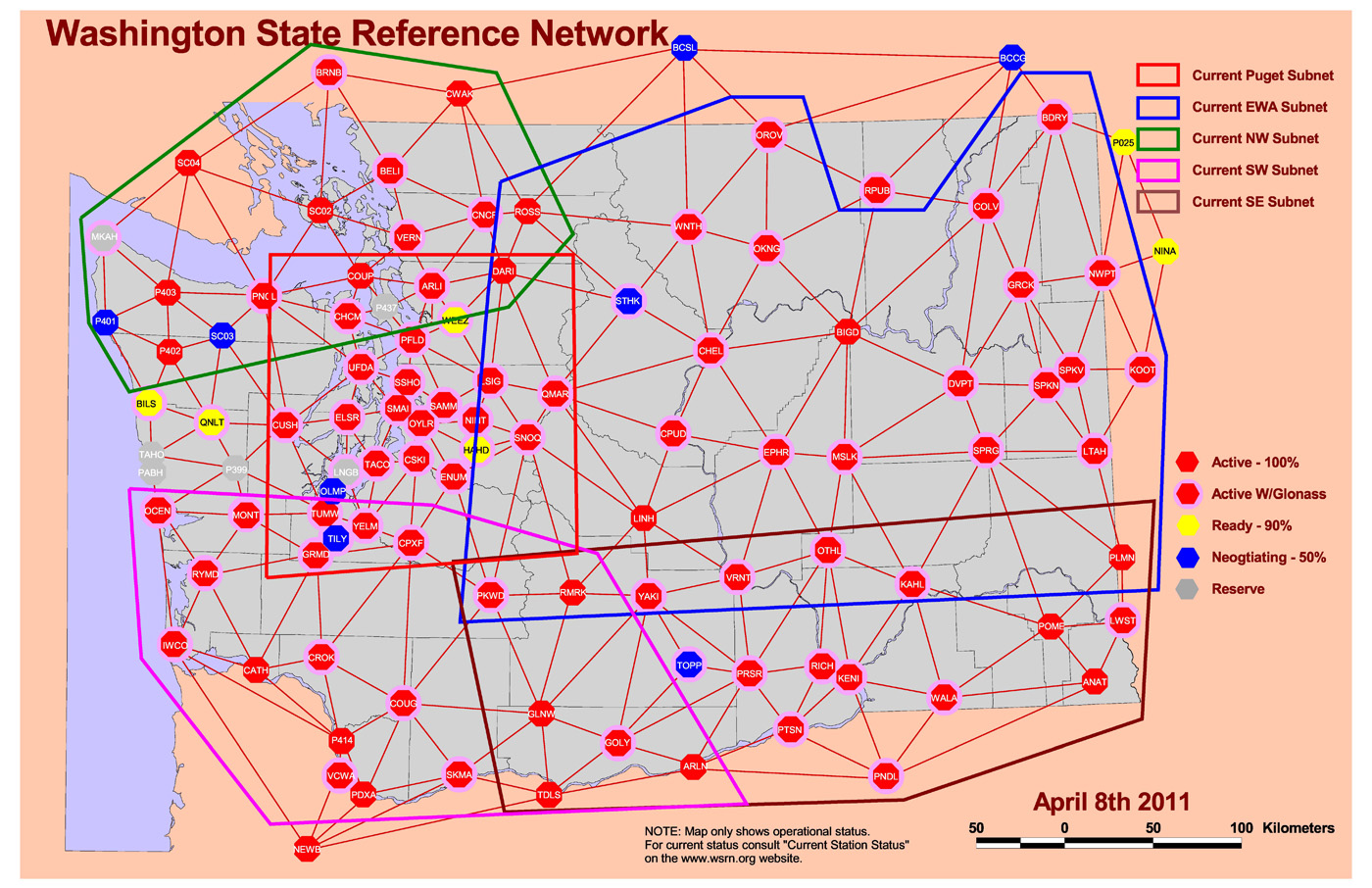
RTK Networks. RTK networks continue to proliferate. In the U.S., many states offer free access to their centimeter-level statewide RTK networks. These are somewhat well-known within the surveying and agriculture community, but not as well known within the GIS community. Many countries also offer regional and country-wide RTK networks. RTK network accuracy = 1-2 cm.
Washington State RTK Network Source: Washington State Reference Network. http://www.wsrn3.org/
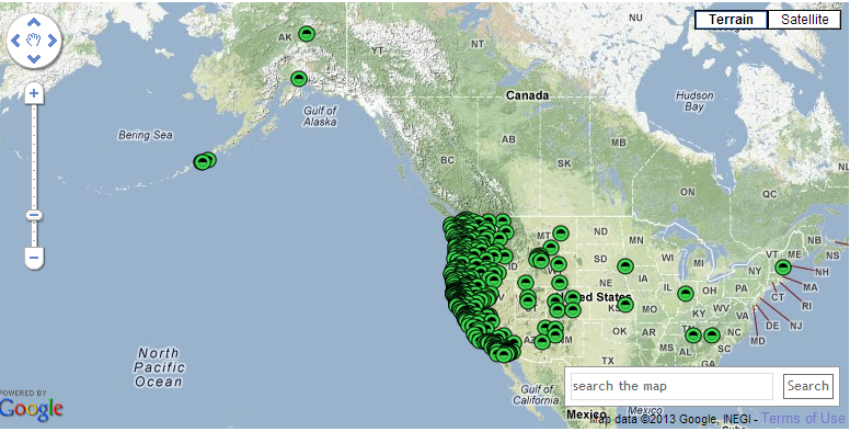
PBO real-time streaming. In the western U.S., UNAVCO’s Plate Boundary Observatory (PBO) maintains more than 1,000 GNSS base stations with many of them broadcasting RTCM3-formatted data. If you’re in California, Oregon, Washington, and the surrounding states, you should take a look at its website. The only requirement is that you have a receiver capable of handling RTCM3 data and you have Internet access in the field. You’ll also need an NTRIP client software (there are free ones available) running on your data collector (smartphone, handheld, tablet). Note that these are single baseline solutions (as opposed to the RTK network solution), so the further you are from the base station, the more error will be introduced. One caveat: be sure you understand which horizontal datum and epoch the particular PBO base station is streaming. PBO real-time streaming accuracy within 20 km = 1-2 cm.
PBO Station Streaming Map Source: UNAVCO Plate Boundary Observatory. http://pbo.unavco.org/data/gps/realtime
CORS Streaming. The National Geodetic Survey (NGS) is testing real-time streaming from nearly a couple of dozen CORS sites, mostly in the Eastern U.S. This is very similar to PBO real-time streaming. If you are 50-75 km from the base station, you’ll still be under 10 cm. If you’re within 20 km, you’ll be down to 1-2 cm.
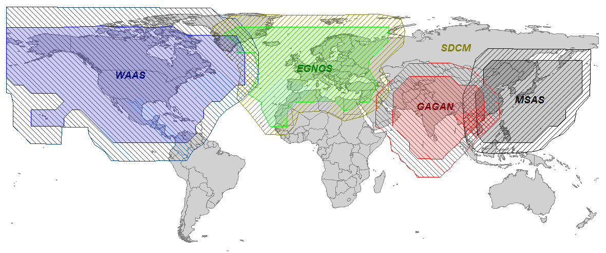
SBAS. SBAS (WAAS/EGNOS/MSAS/GAGAN/SDCM) was the first true source of public, country-wide high-precision GPS corrections. What make SBAS so easy is its ergonomics. It’s become such a standard that virtually every high-performance GPS/GNSS receiver designed today has SBAS capability built-in. You don’t need to purchase any extra hardware or software to use it. SBAS accuracy = sub-meter (with a receiver designed to optimize WAAS).
Global SBAS Coverage Map Source: Geneq, Inc. www.sxbluegps.com
There’s no doubt that years from now, we’ll look back and be amused at how “difficult” and expensive real-time, high-precision positioning was. Today, there are many more sources of high-precision, real-time GPS/GNSS corrections than there were ten years ago. In ten years, there may or may not be many more choices for high-precision GPS/GNSS corrections, but certainly the sources will be less complex, more ubiquitous and more convenient than they are today.
For the latest GPS/GNSS news, follow me on Twitter by clicking here.
Several weeks ago I attended the Esri Federal Users’ Conference in D.C. Not surprisingly, the conference was opened by Jack Dangermond, founder and president of Esri. As with most Esri conferences, there is too much to cover in this short column, so I’m providing my highlights.
Jack opened the conference by presenting the Esri “Making a Difference” award. This year it was given to the Army’s Arlington National Cemetery (ANC) and “make a difference” they did! Shown here accepting the award from Jack is Kathryn Condon, the Executive Director and Major Nicholas Miller, the Chief Information Officer (left).
Several years ago you may remember the scandalous news reports of very poor management and almost total lack of accountability at the ANC. Countless burial plots were misrecorded, finding a burial location for visiting family members was tedious, and some tombstones were even found dumped in a nearby stream. Tracking and management was accomplished via hand-typed index cards and colored pencil annotation of paper maps. We GISPs knew instantly that GIS was the answer and fortunately so did the Army. Their solution was thorough and elegant.
The Army, working with GIS, Inc., spent several months collecting more than 250,000 point locations of grave markers across the 624-acre cemetery. They used Trimble handheld GPS units to record each tombstone to an accuracy of three inches. Additionally, a digital photo of each tombstone was taken and recorded in the database. The result is an online system called ANC Explorer, which displays GIS maps, aerial imagery and digital photos of ANC that visitors can use to navigate the cemetery. Additionally, family members who can’t visit the cemetery in person can do a virtual search and tour.
Jack’s Vision
Jack outlined his long-standing vision of where GIS is and where it is heading. Much of his vision in the past was just that, a “vision.” However, reality has caught up. He spoke of the turning point brought about by cloud computing. He used the term “GIS as a platform” where software such as ArcGIS Online is mashed with other systems to create a pervasive geographic system that enables countless applications. Web maps point back to authoritative data sources rather than carrying the baggage of large local databases. Lightweight, agile applications are extendable, interoperable and permit easy collaboration. As part of this, the emphasis is on web maps as the new medium. He stated that web maps are simple, powerful, and cost effective for collaboration and integration. ArcGIS is the platform enabling this with three components: applications, content, and infrastructure.
To make all this happen, Esri is spending considerable time and effort not only on the technology, but to assemble extensive authoritative content. This is the big difference between Esri and Google. Google has changed how we all view computer mapping, but as many of us have learned over the years, Google is not necessarily an authoritative source. By its own admission, Google’s purpose is to attract users and drive them to advertising. They have no desire to become the world’s GIS expert. Esri on the other hand is working toward that goal. One example supporting this effort is Esri’s Landscape Analyst, which is being released this month. Similar to Community Analyst, designers can develop maps based on a variety of authoritative public data sets related to land use, land cover, pipelines, transmission lines, imagery, and many other features. The interesting aspect of Landscape Analyst is that more than 30 selected data sets can be used, downloaded, and incorporated into local applications.
Another announcement that caused a buzz was the free availability of DigitalGlobe World Imagery. The new update includes 30-cm imagery for the continental United States down to 1:1,000 scale, and 60-cm imagery for large parts of Western Europe down to 1:2,000 scale. Throughout the year, Esri and DigitalGlobe will grow the coverage with more than 100 million square kilometers of updated high-quality imagery, making it one of the most detailed free basemap services available.
CityEngine
For those of you interested in 3D GIS, CAD, BIM models, Voxels and visualization, CityEngine seems to blur the lines between each and merits a serious look. CityEngine was demonstrated during the plenary session, and is clearly a very fast and easy-to-use 3D modeling environment. It combines rapid 3D model creation from 2d GIS data, similar to Google SketchUp with serious database connectivity in a procedural-based environment.
Although I personally haven’t worked with CityEngine, the demos are impressive. See a video demo. CityEngine integrates standard file formats, including Collada, RenderMan, Google Earth, SketchUp, Wavefront, 3DS, Autodesk FBX, and WebGL. The CityEngine models can be viewed in ArcScene and WebScene. An interesting capability that could be very valuable for public meetings is a slider bar that can show inside/outside or before/after images.
One word of caution that I learned working with first responders is the use of textures or cloned images to create 3D models. Previous work I did with Pictometry and PLW Modelworks highlighted the difference between a representation of a 3D scene and use of actual geo-registered imagery. PLW builds 3D models that are “photorealistic” and “photo-accurate.” The models are built from imagery and each building is draped on each side with the actual measurable image of the building. As you can imagine, it’s important that a window shown 5 feet above ground is actually there and not just a graphic. If occlusions block some portion of the image, PLW makes no attempt to fake the image. It instead shows a no-data area that looks like a black shadow.
Note this example. The “shadow” is really a no-data location of the image.
Social Media
A pervasive topic that was part of numerous sessions and Expo exhibitors was social media and big data. The integration of this real-time data with GIS data and analytics is proving to enhance both, and its use is growing. There was a powerful example shown in the plenary session using Topsy technology. Topsy uses complex algorithms to do expert searches on thousands of tweets to discover information based on keywords or terms. The search ranks results based on topical focus and geography. Since only 1 percent of tweets are explicitly geotagged, Topsy developed machine learning methods to infer an author’s location, using features such as regular references to landmarks or events. By doing so, it claims to have high-confidence geographic information for more than 90 percent of tweets. The company demonstrated the benefit of plotting real-time tweets about power outages as a second, validating source of data during Hurricane Sandy.
Several exhibitors showed social media exploitation tools that were equally impressive. TerraGo demonstrated GeoXRAY, a system that combines GIS data with social media discovery and exploitation tools, brought together into a GeoPDF that can be used off-line in local collaborations by non-GIS users.
Other exhibitors were using social media for intelligence applications, financial analysis, and business and marketing applications, with a dizzying array of claims. My personal observation is that the social media environment is like the “Wild west.” Similar to the early days of GIS, there are competing products, repackaged data, and capabilities with overlapping systems. It will take a while to sort it out, but this is too important a topic to take lightly. Look for more information in future columns as I get educated.
The California Technology Agency has launched the California GeoPortal, an interactive and user-friendly gateway to thousands of geographic data sources around the country.
“California’s new GeoPortal organizes important geographic data and makes it more accessible and useful,” said Secretary Carlos Ramos. “This innovation increases government transparency, boosts efficiency and saves the State money.”
According to the announcement, the California GeoPortal helps find solutions to real-world problems such as locating a new business or helping choose a new place to live. The GeoPortal gathers thousands of data sources such as demographics, environmental hazards, school information and transportation, and makes the information more accessible and useful. The GeoPortal strengthens these databases by combining information and making it customizable.
“For the first time in our history, California is taking a statewide approach to sharing data and mapping it to provide a visual location based view for our stakeholders – both public and private industry,” said Scott Gregory, California’s Geographic Information Officer. “By making these diverse resources accessible and relevant, it becomes a very efficient and powerful decision making tool for all Californians.”
“The GeoPortal is a groundbreaking tool enhancing collaboration and data sharing among the public and private sector,” said Carl Guardino, the Chief Executive Officer of the Silicon Valley Leadership Group. “Business will have accurate and relevant data at their fingertips, supporting their decisions to help grow California’s economy.”
The announcement stated that California’s GeoPortal is a comprehensive catalog of thousands of data sources from federal, state, county, city, tribal and education geographic resources. Users can access the GeoPortal from the web without having to login to another system, streamlining access to government derived and developed data.
“The ability to share geospatial data through a single public source will be a tremendous benefit to the academic institutions in California,” said Dr. Shawna Dark, Department of Geography Chair, California State University, Northridge.
The GeoPortal is a service offering by the California Technology Agency to state and local agencies and departments at no cost. It is a tool to be leveraged by organizations to catalog and manage their geographic data resources. Organizations will be able to register their geographic data content on the GeoPortal and securely manage their information. It has a robust set of management tools that allow organizations to edit, upload and maintain geographic information. The end result is a more comprehensive and authoritative data resource for geographic data in California.
For a video introduction to the California GeoPortal, visit here.
The USGS announced it is expanding the involvement of volunteers to enhance data collection about structures for The National Map.
This program, known as The National Map Corps, focuses on encouraging citizens to collect data relating to structures by both adding new features and/or correcting existing data within The National Map database. These structures can include schools, hospitals, post offices, police stations and other important public places.
According to the announcement, collaborative pilot projects in Colorado were recently used to test the concept of crowd-sourcing. While the project is on-going, early indications point to positive results and show the success of using TNMC volunteers to enhance data sets.
The USGS reported that over a trial period of ten months, 143 volunteers collected, improved, or deleted data on more than 6,400 structures in Colorado. The volunteers’ actions were accurate and exceeded USGS quality standards. In the Colorado pilot project the volunteer-collected data showed an improvement of approximately 25 percent in both location and attribute accuracy for existing data points. Completeness, or the extent to which all appropriate features were identified and recorded, was nearly perfect.
The significant results of the Colorado pilot have led to a phased, nation-wide expansion of the crowd-sourcing /volunteer project. The states in the first expansion of TNMC are: Arkansas, Alaska, Colorado, Delaware, Georgia, Idaho, Maryland, Michigan, Montana, North Dakota, New Jersey, New Mexico, Ohio, Oregon, South Carolina, Utah, Washington, West Virginia
After an evaluation of the quality and procedures of the first group of states, the second set will be made available. Ultimately, by the end of 2013, the third batch of states will complete the expansion of the program.
“The response by volunteers in Colorado exceeded our expectations both in terms of the number of volunteers and the quality of the data they collected”, said Kari Craun, the Director of the USGS National Geospatial Technical Operations Center. “The Volunteered Geographic Information (VGI) community represents a fantastic, untapped resource to assist USGS in maintaining data that are part of The National Map.”
While some familiarity with the area that a volunteer chooses is helpful, one doesn’t have to live near a particular place to contribute. The tools on TNMC website, along with ancillary information available on the Internet, are generally sufficient to edit a distant area.
There have been several instances of crowd-sourced geographic information making significant contributions to research and databases in government, private sector, and non-profit organizations. The goal of the TNMC is to provide data for the nation’s primary federal mapping agency in its effort to provide accurate and authoritative spatial data via the web-based National Map.
The citizen geographers/cartographers who participate in this program will make a significant addition to the USGS’s ability to provide accurate information to the public. Data collected by volunteers become part of TNM Structures dataset which is available to users free of charge.
Without a network of volunteers, the desired information would not be collected this year and the existing data would not be updated. TNMC volunteers perform important work that otherwise will not be accomplished in the foreseeable future.
Becoming a volunteer for TNMC is easy; go to the National Map Corps website to learn more and to sign up as a volunteer. If you have access to the Internet and are willing to dedicate some time to editing map data, we hope you will consider participating!