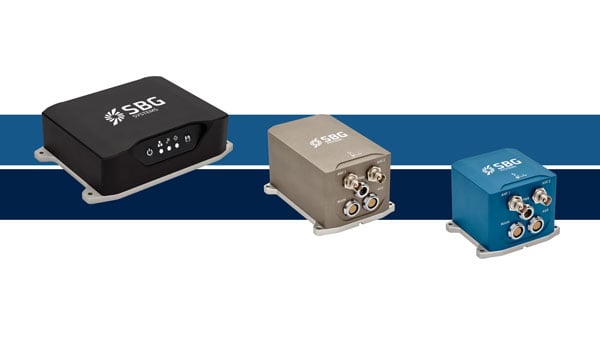
SBG Systems has upgraded its inertial navigation systems — Ekinox, Apogee and Navsight— with new GNSS receiver options designed to offer greater flexibility while maintaining high precision and reliability.
Previously, SBG Systems integrated a triple-band GNSS receiver with RTK and Fugro Marinestar capabilities into its navigation solutions. The latest update introduces three additional GNSS receiver variants, each tailored to specific regional and application needs. These include:
Marinestar: This variant supports Fugro Marinestar, delivering precise point positioning (PPP) with centimeter-level accuracy via L-band corrections without requiring a base station. It is optimized for marine applications such as hydrographic surveys and dredging.
HAS Ready / NavIC: Designed for future compatibility, this variant includes Galileo E6 support for the upcoming Galileo High Accuracy Service (HAS), offering free decimeter-level PPP corrections globally. Additionally, it supports the Indian NavIC system, making it suitable for applications in urban environments, aviation and operations in India.
Centimeter-Level Augmentation Service(CLAS): Tailored for users in Japan, this variant utilizes QZSS L6 signals to provide free PPP corrections without external services. It is ideal for land and marine navigation in Japan.
All GNSS variants integrate seamlessly with SBG Systems’ antenna portfolio and Qinertia post-processing software. Users select the appropriate GNSS variant at purchase to match their operational requirements. These enhancements aim to provide versatile solutions across diverse industries while ensuring reliable performance.
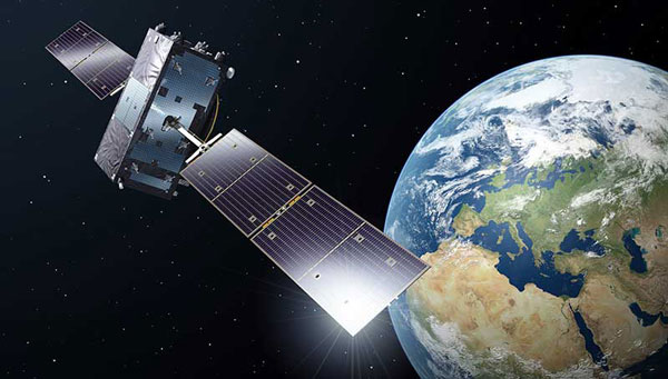
The European Union Agency for the Space Programme (EUSPA) has awarded GMV a framework contract to advance the Galileo Reference Centre (GRC), a key facility for monitoring and evaluating the performance of the Galileo satellite navigation system. Located in Noordwijk, the Netherlands, the GRC independently assesses Galileo’s operations, signal quality, and user-level service performance and compares its performance with that of other GNSS.
The upcoming GRC V2 version will introduce real-time monitoring capabilities, enhancing EUSPA’s ability to oversee GNSS services. This evolution will support additional Galileo services, including:
Signal Authentication Service (SAS): Strengthening trust in Galileo signals.
Time Dissemination Service: Enabling precise synchronization for critical infrastructure.
Search and Rescue (SAR): Improving emergency response operations.
Emergency Warning Satellite Service (EWSS): Facilitating public alerts for natural disasters and emergencies.
Key operational improvements in GRC V2 include:
Enhanced monitoring using data from multiple institutions.
Real-time processing for faster user notifications.
Seamless system upgrades without disrupting operations.
Advanced cybersecurity measures integrated into a platform-as-a-service model.
The upgraded GRC is expected to be operational by 2026 without impacting ongoing functions.
GPS World is a business-to-business magazine, and most of our readers are engineers, surveyors and other professionals specializing in geospatial technologies. In general, we do not cover consumer applications. Nevertheless, it is important to remember that, while GPS was designed and built, and is managed, by the U.S. military (from 1973 to 2020 by the U.S. Air Force, since then by the U.S. Space Force), more than 99.9% of its users are not members of the U.S. military, nor surveyors, but consumers. They benefit from GPS — and the three other GNSS, namely Russia’s GLONASS, China’s BeiDou and Europe’s Galileo — in many ways and are unaware of most of them, such as the fact that GNSS receivers provide essential timing for radio and television broadcasts, cellphone communications and financial transactions.
The vast majority of consumers access GNSS via their smartphones. We are all familiar with the myriad smartphone applications that rely on GNSS for positioning and navigation — from Google Maps and Apple Maps to Waze and social media platforms such as Instagram. Additionally, weather apps, such as the Apple Weather app, and parking apps utilize GNSS to enhance user experience and functionality. Nearly all smartphones today use at least three of the GNSS constellations — GPS, GLONASS and Galileo — and some use all four. (The use of BeiDou in the United States is a controversial topic that we will explore soon.)
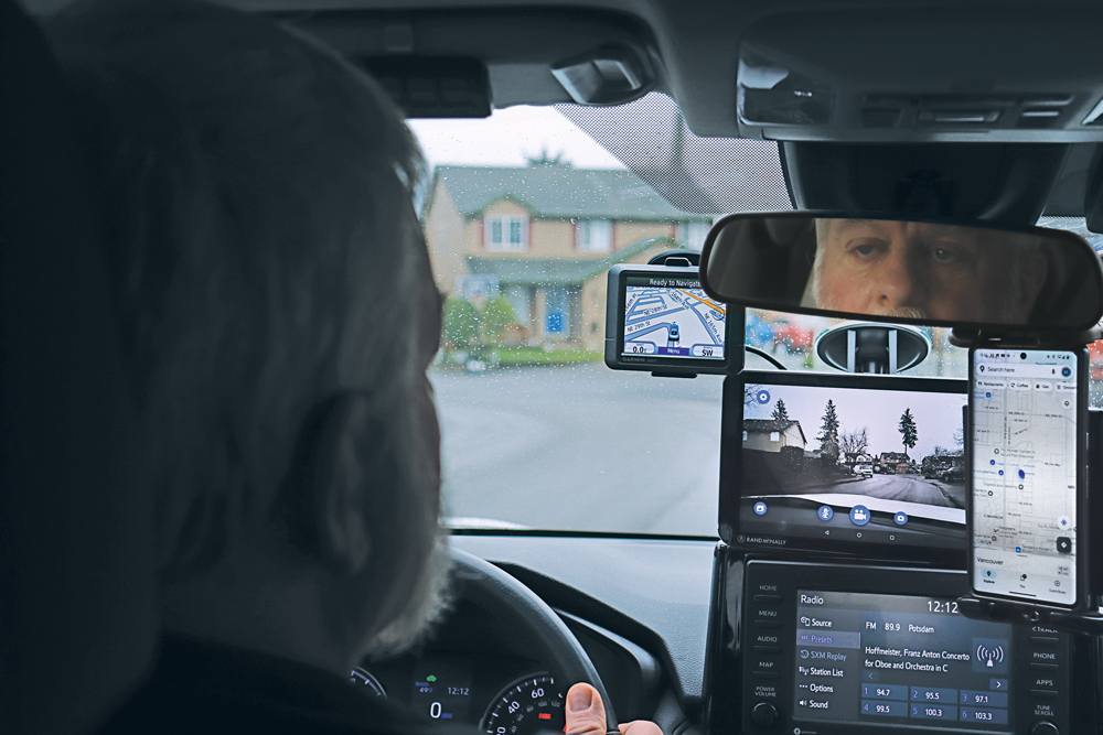
For most people, smartphones have replaced such previously separate electronic devices as calculators, digital cameras and car navigators. (A freestanding GNSS-based car navigation device is still useful, however, when you travel in areas with spotty or nonexistent cell phone coverage, because it relies on maps stored on the device, so it does not require an Internet connection. That is why I still carry a nearly 20-year-old Garmin nüvi in my car.)
For a few years, there were even handheld televisions. (My 1989 Casio TV-400 LCD Pocket Color handheld VHF-UHF TV has a 4 cm x 3 cm LCD screen. It is analog, however, so it stopped working when U.S. television broadcasts switched to digital in 2009.) Now, many people watch news, shows and movies on their phones.
Nevertheless, there are still many freestanding GNSS-based devices. For example:
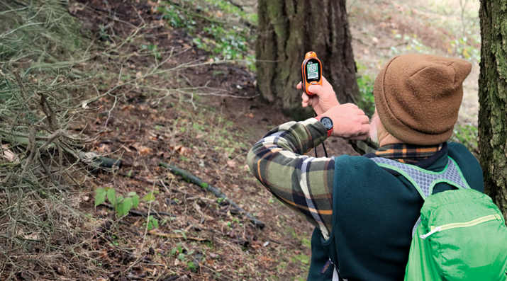
Handheld receivers for hikers and boaters that display your position and heading on topographic maps or nautical charts, as well as such information as elevation, speed, distance to your destination, number of GNSS satellites in view, tides, and sunset and sunrise times.
Cyclometers that show bicyclists their speed, pace and position on a map.
Fitness trackers and smartwatches that track your exercise, sleep, heart rate and biometric data.
Tracking devices that monitor the movements of people, such as children and Alzheimer’s patients, and help recover stolen vehicles and boats.
Additionally, many digital cameras have GNSS receivers that insert the location of each photo into their metadata.
Since I began working in this industry 25 years ago, I have always detested the term “GPS tracker” because it reinforces the already widely held misperception that a GPS receiver somehow “tracks” its user. As most readers of this magazine know, GPS receivers only display and/or store location data for the user, without sharing it with anyone else, let alone broadcasting it. Tracking something requires coupling a GPS receiver with a way to transmit the location data — typically, using a cellphone connection. Plus, nowadays, the word GPS should in most cases be replaced with GNSS. Therefore, I am always careful to say or write “GNSS-based devices.”
What follows highlights three very different GNSS applications in consumer devices:
Handheld receivers and smartwatches by Garmin for outdoor recreation and fitness.
GNSS-based tracking of vulnerable people.
A smartphone application from Google to monitor jamming and spoofing.
— Matteo Luccio, Editor-in-Chief
A nearly 20-year-old Garmin nüvi still provides the author navigation in areas without cellphone reception. (Photo: Matteo Luccio)
Handheld GNSS Receivers
Garmin, founded in 1989, is the 800-pound gorilla in the consumer GNSS market. The company’s annual revenue of more than $5 billion is comparable to the nearly $4 billion annual revenue of Trimble, founded in 1978, which is the 800-pound gorilla in industrial GNSS markets.
Garmin sells a vast array of handheld receivers, smartwatches and other devices for outdoor recreation and fitness, as well as GNSS receivers for general aviation and marine navigation.
In remote areas with scant or no cellphone reception, Garmin’s GNSS receivers offer users substantially more reliable satellite reception and greater positioning accuracy than smartphones. That is for two reasons. First, because a Garmin receiver can host a larger GNSS antenna than a smartphone, which contains several antennas. Second, because it is mostly dedicated to the positioning and navigation mission — unlike the many missions crammed into a smartphone.
Garmin’s multi-constellation and multi-band GNSS handheld receivers come with preloaded topographical maps optimized for outdoor activities, with terrain contours, summits, coastlines and more.
Garmin’s latest line of handheld GNSS navigators — the Montana 710i and Montana 760i — feature built-in inReach technology, which allows users to stay in touch when venturing beyond cell service using reliable satellite communication. Users can utilize two-way text messaging and location tracking via the global Iridium satellite network. In the event of an emergency, users can send an interactive SOS message to Garmin Response, an international emergency assistance coordination center that is staffed 24/7/365.
These devices are ideal for a variety of outdoor activities, including hiking, mountain biking, off-road riding and more. They are also compatible with multiple mounting options to adapt for use on ATVs, boats, cars, motorcycles, RVs and other vehicles.
Garmin Smartwatches
Garmin smartwatches have established themselves as leaders in the fitness and outdoor adventure market. Whether running, cycling, swimming or golfing, Garmin smartwatches provide users with many activity-specific features and metrics.
These watches feature advanced heart rate monitors and pulse oximeters for health monitoring. The company’s latest line of smartwatches come with a Body Battery feature that continuously analyzes combinations of the user’s heart rate, heart rate variability and movement data. The goal of this analysis is to identify meaningful physiological states and to describe the impact they have on the body’s energy levels. At a high level, this means documenting whether users are awake or asleep and when they are physically active, as well as tracking stress levels during periods of inactivity, according to Garmin.
Garmin smartwatches also feature additional sensors to improve location data. They include an altimeter sensor that helps track elevation changes and an accelerometer that detects movement. The latter is used for such tasks as step counting, sleep tracking and other activity measurements.
Garmin watches use multi-constellation (GPS, GLONASS, BeiDou and Galileo) GNSS receivers that enable accurate distance, pace and route mapping during outdoor activities, even in challenging environments.
— Jesse Khalil, Associate Editor
Tracking Family Members and Pets
The Satellai Collar features a lightweight tracker attached to a padded harness designed to avoid snags, discomfort or mobility restrictions. (Photo: Satellai)
GNSS technology enables consumers to track those most important to them – their family, friends and even their pets.
Companies such as u-blox offer devices that can be worn by the elderly and children to enable their caregivers or parents to track them. The devices help locate individuals through ›GNSS receivers (using all four GNSS constellations); Bluetooth, Wi-Fi and low power wide-area cellular communications; and cloud connectivity.
Families can monitor the movements of their children as they travel to and from school by bus by tracking those buses as they drive along their routes. Families can better time their kids’ departure to the bus stop in the morning and know when the bus has returned in the afternoon — all by viewing a live tracking function, provided by the school district, on their computer or smartphone.
Some of the newest tracking technology was on display at this year’s Consumer Electronics Show (CES) in Las Vegas in January. SATELLAI, a provider of AI-integrated pet solutions, showcased its SATELLAI Tracker and SATELLAI Collar. “The SATELLAI Tracker and the SATELLAI Collar use satellite and AI technologies to accurately relay their positions and status at all times,” said Mark Mao, founder and CEO of SATELLAI.
The lightweight tracker attaches to a padded harness that won’t snag, cause discomfort or hinder a pet’s mobility, according to the company. It features the Qualcomm MDM9205S modem, the 3GPP Rel17 5G IoT-NTN satellite communications system and the Aware platform, allowing it to use both cellular and satellite communication for continuous tracking even in remote areas without terrestrial cellular coverage. Working with the Skylo communications network ensures that the tracker works with more than 680 global networks across more than 180 countries. The SATELLAI Collar leverages a dual antenna and a multi-constellation GNSS receiver to deliver precise tracking, even in areas with low connectivity, the company adds.
Tractive, a global provider of pet GNSS and health tracking, also unveiled its latest dog tracker at CES in Las Vegas. Companies are also offering new ways to keep pets within areas chosen by their owners. According to Tractive, most virtual fences use a collar-mounted GNSS-based tracker in combination with an app or software. Users can create their preferred fence boundaries and receive notifications when pets cross them. Utilizing Mapbox’s advanced mapping platform, the SATELLAI Collar also allows users to manage these virtual boundaries, supporting overlapping and nested fences. The collar supports virtual fencing for areas up to 100,000 acres. Virtual fences are also commonly used with cattle.
— Brian Richesson, Senior Editor-in-Chief
Google Tools for Detecting Jamming & Spoofing
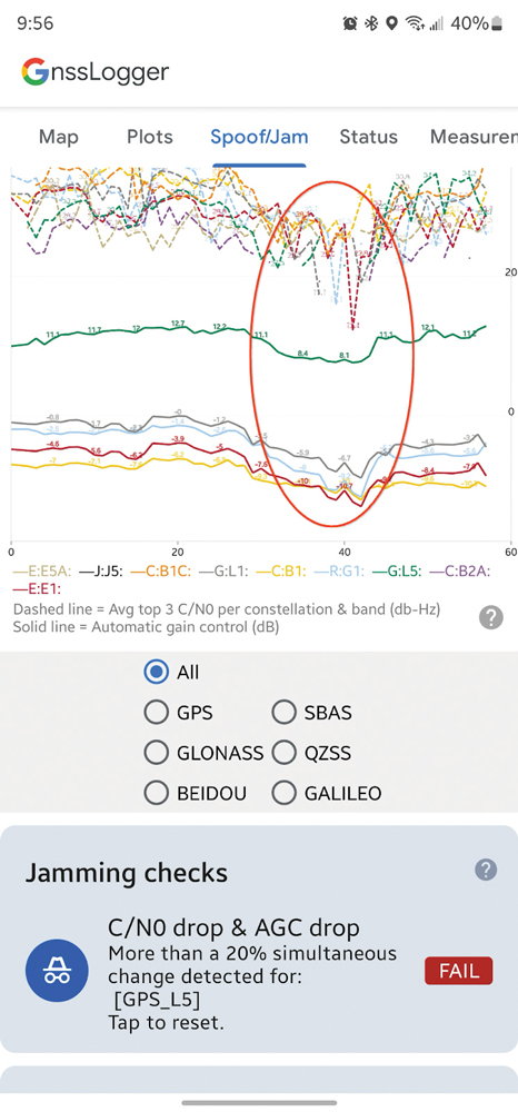
AGC and C/N0 both drop when a phone is held next to a Wi-Fi router (red oval). (Screenshot from Google)
The sharp increase in the past few years of instances of GNSS jamming and spoofing, much discussed in these pages especially with regards to civil aviation, also affects smartphones, smartwatches and other consumer devices. Google — which makes the Pixel phones as well as Android, the most used operating system, which is used by three quarters of the world’s smartphones — has been developing a tool to help detect these attacks.
It is based on the fact that the carrier-to-noise ratio (C/No) of the signal as well as the automatic gain control (AGC) of the GNSS radio in the phone can be good indicators of interference. “The AGC tends to dip when spoofing or jamming is observed,” said Mohammed Khider, Ph.D., manager and senior staff software engineer at Google. However, he pointed out, for jamming events the C/N0 value drops while for spoofing it increases.
Making use of this effect, desktop tools that log data and analyze the AGC and C/No have long made it possible to detect interference. Now, Android users can do the same thing on their phones in real time, using the spoof/jam tab in Google’s GnssLogger app. It creates a graphic of AGC and C/No for each GNSS constellation and band. Moreover, the app cross checks the GNSS signals with other independent sources of information to flag potential jamming and interference. Below the real-time plot of AGC and C/N0 are a series of additional automated jamming and spoofing checks.
This is an experimental feature, and the algorithms behind it will be further improved as research progresses, Khider pointed out. Moreover, it will not catch all jamming or spoofing. However, it will make it much easier to examine data related to these GNSS interference events in real time.
Google launched its GnssLogger app in 2020, and it has been a leading tool for the GNSS community to better understand positioning and navigation on smartphones. “It helped establish a de-facto CSV (.txt) standard for raw measurements and other data for Android devices that has been used in many other tools, including Google’s own Gnss Analysis app,” said Khider.
Last fall, in addition to the new spoof/jam screen discussed above, Google also launched GnssLogger for Wear OS, a new companion app for Android smartwatches that offers several of the key features found in the phone app, and a new measurements screen, which enables users to view GNSS raw measurements in real time.
Xona Space Systems and Trimble have collaborated to integrate Trimble correction services with Xona’s PULSAR high-performance navigation service.
Initial satellite launches are expected in late 2026 with service starting in 2027 through the PULSAR satellite network, enabling secure, high-precision positioning for applications ranging from geospatial to low-power mass mobile and IoT. In support of this new and developing collaboration, Xona has received an investment from Trimble Ventures.
Xona PULSAR, powered by Xona’s planned network of small satellites in low-Earth orbit (LEO), is being developed to deliver robust and secure high-precision positioning and navigation services directly to current GNSS hardware. The PULSAR service, which will include high precision correction services through this collaboration, has the potential to provide scalable, cost-effective solutions for industries with demanding positioning and navigation requirements, such as civil construction, surveying and mapping, and automotive and IoT applications. Xona’s signals are also expected to enable operations inside low-rise buildings, as well as improve resistance to jamming and interference compared to current GNSS capabilities.
Precision positioning solutions from LEO constellations are intended to provide new enhanced capabilities along with high levels of uptime to meet the rapidly evolving needs of industries around the world. Including Trimble correction services with Xona PULSAR is expected to enhance the reliability of Trimble correction services delivery, which is crucial for users in areas without reliable cell coverage, limited sky visibility environments, including high-latitude regions and other challenging geographies.
DJI has introduced the DJI Dock 3, its first “drone-in-a-box” solution designed for vehicle-mounted deployments and 24/7 remote operations in various environments. This system is compatible with the Matrice 4D and Matrice 4TD UAVs, which feature advanced cameras and IP-rated protection for challenging conditions. The UAVs are ideal for public safety, emergency response and infrastructure inspection.
When pre-heated, the DJI Dock 3 can operate in temperatures as high as 50 °C and as low as -30 °C. It is IP56-rated dust and water-resistant to protect its internal systems. The accompanying UAV features IP55-rated protection and low-noise anti-ice propellers to ensure stable flights in freezing rain or winds up to 12 m/s.
This system supports flexible deployment options, including vehicle-mounted setups optimized for emergency operations and long-distance inspections. It enables horizontal calibration and cloud-based dock location adjustments. For enhanced efficiency, two docks can be mounted on a single vehicle to facilitate dual-UAV rotations. In fixed deployments, the D-RTK 3 Relay Fixed Deployment Version can be added to improve video transmission and satellite connectivity.
The Matrice 4D and 4TD UAVs have a wide-angle camera, medium tele camera, tele camera and laser range finder. The Matrice 4D features an advanced camera suite designed for high-precision mapping. The Matrice 4TD includes an infrared thermal camera for public safety and emergency response applications.
The system also features an airborne relay function using the DJI RC Plus 2 Enterprise controller. This allows one drone to act as a relay to extend the operational range of another drone in areas without a 4G signal or with obstructions, making it particularly useful for search and rescue missions or inspections in mountainous regions.
The DJI Dock 3 integrates seamlessly with DJI FlightHub 2 to enable intelligent aerial operations. Automated flight routes allow drones to capture images or detect anomalies autonomously. Features like intelligent change detection provide periodic analyses of environmental changes, while the Virtual Cockpit interface allows operators to adjust gimbal orientation remotely using the new Mouselook feature.
To support regulatory compliance in strictly controlled airspace, the system includes a Flight Termination System , which can manually or automatically stop drone operations if necessary. Additionally, DJI Care Enterprise Plus offers comprehensive protection plans that include unlimited repairs within coverage limits and battery replacements.
The Android version of the Eos Tools Pro app by Eos Positioning Systems (Eos) now fully supports the new Skadi Series GNSS receivers. This update introduces advanced features of the Skadi Series, such as Skadi Tilt Compensation and the Skadi Smart Handle, to Android users.
Key features of the update include:
Flexibility across receiver models: Android users can now use Eos Tools Pro with Skadi Series receivers, as well as Arrow Series GNSS receivers, while maintaining a user-friendly design.
Tilt compensation for streamlined workflows: The app processes tilt-compensated GNSS positions provided by Skadi Tilt Compensation, allowing for accurate positional data even when survey poles are tilted. These values can be streamed directly to third-party apps without additional steps.
Enhanced accuracy with Skadi Smart Handle: The Skadi Smart Handle allows users to achieve RTK-level accuracy during GNSS positioning without a physical range pole, making it ideal for handheld setups.
Integration with third-party applications: All GNSS data, including tilt-compensated and Smart Handle-processed values, can be seamlessly transmitted to third-party mobile apps, simplifying workflows.
The updated Eos Tools Pro app is available for download on the Google Play Store.
Project Manager Positioning, Navigation and Timing’s Mounted PNT product office has received full-rate production approval for the Mounted Assured Positioning, Navigation and Timing System Generation II (MAPS Gen II), a key Army modernization initiative, from the Program Executive Office Intelligence, Electronic Warfare and Sensors. This approval allows the Mounted PNT office, in collaboration with Collins Aerospace, to begin full-rate production and fielding of MAPS Gen II as it moves toward initial operating capability.
MAPS Gen II provides GPS anti-spoofing and anti-jamming capabilities through sensor fusion algorithms and non-radio frequency sensors. These features enable mounted soldiers to operate in environments where military GPS is denied or degraded. The system supports U.S. Army forces by allowing them to move, shoot and communicate effectively while distributing PNT data to multiple users on a single platform. This is designed to eliminate redundant GPS receivers and antennas.
The system includes anti-jamming and anti-spoofing protection, a sensor fusion processor that integrates multiple PNT sources, and open architectures such as APSN and VICTORY. It outputs PNT data through multiple distribution standards, ensuring compatibility across platforms.
For the fourth consecutive year, Jammertest will take place in Bleik on Andøya, Norway, with applications now open until March 15, 2025. This event serves as a critical platform for industry and equipment manufacturers to test their systems against jamming and spoofing attacks, identify vulnerabilities and develop more resilient solutions. It attracts participants from diverse sectors, including the global automotive and security industries, telecommunications, academia and government authorities.
The event’s importance is underscored by the growing reliance of civilian services on satellite communications. Essential societal functions — such as transportation, emergency services, electronic communication, financial systems, and power supply — depend on accurate satellite-based positioning and timing. However, incidents of signal interference have highlighted vulnerabilities. For example, rescue helicopters in Norway have faced landing difficulties due to disrupted signals, and airports have been affected by illegal jammers. Airlines have also reported spoofing activity. According to the Norwegian Communications Authority, GNSS interference is an escalating concern that demands ongoing testing and innovation.
Jamming refers to the deliberate disruption of signals such as GPS or radio frequencies, while spoofing involves transmitting false signals to deceive receivers. Both tactics pose significant risks to civilian infrastructure. The Jammertest provides a unique opportunity for participants to evaluate their equipment under real-world conditions at Andøya’s remote location. This setting allows for “open air” testing without risking disruptions to civilian infrastructure or air traffic control systems — an advantage not feasible in densely populated areas.
Andøya’s geography makes it an ideal site for these trials. Surrounded by mountains and isolated from major population centers, it enables high-power signal testing while minimizing societal impact. Participants receive direct feedback on how their systems perform under controlled interference scenarios.
About Jammertest
Jammertest is recognized as the world’s largest open arena for testing resilience against jamming and spoofing attacks. It is organized in collaboration with several Norwegian authorities, including the Norwegian Public Roads Administration, Norwegian Communications Authority, Norwegian Defense Research Establishment, Norwegian Metrology Service, Norwegian Space Agency, Norwegian Mapping Authority, and Testnor.
This year’s event is scheduled from Sept. 15-19, 2025.
Astranis has completed a critical demonstration for the U.S. Space Force’s Resilient GPS (R-GPS) program, showcasing its ability to transmit core GPS waveforms using software-defined radio hardware. Conducted ahead of schedule and within budget, the demonstration highlights Astranis’ ability to adapt its flight-heritage high-orbit satellite hardware to meet new resilience requirements for the Space Force.
The test took place at Astranis’ headquarters in San Francisco, California, using a flight-like software-defined radio and positioning, navigation and timing algorithms provided by Xona Space Systems, a partner and subcontractor for the R-GPS program. Astranis transmitted a GPS Course Acquisition (C/A) navigation signal through its resilient GPS payload and demonstrated signal acquisition and recovery of Legacy Navigation messages with an off-the-shelf GPS receiver. According to Astranis, this validated that its resilient GPS design, Nexus, complies with GPS specifications “out of the box,” ensuring compatibility with existing user equipment without requiring costly upgrades.
Astranis was selected in September 2024 as one of four contractors to design next-generation resilient GPS satellites under the Space Force’s initiative. The company received its Authority to Proceed on Sept. 19, 2024, and has since exceeded program objectives ahead of schedule. The R-GPS program aims to augment the existing GPS constellation with smaller, cost-effective satellites to enhance resilience against threats such as jamming or spoofing.
Astranis is advancing its satellite design in preparation for the Space Force’s goal of launching the first eight R-GPS satellites by 2028. The company’s approach leverages its MicroGEO satellite design and software-defined radio technology to deliver resilient capabilities while maintaining compatibility with legacy equipment.
Quectel Wireless Solutions has introduced the LG680P, a multi-constellation, quad-band GNSS module designed to provide high-precision positioning for applications such as precision agriculture, intelligent robotics and surveying. It has a multi-constellation capability for accurate and reliable positioning.
The LG680P supports concurrent reception of L1, L2 and L5 frequency bands, which seeks to improve signal quality and precision. Additionally, it is equipped to support advanced signals such as Galileo E6, QZSS L6 and BDS B2b for Precise Point Positioning (PPP) technology. This feature enables high-precision accuracy without requiring local or broadband connectivity. The module’s ability to integrate these technologies makes it suitable for demanding environments where reliable positioning is critical.
The module achieves horizontal accuracy of up to 0.8 cm + 1 ppm, even in challenging urban environments. It has been tested with dual-band corrections to ensure backward compatibility with existing systems while supporting quad-band corrections for optimal performance. This backward compatibility allows the LG680P to replace older dual-band systems seamlessly, offering enhanced precision and futureproofing without requiring immediate infrastructure upgrades.
Features and Applications
To maintain signal integrity in complex electromagnetic environments, the LG680P incorporates professional-grade anti-jamming and interference detection algorithms. It’s built-in NIC anti-jamming technology suppresses multiple narrow-band interferences, improving signal reception and stability. These features make the module highly robust in environments with significant electromagnetic interference.
The LG680P is compact, with a 22 mm by 17 mm footprint that adheres to a widely used industry form factor. It supports multiple interfaces such as UART, SPI, I2C, and CAN, ensuring seamless integration into diverse platforms. The module also supports external active antennas to optimize signal reception and enhance positioning accuracy.
The LG680P is suited for various applications, including autonomous lawnmowers, delivery robots, surveying equipment, and precision agriculture tools. Quectel also offers two external full-band GNSS antennas compatible with the module: the YEGR001W8AH geodetic GNSS antenna with versatile mounting options and the YEGD006U1A compact patch antenna designed for high-precision positioning.
Hexagon | NovAtel has entered into a Memorandum of Understanding (MOU) with GPR, Inc. to integrate GPR’s WaveSense ground-penetrating radar sensors into NovAtel’s SPAN GNSS/INS solution. This collaboration aims to explore the integration of NovAtel’s SPAN system with GPR’s subsurface mapping technology, enhancing positioning solutions for applications requiring high reliability and centimeter-level accuracy, such as autonomous systems, mining and other mission-critical operations.
NovAtel’s SPAN GNSS+INS technology has historically provided reliable position, velocity and attitude (PVA) data by combining GNSS signals with IMU data. This approach ensures continuous accuracy during short GNSS interruptions caused by environmental factors like foliage or buildings. By incorporating WaveSense’s ground-penetrating radar as an additional input, the system can maintain accurate PVA solutions even during extended GNSS outages due to obstructions, signal interference, or jamming. This integration is particularly beneficial in GNSS-denied environments or areas lacking clear surface structures.
WaveSense technology operates by scanning up to 10 ft below the ground to map unique subterranean features. These stable underground patterns serve as a reliable reference for navigation, unaffected by adverse weather conditions such as snow, rain or fog. The combination of SPAN and WaveSense technologies is expected to significantly enhance navigation accuracy and reliability in challenging environments, according to the company.
Under the terms of the MOU, NovAtel and GPR will collaborate on specific use cases to demonstrate the combined capabilities of SPAN and WaveSense in demanding applications. Following these demonstrations, the partnership may advance toward a full product definition and supply agreement, according to the companies.
The Air Force Life Cycle Management Center’s Positioning, Navigation and Timing (PNT) Program Office, Integrated Solutions for Systems (IS4S) and AEVEX Aerospace have completed flight tests for the Resilient-Embedded GPS/INS (R-EGI) Modular Open Systems Architecture (MOSA). The tests demonstrated R-EGI’s ability to integrate third-party alternative PNT solutions to ensure reliable navigation in GPS-denied environments.
This achievement marks a step forward in developing R-EGI, demonstrating its ability to integrate a “plug & play” third-party alternative PNT capability that ensures reliable navigation in GPS-denied environments.
“This flight test represents a pivotal moment in the evolution of resilient PNT systems,” said Jeff Hebert, senior scientist for PNT at the Air Force. “The rapid and cost-effective integration of third-party PNT solutions into Department of Defense weapons systems is precisely why R-EGI and its open architecture were envisioned.”
The R-EGI system’s open MOSA design enables seamless integration of government and third-party applications to address emerging navigation threats. Its Mission Capability Navigation (MCNAV) component allows for seamless integration of external alternative PNT solutions under challenging conditions.
During six test flights on a Special Operations Command C-146A Cougar aircraft, R-EGI operated successfully in GPS-denied environments, validating the system’s resilience and capacity for real-time adaptability. Using AEVEX Aerospace’s LynxVBN vision-based navigation system, it maintained approximately 10 m of positioning accuracy for up to 2.5 hours. Notably, LynxVBN was integrated into R-EGI’s MCNAV software in just one hour, underscoring the system’s adaptability. As the algorithms continue to improve and evolve, R-EGI’s alternative PNT accuracy will only become more refined, enhancing its capability to perform in increasingly complex and challenging environments, according to the company.
“After demonstrating that the R-EGI architecture could integrate multiple GPS receiver vendors, and then three months later, witnessing its performance, from the Cougar-provided live-stream data feed, in real-time GPS-denied flight scenarios was the most impressive showcase we’ve seen in the program’s history,” said Major Bernard Mutz, project manager for R-EGI
The successful integration of alternative PNT technologies into R-EGI seeks to enhance the system’s GPS resilience. Also, it sets a new benchmark for reliable, flexible navigation in GPS-degraded environments, said Mikel Miller, senior vice president for PNT at IS4S.