Category: Applications

  • Single-Shot Position: Cell-Phone Location without Ephemeris

    A new method enables the mobile phone to compute its own position using acquisition assistance data with increased resolution in some of the fields. It benefits network operators as they can deliver the best performance with minimum bandwidth requirements, making this especially relevant in emergency-call situations.

    By Javier de Salas and Frank van Diggelen

    In assisted GPS (A-GPS) and A-GNSS, some information in the form of assistance data is sent to the mobile terminal equipped with a GNSS receiver. This data helps the receiver acquire satellite signals faster and at lower power levels as well as compute its own position. Assistance data is essential in many GNSS use cases but it is especially relevant in emergency calls from mobile terminals (e911, e112) where a fast response and the best sensitivity are required. Mobile subscribers are often in environments where direct satellite visibility is impaired because the user is inside a building or there are other obstructions. Emergency situations also require a very fast response (time-to -first-fix or TTFF), typically within 30 seconds, so the performance requirements imposed on the GNSS receiver are very stringent.

    GNSS assistance data is standardized by 3GPP and 3GPP2 in two different types, broadly known as mobile-station (MS) based and MS-assisted. MS-assisted positions are computed by a server. MS-based methods enjoy certain performance benefits in position accuracy and response time when compared with MS-assisted methods. However, the amount of assistance data required for MS-based operation is substantially larger than the assistance data required by MS-assisted methods.

    For this reason, some network operators choose the MS-assisted methods for their emergency-call services. Larger bandwidth requirements are of deep concern if many callers demand the services at the same time, because network capacity could be challenged when it is most needed.

    This article describes a method that enables the mobile terminal to compute its own position, thus enjoying the benefits outlined above but with the same assistance data as in MS-assisted methods, only with increased resolution in some of the fields. We call this method single-shot MS-based. Network operators benefit because they can deliver the best performance with the minimum bandwidth requirements, especially relevant in emergency call situations.

    Some 3GPP specifications will need to be modified slightly to increase the resolution of the relevant assistance data fields, namely, 3GPP TS 44.031, 3GPP TS 25.331, and 3GPP TS 36.355

    Bandwidth versus Performance

    Assisted GNSS information is exchanged between the location server and the mobile device using standardized protocols. Several bodies create different specifications: 3GPP, 3GPP2, and the Open Mobile Alliance (OMA). Broadly speaking, we can say that 3GPP and 3GPP2 work on protocols that are used over control plane and OMA works on protocols that are used over user plane.

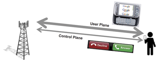
    Control plane refers to the use of cellular signaling channels as the transport mechanism for the assistance data and position information. User plane refers to the use of traffic channels (see Figure 1). When you get a phone call, the control plane makes your phone ring. When you browse the web you are using the user plane.

    Figure 1. Control plane is used for signaling purposes, user plane for transferring user data.
    Figure 1. Control plane is used for signaling purposes, user plane for transferring user data.

    Signaling channels are not designed to transfer large amount of information, so it is important for 3GPP and 3GPP2 to make the protocols efficient and save bandwidth while maintaining the best performance. Cellular traffic channels are designed to transport much larger amounts of data and thus the bandwidth restrictions are less important than in the control plane case; OMA typically addresses richer GNSS features for Location Based Services (LBS). This is why network operators often support emergency call location using control plane, leaving the user plane for commercial applications. It is also a very good way to separate emergency traffic from LBS traffic so that the former is never compromised by lack of capacity coming from heavy use of commercial location applications.

    Two different types of assisted GNSS have been standardized, known as MS-based and MS-assisted in Global System for Mobile Communicatios (GSM) and code-division multiple-access (CDMA) specifications, and as user-equipment (UE) based and UE-assisted in Wideband Code Division Multiple Access (WCDMA) specifications.

    MS-assisted refers to the case where the mobile device equipped with a GNSS receiver does not compute its own position but it is instead computed in a location server in the operator’s network. Assistance data is sent to the mobile device to help acquire satellite signals faster. Remember that GNSS signal acquisition involves a three dimensional search (satellite, frequency and delay) that requires intensive signal processing. So assistance data is sent in the form of visible satellites including expected delays and expected Doppler shifts. These values are provided at a reference time and relative to an approximate location for the subscriber. The approximate location typically comes from the location of the serving cell tower. The reference time, but not the approximate location, is normally included as part of the assistance data. After a certain number of satellites are acquired, measurements are sent back to the location server for it to compute the subscriber position. GNSS measurements for each satellite include the measured delay, measured Doppler frequency and an estimation of the signal power to noise ratio. Assistance data in MS-assisted is referred to as “acquisition assistance”. It contains the minimum information so it is very efficient in bandwidth. See Table 1 for an exact bit count of the GNSS acquisition assistance. This table will be used as an example throughout this paper. In this particular example, it is assumed that assistance data is sent for 16 satellites.

    Table-1

    MS-based refers to the case where the GNSS-enabled mobile device computes its own position locally. A different set of assistance data parameters are sent to the device to help it acquire the GNSS signals as well as calculate its own geographical location. Measurements are processed by the mobile device internal circuitry until the locally computed position is deemed accurate enough to meet the requirements received in the location request or a timeout is reached. Location information (latitude, longitude, altitude) is then sent back to the network in response to the location request. Assistance data in MS-based consists, at a minimum, of three elements: an approximate location (coming from the serving cell), an approximate time (accurate to a few seconds) and a description of the satellite orbits and clock errors referred to in the specifications as navigation model. See Table 2 for an exact bit count of the GPS assistance data in MS-based. The GNSS receiver uses the approximate location, the approximate time and the navigation model to estimate the expected delays and Doppler shifts of the visible satellite and thus proceed to the acquisition of satellite signals very much like in the MS-assisted case. Satellite measurements (code delays in the simplest implementation) and navigation model are used to calculate the receiver’s own position as explained below.

    Table-2

    Advantages of MS-Based over MS-Assisted

    We can see from Tables 1 and 2 that the amount of data used in MS-based i
    s significantly larger than that of MS-assisted, in fact by a factor of seven! So why do some operators still decide to use MS-based over MS-assisted? The answer is there are noticeable performance advantages when using MS-based. An in-depth description of these advantages is out of the scope of this paper; but we will provide descriptions of what we see as the three more important ones.

    Better Estimate of Position Accuracy. The first advantage lies with the fact that in MS-based mode the mobile device has a much better knowledge of the estimated accuracy of the position that it has computed internally. This was implicitly mentioned in the description of the MS-based and MS-assisted method above when we explained that in MS-assisted mode, the mobile terminal sends the measurements after a sufficient number of satellites (with certain range uncertainties) have been acquired. This is precisely the problem, what is a sufficient number of satellites? It is not easy to know for the mobile receiver because it does not know what positioning algorithm or what satellite subset the location server will use in its calculations. As such, it is more difficult to guarantee the quality of service of the position in the MS-assisted method. One could perhaps argue that the mobile receiver has an idea of the satellite geometry based on the Azimuth and Elevation fields (see Table 1) and therefore can perform a more educated estimation than just using the number of satellites and their associated uncertainties. This argument will only be valid if the mobile device knew exactly what the satellite subset is that the location server will employ in its position computation. Different satellite subsets yield different estimated accuracies. In addition to this, azimuth and elevation fields are optional in other positioning protocols such as Radio Resource Location Protocol (RRLP) and Radio Resource Control (RRC) and are also quantized with a value of 11.25 degrees, which deems them practically useless to quantify the satellite geometry in the critical cases where the dilution of precision (DOP) values are large.

    Kalman Filter. The second advantage comes from the use of sophisticated navigation filters (for example, Kalman filters) by all GNSS manufacturers. In the MS-based method, the final position estimate that is sent to the network is computed using consecutive sets of measurements that help the position converge using the receiver dynamic model to smooth the resulting positions for greater accuracy. Conversely, in MS-assisted mode, the position computation engine only has access to a single set of measurements and therefore cannot employ sequential navigation filters.

    Coarse-Time A-GNSS. The third advantage is perhaps the more difficult to grasp. It has to do with the fact that most (if not all) A-GNSS location servers only provide reference time information that is accurate to within a few seconds. On the other hand, for classical GNSS position computation, knowledge of absolute time accurate to a few milliseconds is required. Typically, it is the task of the GNSS receiver to decode the accurate satellite time information that comes modulated on the GNSS signals as part of the navigation message. However, in environments where satellite visibility is impaired, such as indoors, the satellite signals may be so low that the timing information cannot be decoded from the satellite due to excessive Bit Error Rate. In these situations, the absolute time can be set as an additional state that to be solved as part of the complete navigation solution therefore increasing the position yield in of the GNSS receiver in difficult environments. We refer to this technique as coarse time A-GNSS.

    There is no technical reason why this technique could not be implemented in a location server in the operator’s network as opposed to the mobile device itself. However, for this technique to work properly, the mobile device should indicate to the location server whether or not it has successfully decoded the time from the satellites signals (or perhaps other sources). This is normally done by setting an associated time-uncertainty value with the time reported with the GPS measurements. There are some 3GPP specifications (for example RRC prior to R7) that do not support this parameter so they have hindered the adoption of the coarse time A-GNSS technique in MS-assisted mode.

    Continuous Navigation. By delivering ephemeris data (good for several hours), MS-based techniques have an advantage over MS-assisted for continuous navigation. This advantage is not addressed further in this article, where we are focused only on first fixes.

    Single-Shot MS-Based Method

    We present a brief reminder of how GNSS positions are computed in order to determine what assistance data is strictly needed for a mobile terminal to compute its own location. We will use a simple least squares algorithm for simplicity but the conclusions are extensible to the cases of other positioning algorithms such as Kalman filters.

    The observation equations are typically linearized around an approximate location. They can be easily presented in matrix form as:

    Δ y = A Δ x

    where Δ y is a column vector [m x 1] containing the difference between the predicted and measured pseudo-ranges for the m satellites measured by the GNSS receiver. The predicted pseudo-ranges can be obtained using the acquisition assistance data (codePhase and intCodePhase fields.)

    Δ x is a column vector [4 x 1] containing the change in the “state” from the approximate position. The state has four unknowns x, y, z and b. x, y, and z are the change in the local East (longitude axis), North (latitude axis) and Up (altitude axis) coordinates from the reference position, b is the common mode error (mostly from the internal receiver clock error) in distance units.

    A is an [m x 4] matrix, the first three elements in each row ux , uy , uz are the coordinates of the unit vectors from the receiver to the satellite, the last element is a 1 for the common mode error. A is sometimes referred as the geometry matrix.

    Eq-1-Salas

    Coordinates of unit vectors can be written as a function of the azimuth and elevation of each satellite. Simple trigonometry yields:

    ux = cos (el) * sin (az)

    uy = cos (el) * cos(az)

    uz = sin(el)

    In the coarse-time case there will be a fifth column of A containing the range rates, which are provided in the MS assistance data.

    The goal is, of course, to determine the change in the state (our unknowns). Using simple least squares

    Δ x = (AT A)–1 AT Δ y

    we can easily determine Δx. The coordinate changes in Δx (delta position) will be applied to the approximate location to obtain the new position.

    Assistance Data Required

    To re-cap from the previous section, we have seen that to compute Δx we need:

    • Expected pseudo-ranges for satellites in view (from acquisition assistance)
    • Measured pseudo-ranges (from the GNSS receiver)
    • Azimuths and Elevations for the geometry matrix (from acquisition assistance)

    It would seem that if the mobile device receives acquisition assistance and measures the pseudo-ranges for a few satellites, it has everything that is required to compute a position (or at least a delta position) inside the GNSS mobile device. The delta position is relative to the position used to compu
    te the acquisition assistance. Have we achieved our goal of computing position inside the mobile device with acquisition assistance? Not quite. Let’s now look at the acquisition assistance data in more detail.

    We explained that we obtain the required expected pseudo-ranges from the acquisition assistance fields codePhase and intCodePhase. The codePhase field is defined with a resolution of one GPS chip, equivalent to 300 meters. Recall that we subtract the expected pseudo-range from the measured pseudo-range before we use the measurements in the position solution so this means if our expected pseudo-range was in error by, say, 150 meters because of the low resolution of this field, this is similar to making a measurement error of that amount, which of course will cause an unacceptable position error. This means the resolution of the codePhase field would need to be increased to be able to compute position. For a resolution of 2 meters, 8 more bits would need to be added.

    The second topic of interest relates to the azimuth and elevation fields. These are needed to construct the geometry matrix A. As mentioned before, in 3GPP location protocols the azimuth and elevation of the acquisition assistance element are defined with a resolution of 11.25 degrees. Sines and cosines (needed to calculate the coordinates of the unit vectors) with such large angle errors will also yield large position errors. In Long-term Evolution Positioning Protocol (LPP), the situation has improved with the resolution being 0.7 degrees.

    In an effort to quantify how the angle quantization affects the position error, we have run simulations that plot the 95 percentile of the HDOP error as a function of the angle error in azimuth and elevation (see Figure 2.) HDOP is proportional to the position error so this seems to be a reasonable choice. N is the number of satellites used in the simulations. As you might expect: the fewer the satellites the greater the effect.

    Figure 2. HDOP error vs Az/El error. We use HDOP as a proxy for the expected position error: if the HDOP changes by 10 percent, we expect the position error to change by a similar amount.
    Figure 2. HDOP error vs Az/El error. We use HDOP as a proxy for the expected position error: if the HDOP changes by 10 percent, we expect the position error to change by a similar amount.

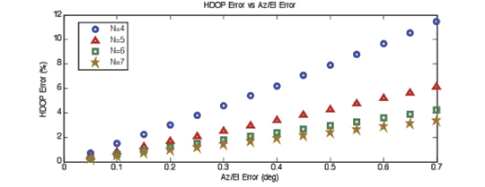
    We can see from the plot in Figure 2 that for an angle resolution of 0.7 degrees as currently defined in LPP, the 95 percent HDOP error is under 12 percent. If we wanted to make the worst error (N=4) under 2 percent, we can see that the resolution should be increased to 0.1 degrees. In order to meet this goal, 3 more bits would need to be added to both the azimuth and elevation fields in the acquisition assistance.

    Another effect that must be noted is the possible change in the azimuth and elevation from the time the assistance data is received to the time the receiver computes its position (or delta position). In an emergency call scenario, typically we assume this time will not be greater than 24 seconds. Note the total allowed response time for an E-911 call is 30 seconds, including call establishment and network latencies. Simulations based on satellite geometry show that the worst-case effect is approximately of the same order of magnitude as the angle resolution discussed above, and therefore its impact in HDOP is just a few percentage points in the case of N=4.

    At this point we seem to have everything we need to compute positions (or delta positions) inside the mobile terminal with the same acquisition assistance used in MS-assisted; albeit with slightly higher resolution in some of the fields.

    To facilitate the comparison with MS-assisted and MS-based methods, Table 3 summarizes the exact bit count needed for Single Shot MS-based.

    Table-3

    Optionally, if an absolute position is required in the mobile device instead of delta position, it would also require the approximate position (reference location) to be sent along with the rest of the assistance data (acquisition assistance, reference time). However, the MS-based performance advantages listed above can all be realized without the reference location, using only delta position. This is why we have not included Reference Location as an element that is needed for Single Shot MS-based.

    Conclusions

    We have seen that Single Shot MS-based can be used to enable all the MS-based performance advantages with, essentially, the same assistance data that is used in MS-assisted. Minimal additional bandwidth is required due to the increased resolution of some of the fields. Single Shot MS-based is therefore the best option for network operators that deploy A-GNSS based emergency location.

    Not only does MS-based require significantly more bandwidth than MS-assisted (~ 7x) or Single Shot MS-based (~ 6x); but the absolute difference will increase with additional GNSS satellites such as GLONASS, SBAS, QZSS, Compass, and Galileo. Imagine all navigation models have to be sent for all satellites in view and for all GNSS constellations! Acquisition assistance can easily be made generic for every GNSS constellation since it is just “range and Doppler” and, in fact, this is the way it has been conceived in LPP where the dynamic ranges for all parameters are no longer restricted to GPS but allow other GNSS constellations.


    Javier de Salas is director of GPS product marketing at Broadcom. Previously he worked at Ashtech, Magellan, and Global Locate. He has an MS in electrical engineering from Universidad Politecnica de Madrid.

    Frank van Diggelen is chief navigation officer and senior technical director for GNSS at Broadcom. He is also a consulting assistant professor at Stanford University and is the author of A-GPS: Assisted GPS, GNSS and SBAS. He holds more than fifty issued U.S. patents on A-GPS and has a Ph.D. in electrical engineering from Cambridge University.

  • Webinar Follow-up Q&A: SBAS, DGPS or Post-Processing? Which Should You Use?

    Last week, I conducted a webinar along with Dr. Michael Whitehead titled “SBAS, DGPS or Post-processing? Which Should You Use?” It was one of the best webinars I’ve conducted to date. More than 600 people registered. We barely squeezed it into 65 minutes and could have kept going for the better part of two to three hours, given the subject matter to cover and the number of questions we received before and during the webinar. Thank you for attending, if you did. If you weren’t able to you, can download it by registering here. After registering, you’ll be provided a link to download it.

    I knew that only having 65 minutes would be a serious issue for the webinar because the discussion could take many worthwhile tangents. And it was. But alas, we stuck to the presentation agenda, stayed on schedule, and were able to address several audience questions.

    We had a lot of questions before and during the webinar. As customary, I’d like to address some of those as well as present the poll results here. First, the poll questions and results with accompanying pie charts to illustrate the results.


    Poll #1: For those of you who use post-processing, what are the reasons you use it?

    Total votes: 117

    Gakstatter comment: This is an interesting spread with no clear dominating reason. Based on data I’ve seen and data we collected, I’m not convinced that post-processing is more accurate. If it is, is it worth the extra 10%, 20%, or ??% accuracy? I understand the votes for more reliable corrections. There’s something to say for reverse processing (forwards and backwards).


    Poll #2: For those of you using post-processing, from where do you access GPS base station data?

    Total votes: 129


    Gakstatter comment: These answers don’t surprise me. National and regional CORS have become very prolific in the past 10 years.


    Poll #3: For those of you who use real-time DGPS/SBAS, what is the reason you use it?


    Total votes: 110

    Gakstatter comment: These answers surprised me a little. I thought more people would vote for “less complicated.” Does that percentage of users really need corrected coordinates in the field? Why? E-mail me a quick answer if you have a chance.

    Poll #4: For those of you using real-time DGPS/SBAS, from where do you access DGPS/SBAS corrections?

    Total votes: 129

    Gakstatter comment: This answer doesn’t surprise me at all. I suspect RTK networks will increase due to their continued proliferation and different levels of accuracy offered.

    Poll #5: When I purchase GPS/GNSS equipment in the future, I will likely select equipment that utilizes the following correction method (select all that apply):

    Total votes: 144

    Gakstatter comment: This was the only multi-answer poll. People could select more than one answer. These answers were surprisingly close. That surprised me. It didn’t surprise me that SBAS was the leader. It surprised me that post-processing is still as predominant as it is. If you have a chance, e-mail me a quick explanation as to why you will use post-processing in the future.

    Before diving into some audience questions, I’d like to clarify the slide illustrating the post-processing plot shown below.

    During the webinar, we were discussing PPP (precise-point positioning) when this slide was displayed. This data was not corrected via PPP, but rather post-processing the pseudorange data, which is the equivalent of L1 SBAS and L1 DGPS. The point was to show how SBAS/DGPS accuracy compares to post-processing. In the real world, you won’t post-process 24 hours of data. Some of you will post-process only a few minutes of data per session in cases where you need to turn off the receiver and travel between points. In other cases, users will keep the receiver tracking between points, allowing reverse processing to work more effectively.

    On to the Questions


    Question #1: Will there ever be a way in which the position of a rover can become fixed by using two fixed base stations?

    Gakstatter comment: SBAS does this already. SBAS’s consist of a number of base stations within the coverage area (e.g., WAAS has 38). Data from many base stations is used to compute the correction information sent to an SBAS-enabled GPS receiver.

    I’m assuming your reasoning is to improve position integrity.

    Another method of accomplishing this is by post-processing against more than one base station or switching between DGPS beacon stations. If they differ significantly, then you might want to compare against a third base station.
    Question #2: At what point in time will the strength of the GPS signal be increased? To what strength will this occur? 500 times more powerful? What improvements in signal reception will be experienced? Indoor my house reception?
    Gakstatter comment: The GPS broadcast strength is increased with new GPS satellite model. For example, the current Block IIF satellite broadcasts the new L5 signal about four times stronger than L2C. While no one can be sure yet as to how much this will improve indoor positioning, there will be some marginal improvement in conditions where GPS doesn’t operate very well today. Also helping will be the improved code and error-correcting techniques that should make operating in difficult conditions a bit better, especially where there are a mixture of satellites with strong and weak signals.
    Also, it raises the issue of a viable L5 single frequency receiver, which should outperform the L1 C/A single frequency receivers of today.
    Question #3: NAD83, WGS84, ITRF differences, how to make the best choice?
    &nbsp
    ;
    Gakstatter Comment: I don’t think there is an incorrect choice, except maybe that NAD83 is a 2D system and will eventually give way to a 3D system, but that won’t happen in the U.S. for many years.
    Otherwise, it’s a question of matching disparate data sets. Probably the #1 question I hear from users is “why doesn’t my GPS data line up with my basemap?” The answer is almost always a difference in datums. Many papers have been written on this. Click here for a good PowerPoint presentation created by Dave Doyle of the National Geodetic Survey.
    Question #4: Are there any open source post-processing software programs available?
    Gakstatter Comment: Mike suggested looking here….http://gpspp.sakura.ne.jp/rtklib/rtklib.htm
    Question #5: If a person uses real-time correction satellites, is there a need to post-process?
    Gakstatter Comment: It’s rare that someone would do both, but not out of the question. For example, one might rely primarily on real-time corrections and record raw data for post-processing in case there is a problem receiving the real-time corrections. The opposite is true, too. One might rely primarily on post-processing and use real-time corrections as a back-up in case there is a problem with post-processing.
    Caveat emptor: There are probably datum differences between the sources of real-time and post-processing corrections. This needs to be reconciled when combining data that has used the two sources.
    Question #6: Is it possible to post-process data without using a DGPS?
    Gakstatter Comment: Yes, all that is required for post-processing is the ability to record raw observation data.
    Question #7: Are there geographic areas in the U.S. that are not covered by NGS CORS stations?
    Gakstatter Comment: No, not for pseudorange (L1) differential corrections. The distance to the base station will vary depending on where you are located and thus may affect your accuracy to some degree, but the density of CORS in the U.S. is such that you will never be more than a couple of hundred kilometers from a base station and likely much closer.
    A side note: Back in the mid-1990s, I remember experimenting with post-processing software we were developing. At that time, I tried post-processing data collected in Oregon with a base station located in Atlanta, Georgia. This was a 2,500 km baseline. It produced a result, albeit not one I would necessarily trust. The only limitation is that the two units must track common GPS satellites. With that length of baseline, it’s possible that only half of the satellites tracked may be in common.
    Question #8: What is the ideal distance range from a CORS station to your site to use post-processing?
    Gakstatter Comment: Ideally, as close as possible. The further you are from a base station, the more potential error will be introduced due to atmospheric differences between the two locations. As stated above, the density of CORS (at least in the U.S. and many parts of the world) are such that the nearest base station is quite near and likely no more than a couple of hundred kilometers away.
    Question #9: What is the trade-off between short observation time (couple of minutes) to position accuracy when using post-processing?
    Gakstatter Comment: Ok, remember we are talking about pseudorange corrections (as opposed to carrier phase). Given that the receiver has been tracking satellites for a period of time (let’s say two minutes), the observation times only need to be a few seconds for each feature to be mapped.
    For example, if you are mapping utility poles and don’t turn off the receiver between poles, you only need a few seconds (5-10 seconds) of data for each pole and average it for the final coordinate. Think about if you’re mapping a road centerline. You’ll likely record data while moving, so each second you are recording a new position.
    Question #10: What about the vertical correction? I see in the slide an antenna carried in a backpack. Is the antenna placed at ground level for point? Is there a constant correction required?
    Gakstatter Comment: Vertical accuracy is typically worse than horizontal accuracy by a factor of 1.5-2.0 due to the inferior satellite geometry, especially in areas of hilly terrain and/or trees/buildings where the horizon is blocked. Good geometry for vertical positioning requires tracking a number of GPS satellites that are low on the horizon.
    Question #11: What is the future of DGPS? I heard Coast Guard beacons were going away?
    Gakstatter Comment: The beacon stations operated by the U.S. Coast Guard are not in jeopardy and never have been. Neither have the marine beacons in the other 40+ countries that broadcast GPS corrections. However, the U.S. Department of Transportation operates 29 inland stations in the U.S. which have faced budget challenges the past few years. In April 2008, the U.S. DOT issued a policy decision to continue operating the 29 inland sites. Construction of seven sites remains that would allow the Nationwide DGPS to reach Initial Operating Capability (IOC), which would provide coverage to 99% of the continental U.S. No budget has been approved for the construction of those seven sites.


    Question #12: Can you briefly explain the difference between DGPS & RTK?
    Gakstatter comment: Here are a couple of good websites that explain each of these techniques. Essentially, DGPS is a real-time GPS positioning technique accurate to about 30 centimeters at the very best. RTK is a real-time GPS positioning technique accurate to about 1 centimeter.
    Question #13: How much time do you need to get the position from the base station for real-time DGPS?
    Gakstatter comment: Assuming both receivers are already tracking satellites, your receivers will begin using the base-station corrections as soon as the data link is made between the two.
    Question #14: Can you comment on advantages (if any) of using corrections from a network RTK service for DGPS corrections. Any advantages on eliminating base separation?
    Gakstatter comment: I’ve heard that DGPS corrections are optimized within an RTK Network. However, I need to research this a bit further to better understand the true advantages, if any.
    Whitehead Comment: A virtual base station (VBS) solution could be formed using the network. Thus differential GPS could exhibit the same advantages using such a network that RTK does (cancellation of atmosphere errors). The software would have to support this.
    Note though that if close to one of the Reference Stations in the network, it is probably best to just use the nearest Reference station as this will best cancel the atmosphere errors. When in the middle the network, the VBS solution would use surrounding reference stations to provide a good approximation of atmospheric errors and then output a correction that looked like it originated from a reference station (virtual station ) near to the users receiver.
    Question #15: What is up with PRN 135? Still on station?
    Gakstatter comment: Communication has be re-established with WAAS PRN 135 and is being tested by its owner, Intelsat, as well as the Federal Aviation Administration (FAA). See a detailed article by clicking here. The latest information I heard is that it’s currently at 93°W longitude undergoing testing. If the testing is successful, it will be re-located back to 133°W longitude and brought back into WAAS service. A timeline has not been published, but I’m guessing within the next 30-60 days.
    Question #16: We used to hear that your point accuracy degraded as the distance from the base station increased. One reason we used to post process. Is this still a factor?
    Gakstatter Comment: Due to advancements in GPS technology, it’s not as much of an issue as it used to be. I think this is illustrated in the results we achieved in our 24 hr test data.
    Ten years ago, it would be hard to find a GPS L1 receiver that would receive DGPS corrections from a beacon station 184km away and still achieve sub-meter horizontal accuracy at the 95% confidence level.
    I’m not saying the distance is negligible. There still the issue of tropospheric, ionospheric and satellite orbit errors as you move farther away from the base station. But, it’s certainly less of a factor than it was before.
    Whitehead Comment:
    Question #17: If we use WAAS correction, does it really help to try to use a post-processing type of software afterward? So far we just use WAAS correction.
    Gakstatter Comment: One of the reasons we collected data using several sources of real-time corrections and also showed the results of post-processing was to illustrate the differences between the two.
    If you follow proper procedures, there’s no reason to think that accuracy obtained using WAAS will differ significantly from accuracy obtained using post-processing. This is assuming that you’re using a single-frequency GPS receiver and post-processing using pseudorange corrections and not carrier-phase processing. Some receivers like the Trimble GeoXH are actually dual-frequency receivers and so data from it will likely surpass the accuracy of WAAS if you’re using its dual-frequency antenna and equivalent post-processing software.
    By proper WAAS procedures, I mean letting it track for five minutes upon initial start-up to allow it to download a current ionospheric map.
    Question #18: Does SBAS use 1 receiver and no base station? Expensive?
    Gakstatter Comment: SBAS uses 1 receiver and a lot of base stations. You just don’t have to pay for the SBAS base stations (or to use them.) The signal, like GPS, is provided free of charge.
    SBAS consists of a network of base stations (WAAS has 38) and communications satellites that broadcast corrections to users on the ground (or aviation users in the air).
    Question #19: How far north in Alberta is WAAS coverage available and useful?
    Gakstatter Comment: The primary concern would be visibility of the WAAS GEO satellite that broadcasts the correction data. Following is a map that illustrates the coverage. The contour lines are degrees above the horizon for which the two WAAS GEO satellites are visible.
    Solid line = PRN 138, Dashed line = PRN 133
    Question #20: Do you have any comments about CDGPS in Canada/US?
    Gakstatter comment: Sadly, the CDGPS service is being decommissioned March 31. You can read about it here. 
    Question #21: I am hearing from my state specialists (NRCS) regarding the LightSquared issue. We are advising working through the PNT ExComm and our cooperating partners.
    Gakstatter comment: This is a potentially serious issue for GPS users. Click here for the latest news as of February 1.
    Question #22: Where do you find the DGPS beacon station list and what is available to you?
    Gakstatter comment: I’m not sure if this is 100% complete, but it’s the most complete list I’ve seen. Click here.
    Question #23: Are most mapping-grade GPS receivers (for example Trimble GeoXh) equipped off the shelf to receive beacon signals?
    Gakstatter comment: Some receivers are equipped off-the-shelf, others are not (such as the GeoXH) and require additional hardware.
    Question #24: In which areas is it possible to use corrections from OmniSTAR?
    Gakstatter comment: Click here to view worldwide maps of OmniSTAR coverage.
    Question #25: Was the Garmin set to WAAS?
    Gakstatter comment: Yes, during the 24-hour data collection session, the Garmin unit was receiving WAAS 100% of the time as far as we could tell. The purpose of the 24-hour test period was to able to randomly sample data during that period to arrive at the accuracy statistics we presented. I randomly sampled the dataset several time
    s (averaging 10 seconds worth of positions 200 times) and the results were consistent with what we presented.
    Question #26: How does post processing account for ionosphere or troposphere errors if receiver is geographically far away from the base station? If not, does DGPS and WAAS provide better accuracy and integrity?
    Whitehead comment: Post Processing using a CORS station would take the nearest station and do differential GPS which cancels common errors in ionosphere and troposphere (ionosphere and troposphere are both temporally and spatially correlated) so if the CORS station is close, there will be good cancellation. If the receiver is far, the algorithms could use a troposphere model to account for the differential troposphere (as was done in the Presentation for BeaconT) and this would probably cancel troposphere so that remaining errors were sub-decimeter level. Differential Ionosphere errors could also be easily modeled with good results. It is likely that the performance could be made to easily surpass SBAS.
    DGPS would suffer from the same effects as does post processing, and maybe even more so since a model of differential atmosphere errors is rarely used. SBAS will likely provide better accuracy in situations where you are far from a base station.
    Question #27: What is Beacon T?
    Gakstatter Comment: While collecting data to present at the webinar, Mike noticed there was a bias in the beacon measurements. The beacon station is located ~184km away at about 7,000 ft elevation while the test site was at about 1,000 ft elevation. Initially, Mike wasn’t modeling the troposphere difference between the base and rover.
    To model the troposphere, Mike said he used a troposphere model to figure out troposphere in both locations, and then subtract the two. Although the models are not necessarily that accurate in an absolute sense, the differential tropo between the two locations is fairly accurate using the models. This differential tropo allows the receiver to correct the tropo in the base station differential to make it appear as if it originated in the rover location. Mike said he could’ve done the same for the ionosphere, but he didn’t since that is it usually less of a factor. After using the modified tropo model (Beacon T), the height bias was around 1/2 meter, which could be attributable the ionosphere. The horizontal bias is small, as you can see in the results.
    Using this troposphere model resulted in a significant improvement over the original solution.
    Question #28: Why is VBS better than WAAS?
    Gakstatter Comment: It surprised me too. The receiver used was the same that was used for beacon and WAAS. I contacted OmniSTAR for their opinion.
    John Pointon of OmniSTAR responds: “There have been incremental improvements in the VBS service over the years, mostly improvements in modeling and processing. We have added two or three extra reference stations but that hasn’t been the most critical improvement, just helped in some specific areas. These, combined with the relatively benign solar environment, result in VBS accuracy which, although not equivalent to our dual-frequency and multi-system solutions, is consistently better than either Beacon or WAAS.”
    Whitehead Comment: In the past, we’ve seen similar performance from both OmniStar VBS and WAAS.  Different atmosphere conditions and different locations can affect the performance of both. We’ve seen situations where WAAS is better.  It is probably fair to say that OmniStar is more focused on accuracy, whereas WAAS is focused on integrity.  It may be wise to do a comparison in the particular area where you operate.  Note, however, that in the US, OmniStar is referenced to NAD83 whereas WAAS is references to ITRF so positions reports between the two can differ by several meters.
    Question #29: When I look at your scatter plot, I have to ask if short-term point averaging is really effective at achieving more accurate positions?
    Gakstatter Comment: I think it’s well accepted that you are wasting time by occupying a point for 180 seconds. That said, there’s something to be said for letting the receiver track satellites for a period of time (1-2 minutes) before storing 5-10 seconds of data. Of course, if the receiver is already tracking satellites, then it’s not necessary to wait. The idea is to let the measurements settle down and take advantage of carrier-phase smoothing if the receiver uses that technique.

    Question #30: Could you go into PPP a bit more? How does it work?

    Gakstatter Comment: We opened a can of worms by discussing PPP. It’s an entirely different subject that I will cover in a future article. In the meantime, you can read Dr. Richard Langley’s article on PPP here.

    Question #31: How do you test the accuracy of SBAS collected data?

    Gakstatter Comment: In the U.S., it’s easy. Find a local survey mark using the National Geodetic Survey website. Printout the ITRF coordinates of the survey mark. If they aren’t on the datasheet, you can convert from NAD83/CORS96 to ITRF using the HTDP program. Compare the coordinates output by your GPS receiver to the coordinates of the survey mark.
    If you’re located outside of the U.S., look for a similar government agency in your country that maintains a record of survey marks. It’s vital that you are comparing coordinates referenced to the same datums.


    Question #32: Will there be any disadvantage if we use a EGNOS corrections in Kuwait, if we receive EGNOS?

    Whitehead Comment: Kuwait is outside the EGNOS coverage zone, so satellites to the south may not even have Clock and Orbit correctors available, which means the Receiver could not compute a correction for these satellites.  Unless the receiver can mix differentially cor
    rected ranges with non-differentially corrected ranges, it would likely drop the satellites in the south that had no corrections. This would then reduce PDOP and thus accuracy. Mixing differentially corrected ranges with non-differentially corrected ranges may give worse accuracy than no corrections at all since the SBAS system may have clock or other biases relative to GPS.
    By the way, I wish the SBAS providers would get together and share data so that they each could provide world-wide orbits and clocks. Then it would matter less if you were outside the coverage area.
    Gakstatter Comment: I’ve heard that EGNOS is planning an expansion to the south and east, so Kuwai may eventually be within the EGNOS coverage footprint. Also, you’ll want to monitor the progress of India’s GAGAN system, which is a similar SBAS. It’s possible you might fall within the GAGAN extrapolated footprint for non-aviation users.

    We covered most of the questions posed by the audience. If we didn’t address yours or didn’t provide a complete enough answer for you, please e-mail me and I’ll do my best to answer you.
    As I mentioned above, we had quite a few questions about PPP. It’s a technology that’s worthy of further coverage and discussion. Look for a future article on it.
    Thanks, and see you next time.
    Follow me on Twitter at http://twitter.com/GPSGIS_Eric


  • Where the 3D Scanning Action Is, and Keeping It Simple

    I’m preparing for some conference presentations I’ll be giving in a couple of weeks. One of the subjects I’m covering is spatial data transformation, or traditionally known as ETL (Extract/Transform/Load) tools. I’ve written many times before that in the geospatial industry, data is the fuel. We, as users, have access to some amazingly powerful GIS software tools.

    Clearly, the geospatial enabler is data. Without it, it’s like having a fishing pole without a pond; a tool without a purpose.

    If you look at emerging geospatial technologies, where’s the data coming from? Yes, crowd-sourcing, GPS/GNSS, and imagery are, and will continue to be, volume sources of geospatial data.

    From an infrastructure perspective (civil engineering), 3D laser scanning is a particularly interesting source of high-volume geospatial data. Ground-based and airborne 3D scanners create insanely huge volumes of data. Although an emerging technology, these scanners (LiDAR technology) have been around for many years.

    I recall using this technology on projects 8 or 9 years ago to scan accident scenes and infrastructure such as bridges. The scanning time was amazingly efficient. In some cases, the scanning data collection sessions were done in a couple of hours. During that period, literally millions of data points were collected. For the first time, the ratio between labor expended on data collection and labor expended on data processing was extremely skewed towards data processing, and that was the headache.

    While scanning time was very short, data processing time to produce a deliverable was brutal, literally taking weeks. Granted, that was 8 or 9 years ago. Advanced software tools have made data processing more efficient today, but dealing with huge volumes of data is still a challenge. Some people say that scanning may eventually replace traditional surveying equipment that shoot and record one coordinate at a time. A land surveyor, on a really strong day, may be able to shoot and record upwards of a 1,000 coordinates. With a scanner, that same person could shoot and record millions of points in a day.

    Data, Data, Data
    Ground-based and airborne LiDAR technology are clearly on the uprise. Last year, while most conferences were struggling to maintain the 2009 levels, even failing, the SPAR 2010 3D imaging conference was up 23%, according to their reports. The International LiDAR Mapping Forum conference also reported record attendance figures. Although the conferences are still in niche-mode (less than 1,000 attendees), the growth is steady.
    If you step back a bit and look at the big picture, the game is in data processing. Yes, equipment manufacturers will crank better and cheaper scanners, but turning those 3D point clouds into useful products is where the action is.
    You can see this with SAFE Software’s recently announced FME 2011 product. While historically focused on GIS and CAD interoperability, SAFE obviously sees the upside in the point cloud business as a major part of FME 2011 is focused on dealing with the massive amounts of data created from 3D laser scanning.
    Keeping it Simple
    Changing gears…
    With all this geospatial technology advancing faster than a rabbit on a motorcycle, it’s hard to slow down and look at the simple uses of GIS that still offer a lot of value. As much as most of us are pushing hard to implement more and more spatial data technology, it’s just as important that we introduce people to GIS, even a very simple version of it.
    This week, a reader asked me about the best way to display a map from a bunch of lat/lon coordinates (little or no attributes) in a spreadsheet. No complex attribute tables, no strange map projection, just a spreadsheet of lat/lon coordinates.
    This challenge gave me reason to revisit Esri’s freely available ArcExplorer software. It wasn’t my first choice, but it’s where I‘ll likely end up. I haven’t touched ArcExplorer (I know that’s not the name of the current software, read on) for quite some time (as in a couple of years or more). I use ArcGIS, AutoCAD and a half-dozen other spatial data software tools.
    When presented with the challenge, my first inclination was to push her towards arcgis.com in order to steer her away from having to download, install and maintain desktop software. No go. After a quick post to a support group, I’m told there’s not an easy way to add this data to an arcgis.com map. My other thought was Google Earth. Naah.
    I subscribed to Google Earth Pro for a year and it really is sort of cheesy, to me. Maybe it’s because my view is distorted from my experience with GIS software in the past, but it seems to me that Google Earth is still primarily eye-candy, and what I really wanted was an easy-to-use, light-weight GIS. However, I do hope that they continue pushing that technology forward.
    All along, I thinking my ultimate back-up plan would be to recommend ArcExplorer. I went to download it and remembered it’s now upgraded to ArcGIS Explorer. I remember reading and posting that news awhile back, but hadn’t taken the time to download and preview it. It’s a much different animal than ArcExplorer, and I like what I see so far. I haven’t tried to import any data yet, but from the menu selection, I can see it will accept the simple ones such as shapefiles, raster imagery, ASCII, and GPS exchange files. Most simple data sets can be converted to one of these formats using freely available software tools.
    ArcGIS Explorer Opening Screen
    This will be an interesting experiment, and one I will update you on, likely next week, as I try it with a sample data set from the reader.
    I really like the opportunity to introduce someone to GIS, even at just a simple level because I believe will open their eyes to other possibilities in the future. It empowers them to think more GIS-centric.

    Thanks, and see you next time.

    Follow me on Twitter at http://twitter.com/GPSGIS_Eric

  • Remember How Slow Dial-up Was? That’s Where GPS Is Today

    It’s not often that I share content between the two newsletters I write (Geospatial Weekly and Survey Scene), but this week is one of them. Europe’s version of GPS (named Galileo) will have a profound effect on the geospatial industry in the future. In the past, I’ve written about how cheap accurate positioning is going to get. Europe’s Galileo is a big step in that direction and an important factor in making it happen faster than GPS alone.

    Being able to collect accurate geospatial data, whether it’s a utility pole, a wetland monitoring well, or a catch basin, will be infinitely easier, cheaper, more efficient and more accurate than it is today. Therefore, with accurate data becoming much more available and accessible, what do you think will happen to geospatial applications?

    To answer that question, I’ll use an analogy that we can all relate to.

    Remember in the early ’90s when the average person accessed the Internet via a dial-up connection? You were lucky to get a connection speed of 56 kbps, and more likely it was 28.8 kbps or 14.4 kbps. At that speed, there is only a limited amount of activity one could do on the web. Geospatial professionals and geospatial users are particularly heavy users of Internet bandwidth. GIS vector data, imagery, and maps in general create sizable files. Can you imagine the typical geospatial professional trying to accomplish their daily tasks using a 56 kbps dial-up connection to the Internet?

    Think about how much economic benefit the world has gained with the introduction and proliferation of broadband (cable, DSL, high-speed wireless, etc.) Internet connectivity. Not only are we more efficient with broadband connectivity, we are more enabled. Take one example, cloud computing. That emerging technology is totally reliant on broadband Internet connectivity. If only dial-up existed, cloud computing wouldn’t exist.

    To put GPS/GNSS (Galileo, GLONASS, etc.) in perspective, we are still in the “dial-up” phase. Even though GPS/GNSS is a multi-billion worldwide industry today, imagine what it will be when it enters into the “broadband” phase. Try to imagine the tremendous number of applications that will be enabled when GPS/GNSS is orders of magnitude less expensive and more accurate than it is today. Then, think about how much of the GPS/GNSS industry has a geospatial component to it.

    The following is lifted from my Survey Scene newsletter we published this week. It describes the path to cheap accuracy and how Galileo will help us get there faster.


    2011: The Year for Galileo

    January 18, 2011

    By Eric Gakstatter

    Back in December 2006, I wrote about the momentum of Galileo (Europe’s planned satellite navigation system) in an article discussing GNSS trends. Galileo been discussed off and on for well over a decade and was a hot topic for a number of years. In fact, back around 2001, the U.S. really didn’t want the European Union to embark on the project. While there was not a clear policy against Galileo, certainly the sentiment was questioning the creation of another satellite navigation system when GPS already exists that’s free for everyone to use. Ok, it probably wasn’t that simple, but you get my point. No bueno from the U.S. at that time.

    The following is an EU slide that illustrates why the EU wants to develop its own satellite navigation system similar to GPS:


    Source: European Commission – Montpellier, France – October 2010

    Then, in 2004, the U.S. government abruptly changed its tune. It really doesn’t matter why and I’m not sure I’d believe the answer if I was given one, but President George HW Bush instituted a new policy that encouraged international cooperation. The U.S. SPACE-BASED POSITIONING, NAVIGATION, AND TIMING POLICY issued in 2004 stated, among other things, that the United States shall:

    “Seek to ensure that foreign space-based positioning, navigation, and timing systems are interoperable with the civil services of the Global Positioning System and its augmentations in order to benefit civil, commercial, and scientific users worldwide. At a minimum, seek to ensure that foreign systems are compatible with the Global Positioning System and its augmentations and address mutual security concerns with foreign providers to prevent hostile use of space-based positioning, navigation, and timing services;”

    Also in 2004, the U.S. and European Union signed the landmark GPS-Galileo Agreement that established a basis of cooperation. This was great news for the GNSS user community. More satellites and more signals usually equates to better performance.

    The next policy update after 2004 was last year (2010) and it was simply titled “NATIONAL SPACE POLICY“. The sentiment regarding international cooperation was the same, if not leaning more towards cooperation:

    “Engage with foreign GNSS providers to encourage compatibility and interoperability, promote transparency in civil service provision, and enable market access for U.S. industry;”

    After the 2004 GPS-Galileo policy was published, the question from the civil user community was, “When are we going to have satellites in orbit broadcasting signals we can use?”

    The answer to that question wasn’t easy, and took longer to answer than anyone predicted, including myself.

    Now, we have the answer.

    Unlike GPS and GLONASS, Galileo is a civilian
    project, not a military-funded one. I’m not saying GPS and GLONASS were easy to fund, but the core application was defined (military use), and the funding required to develop and maintain GPS and GLONASS is drawn from the military budget. Furthermore, the European Union is comprised of 27 member countries. The political dynamics are, obviously, very complex.

    The Galileo funding modeling initially was to be a public-private partnership (PPP). Part of it would be funded with public money and part of it would be funded by a consortium of companies. But, that wasn’t so easy. How much funding would each contribute? What’s the return on investment? How would it generate revenue? Would there be a tax receiver sales? Would there be a user charge?

    We’re not talking about small sum of money. We’re talking about several billion Euros just to get it off the ground.Think about it, how much money has the U.S. military spent to develop GPS? $30-$35 billion for development, deployment and long-term maintenance. Granted, Galileo will cost a lot less than that, but it’s still a healthy sum that no company would be willing to gamble without a solid return-on-investment (ROI) argument.

    Eventually, the PPP (Private-Public Partnership) funding model was abandoned and in late 2007, and as described in a January 2008 GPS World article:

    “European officials responsible for the EU budget said they had found funds for Galileo, proposing to draw unused money originally earmarked for natural resources programs this year and next. The move would provide some €2.4 billion ($3.3 billion) for Galileo — the budgetary shortfall left with the dissolution of the public/private partnerships — over the course of the next six years. The following month, European parliamentarians agreed with the plan, but felt it didn’t go far enough. They boosted proposed funding for Galileo, increasing the money set aside for the program in 2008 to €739 million ($1.06 billion), up from the much more modest €151 million under the transport officials’ original proposal for next year.

    Not all were sold on public funding for Galileo. But in November, European officials said they had ironed out their differences. At the 11th hour came heated debate about how Galileo funding and contracts would be awarded among member states and their respective aerospace companies. Eventually, a final accord was reached. Europe anticipates spending €3.7 billion on Galileo through 2013.”

    (Updated figures: €2.1 billion for IOV and €3.4 billion for FOC)

    That was three years ago. The EU folks have been working hard since then, but talk is cheap and people stopped talking about Galileo with the exception of a few information spikes here and there. There was nothing else to say until now.


    2011 is the Year for Galileo

    Galileo will likely meet a major milestone this summer, launching their first two satellites for in-orbit validation. But unlike the two Galileo test satellites already in orbit (GIOVE-A and GIOVE-B), these satellites will be part of the planned 30-satellite operating constellation.

    For you Galileo naysayers, the EU is past the point of no return. Eighteen satellites are contracted. There is no reversing the process. And, if I were to place a bet, it’s very unlikely to stall at 18. That would be sort of like building a structure, but not finishing the interior.

    Although I haven’t seen a detailed launch schedule or control segment plan, the latest Galileo public document I’ve read (European Commission – Montpellier, October 2010) presents the following timeline:

    2011/2012 – In-Orbit validation: Four IOV satellites and ground segment (based on European Commission presentation from October 2010).

    2014/2015 – Initial Operating Capability for early services — 18 satellites (based on European Commission presentation from October 2010).

    2019/2020 – Full Operating Capability — 30 satellites (based on mid-term review released January 18, 2011)


    2014 Will Be the Year of Cheap GNSS Accuracy

    I believe the magic year for GNSS will be 2014. That’s when GNSS receivers are going to be very interesting.

    Why?

    It’s no secret that I think the new L5 signal is a game-changer. Last summer I wrote an article titled “What’s Going to Happen When High-Accuracy GPS is Cheap?”  It’s all about L5.

    L1/L5 dual-frequency receivers are going to be cheap, and accurate. Today, dual-frequency (L1/L2) receivers are thousands of dollars. L1/L5 receivers will be a fraction of that cost because open signal specifications will lead to increased competition.

    As I mentioned in the article last summer, the GPS Directorate is planned to have 24 satellites broadcasting L5 by 2019. The beauty of Galileo is that it can cut that time in half and make it happen by 2014, only three years from now. Here’s how.

    Since Galileo supports L1 and L5 similar to GPS, you only need 12 x GPS satellites broadcasting L5 and 12 x Galileo satellites broadcasting L5 to have something close to 24 satellites broadcasting L5.

    The BIG question is if the U.S. and EU will coordinate orbit slots so the 12 x GPS and 12 x Galileo satellites are in a somewhat optimal 24-slot constellation instead of an uncoordinated configuration. The civil economic benefit from taking advantage of L5 as soon as possible would be substantial. Just this week, the EU issued a reportstating that 6-7% of the GDP of EU countries is dependent on satellite navigation. Better accuracy enabled by L1/L5 will spur a mind-boggling number of new applications that will further broaden the GNSS user base and economic impact. It would also stimulate GNSS receiver development from a much broader range of GNSS receiver designers than we see today.

    With a combined GPS/Galileo constellation, not only will accuracy become cheaper, but availability will increase significantly. The new GPS 24+ 3 configuration is certainly a big help for high precision users with respect to availability. Can you imagine how much precise positioning availability will improve when 18 Galileo satellites (not to mention 30) are added to the mix? Last summer, the EU-U.S. Cooperation on Satellite Navigation Working Group C published a report entitled “Combined Performance for Open GPS/Galileo Receivers.” The report succinctly draws the following conclusion, with which I wholeheartedly agree:

    “The studies demonstrate and quantify the improvements that can be expected when using GPS and Galileo open services in combination under different environmental conditions. In all studied cases, the combination of GPS and Galileo led to noteworthy performance improvements as compared to single system performance. The most significant improvement is for partially obscured environments, where buildings, trees or terrain block portions of the sky. The increased number of satellites available provides robust performance even as some signals are blocked, which is reflected in a significant increase of positioning accuracy and availability.”

    Following are some data from the report that back up the conclusions on availability.

    Availability with a 15° elevation mask

    GPS only – 99.10%

    Galileo only – 100%

    GPS/Galileo – 100%

    Availability with a 30° degree elevation mask

    GPS only – 57.28%

    Galileo only – 75.02%

    GPS/Galileo – 98.93%

    Granted, you should take these numbers with a grain of salt. These are based on positioning with four satellites in view. The reality is that for high precision users, we need data from at least six satellites for robust positioning. But, I think the scale of improvement when going to GPS/Galileo constellation is obvious and will scale similarly when considering six satellite positioning.

    For all the reasons above, I’m putting my stamp on 2011 as being The Year of Galileo. Look forward to further coverage on Galileo in the coming months.

    ———————————————–

    Upcoming Jan. 26 WebinarSBAS, DGPS or Post-processing? Which Should You Use?

    Speakers:

    Eric Gakstatter, Editor, Geospatial Solutions and Survey Scene newsletter &

    Dr. Mike Whitehead, VP of Technology at Hemisphere GPS

    Event Date: 01/26/2011 10:00 AM Pacific Standard Time, 5 PM GMT

    Tens of thousands of users around the world utilize GPS/GNSS receivers for mapping, surveying and navigating. Since autonomous GPS/GNSS typically does not provide the needed accuracy, users must rely on a source of GPS/GNSS corrections. There are three sources of GPS/GNSS corrections available to users who desire reliable GPS/GNSS accuracy in the sub-meter to three meter range: SBAS, DGPS and post-processing. Dr. Michael Whitehead, Chief Scientist at Hemisphere GPS, will join me in presenting a background on the three technologies as well as the strengths and weaknesses of each. I’ve known Mike for a number of years. He was an early innovator in the development of SBAS technology at Satloc as well as SBAS and DGPS receiver technology at Hemisphere GPS. He is one of the leading GNSS engineers in the world. I’m particularly excited about this event and promise a lively discussion that’s full of useful information, data and concepts that anyone using or considering using GPS/GNSS for mapping, surveying or navigating will find useful.

    Thanks, and see you next time.

    Follow me on Twitter at http://twitter.com/GPSGIS_Eric

  • January Is Off to a Mad Start

    Join me on January 29 at 1:00 ET for a free webinar on location-enabled networking applications. I will talk with my guests from Pelago’s Whrrl and Booyah!’s MyTown about the state of the market, monetization, and the future.

    January is off to a mad start. iPhones users are no longer hostage to AT&T. CES was cooking with navigation announcements from car makers and more connected personal navigation devices. Garmin took a radical step. Location-based social networks applications are getting hotter with a new entry from Qualcomm. AT&T has a new location service for enterprises. And Groupon is sitting on a mattress stuffed with money.

    Qualcomm is now in the location-based social network business with its introduction of Neer, an application for Android and iPhones. Neer is privacy sensitive and designed to keep information within personal groups. Unlike foursquare, it is not searchable. Locations are also given names that don’t disclose specifics. For instance, it may be “meet at school,” “arrived at work,” or “meet at game.” According to Qualcomm, Neer is accurate within a few blocks.

    The market. Melissa Parrish of Forrester Research wrote a report on location-based social networks (LBSN) in July that started a heated industry discussion. Parrish estimated the market to be 4% of U.S. online adults, but many argued (some loudly) it was much larger. I asked Parrish for her current thoughts: “The LBSN market is steadily growing,” says Parrish. “Facebook Places hasn’t overpowered the market as many supposed.” This is in part because no one location-based social network app has delivered a clear and overpowering utility, allowing niche players a place at the table. Facebook also hasn’t dominated because it has been collaborative and opened up its social graph to partners like Loopt, Gowalla, and Yelp.

    Privacy continues to be a big discussion around these applications. Users are concerned both about sharing their location and having data collected about their activities. As location becomes more accurate and applications become more personalized, the creepiness factor can take hold. Parrish says the question is, “What can be done; what should be done; and what will be legislated?

    AT&T enterprise customers in for location. Last week AT&T announced Location Information Services, a cloud-based offering to provide enterprises with network-based location information for corporate assets, employee devices, and consumer handsets. “We’re seeing an increased demand from our business customers to utilize the AT&T global network to be more location aware of their assets,” said Chris Hill, AT&T. The service is being developed with LOC-AID and TechnoCom. The service is scheduled to launch later this year.

    Money is flowing. Groupon and SCVNGR are in the money. Groupon is getting a windfall. According to the New York Times, Groupon’s $950 million financing round is the largest venture financing for a start up. Groupon sells bargains in 500 international markets. Users pay up front for discounts such as 50% off shi shi cupcakes in Santa Monica or cellulite reduction treatments in Queens. Last year Groupon partnered with JiWire to enable hyper-local offerings based on a person’s real-time location, allowing contextual ads.

    SCVNGR, pronounced Scavenger, got a more modest round of $15 million. Players of this social location-based game are given challenges to compete in a particular location. Challenges might direct you to upload a photo of yourself at Sam Adam’s grave or answer a riddle about a piece of art at the Metropolitan Museum of Art. Google Ventures is one of its investors.

    Game that revenue. Advertising spends on mobile gaming apps is predicted by Juniper Research to increase ten-fold over the next five years, from $87 million worldwide in 2010 to $894 million in 2015. The immensely popular Rovio Mobile’s Angry Birds is being offered for free and sustained by ad revenue. Yet Juniper forecasts paid downloads and in-game purchases will be 10 times higher than ad spends in 2015.

    Garmin goes Apple (finally!). Apparently, after waiting to see if iPhones catch on, Garmin announced its first iPhone navigation app. The Garmin StreetPilot is a server-based solution, downloading maps as needed, rather than storing them on the phone. It sells for $39 on iTunes. In another first, Garmin is entering the personal and property tracking market with the GTU 10.

    Transform your smartphone. Pioneer unveiled SmartCradle for iPhones at CES. The cradle is used in a vehicle in conjunction with a smartphone to create a full navigation application. According to Pioneer, it is compatible with all GPS enabled apps, including MotionX-GPS Drive, which incorporates a built-in gyro sensor and accelerometer combined with an external antenna for improved GPS reception and location accuracy. The SmartCradle will also charge the connected iPhone.

    Newbie. Four months ago Geomium launched in the UK and U.S. as a new location-based social network. Michael Ferguson of Geomium says, “We are using real time location and providing our users with a dynamic experience in which they can connect to people, places, deals, and events.” Geomium finds the 20 closest deals within a few miles and provides a stream of “shouts” about what is happening nearby.

  • 2011: The Year for Galileo

    Back in December 2006, I wrote about the momentum of Galileo (Europe’s planned satellite navigation system) in an article discussing GNSS trends. Galileo has been discussed off and on for well over a decade and was a hot topic for a number of years. In fact, back around 2001, the U.S. really didn’t want the European Union to embark on the project. While there was not a clear policy against Galileo, certainly the sentiment was questioning the creation of another satellite navigation system when GPS already exists that’s free for everyone to use. Ok, it probably wasn’t that simple, but you get my point. No bueno from the U.S. at that time.

    The following is an EU slide that illustrates why the EU wants to develop its own satellite navigation system similar to GPS:

    Source: European Commission – Montpellier, France – October 2010


    Then, in 2004, the U.S. government abruptly changed its tune. It really doesn’t matter why and I’m not sure I’d believe the answer if I was given one, but President George HW Bush instituted a new policy that encouraged international cooperation. The U.S. SPACE-BASED POSITIONING, NAVIGATION, AND TIMING POLICY issued in 2004 stated, among other things, that the United States shall:

    “Seek to ensure that foreign space-based positioning, navigation, and timing systems are interoperable with the civil services of the Global Positioning System and its augmentations in order to benefit civil, commercial, and scientific users worldwide. At a minimum, seek to ensure that foreign systems are compatible with the Global Positioning System and its augmentations and address mutual security concerns with foreign providers to prevent hostile use of space-based positioning, navigation, and timing services;”

    Also in 2004, the U.S. and European Union signed the landmark GPS-Galileo Agreement that established a basis of cooperation. This was great news for the GNSS user community. More satellites and more signals usually equates to better performance.

    The next policy update after 2004 was last year (2010) and it was simply titled “NATIONAL SPACE POLICY“. The sentiment regarding international cooperation was the same, if not leaning more towards cooperation:

    “Engage with foreign GNSS providers to encourage compatibility and interoperability, promote transparency in civil service provision, and enable market access for U.S. industry;”

    After the 2004 GPS-Galileo policy was published, the question from the civil user community was, “When are we going to have satellites in orbit broadcasting signals we can use?”

    The answer to that question wasn’t easy, and took longer to answer than anyone predicted, including myself.

    Now, we have the answer.

    Unlike GPS and GLONASS, Galileo is a civilian project, not a military-funded one. I’m not saying GPS and GLONASS were easy to fund, but the core application was defined (military use), and the funding required to develop and maintain GPS and GLONASS is drawn from the military budget. Furthermore, the European Union is comprised of 27 member countries. The political dynamics are, obviously, very complex.

    The Galileo funding modeling initially was to be a public-private partnership (PPP). Part of it would be funded with public money and part of it would be funded by a consortium of companies. But, that wasn’t so easy. How much funding would each contribute? What’s the return on investment? How would it generate revenue? Would there be a tax receiver sales? Would there be a user charge?

    We’re not talking about small sum of money. We’re talking about several billion Euros just to get it off the ground.Think about it, how much money has the U.S. military spent to develop GPS? $30-$35 billion for development, deployment and long-term maintenance. Granted, Galileo will cost a lot less than that, but it’s still a healthy sum that no company would be willing to gamble without a solid return-on-investment (ROI) argument.

    Eventually, the PPP (Private-Public Partnership) funding model was abandoned and in late 2007, and as described in a January 2008 GPS World article:

    “European officials responsible for the EU budget said they had found funds for Galileo, proposing to draw unused money originally earmarked for natural resources programs this year and next. The move would provide some €2.4 billion ($3.3 billion) for Galileo — the budgetary shortfall left with the dissolution of the public/private partnerships — over the course of the next six years. The following month, European parliamentarians agreed with the plan, but felt it didn’t go far enough. They boosted proposed funding for Galileo, increasing the money set aside for the program in 2008 to €739 million ($1.06 billion), up from the much more modest €151 million under the transport officials’ original proposal for next year.

    Not all were sold on public funding for Galileo. But in November, European officials said they had ironed out their differences. At the 11th hour came heated debate about how Galileo funding and contracts would be awarded among member states and their respective aerospace companies. Eventually, a final accord was reached. Europe anticipates spending €3.7 billion on Galileo through 2013.”

    (Updated figures: €2.1 billion for IOV and €3.4 billion for FOC)

    That was three years ago. The EU folks have been working hard since then, but talk is cheap and people stopped talking about Galileo with the exception of a few information spikes here and there. There was nothing else to say until now.

    2011 is the Year for Galileo

    Galileo will likely meet a major milestone this summer, launching their first two satellites for in-orbit validation. But unlike the two Galileo test satellites already in orbit (GIOVE-A and GIOVE-B), these satellites will be part of the planned 30-satellite operating constellation.

    For you Galileo naysayers, the EU is past the point of no return. Eighteen satellites are contracted. There is no reversing the process. And, if I were to place a bet, it’s very unlikely to stall at 18. That would be sort of like building a structure, but not finishing the interior.

    Although I haven’t seen a detailed launch schedule or control segment plan, the latest Galileo public document I’ve read (European Commission – Montpellier, October 2010) presents the following timeline:

    2011/2012 – In-Orbit validation: Four IOV satellites and ground segment (based on European Commission presentation from October 2010).

    2014/2015 – Initial Operating Capability for early services — 18 satellites (based on European Commission presentation from October 2010).

    2019/2020 – Full Operating Capability — 30 satellites
    (based on mid-term review released January 18, 2011)

    2014 Will Be the Year of Cheap GNSS Accuracy

    I believe the magic year for GNSS will be 2014. That’s when GNSS receivers are going to be very interesting.

    Why?

    It’s no secret that I think the new L5 signal is a game-changer. Last summer I wrote an article titled “What’s Going to Happen When High-Accuracy GPS is Cheap?”  It’s all about L5.

    L1/L5 dual-frequency receivers are going to be cheap, and accurate. Today, dual-frequency (L1/L2) receivers are thousands of dollars. L1/L5 receivers will be a fraction of that cost because open signal specifications will lead to increased competition.

    As I mentioned in the article last summer, the GPS Directorate is planned to have 24 satellites broadcasting L5 by 2019. The beauty of Galileo is that it can cut that time in half and make it happen by 2014, only three years from now. Here’s how.

    Since Galileo supports L1 and L5 similar to GPS, you only need 12 x GPS satellites broadcasting L5 and 12 x Galileo satellites broadcasting L5 to have something close to 24 satellites broadcasting L5.

    The BIG question is if the U.S. and EU will coordinate orbit slots so the 12 x GPS and 12 x Galileo satellites are in a somewhat optimal 24-slot constellation instead of an uncoordinated configuration. The civil economic benefit from taking advantage of L5 as soon as possible would be substantial. Just this week, the EU issued a report stating that 6-7% of the GDP of EU countries is dependent on satellite navigation. Better accuracy enabled by L1/L5 will spur a mind-boggling number of new applications that will further broaden the GNSS user base and economic impact. It would also stimulate GNSS receiver development from a much broader range of GNSS receiver designers than we see today.

    With a combined GPS/Galileo constellation, not only will accuracy become cheaper, but availability will increase significantly. The new GPS 24+ 3 configuration is certainly a big help for high precision users with respect to availability. Can you imagine how much precise positioning availability will improve when 18 Galileo satellites (not to mention 30) are added to the mix? Last summer, the EU-U.S. Cooperation on Satellite Navigation Working Group C published a report entitled “Combined Performance for Open GPS/Galileo Receivers.” The report succinctly draws the following conclusion, with which I wholeheartedly agree:

    “The studies demonstrate and quantify the improvements that can be expected when using GPS and Galileo open services in combination under different environmental conditions. In all studied cases, the combination of GPS and Galileo led to noteworthy performance improvements as compared to single system performance. The most significant improvement is for partially obscured environments, where buildings, trees or terrain block portions of the sky. The increased number of satellites available provides robust performance even as some signals are blocked, which is reflected in a significant increase of positioning accuracy and availability.”

    Following are some data from the report that back up the conclusions on availability.

    Availability with a 15° elevation mask

    GPS only – 99.10%

    Galileo only – 100%

    GPS/Galileo – 100%

    Availability with a 30° degree elevation mask

    GPS only – 57.28%

    Galileo only – 75.02%

    GPS/Galileo – 98.93%

    Granted, you should take these numbers with a grain of salt. These are based on positioning with four satellites in view. The reality is that for high precision users, we need data from at least six satellites for robust positioning. But, I think the scale of improvement when going to GPS/Galileo constellation is obvious and will scale similarly when considering six satellite positioning.

    For all the reasons above, I’m putting my stamp on 2011 as being The Year of Galileo. Look forward to further coverage on Galileo in the coming months.

    Upcoming Jan. 26 WebinarSBAS, DGPS or Post-processing? Which Should You Use?

    Speakers:

    Eric Gakstatter, Editor, Geospatial Solutions and Survey Scene newsletter &

    Dr. Mike Whitehead, VP of Technology at Hemisphere GPS

    Event Date: 01/26/2011 10:00 AM Pacific Standard Time, 5 PM GMT

    Tens of thousands of users around the world utilize GPS/GNSS receivers for mapping, surveying and navigating. Since autonomous GPS/GNSS typically does not provide the needed accuracy, users must rely on a source of GPS/GNSS corrections. There are three sources of GPS/GNSS corrections available to users who desire reliable GPS/GNSS accuracy in the sub-meter to three meter range: SBAS, DGPS and post-processing. Dr. Michael Whitehead, Chief Scientist at Hemisphere GPS, will join me in presenting a background on the three technologies as well as the strengths and weaknesses of each. I’ve known Mike for a number of years. He was an early innovator in the development of SBAS technology at Satloc as well as SBAS and DGPS receiver technology at Hemisphere GPS. He is one of the leading GNSS engineers in the world. I’m particularly excited about this event and promise a lively discussion that’s full of useful information, data and concepts that anyone using or considering using GPS/GNSS for mapping, surveying or navigating will find useful.

    Thanks, and see you next time.

    Follow me on Twitter at http://twitter.com/GPSGIS_Eric


  • Geospatial 2011: Ten Big Ones in Five

    Ok, a little later than other folks out there, but I’m in Belgium and the beer is good.

    Here’s my Ten Big Ones in the geospatial industry for 2011.


    Ten Big Ones


    1. Open Street Mapping (OpenStreetMap.org)

    Yes, this is real and its gaining traction. This is a Wikipedia-like effort to create a digital map of the world, for anyone to use free of charge. You can be contributor, or you can be a user, or you can be both. Think about it, the latest OpenStreetMap blog is talking about mapping public toilets. Strange, but frighteningly useful.


    2. Crowd-sourced data

    Highly related to OpenStreetMap.org but not dependent on said .org, crowd-sourced data has the potential to go viral. It’s going to take one funky app or news story to get people hooked on crowd-sourced data. Of course, that’s a fad, but it has daily usefulness too such as citizen reporting (eg. graffiti, broken sidewalks, downed trees/powerlines, etc). Moving slower will be land surveyors, engineers, land planners who buy into Esri’s Community Base Map initiative that Jack Dangermond promoted at last year’s Esri International User Conference Plenary.

    Mobile Devices, Content, and Other Top GIS Trends

    More on Crowd Sourcing


    3. LBS apps

    Watch where the venture capital money is being invested. Like me, you may not like the Wall Street mentality, but you can rest assured that like vultures, they follow the money. And they are putting their money into LBS ventures, such as Foursquare, Gowalla, and Telenav.

    Neither Facebook nor Twitter started as LBS apps, but both went there.

    Got an Android phone? If so, you’ve got a free street navigation tool, Google Maps Navigation.

    Social networking LBS apps are projected to be a multi-billion dollar industry in just a few years.

    What is an LBS App?


    4. Location Privacy (think LBS apps)

    LBS apps are highly dependent on knowing where you are.

    GPS is being designed into most mobile phones.

    It’s great to know where you are, but do you want someone else knowing where you are? Your friends? Maybe. An advertiser? Maybe. A stalker? Not.

    This issue is heating up and will got hot in 2011.

    Privacy Push Will Impact Geolocation Sector, Attorney Says

    Management Association for Private Photogrammetric Surveyors (MAPPS) Urges FCC to Use Extreme Caution


    5. Augmented Reality

    The newest breed of LBS apps has a huge potential. In my opinion, it’s just a matter of time before this technology winds it way into many parts of our lives. In transportation apps alone, it will make our lives a lot more safe.

    It’s hard to contain myself when writing about this technology, so I’ll stop here. You will hear about it and you will experience it, this year and beyond.

    Augmented Reality

    Wikipedia entry


    6. Tablet computers

    Did you watch news coverage of last week’s Consumer Electronics Show in Las Vegas?

    Do you know what they featured?

    Tablet computers.

    ‘Nuf said.

    CBS News coverage at CES

    2011 will be another great year for tablet computers.


    7. Galileo

    This is going to sneak up on people in 2011. Galileo (Europe’s version of GPS) will launch its first two satellites in 2011. They are highly compatible with GPS.

    Unlike GPS which launches one satellite at a time, multiple Galileo satellites can be launched at one time. They will launch two-at-a-time to get the first four into orbit.

    The European Commission says they are on schedule to have 18 satellites in orbit by 2014 (more like 2015, though).

    Either way, this is a game-changer.

    It will make L5 a reality sooner than GPS-alone.

    What’s Going to Happen When High-Accuracy GPS is Cheap?

    GLONASS? What’s GLONASS?


    8. Smart Phones

    Guess what the other hot topic was at the Consumer Electronic Show in Las Vegas last week?

    Yep, smartphones.

    Check out CNET’s Jessica Dolcourt’s comment when asked, “What trends will we see in smartphone hardware and software in the next two to five years?”

    “We’re going to see quad-core processors and 3D. Gaming will really take off with much better processing speeds and hardware acceleration. Battery technology will also have to improve to handle the much richer multimedia. In terms of hardware, NFC (near-field communication) chips will proliferate as one way that smartphones will largely replace physical wallets.”

    I agree. Wallets are going to be so 2010. Good riddance. I didn’t like you in my back pocket anyway.

    Putting on my professional geospatial hat, smartphones will change the way we collect data, period.

    In 2010, Gartner reported that smartphone sales were up 96% in Q3 2010 compared to Q3 2009; 417 million smartphones were sold in Q3 2010 alone!

    And that was before Microsoft introduced the Windows Phone 7.


    9. GPS-enabled Digital Cameras

    Ricoh seems to be taking the lead and others are following. As a geospatial professional, it’s clear that you value georeferenced digital photos. It’s one of the most highly searched terms on our website.

    Digital camera sensors are moving towards becoming ubiquitous. It’s going to become just another feature like Wi-Fi, Bluetooth, GPS, etc.

    GeoSpatial Experts Bundles Three New GPS Cameras with Photo-Mapping Software


    10. Cloud Computing

    Didn’t we used to do this, but it was called something else? I think so.

    Nonetheless, it’s got traction again. Think not? Read this.

    Dude, We’re Working in the Cloud

    It won’t replace all client apps, but for non-sensitive content, it’s a no-brainer. It’s a big money-saver for enterprise organizations.

    Microsoft is going to take a hit. Note to self: Sell MSFT stock.


    Thanks, and see you next week.

    Follow me on Twitter at http://twitter.com/GPSGIS_Eric

  • GIS and Transportation 1930-2011

    By Art Kalinski, GISP

    Looming budget cuts, the uproar against grossly overpaid “public servants” such as in Belle, California, and the growing number of accidents involving elderly drivers have encouraged me to get up on my soapbox in hopes that some of you in the GIS and transportation communities can advance an old idea that may now be right for our time. How are the three events related? They are related to a suggestion I proposed at a planning meeting while serving as a GIS manager at a Metropolitan Planning Organization (MPO) – Jitneys.  To my surprise, I was dressed down for suggesting such a heretical idea. Below it the write up I submitted.

    Jitneys Are a 2-8% Solution to SOVs (Sep 2006)
    Jitney (jit’ne) n.  An operator-owned vehicle that carries one or more passengers for hire, from and to multiple door-to-door locations using the most economical variable route based on the needs of the different passengers and the skill of the driver to meet those needs. The word “Jitney” is an old English slang term for a nickel, which was the cost of a ride when Jitneys became popular in the 1930s. In other countries Jitneys are called: dabas, domus, jeepneys, tap taps, and many other names.

    Pundits say that we are in an environmental crisis, driven by use of single occupant vehicles (SOVs). We want clean air, easy commutes, low taxes with sustainable economic growth. We struggle with encouraging alternatives to SOVs (mass transit, grid road systems, land use mandates, HOV lanes, bike paths) but let’s face facts: The “genie is out of the bottle.” Most cities have evolved into regions shaped by SOVs and nothing short of draconian measures will change that. Perhaps it is time to reconsider an old transportation alternative that could reduce SOV trips 2 to 8 percent — Jitneys.

    Jitneys sprung up in major cities in the 1930s. Typically they were four-door sedans driven by the owner with only the word “JITNEY” painted on the door. Anyone who had a vehicle could become an entrepreneur transporting one or more people for a modest fee. It became a convenient and affordable way for many people to get around. Jitney impact was so significant that special interest groups lobbied to have them outlawed. In 1931 jitneys reduced Los Angeles trolley car use by 25 percent. The trolleys were ultimately displaced by highways and SOVs, which then evolved into the familiar picture of SOV gridlock.

    A major impediment cited by most users to the use of mass transit is getting to and from the transit stop. In high-density locations such as New York City, almost everyone is within two blocks of a transit stop. That is not the case in most other cities, and everyone agrees that it may take decades to change. Most cities have transportation gaps that are being inefficiently filled by SOVs. Low-density communities are not suited for mass transit, and our cul-de-sac and shopping center neighborhoods force the use of SOVs for even the smallest errands. Since most of us have no alternative to SOVs, Jitneys might be able to fill that niche.

    Jitneys could fill the gaps efficiently with no additional taxes needed for new roads or transit. They could solve an Economic Justice (EJ) issue by providing affordable transportation for low wage workers or the elderly. The collective efficiency of jitneys carrying 2-4 passengers (the ultimate car pool) would reduce pollution and the total number of cars on the road. The use of jitneys is a self-correcting system that requires no overarching management system, just natural, local supply and demand. A side employment benefit would be the small business opportunities that would be created for jitney owner/drivers.

    JITNEY SYSTEM PROS

    • No taxes needed for additional mass transit or additional roads.
    • Very efficient since the Jitney system works on supply and demand with a driver who is motivated to minimize wasted seats, mileage, gas, and idle time while maximizing his profit and service to the customer.
    • Should reduce SOV traffic 2 to 8 percent.
    • As a small-scale feeder service, Jitneys may increase the use of mass transit such as commuter rail and bus rapid transit.
    • Should reduce air pollution.
    • Should reduce the need for CBD additional parking.
    • Could eliminate the need for second or third cars in many families, which may have a corresponding effect on mortgage qualification.
    • Would solve some EJ issues, providing convenient transportation that is affordable for low-income workers and empowering those that are most dependent.
    • Jitney drivers become recognized members of their local community by providing personalized service, such as helping the elderly to the car, which fosters a greater sense of “community.”
    • Jitneys already operate successfully in many cities such as San Diego, Miami, the Hispanic community in Atlanta and New York where a jitney (gypsy cab) ride costs $1.
    • Since service is door-to-door there is a greater perception of safety, especially at night.
    • Jitneys provide a safe and convenient transportation alternative for the elderly who at some point should not drive and/or who can’t walk 3-4 blocks to a bus stop.
    • Since jitneys are ideally scaled for neighborhoods and side roads, use of jitneys could free up buses to provide better service on more heavily traveled main routes.
    • Cell phones make contact with the local jitney cheaper, easier, and more efficient than the old mobile radio dispatch system or hand wave flag-down system.
    • Jitneys can respond quickly and organically to changes in demand such a concerts and sports events.
    • Even if jitneys only have a 2 perecnt impact on SOV traffic that would be significant, and there would be little if any financial risk.
    • A network of jitneys could provide quick emergency transportation for large numbers of people in the event of natural disaster or homeland security event

    JITNEY SYSTEM CONS and (ANSWERS)

    • A well-established system of jitneys may compete with mass transit. (Since the percentage of mass transit riders is small, the impact should be minor compared to the impact on SOV users. Jitneys may actually increase the use of mass transit since they are a small-scale feeder service.)
    • Jitneys may not be as safe as a bus. (True, but can we afford to have large buses driving around with four passengers surrounded by dozens of SOVs?  We can’t make life totally risk free and we must ultimately weigh the costs verses the benefits.)
    • Jitneys may reduce pedestrian and bike traffic. (Since the number of walkers and bikers is small, the impact will be minor compared to the impact on SOV users.)
    • Some drivers may be unprofessional. (Licensing could help, but poor drivers would soon develop reputations that would lead to fewer calls and their business would dry up.)
    • Liability and safety issues (Legislation and thinking would have to change permitting jitneys to operate with the understanding that passengers ride at their own peril. This does not mean that there would be zero liability. If a driver drove in a clearly reckless manner or committed a crime he would be liable for damages. To keep insurance at a level that is reasonable, there would have to be some shared risk by the passenger. For instance, a passenger could not sue the driver for injuries sustained in a true traffic accident, or a passenger could not sue for frivolous reasons such as spilling their own hot coffee in their lap.)
    • Sharing a ride with several sweaty strangers may not be comfortable. (This is
      not transportation for everyone; it is an alternate choice for those who have few choices.)
    • Jitneys will take business away from taxi cabs and mass transit. (That could happen but can we afford to “subsidize” systems that are not efficient?  Many believe that jitneys would actually increase mass-transit use by acting as a small scale feeder service.)
    • Jitneys won’t work (It will cost almost nothing to try the concept. There are too many cases where it does work to say that it won’t work without trying it. A big federal program is not needed to solve every problem; give the free market a chance.)
    • Jitneys are flagged down by riders which won’t work in the suburbs (The ubiquitous cell phone changes the model. The driver can be easily called fora pick-up. As for the cost, we already have a working model in our suburbs. Consider the pizza delivery driver using his own vehicle as a jitney for pizzas. The drivers do well financially for the skill level needed.  Just substitute people for pizzas and see how it works.)
    • The term “jitney” sounds low rent, third-worldish. (We can come up with a new name if that’s important to people. Try cellular dispatched cars – CDC, free market transport – FMT, micro van pools – MVP, neighborhood vans, etc.)

    It is folly to think that the American public will fund and then cheerfully switch to mass transit or bikes in significant numbers during the foreseeable future. Jitneys may not be “the” solution but past history shows that they can have a measurable impact reducing the number of SOV trips, perhaps in the range of 2 to  8 percent, and that could buy us some time. Most important – no additional taxes, just permission. With one action we empower our citizens, make them less dependent, reduce SOV traffic, help the elderly, help the poor, create jobs, and create taxpayers.  

    2011 Jitney

    In 2011 there are more jitney-like services springing up under the radar. If we have another gas crisis, I believe the services will explode. I can envision an interesting GIS analysis project mapping jitney tracks compared to SOVs and mass transit while comparing the efficiency and benefits of each. Two organizations are promoting jitneys focused on the needs of the elderly:
    ITN Portland, Maine, is a 10-year-old volunteer organization that has provided transportation alternatives primarily for senior citizens. The organization has a system of vehicles, and paid and volunteer drivers. They have a car donation program and families can set up travel accounts for elderly parents that provide free transportation.

    The Beverly Foundation is a national non-profit that promotes senior transportation and mobility.

    The TRB (Transportation Research Board) has numerous papers and a subcommittee devoted to Jitneys and private cabs. As budgets tighten perhaps jitneys will gain some traction. As a leading-edge member of the baby boomer generation, I hope jitneys will be available when it’s time for me to turn in my license.

    My dressing down was accompanied by an explanation that our job was to get our hands on as much federal funding as possible and this “jitney idea” was a non-starter since it required no federal funding and might actually conflict with the long-range regional transportation plan. Even the chairman of the local Urban League was all for the idea, until he realized that it could compete with the mayor’s goal to build a light rail system.

    As a paid public employee I naively thought our job was to serve the best interests of our citizens. At the risk of sounding Pollyannaish, I gravitated to military service, GIS, and Pictometry because all personified the philosophy of doing the right thing. I also believe in the GISP Code of Ethics and I know that most of you do also. I now believe that the days of wasteful government projects are over and we need to try something different like “Doing the Right Thing.”

    Well, that’s my New Year’s rant. Please contact me regarding your opinion and experience.

    P.S.  I’m going to be at the TRB Visualization Symposium this Summer, date/location TBD.

  • CES Continues to Highlight Navigation’s Market Supremacy

    It appears that the Consumer Electronics Show is back to its pre-2009 doldrums as hotels, restaurants, cab lines, and registration numbers were up. Despite large wireless carrier presence, CES seemed to continue to be a place where aftermarket navigation providers are hawking their new units. Either way, it still is possible for LBS players, after fighting their way through miles of 3D-capable TV screens, car speakers, and dozens of entities hawking electronic tablets, to find companies still adding location to their consumer electronics offerings.

    LAS VEGAS — The Consumer Electronics Show here has historically been a place where companies rolled out new navigation systems–or enhanced existing ones. Despite wireless carriers touting how their next generation services can benefit consumers, the idea that CES is a location-based services show is misleading.

    Whether folks with a fancy location-finding social network want to believe it or not, navigation still is king when it comes to consumer awareness and sales.  In fact, most of the bigger news came from automobile manufacturers talking about their new electronics and vehicles with navigation as a prominent part of the unit.

    Ford’s honcho, Alan Mulally, said that its Sync unit is now in 3 million vehicles. He touted INRIX’ traffic services for road information.  Ford also rolled out a fully electric Focus that will have Sync and a full complement of regular systems.

    OnStar announced it was offering an aftermarket product for vehicles other than GM products. Best Buy will begin to offer the unit, the company said. However, the price, $299, plus installation, and the $18.95 a month price point, may be steep, said Thilo Koslowski, Gartner vice president. “It is cool [OnStar] is doing this. Something they should have done a while ago,” he said. “However, they are going to have to come down in price.”

    While navigation seems to be a big component in new automobiles, there still is this “oh yeah, we offer Google maps” mantra rather than explain how location-enhancement helps sell the vehicle. Rupert Stadler, chairman of the board of management of Audi AG, mentioned his company offers navigation with Google maps, while rolling out an electric car.

    Brian Inouye, Toyota’s national manager of advanced technologies, said the embedded navigation device did not die, despite the glut of portable navigation and other aftermarket devices. “When we were selling in-dash units for $3,000, and PNDs were coming out at $300 a few years ago, we were concerned,” he said. “However, people are interested in the connectivity [embedded] units have, the few wires going into the unit they have [compared to PNDs] and new personalization.”

    INRIX, fresh off a recent 60 Minutes interview with its company president, had a number of announcements at CES.  Toyota and INRIX announced the automaker will use INRIX’s real-time traffic information for the new Entune multimedia system on select audio headunits.

    INRIX also showed off its XD Traffic in a Volkswagon Passat at CES. The unit was built on Continental’s AutoLinq platform to show routes, recommended departure times and ETAs. “User personalization is one thing we have been working on.  This information includes aggregation of community routes that integrate routes and weather,” said Ken Kranseler, INRIX vice president of product management.

    Navteq, in addition to being listed as partners in a number of CES products, had location-enable device offerings such as map data for geotagging and GPS positioning for cameras and camcorders. “We are integrated into the Panasonic Lumix and Fujifilm cameras,” said Toru Yoshimura, NAVTEQ senior manager, customer marketing

    Navteq is high on its Discover Cities products for mobile device and pedestrian navigation.  “The market is larger in Europe for [pedestrian navigation]. People are walking large distances in urban areas,” said Nicki Harada, Navteq product marketing manager.    

    Aftermarket Navigation Systems Still in Spotlight at CES

    Most of the bigger aftermarket electronics manufacturers still are offering navigation in their in-dash systems. Kenwood is in top three highest selling in-dash navigation systems for 2011, said Keith Lehmann, Kenwood senior vice president. Lehman touted its partnership with Garmin and iBiquity as reasons for the company’s navigation success.

    The systems are still for the high-end buyer, with the Kenwood Excelon DNX9980HD going for $2,000.  The unit features 3D Garmin navigation and Navteq traffic data service.

    Lehmann also said Kenwood is working with Garmin, for the fourth year, to offer a rebate program.

    Pioneer announced that it was rolling out a location-based Smart Cradle that has an external GPS receiver, gyroscope/accelerometer for smartphones. Ted Cardenas, Pioneer Car Electronics Division director of marketing, said that Smart Cradle will make smartphone better at getting quality GPS signals.  Pioneer is big on putting connectivity in vehicles. “There are some limitations of smartphones — they have small screens and require a user’s complete attention,” Cardenas said, driving home the notion that Pioneer can come up with products and applications that allow users to get all of their mobile information safely without the smartphone being the end all to be all device.

    For the PND market, Magellan, Garmin and TomTom all rolled out new units with different features. Magellan’s RoadMate 9055 features lifetime traffic and Bluetooth connectivity to mobile devices. Magellan’s Stig Pederson said that the PND market will concentrate on future consumer personalization to remain competitive. “Sharing data and relevant information is something the consumer wants,” he said.

    The connected GO 2505 M LIVE comes fully-loaded with powerful LIVE services, including the award-winning TomTom HD Traffic.  The TomTom GO 2505 M LIVE will be available at retail stores and from online retailers in mid-2011 for $349 MSRP. A trial subscription of LIVE services will be available for free with each purchase.

    “The traffic is very personalized.  It looks at all considerations of the road—actual speed of traffic, rather than posted traffic speed,” said Tom Murray, TomTom’s senior vice president of market development.

    TomTom also rolled out the VIA Series PNDs into the United States and Canada markets. The PNDs are slim with a new mounting system that limits exposed wires.

    Also at CES, Nike and TomTom unveiled a new sports watch. The new running watch, which has CSR’s SirfSTAR IV GPS installed, is tied to Nike’s online running community that has four million members.

    Other CES Observations:

    • Actor Seth Rogen stopped by a Sony reception to plug the new movie, The Green Hornet, and ran down a list of things his crime-fighting car has:  Machine guns, flame thrower…and “Sony GPS navigation system, of course.”
    • CES management had an LBS zone in North Hall with 25 exhibiting companies, many international.  The goodness is, while there was not a single CES-sponsored LBS panel (though there were two in-vehicle panels), the LBS zone had great booth traffic near anchor companies OnStar and Audi.
    • AT&T Location Information Services was rolled out at their developer’s conference a day before CES.  AT&T’s partners include LOC-AID Technologies and TechnoCom.
  • New Year’s GPS Update with Col. Bernie Gruber

    Gruber-2
    Colonel Bernard Gruber, director of the GPS Directorate.


    Don Jewell (DJ), our Defense Editor, caught up with Colonel Bernard Gruber (BG), the newest director of the newly renamed Global Positioning Systems Directorate at SMC in Los Angeles, California. They discussed the current status of the GPS program and the way ahead. Don caught Colonel Gruber just before he departed for the East Coast for an Executive-Level Acquisition Course at the Defense Acquisition University at Fort Belvoir, Virginia.

    DJ: Colonel Gruber, thanks so much for taking the time to talk with us today. I know you are a busy man. I know our readers would benefit from a GPS program status update, and I hoped we might also discuss the future of GPS if you are comfortable with that?

    BG: It would be my pleasure, and Happy New Year to you, Don.

    DJ: Thank you, sir. One of the questions I have been asked many times is how will the re-designation as a Joint Program Office or GPS Systems Directorate versus a GPS Wing affect operations and day-to-day activities, and will it have any impact on your effectiveness as an organization or on the user community? And what exactly is your title now, anyway? I have heard so many versions. Set us straight please.

    BG: Great first question, Don. It’s been almost five years since we’ve been assigned as a Joint Program Office. And while I answer to a lot of things, my title is now officially the director of the Global Positioning Systems Directorate. The re-designation to the GPS Directorate is basically transparent when considering day-to-day activities and our effectiveness. We are still the same strong organization with the same mission and goals. We still develop, acquire and sustain GPS space, ground, and user equipment and want to keep GPS as the world’s gold standard for positioning, navigation, and timing, and the “joint” aspects of our program are as strong as ever.

    DJ: That’s great to hear sir, so business as usual, just a unit re-designation to work through. Now let’s get to a space segment question. The first GPS IIF (IIF SV-1) is on orbit and reportedly performing better than expected. Could you provide us with a status update as well as a forecast for when IIF-2 will be ready for launch, and do you expect the same performance as IIF-1?


    GRUBER-1BG
    : The first-ever GPS IIF (SVN-62) is performing its navigation mission well and with the best atomic clock performance ever seen on-orbit. GPS IIF SV-2 is in final integrated system test and on track for a summer 2011 launch. We are heavily focused on getting these first couple of vehicles absolutely right to ensure that our production run of the remaining 10 IIF vehicles stays on track to support the GPS constellation. We expect to see solid performance meeting all requirements from SV-2 and all GPS IIF satellites.

    DJ: Well, we certainly hope that prediction comes true. The last time we checked the GPS IIIA program was on track as well, and perhaps even a bit ahead of schedule. Has anything changed, and how do you foresee the future of the IIIA program?

    BG: Don, we are still on track; the program has switched its focus from design to manufacturing with half of our 59 manufacturing readiness reviews completed to date. On December 17, the GPS IIIA space vehicle program received Milestone C approval, as well as authorization to initiate “long lead” parts procurement for the first two production satellites. This was a huge accomplishment for the whole GPS team. A total of eight GPS IIIA satellites will be built, with first delivery scheduled for spring 2014.

    Additionally, the Bus Real Time Simulator (BRTS), which is the first deliverable on the contract, was received by the government in September 2010. The Assembly, Integration, and Test facility construction in Denver, Colorado, is on schedule with the outside of the building fully enclosed. So, yes, we’ve been making huge progress since we successfully completed, two months early, our GPS IIIA critical design review last August.

    DJ: We hear the term all the time, but just what is Milestone C for the GPS IIIA program? And can you tell us a little more about the BRTS?

    BG: Sure. We use these terms all the time and forget that there is another audience out there that does not use them on a daily basis. Milestone C is formal approval of the work completed in engineering and manufacturing development and approval to enter production and deployment, specifically low-rate initial production (LRIP) for most programs. For satellite programs, such as GPS IIIA, this is approval to begin production. As mentioned, we were approved for long-lead parts buys for our first two IIIA production vehicles, SVs 3 and 4. It might be interesting to note here that SVs 1 and 2 were bought with research and development (R&D) dollars, just a different color of money appropriated by Congress.

    As mentioned, the BRTS was one of our very first deliverables on the IIIA contract. What we do with the BRTS is we take the simulated GPS signals that come from the A2100 bus that’s part of the Lockheed Martin GPS III system. This allows us to work through all the interface, data, and timing issues we have. Physically, it sits across the street from Los Angeles AFB in the laboratory in the Aerospace engineering facility.

    DJ: Now the OCX program (Global Positioning System (GPS) Advanced Control Segment) is also reportedly on track, but historically ground support programs for space programs have always been a problem and a long pole in the tent for GPS. Can you give us an update on OCX and what we can expect in the next couple of years?


    GRUBER-3BG
    : Yes, I can. Since contract award last February, several reviews have been successfully completed: namely the Technical Baseline Review (TBR); Integrated Baseline Review (IBR); Software Specification Review (SSR); and a Hardware Preliminary Design Review (HPDR). We are planning for a system Preliminary Design Review in the spring of 2011. I know that’s a lot of reviews, but all of these will lead us to a Milestone B decision by the DOD, and is anticipated by the third quarter of fiscal year 2011, and reduce our risk posture along the way.

    Now before you ask [laughs], a Milestone B decision is formal approval of work completed in the Technology
    Development phase and approval to enter into the Engineering and Manufacturing Development phase. As you know, with OCX, we completed a source selection in February, which was a down-select from the two phase A contracts to a single developer — Raytheon Space Systems in Aurora, Colorado.

    Over the next couple of years, you can expect us to set up facilities, buy hardware, and continue software development until delivery of the first block in 2015.

    DJ: Thanks for clearing that up. Now for one of my favorite topics; what about the MUE and MGUE programs?

    BG: The Modernized User Equipment (MUE) program was established to leverage technology demonstrations to significantly reduce risk and ensure a high probability of success for the Military GPS User Equipment (MGUE) program. We have received working hardware from each of the three MUE vendors and government testing is under way. The MGUE program has progressed nicely through the latest series of program reviews and we anticipate a Milestone A decision in early 2011.

    Now, to be consistent, I guess
    I should define Milestone A, which is formal approval of a program’s Materiel Solution Analysis to go into Technology Development. For MGUE, we have written a Technology Development Strategy document, using lessons learned from the MUE program, which highlights the acquisition strategy of the new program. This document has been approved by senior Air Force acquisition officials, and we are working to achieve OSD (Office of the Secretary of Defense, Robert Gates) approval in February.

    MGUE will provide the warfighter with next-generation capabilities including a more secure GPS receiver and use of a more robust GPS military signal.

    DJ: That’s great. Plus we managed to hit all three milestones and you defined them for us. Now what about flex power? We heard there might have been more problems than first announced when all the data from the flex power demonstration was analyzed. Any comments?

    BG: After all was said and done, we considered the exercise of flex power in 2010 a great success. As you noted, there were a couple of older GPS receiver designs that exhibited unexpected behavior. To date, we have identified the issues and we now understand the behavior of these receivers during flex power conditions. Along with our sister wing, the 50th at Schriever AFB, the GPS Directorate is working with each of the affected organizations to determine the extent of operational impact, if any, and to identify acceptable techniques, tactics, or procedures that would allow these organizations to operate nominally in a flex power environment.

    DJ: Colonel Gruber, let’s stay with the user equipment topic for a moment more. What are you able to tell us about OTAD (over-the-air-distribution) and OTAR (over-the air-re-keying)?

    BG: Thanks for asking Don. A [cryptographic] key is required to unlock access to the GPS military signal. These keys are typically distributed to each military user and periodically loaded directly into each GPS receiver. As the number of military users has grown, the logistics for distributing these [physical] keys has become logistically more difficult. An over-the-air distribution capability has recently been added that facilitates the distribution of keys directly to military GPS receivers via the GPS signal, instead of physical contact or connection. We are confident this capability will help to alleviate some of the burden associated with physical key distribution. An on-orbit OTAD exercise was recently held to validate the capability and to help train users. The test, designated Transition Exercise #7, was successful and the GPS Directorate is excited to see this capability come on line in the near future.

    DJ: Certainly we know having to key military GPS receivers sometimes presents a problem and many military users (warfighters) say it can be cumbersome and time-consuming. What do you say to the warfighters that repeatedly say these are many of the reasons they have gone to commercial and civil equipment in theater, not only as a backup but sometimes as their primary PNT equipment?


    GRUBER-4BG
    : The first thing that must be kept in mind is this: commercial and civil equipment is susceptible to being jammed or providing misleading information as a result of electronic attack. Warfighters depending on the integrity of their GPS data on the battlefield are assuming a significant operational risk when using commercial receivers, comparable to conducting military missions using non-secured communications. We understand that military receivers cannot always compete with commercial products in terms of the ability to rapidly incorporate the latest technology, so it is important that we receive user inputs so we can incorporate changes, if possible, in current receivers or into the design of new receivers.

    DJ: Speaking of the integrity of GPS receivers, should we be on the watch for another major ground control segment (AEP) update any time soon?

    BG: Again, with the 50th Space Wing, we actually just released and fielded AEP (Architecture Evolution Plan) Version 5.6 of our ground software. Part of our efforts to ensure seamless transition of these updates has been to develop a release process that includes a pre-engagement strategy and a test suite with many variations of current GPS user equipment. The next major update will be AEP Version 5.8. It is planned to complete depot-level software testing in the fall of 2011 and is scheduled for fielding in early 2012.

    DJ: So, no new AEP updates to concern users for a while. However, there is currently a Sources Sought for GPS IIIA launch capability that was just released. Is there a problem projected with launching IIIA satellites that we don’t know about?

    BG: There is no problem projected with launching the IIIA satellites. The GPS program has implemented a new concept of operations (CONOPS), where on-orbit testing is conducted by the program office before turning the satellite over to operations. The first GPS IIIA satellite will launch prior to the new control segment (OCX) being operational; therefore, we have taken measures to ensure a system is available to fully checkout the first IIIA spacecraft. This system, called LCS (Launch and Checkout System), ensures the maximum value of on-orbit testing to GPS III production, which in turn provides an on-orbit asset for test and checkout of the new OCX control segment as it becomes available for operations. We expect OCX and the first GPS IIIA satellite to be operationally available simultaneously.

    DJ: So, what exactly makes the launch process so different between the IIAs, IIRs, IIFs, and IIIAs?

    BG: Fundamentally there are no differences with the exception of the new CONOPS, which has gone into effect with the launch of the first GPS IIF. As I mentioned earlier, the GPS Directorate is now responsible for conducting on-orbit testing prior to turning the satellite over to the operational community.

    DJ: Now talk about a CONOPS change; this certainly sounds like a major change in policy.

    BG: Actually, Don, it is not so much a change as a move to comply with current policy. An AFSPCI (HQ Air Force Space Command Instruction) currently specifies that the program office must certify the satellite performance to the 14AF (14th Air Force) and the command (AFSPC) on-orbit. While this is commonly practiced by other space programs, GPS has been an exception. It aligns the authority to conduct the test with the program director’s accountability for its outcome. The change aligns GPS with the AFSPCI, and was first implemented on IIF-1.

    DJ: So this is a major CONOPS change that means now you are responsible, that is the GPS Directorate, for the satellite from procurement until it is declared operationally ready and turned over to the 2 SOPS (2nd Space Operations Squadron) at Schriever AFB in Colorado. And you went through that process for the first time on IIF-1. Interesting.

    That brings us to the next family of GPS satellites to be launched after IIF and that is IIIA. When exactly can we expect the first IIIA launch to occur?

    BG: We are still on track to deliver the first GPS IIIA to
    support a forecast late spring 2014 launch.

    DJ: Colonel Gruber, uncharacteristically the GPS IIIA launch date has actually moved to the left or earlier on the calendar. If the IIIA launch date keeps moving to the left, could you find yourself in the position of launching a GPS IIIA before the last IIF is launched?

    BG: As currently foreca
    st, the first IIIA certainly could launch prior to the last IIF. While we will continue to work this with the 50th and through the 14AF, this may be a plan that helps the GPS program maintain itself as the gold standard for positioning, navigation, and timing. To that end, it will give us the ability to test and characterize the first on-orbit IIIA while still keeping IIFs in reserve.

    DJ: Other than the major CONOPS change we just mentioned, what other significant changes have you made since you have been the new GPS Wing commander and now the director of the GPS Directorate?

    BG: To be honest, Don, not many. Basically, we are continuing to build on the tremendous work of Colonel (USAF, Ret.) Dave Madden. With that in mind, I spent the first 30 days just listening and learning. That gave me an opportunity then at the 90-day point to release my Director’s Intent for 2011. And shortly thereafter, I signed out the Directorate’s Strategic Plan that put our organizational goals and objectives into three bins:

    1. Mission Effectiveness, which equals mission assurance
    2. Mission Efficiency, which equals return-on-investment, and
    3. Taking care of our people — always.

    Although I didn’t change a lot, I did energize (or maybe re-energize) a few key areas. First, I wanted to close the gap between OCX and GPS IIIA, which we have now effectively done; second, I am taking another look at dual launch for future GPS space vehicles, including the use of new lithium ion (LiON) batteries and a lighter weight interface between the space vehicle and the launch vehicle; and third, I want to put a clear focus on standards so that vendors can exploit new technology and solutions for future user equipment.

    DJ: What significant challenges then do you see in your future tenure?

    BG: I think our biggest challenge is potential budget constraints in this fiscally constrained environment. Program stability is absolutely paramount for program success, and program stability requires three legs:

    1. Requirements stability
    2. Funding stability; and
    3. Personnel stability.

    We’ll keep our eye sharply on all three.

    Another major challenge facing the GPS Directorate is the proliferation of GPS user equipment, both from the perspective of the hostile intentions of our enemies, as well as interoperability or compatibility with the sheer number of GPS receivers out there. To that end, we have embarked upon an “Underwriter’s Laboratory” construct for security and performance validation.

    DJ: Colonel Gruber, I want to thank you again for your time today and ask as a final question if there are any closing comments you would like to make or any additional topics you would like to discuss?

    BG: Don, the great thing about the GPS program is that everyone truly wants to make this system work, and I’ve found that people understand GPS is a worldwide utility. As I hope I’ve articulated, we have an exciting future in this program, and you can clearly see how much is going on. And Don, let me say that I appreciate folks like you and GPS World magazine who continue to educate people around the world about our system. To that end, I would like to close with a special thanks to the men and women of the GPS Directorate for their tenacity, unparalleled work ethic, and incredible dedication to mission success.

    DJ: It is our pleasure, sir, and again, thanks for your time and for the update. Good luck at Ft. Belvoir.

  • To Post-Process or Not to Post-Process, that Is the Question

    If you’ve been around GPS mapping for any length of time, I’m sure you’ve heard of post-processing, and you may have even experienced it yourself. If you used GPS for mapping in the ’90s, you almost certainly post-processed your data. In fact, sometimes you had to pay for access to GPS base-station data for post-processing. That’s hard to imagine given the widespread, worldwide availability of GPS base-station data on the web today.

    SBAS (WAAS/EGNOS/MSAS) didn’t exist, and for real-time corrections and DGPS (beacon) coverage was spotty at best, but real-time commercial DGPS services like OmniSTAR, Landstar, and Satloc were around.

    One thing is for sure, no matter what, you have to have some source of corrections to collect GPS data for GIS mapping. It’s commonly referred to as differential GPS correction. Essentially, your GPS receiver needs to reference another GPS receiver (base station) that’s set up on a known position.

    Grafnav Post-processing software


    There are two primary methods in which to apply a correction to your GPS data: post-processing differential correction and real-time DGPS.

    Post-processing

    When you’re collecting GPS data that’s going to be post-processed, you need a GPS receiver (and software) that’s going to be able to record satellite observation data. Otherwise, data is collected as one normally would in the field, whether it’s utility poles, manhole covers, road centerlines or polygons of any sort.

    The accuracy of the GPS data while you’re in the field is autonomous GPS, so it could be several meters or even ten meters or more. You can’t use this type of method for navigating to a point with any sort of accuracy better than a few meters.

    After you’re finished collecting your GPS data for the day, you go back to the office and download your data to your computer. Post-processing requires special software. That software will allow you to search the Internet for the closest GPS base station(s) to use as a source of GPS corrections. In previous years, it was a laborious task to search for GPS base-station data that was recorded the same time as you were in the field (remember UTC vs. local time?). That’s not the case any longer as advanced post-processing software has made this a more automated process. The software will search for the closest base station and automatically select the appropriate files to download.

    It takes specialized software and training to utilize post-processing effectively.

    Real-time DGPS

    This is a method of receiving GPS corrections while you’re in the field. The GPS corrections are applied in real-time so your positioning is accurate. This is  useful when you want to navigate to a particular point very accurately. In the 1990s, there were a number of DGPS services, mostly commercial. One would pay a monthly or annual subscription fee to receive the DGPS corrections. During that time, the U.S. Coast Guard started developing a system by which it will install GPS base stations near the major U.S. waterways (coastlines and major rivers). It set up large towers that would broadcast the corrections via 300 kHz radio. Most importantly, it broadcast the corrections free of charge. One only needed a “beacon receiver” to receive the corrections. The system didn’t cover the entire U.S., but it opened the eyes as to what was possible in terms of a regionwide, or nationwide, DGPS network of base stations.

    The U.S. Coast Guard concept is still used today in more than 40 countries for DGPS marine navigation. The same GPS correction signal is also used by many people using GPS for mapping.

    Around the same time, the Federal Aviation Administration (FAA) began developing a system to improve GPS integrity and accuracy. They called it WAAS (Wide Area Augmentation System). It was the first SBAS in the world and, upon being declared operational in 2003, is in use by thousands of people for GPS mapping. SBAS is a regional system. WAAS only covers North America (U.S., Canada, and Mexico). It has spawned a number of similar and compatible systems such as EGNOS in Western Europe and MSAS in Asia with GAGAN under development in India.

    There are several advantages and disadvantages to both post-processing and real-time DGPS for GPS mapping. The primary advantage of post-processing is that you don’t have to worry about a wireless data connection in the field. The primary advantage of real-time DGPS is that you get much better accuracy in the field. There are many other factors you should consider when deciding which method to use.

    In fact, I think it’s an interesting enough topic that I’m conducting a webinar later this month that will address both of these methods. I’ve invited Dr. Michael Whitehead to join me. He’s the head technology guy at Hemisphere GPS and has worked extensively developing high performance GPS receivers. He was also the chief architect at Satloc back in the late ’90s.


    Webinar: SBAS, DGPS or Post-processing? Which Should You Use?

    Speakers:

    Eric Gakstatter, Editor, Geospatial Solutions and Survey Scene newsletter &

    Dr. Mike Whitehead, VP of Technology at Hemisphere GPS

    Event Date: 01/26/2011 10:00 AM Pacific Standard Time, 5 PM GMT

    Tens of thousands of users around the world utilize GPS/GNSS receivers for mapping, surveying and navigating. Since autonomous GPS/GNSS typically does not provide the needed accuracy, users must rely on a source of GPS/GNSS corrections. There are three sources of GPS/GNSS corrections available to users who desire reliable GPS/GNSS accuracy in the sub-meter to three meter range: SBAS, DGPS and post-processing. Dr. Michael Whitehead, Chief Scientist at Hemisphere GPS, will join me in presenting a background on the three technologies as well as the strengths and weaknesses of each. I’ve known Mike for a number of years. He was an early innovator in the development of SBAS technology at Satloc as well as SBAS and DGPS receiver technology at Hemisphere GPS. He is one of the leading GNSS engineers in the world. I’m particularly excited about this event and promise a lively discussion that’s full of useful information, data and concepts that anyone using or considering using GPS/GNSS for mapping, surveying or navigating will find useful.


    Thanks, and see you next time.

    Follow me on Twitter at http://twitter.com/GPSGIS_Eric

  • On the Edge: Five Big Ones in Ten


    Look back with me at the five 2010 GNSS events that most affected surveying, mapping, engineering, construction, and natural resource users. Each one had, or could have had, a significant effect on you and your work. Taking it from the top:

    GPS 24+3 Constellation. The most important event occurred a year ago, when the Air Force began implementing a new GPS 24+3 configuration. They had their military reasons, but the benefit for you and me is eliminating GPS brownouts — periods with fewer GPS satellites in view. When combined with obstructions such as terrain, trees, or buildings, they made GPS hard to use.

    It’s especially an issue with real-time kinematic (RTK) high-precision users because RTK technology is satellite-hungry. It needs six or more satellites to provide a robust position solution.

    The Air Force moved three satellites, SVNs 24, 26 and 30, from their original slots. SVNs 26 and 30 have already reached their destinations, and SVN 24 will do so this month.

    Three other satellites are being shifted slightly. SVN 55 found its new slot in December, while SVNs 46 and 56 start this month and should have completed their journeys by May/June 2011.

    By now, you should be seeing some improvements in GPS satellite visibility. Although you’ll see fewer peaks (high number of GPS satellites in view), you’ll also see fewer valleys (low number of GPS satellites in view). This should increase productivity for RTK users and those in obstructed environments such as tree canopy.

    First GPS Block IIF. Although it doesn’t really help users at this point other than being another satellite to enter service, the Block IIF satellite launched in May is the first to broadcast the third civil signal. L5 marks the beginning of a new era in high-precision GPS positioning. The Block IIF launch was the catalyst for my June column “What Happen When High Accuracy is Cheap?”

    This IIF is just a teaser though, and its fellows will launch at a snail’s pace. Remember though, it costs upwards of $200 million to launch a satellite and since there ares already 30+ operational GPS satellites in orbit, it’s hard for Congress and the Air Force to justify speeding up the launch schedule. The last target I heard was to have 24 satellites broadcasting L5 by 2019.

    GLONASS Growth. Despite the recent catastrophe, the Russian Federation was still able to launch seven new satellites in 2010, including a new K1 satellite that will test a new CDMA signal for better compatibility with GPS.With 21 operational satellites and three more coming in March, a consistent and healthy number of GLONASS satellites in orbit has given receiver manufacturers more confidence to develop GPS/GLONASS receivers. This year, we’ve seen several manufacturers integrating GPS/GLONASS into handheld receivers as well as OEM board products.

    User benefits are clear: more robust positioning and improved productivity due to decreased down-time.

    Solar Activity. The big news is no news: the sun was eerily quiet in 2010. If your GPS receiver didn’t work at times this year, it wasn’t due to solar activity. But it may ramp up in 2011.

    GAGAN, WAAS Failures. The Indian Space Research Organisation and the U.S. Federal Aviation Administration received a hard lesson in SBAS GEO management. In April, an Indian rocket launch failed, and one of the FAA WAAS satellites lost communication with its ground control.

    If you’re an SBAS user, don’t let it bring you down. SBAS is here to stay, and likely you were not affected by either incident — unless you work in northwest Alaska. A new U.S. SBAS satellite came online, and India is regrouping for more launches.

    Follow Eric on Twitter at GISGPS_Eric.