EnSilica, a chip maker of mixed-signal application-specific integrated circuits (ASICs), has been awarded funding from the UK Space Agency under its Connectivity in Low-Earth Orbit (C-LEO) program. Following a competitive selection process, EnSilica has been awarded £10.38 million ($12.8 million) throughout the next three years for a development project pioneered by EnSilica.
“This is a great opportunity to accelerate our chipset development, enabling us to extend our portfolio of chips for the satellite broadband market with a focus on providing a complete solution for user terminals while reducing cost and power,“ said Paul Morris, EnSilica vice president of RF and communications business unit.
EnSilica provided its application with supporting letters of interest from potential lead customers to develop a family of semiconductor chips to support future generations of mass market satellite broadband user terminals. According to the company, the terminals will be capable of connecting with various satellite constellations and will leverage advanced semiconductor technology. In addition, the project will provide a resilient source of chips, which will be independent and not tied to specific satellite service operators.
The UK Space Agency’s C-LEO program was launched in 2024 and is designed to ensure that the UK space sector remains competitive in the rapidly evolving global market for low-earth orbit constellations. With a total funding pool of up to £160 million ($198 million) available over the next four years, the C-LEO program supports the development of smarter satellites, enhanced hardware, artificial intelligence-driven data delivery and improved inter-satellite connections.
This new project builds on EnSilica’s long history of collaboration with the UK Space Agency and the European Space Agency, alongside other key satellite communications partnerships and the company’s own investment in the technology.
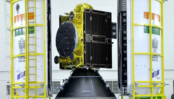
The Indian Space Research Organisation (ISRO) has encountered a significant setback with its recently launched NVS-02 navigation satellite. Launched on Jan. 28, 2025, the satellite is currently stranded in a transfer orbit due to a critical failure in its onboard propulsion system, ISRO stated in a report. The issue occurred when the valves admitting the oxidizer to fire the thrusters for orbit raising failed to open, which prevented the satellite from reaching its intended orbital position.
The NVS-02 satellite, part of India’s Navigation with Indian Constellation (NavIC) program, was launched using a Geosynchronous Satellite Launch Vehicle (GSLV) Mark II rocket from the Satish Dhawan Space Centre. The launch placed the satellite into a geostationary transfer orbit with a perigee of approximately 165 km and an apogee of approximately 37,582 km.
ISRO noted in its statement that other systems on the spacecraft were working well, including a successful deployment of its solar panels.
“The satellite systems are healthy and the satellite is currently in elliptical orbit. Alternate mission strategies for utilizing the satellite for navigation in an elliptical orbit are being worked out,” ISRO stated.
The space agency is now exploring alternative mission strategies to utilize the satellite for navigation in its current elliptical orbit. However, the low perigee of NVS-02 poses a significant risk, as it exposes the spacecraft to high atmospheric drag, potentially leading to an early reentry if the orbit cannot be raised.
NVS-02 is based on ISRO’s I-2K satellite bus, which has been used for other Indian communications and navigation satellites operating in geostationary orbit. The spacecraft had a launch mass of 2,250 kg.
The spacecraft was intended to operate at 111.75 degrees east in GEO, replacing the IRNSS-1E spacecraft there. It is the second of five satellites planned for India’s Navigation with Indian Constellation, or NavIC, program to provide positioning, navigation and timing services in India and the surrounding region. The first, NVS-01, launched in 2023 and operates in GEO.
Microchip Technology has introduced its second-generation Low-Noise Chip-Scale Atomic Clock (LN-CSAC), model SA65-LN. It features a lower profile height and operates in a wider temperature range, providing low-phase noise and atomic clock stability in challenging environments.
Chip-scale atomic clocks (CSACs) offer precise and stable timing in situations where traditional atomic clocks are impractical due to size or power constraints or where satellite-based references may be unreliable.
The SA65-LN, featuring Microchip’s Evacuated Miniature Crystal Oscillator (EMXO) technology, offers significant advancements in oscillator design. With a profile height of less than half an inch, power consumption under 295 mW, and an operating temperature range from −40°C to +80°C, this compact device delivers impressive performance. These enhanced specifications make the SA65-LN an ideal choice for a wide array of aerospace and defense applications. It is particularly well-suited for use in mobile radar systems, dismounted radios, IED jamming equipment, autonomous sensor networks, and unmanned vehicles, where size, power efficiency, and temperature resilience are crucial factors.
The LN-CSAC combines a crystal oscillator and an atomic clock in a single device, offering a low-phase noise of 10 Hz < −120 dBc/Hz, an Allan Deviation (ADEV) stability of < 1E-11 at 1-second averaging time, and an initial accuracy of ±0.5 ppb. The LN-CSAC also demonstrates frequency stability with a < 0.9 ppb/mo drift and maximum temperature-induced errors of < ±0.3ppb. These features contribute to high-quality signal integrity and atomic-level accuracy, potentially extending mission durations and reducing maintenance requirements.
“Seen & Heard” is a monthly feature of GPS World magazine, traveling the world to capture interesting and unusual news stories involving the GNSS/PNT industry.
Waymo opens autonomous rides in LA
Photo: Waymo
Waymo has launched its fully autonomous ride-hailing service in Los Angeles, available 24/7, following a waitlist of nearly 300,000 users before its rollout. The service covers nearly 80 square miles of Los Angeles County, including Santa Monica, Hollywood Boulevard and the University of Southern California. Waymo plans to expand its coverage as it scales its operations.
A large UAV show in Quanzhou, Fujian Province, China, ended in disaster when hundreds of UAVs crashed due to GNSS jamming. The event, intended to celebrate the city’s history with 2,000 UAVs equipped with low-altitude fireworks, faced significant disruptions when a camera drone entered the area without notifying authorities, leading them to mistakenly jam the signal. This incident resulted in an estimated loss of more than 10 million yuan ($1.4 million)
ISPRA project unveils coastal habitats of Italy
Photo: ISPRA
The PNRR MER A16-A18 project, led by the Italian Institute for Environmental Protection and Research (ISPRA), has released its first preliminary data for mapping Italian coastal habitats through the WebGIS Virgeo cartographic platform. The project focuses on mapping the growth of the Posidonia oceanica and Cymodocea nodosa meadows, which are crucial for biodiversity. Using high-resolution satellite imagery, lidar sensors and autonomous unmanned vehicles, the project is creating a comprehensive database for marine coastal ecosystem management and protection.
Celestial navigation system for UAVs
Photo: Cpl. Harrison Rakhshani
Researchers at the University of South Australia have developed a celestial navigation system for UAVs. The new system combines visual observations of the stars with standard autopilot technologies. In tests of the system using a fixed-wing UAV, researchers could pinpoint its position within 2.5 miles. This technology can be deployed by UAVs in GPS-compromised or denied areas by eliminating the need for GPS.
Nearly three quarters of Earth’s surface is covered by water, yet only about a quarter of that surface has been mapped in detail using modern high-resolution technology.
Marine experts worldwide work together to chart the ocean floor, ensuring the safety of ports, harbors and navigable routes. This effort is crucial for global trade, as more than 90% of goods are transported by ships. Ocean floor surveying also supports the installation of offshore infrastructure such as fiber optic cables, pipelines, drilling platforms and wind turbines.
The increasing population in coastal regions and rising sea levels due to climate change have heightened the importance of observing coastal transformations, erosion and other marine alterations. These factors are essential for understanding and protecting coastal ecosystems.
Mapping techniques
In deep waters, massive multi-beam echo sounders (MBES) operating at very low frequencies collect depth data. As water depth decreases, smaller devices with higher frequencies and resolution must be used. However, near the shore, these devices become less efficient due to the slope of the shelf interfering with sound signals.
In near-shore scenarios, collecting depth data is best done using airborne lidar sensors, which offer several advantages over sensors on surface vessels. One advantage of airborne sensors is that they can simultaneously map both the seafloor and the adjacent topography to offer seamless land-water transition data. This capability is particularly valuable in dynamic coastal environments where rapid coverage of large areas is essential.
Bathymetric lidar is specifically designed for mapping shallow coastal waters, typically effective up to depths of 50 m. It can provide high-resolution data, often achieving sub-meter positional accuracy, which is crucial for detailed coastal mapping. By combining MBES for deeper waters with lidar for near-shore areas, researchers and surveyors can create comprehensive and accurate maps of the entire coastal zone. This method offers an in-depth understanding of underwater topography, aiding various applications in marine science, coastal management and navigation.
The waters of the Cayman Islands are abundant in marine life, featuring coral reefs, seagrass beds and a variety of fish species. A high-resolution map of the seafloor is essential to begin exploring, identifying, characterizing, exploiting, conserving and managing ocean resources. Saildrone has begun a mission to map 29,300 square nautical miles (100,490 sq km) of the Cayman Islands’ Exclusive Economic Zone (EEZ). This mission uses autonomous technology to survey 80% of this EEZ.
The Cayman Islands EEZ, extending up to 200 nautical miles from shore, encompasses an area nearly half the size of Florida — and 380 times greater than the island itself. The mission will provide detailed and precise bathymetric data for this area, contributing to a comprehensive understanding of the seafloor topography in the region. The data collected seeks to enhance maritime navigation and support scientific research, environmental conservation efforts and marine resource management in the Cayman Islands.
“Our waters hold such great value to us for a myriad of reasons, ranging from recreational to economic. Conducting this assessment will allow our government to make data-driven decisions that will strengthen our policies and legislation as it relates to our maritime infrastructure,” said Juliana O’Connor-Connolly, premier and minister for District Administration and Lands.
The Saildrone Surveyor USV is a purpose-built platform for autonomous deep-water ocean mapping. (Photo: Saildrone)
The mission is philanthropically funded by the London and Amsterdam Trust Company Limited, a Cayman-based organization. Saildrone is tasked with collecting the raw bathymetry data, which will be provided to the UK Hydrographic Office to process and update the Cayman Islands’ nautical charts. The data will belong to the government of the Cayman Islands.
Autonomous seafloor exploration
The mission is being conducted using a 20-m Saildrone Surveyor uncrewed surface vehicle (USV) equipped with MBES and metocean sensors for ocean mapping and ecosystem monitoring, as well as radar, cameras and advanced machine learning. Metocean stands for meteorology and physical oceanography. Globally, only 26% of the ocean has been mapped, a result of the lack of survey ship capacity. While a survey ship takes years to build, Saildrone can produce one Surveyor in as little as six weeks.
This nautical chart shows the Cayman priority mapping areas. The yellow oval indicates the vessel’s location as of Dec. 9, 2024. (Photo: Saildrone)
Saildrone USVs have demonstrated a reduction of more than 97% in operational carbon emissions when compared to survey ships to accomplish the same task. Additionally, they lower the risk to personnel. This information is highlighted in Saildrone’s Carbon Impact Report, which provides a comprehensive evaluation of the carbon emissions associated with maritime data collection and the emissions mitigated by using Saildrone’s USVs.
Saildrone’s ocean mapping solutions support storm surge modeling efforts and emergency response, as well as coastal resiliency and hazard studies, resource management, restoration projects, habitat mapping and infrastructure for renewable energy generation. USVs equipped with deep ocean mapping sonars now serve as a reliable option for data collection in large areas such as EEZs.
Bathymetry is crucial to understanding Earth’s aquatic environments. Its importance has evolved significantly since the early days of navigation, when mariners relied on lead lines and poles to gauge water depths. The field of bathymetry continues to advance with emerging trends that enhance data collection capabilities. Autonomous platforms such as USVs and autonomous underwater vehicles are increasingly utilized for bathymetric surveys, allowing for more extensive and detailed mapping. Additionally, as the industry grapples with challenges such as workforce shortages and the need for more efficient data collection methods, autonomous systems are proving to be a valuable solution.
Trimble’s Applanix POSPac MMS, an advanced GNSS-inertial post-processing software, seamlessly integrates with the Applanix POS MV and multibeam or sonar sensors to deliver high-accuracy results. (Photo: Trimble)
“Autonomous and uncrewed platforms have become a real force multiplier, and the trend continues,” said Peter Stewart, director of marine products at Trimble Applanix. “Companies such as XOcean and Saildrone are showing what is possible, leveraging cloud processing and enabling data collection in remote areas while maintaining a work-life balance for their staff. Since finding qualified engineers and surveyors to fill these roles offshore is an industry-wide concern, more flexible working conditions are needed to hire and retain talent.”
Another emerging trend is the development of sensors capable of penetrating murky waters, which can significantly enhance surveyors’ ability to gather data in challenging environments. Advanced sonar systems, innovative light-and-sound combinations and newly developed sensors allow research teams to collect detailed data. Post-processing technology for bathymetry has also significantly advanced, making data acquisition, processing and presentation more efficient and accessible. This allows researchers to map and study underwater terrains that were previously inaccessible or poorly understood.
Typical marine vessel data processed in POSPac MMS PP-RTX mode. (Photo: Trimble)
“Ease of use and installation are key trends toward ensuring valuable hydrographic data can be acquired, processed and presented efficiently,” Stewart said. Trimble works with users and third parties to offer an optimal workflow, making technology and the data it creates more accessible and operations more efficient, he added.
The IN-Fusion+ PP-RTX2 processing mode in Trimble’s POSPac MMS software is designed to improve post-processed GNSS-inertial trajectory generation. This mode uses Trimble’s CenterPoint RTX technology to deliver centimeter-level positioning accuracy without the need for local base stations. Stewart shared how this technology can be particularly useful when surveying around offshore windfarms, where shore-based RTK infrastructure is often too distant to be useable.
The Directorate of Defense Trade Controls (DDTC) has changed the regulatory status of Controlled Reception Pattern Antennas (CRPAs) for position, navigation and timing (PNT). Starting September 2025, CRPAs will no longer be subject to the International Traffic in Arms Regulations (ITAR). Instead, they will be reclassified under the less restrictive Export Administration Regulations (EAR) list, which is under the jurisdiction of the Department of Commerce.
The rule, in part, removes items from the U.S. Munitions List (USML) “that no longer warrant inclusion.” According to the rule, “certain anti-jam antennas no longer provide a critical military advantage, with increasing commercial utilization applicable to civil GPS resiliency.” By removing CRPAs for PNT, “the Department intends to facilitate civil global navigation system resiliency.”
The recent regulatory change is expected to significantly impact several industries, including airlines, autonomous vehicles, UAVs and critical infrastructure applications, which can benefit from the increased availability of CRPAs. Additionally, this change may open the U.S. market for CRPA manufacturing, potentially resulting in swift technological advancements and lower costs.
The importance of CRPAs lies in their ability to protect GNSS receivers from interference and jamming. GNSS signals are inherently weak and susceptible to both deliberate and unintentional interference. CRPAs work by adjusting their reception pattern to create nulls in the direction of interfering signals while maintaining reception from desired satellite signals. This adaptive beam steering capability allows CRPAs to effectively eliminate signals from particular directions while preserving signals from others, making them a powerful tool in ensuring the reliability of GNSS-dependent systems.
Topcon Positioning Systems has expanded its Topnet Live reference station network by adding 200 new geodetic stations across the United States. This expansion enhances the availability of centimeter-level accuracy for industries requiring precise positioning, such as engineering, surveying, construction and agriculture.
The upgraded network provides advanced network corrections that optimize operational workflows in various sectors. The enhanced infrastructure supports emerging technologies such as automated turf management, precision line marking, imaging systems and UAV operations for mapping and delivery.
This expansion builds upon previous efforts throughout 2024, resulting in a 30% increase in Topnet Live’s total coverage in the United States. The network now offers comprehensive, network-modeled solutions that cater to a wide range of professional requirements across multiple market segments.
The Topnet Live network utilizes Networked Transport of RTCM via Internet Protocol (NTRIP) to stream GNSS corrections data via the Internet for RTK positioning. This technology allows for centimeter-level accuracy by mitigating errors from factors such as ionospheric disturbances, satellite clock deviations and orbit inaccuracies.
The U.S. Space Force transferred Satellite Control Authority of the GPS III Space Vehicle 07 (SV-07) to the 2nd Navigation Warfare Squadron, Mission Delta 31, at Schriever Space Force Base, Colorado. The satellite became operational and available to global users on Jan. 22, 2025 — expanding the GPS constellation to 31 active vehicles. The transfer is the first instance in which the Satellite Control Authority moved from the acquisition program to the operations squadron within a single Delta, reflecting the new mission delta structure.
The space vehicle was launched on Dec. 16, 2024, from Cape Canaveral Space Force Station, Florida, aboard a SpaceX Falcon 9 rocket as part of a Rapid Response Trailblazer mission. The operation involved retrieving an existing GPS III satellite from storage, expediting integration and launch vehicle preparation, and swiftly processing the satellite for launch.
The entire process, from initiation to launch, was completed in approximately three months, significantly shorter than the typical six-month pre-launch processing timeline. This accelerated timeline was achieved through collaboration between multiple Space Force organizations and partner agencies.
The GPS III SV-07 satellite is equipped with M-code, designed to improve anti-jamming and anti-spoofing capabilities, enhancing secure access to military GPS signals. This launch contributes to the ongoing modernization of the GPS constellation following the launch of GPS III SV06 in 2023. Mission Delta 31, activated on Oct. 15, 2024, is responsible for providing, operating, and sustaining high-integrity positioning, navigation and timing (PNT) capabilities. It comprises three squadrons and one detachment, including the 2nd Navigation Warfare Squadron, which operates the GPS satellite constellation.
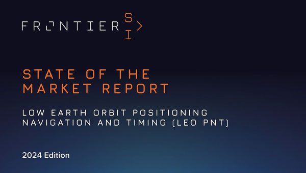
PNT services are integral to industries worldwide, from logistics and telecommunications to critical infrastructure. The rise of LEO satellites is set to revolutionize this space, overcoming limitations of traditional GNSS, such as vulnerability to interference and limited urban coverage, according to FrontierSI.
Key insights from the report, which is the first in a series of annual reports, include:
Industry impacts: How LEO PNT addresses GNSS vulnerabilities, offering more robust and accurate navigation solutions.
Government and regulatory challenges: The rise of commercial PNT players necessitates collaboration to address interoperability, spectrum management and governance issues.
Business innovation opportunities: Critical sectors such as logistics and autonomous systems stand to benefit from assured and precise PNT services.
Investment potential: The nascent stage of the LEO PNT market presents opportunities for investors to identify game-changing technologies and key players.
The report is recommended for professionals and organizations deeply engaged in satellite navigation, including:
Engineers, designers and project managers in the space and defense industries
Autonomous systems manufacturers
Policymakers and regulatory bodies responsible for satellite navigation and spectrum management
Commercial stakeholders in telecommunications, transport and logistics
Academics, researchers and analysts with an interest in satellite navigation technologies
Investors analyzing the growth potential of LEO PNT solutions
Providers of critical infrastructure reliant on precise timing synchronization
The LEO PNT State of the Market Report aims to provide stakeholders with the necessary insights to navigate this transformative period for PNT.
Eos Positioning Systems (Eos) has become a member of the Municipal Information Systems Association (MISA) Canada’s National Partner Program (NPP). This collaboration aims to enhance the capabilities of Canadian municipalities in utilizing GNSS technology for improved mapping and asset management.
The partnership between Eos and MISA Canada facilitates the digital transformation of Canadian cities and towns by bringing together municipal leaders and technology innovators. Eos specializes in providing high-accuracy GNSS technology to local governments, enabling them to maintain critical infrastructure and public services more effectively.
Eos manufactures GNSS receivers in Canada that offer submeter to centimeter-level accuracy for GIS and mapping applications. These tools are particularly useful for utility and infrastructure mapping, public works asset management, environmental monitoring and planning and emergency response coordination.
The GNSS receivers from Eos are designed to integrate with existing GIS software and mobile devices, allowing field teams to efficiently collect, update, and manage spatial data with high precision. As part of MISA’s NPP, Eos will provide members with access to specialized solutions, training resources, and ongoing technical support to maximize the benefits of GNSS technology in municipal operations.
ANELLO Photonics has received a Phase I Small Business Innovation Research (SBIR) contract from the U.S. Navy. The six-month contract will allow ANELLO to demonstrate its optical gyroscope and sensor fusion technologies for navigation without relying on GPS.
Under the contract, the U.S. Navy will evaluate ANELLO’s integrated photonics technology and AI-based sensor fusion engine. These technologies aim to maintain accurate navigation in challenging environments where GPS signals may be unavailable or compromised.
ANELLO Photonics’ technology can be used for construction, agriculture, transportation, robotics, unmanned vehicles and national security. The company’s focus on navigation solutions for GPS-challenged scenarios aligns with growing needs in both military and civilian domains for reliable positioning systems in diverse environments.
Saying the government must focus on “delivering an operational resilient positioning, navigation and timing (PNT) system for the United Kingdom as soon as we can,” the British Science Minister, Lord Patrick Vallance, announced several initiatives in his opening remarks to the Royal Institute of Navigation’s UK PNT Leadership Seminar on Nov. 20, 2024.
Among them was a funding increase for the National Physical Laboratory’s National Time Centre (NTC) project from £30 million ($38 million) to £62.7 million ($79 million) and a plan to have NTC and the first of the nation’s new eLoran towers at initial operating capability (IOC) by January of 2027.
Plans for all efforts beyond next year were necessarily “subject to spending review.”
Still, seminar attendees were gratified to hear the minister’s endorsement of the 10-point PNT policy framework published by the previous administration in 2023 and his commitment to operationalizing it with implemented systems.
Shabana Haque, Ph.D., head of the United Kingdom’s National PNT Office, also addressed the seminar and elaborated on the government’s actions to date and plans moving forward. She also discussed efforts toward developing quantum technologies and how all the capabilities would be incorporated into a coherent architecture.
Photo: RNT Foundation
Clocks
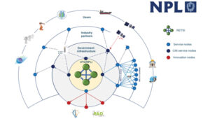
The United Kingdom recognizes time and timing as the most fundamental component of the PNT utility. Its NTC R&D program, run by the National Physical Laboratory (NPL), has been up and running since 2019. Its primary objective is to create “…a resilient UK national time infrastructure through the building and linking of a new atomic clock network distributed geographically in secure locations.”
Five years later, that program is coming to an end. Plans are in the works for the next phase of the NTC program, which includes developing a national timing infrastructure and supporting a new timing ecosystem — one that includes two-way satellite-time transfer (TWSTT), eLoran and the country’s legacy MSF radio time service. The industry will have a valuable role in the architecture of time distribution and providing value-added services while accessing highly resilient and well-authenticated core government time infrastructure.
As a result of NTC work to date, traceable time and frequency signals can now be accessed by industry and academia from three NPL nodes dispersed across the United Kingdom. They are at the University of Strathclyde in Scotland, the University of Cranfield in the Midlands and the University of Surrey in the south.
eLoran
eLoran also features prominently in the United Kingdom’s PNT plans. Britain operated Loran-C as part of the Northern European network until the end of 2015. For the last year of that, differential stations were deployed along the United Kingdom’s eastern coast and maritime operations based on eLoran were authorized.
On Jan. 1, 2015, and despite British pleas to the contrary, other northern European nations terminated Loran broadcasts in favor of Galileo. The United Kingdom has continued to operate its single eLoran transmitter as a national time signal. Plans call for additional transmitters to enable eLoran navigation across the nation and its adjacent waters within the next two years.
UrsaNav Loran monitor on Nautel equipment. (Photo: RNT Foundation)
The UK government has been working with several partners to advance its understanding and plan for the implementation of an eLoran capability. Haque highlighted work with the European Space Agency’s NAVISP program, resulting in the British company Roke developing an eLoran antenna for handheld devices.
She also discussed integrating the NTC’s clock and fiber network with eLoran signals and developing GNSS/eLoran receivers.
Many were particularly interested in an “eLoran Effectiveness Report” that the government commissioned and received from the General Lighthouse Authority’s Research and Development (GRAD) team. GRAD has extensive experience with the technology, having operated and evaluated the differential eLoran system along Great Britain’s east coast.
In a related move that helped signal the United Kingdom’s commitment to the technology, the Ministry of Defence issued a Request for Information (RFI) in September 2024 about a deployable eLoran capability. The RFI indicated that the document was a prelude to an acquisition.
Quantum research
The United Kingdom has invested more than £1 billion ($1.3 billion) into quantum research, which has the potential to contribute to PNT with better timekeeping and inertial and gravimetric sensing.
One aim of the quantum research program is to develop “…new navigation and timing systems to provide resilience and improved accuracy in the event of the denial of satellite systems.” A specific goal is to deploy quantum navigation systems, including clocks, on aircraft by 2030.
The program began in 2014 and has seen a significant increase in 2024 with the establishment of five quantum hubs nationwide. The hub at the University of Glasgow focuses on resilient PNT systems for national security and critical national infrastructure.
Policy and coordination
Minister Vallance and Haque also discussed two important non-technology themes.
The first was that the United Kingdom’s PNT office is fully funded, staffed, and very active. It was created last year as a cross-government effort and includes representation from the Ministry of Defence. In addition to pushing the nation’s PNT efforts forward, the office has been engaged with numerous other governments, including those of the United States, Canada, Australia, New Zealand, Europe, Japan and Korea.
USCG Loran tower circa 1995. (Photo: RNT Foundation)
Second, while the PNT initiatives are necessary for the nation’s resilience and security they will also be a source of economic benefits. This goes beyond enabling the British economy to function during local and potentially widespread GNSS disruption events. As the nation develops the technology stack to support its own resilient PNT architecture, along with enabling and supporting policies, resilient PNT devices and services will become marketable to others.
A sovereign PNT capability that can both stand on its own and cooperate with GNSS is becoming increasingly attractive to many nations. Being able to source such a capability from a respected and trusted ally such as Great Britain could make acquiring and implementing such a system much easier for many.
The UK Science Minister also praised the RIN’s work and publication of a series of tools to help explain PNT and the need for resilience to those outside the community. The tools also will help organizations evaluate their readiness for GNSS disruptions.
Available from the RIN’s Resilient PNT Portal, they are
A PNT explainer that outlines risks from over-dependence on GNSS and provides links to other informative resources.
A best practices “placemat” describing a “Prepare, Act, Recover” framework for PNT disruptions.
A PNT resilience checklist for organizations to use to self-evaluate their risk from GNSS disruptions.
The RIN recommends PNT experts use these tools working with customers, suppliers, and partners and act as a “guiding hand.”
The RIN sees these all as a “phase 1 release.” Feedback on the tools is encouraged and should be sent to [email protected]. The RIN team is eager to know what works and what could be improved, as well as to receive suggestions for other efforts.
As a “learned society,” the RIN has a significant influence on government policy and direction. This was recognized by Lord Vallance, saying, “The Royal Institute has played a really important role in recent years to highlight the PNT opportunity and risk, to provide expertise, and to work with government on solutions.”
The RIN’s director, John Pottle, and RIN Fellows Ramsey Faragher, Guy Buesnel and Andy Proctor were all recognized during the seminar for their contributions to the organization’s resilient PNT efforts.
UK leading the west
While China is in the final stages of establishing a nationwide clock system integrated with eLoran and signals from space, and South Korea is following suit, the United Kingdom seems to be the only Western nation in the process of establishing a coherent and resilient national PNT systems-of-systems architecture.
Some nations have substantial fiber timing networks, Europe seems to be on the path to a timing backbone, and the United States has three eLoran transmitters on air. However, none have announced the type of integrated plans the UK has published.
When asked about this, one UK PNT technology and policy expert opined that his nation is so far ahead of Europe and the United States because “we are unencumbered by having our own GNSS.”
His idea is that GNSS involves a lot of time, effort and money. The kind of financial and emotional commitments needed for these huge projects makes it hard for many to come to grips with the limitations and vulnerabilities of GNSS and the need to implement complementary systems. Both government officials and GNSS industry lobbyists may tend to resist such efforts, he said.
Concerning the UK government’s investment in OneNav, he said it is still possible that the United Kingdom might also pursue a space-based capability. Rather than establishing the capability on its own, in his opinion, the government will be much more likely to look for a commercial subscription service.
“We will access GNSS when we can trust it, and may pay for other signals from space,” he said. “But we want a sovereign capability for the United Kingdom, and the future of resilient PNT is terrestrial.”