The U.S. Army has released a Request for White Papers (RfWP) to develop new C5ISR modular open Suite of standards (CMOSS) mounted form factor (CMFF) prototypes.
Through CMFF, the Army aims to easily and rapidly equip ground vehicles and aviation platforms with positioning, navigation and timing (PNT) and electronic warfare (EW), through capability cards plugged into a common chassis.
The chassis, which offers power, networks and radio frequency, allows Soldiers to “plug and play” capabilities right into the vehicle without the need to custom install and upgrade individual communication and computing systems.
In this prototype effort, the key needs are to develop, procure and furnish the Army with the CMFF chassis, also known as Mounted Common Infrastructure (MCI), plus the smart display for user interface, hardware development, software development and Plug-In Cards with the following capabilities:
Converging tactical communication waveforms.
Mission Command applications.
Assured Positioning, Navigation, and Timing (APNT.)
Force Protection capabilities.
The Army plans to award a contract using the Other Transaction Authority (OTA) with system of system and prototype integrators to provide the complete CMFF system offerings. Industry partners who respond to the RfWP will have an opportunity to showcase the fully functional CMFF system at a technology demonstration in late summer 2024.
“The power of the true concept is when you can take a chassis and put it in another vehicle and you can mix and match cards,” said Col. Shermoan Daiyaan, project manager for Mission Command. “That’s when you’re following a standard. You’re matching a standard, and it just works.”
In October 2023, the United Kingdom’s government announced a 10-point “policy framework” to greatly increase the nation’s resilience to disruption of vital positioning, navigation and timing (PNT) services.
Two months later, Vladimir Putin began regularly jamming and spoofing GPS for aircraft and ships across a broad swath of the Baltic and northern Europe. It was the world’s first instance of such extensive activity in the absence of armed combat.
Properly executed, Britain’s policy framework will position it as a global leader in sovereign and resilient PNT. It will also provide ample new business opportunities for British businesses to fill this growing need.
The product of years of effort under both Coalition and Conservative governments, the PNT policy framework addresses challenges that have been extensively documented and studied.
The nation’s over-reliance on space- based PNT has long been recognized. Its National Risk Register listed solar activity as a threat to PNT in 2012. When, despite extensive lobbying by the UK, the rest of Europe shut down its Loran transmitters in 2015 to prevent competition with Galileo, Britain kept its single transmitter on air as a national precise time reference. In 2018 a “Blackett Report” documented the nation’s over-dependence, estimated the consequences of service outages and made a series of recommendations. A 2021 economic report further estimated the scale of the problem.
All this well before Russia’s demonstrations of the fragility of GNSS with its attacks on Ukraine and recent aggression in the Baltic.
Yet action on Britain’s way forward was repeatedly deferred.
The sticking point seems to have been deciding upon the mechanics of how the government would deal with the invisible PNT utility, which is a capability essential to every government department and every sector of the economy and society. Should it be in the Department for Transport? Perhaps in Business and Trade or Defence? Some suggested the Cabinet Office should lead addressing the PNT challenge.
The final decision was a cross- government office hosted by the Department for Science, Innovation and Technology. The office includes members from the Ministry of Defence and is tasked with leading and coordinating a whole-of-government approach.
Moving Forward
It is easy to be skeptical about the success of this new enterprise. Regardless of the nation, government policy frameworks, strategies and the like often can be a way for politicians and bureaucrats to create the impression of action without having to ever really do anything. Documents are often published and then go on a shelf, never to be seen again.
That does not seem to be the case here, though.
The very first action item in the PNT policy framework is to “[e]stablish a National PNT Office …to improve resilience and drive growth with responsibility for PNT policy, coordination, and delivery.”
While several of the 10 items begin with “develop a proposal for…,” the projects are both considered and specific, such as a timing system “of last resort” for the Ministry of Defence and the expansion of eLoran.
Britain’s integrated governance and system-of-systems approach to PNT can make the nation virtually immune to the kinds of disruptions and infrastructure challenges being seen in the Baltic and conflict zones around the world.
Achieving that goal will involve the development of new user equipment, systems to prioritize and integrate different PNT sources, new interfaces for various infrastructures, improvements to existing technologies (e.g., an encrypted component for eLoran to make it even more secure and reliable), and new policies for responsible PNT use in critical applications.
When complete, the UK will have the sovereign and resilient PNT it needs to support national, homeland and economic security.
Global Leadership and Profit
Yet Great Britain is not the only nation over-dependent on fragile PNT signals from space provided by others. Most of the world is in the same situation.
By actively promoting and sharing its developing expertise and tech stack, the UK will become a global thought leader and technology provider for sovereign and resilient PNT. A capability that will be in greater and greater demand as malicious actors, both large and small, continue to exploit the weaknesses of satellite-based navigation and timing.
Yet, to realize these benefits, the UK must act swiftly and seize the moment.
At present there is a leadership vacuum in this field. While China has its own extremely robust and integrated PNT system based on a combination of clocks, fiber, terrestrial broadcast eLoran, and space, it does not seem eager to export that to others. China may prefer to woo nations into dependence on its BeiDou satellite PNT system, rather than enabling others’ sovereignty.
Additionally, while entrepreneurial South Korea has implemented its own space-based, eLoran and fiber PNT, it is unclear how integrated the various sources are. We have also seen no evidence that they have plans to share, or sell, their success to others.
As disruptions to GPS and other GNSS continue to increase around the globe, so, too, do calls for and moves toward solutions that include alternatives.
Last year the European Union issued a tender for an integrated GNSS/eLoran receiver. Türkiye has implemented its own local terrestrial PNT systems in several port and urban areas. India envisions expanding its regional navigation satellite system to cover the globe.
Britain has the plans, capability, and resources to become the world leader in this essential and growing technology sector — and the government is working with the Royal Institute of Navigation and other learned bodies to make it a reality.
Yet its window of opportunity may already be closing.
Rather than regarding its PNT policy framework as a routine item of work, we hope the UK government seizes this opportunity for international leadership and reaps all the inherent diplomatic, security and economic benefits.
Swift Navigation and Bad Elf have partnered to deliver a complete, turnkey solution for high-volume and high-precision GIS data collection. GIS data allows workers across industries to create precise digital maps to improve worker safety and efficiency in construction, utilities and environmental management.
By combining BadElf’s GNSS receivers with Swift’s precise positioning solutions, field teams can capture centimeter-accurate location data on a tablet or smartphone Field teams can now more quickly and safely perform maintenance, dig trenches and avoid hazards such as high-voltage wires. wires.
Swift’s Skylark Precise Positioning Service is a cloud-based GNSS corrections service that enables accurate and reliable positioning for location-based products worldwide. Skylark is offered in multiple variants for multiple use cases, each with varying requirements for accuracy, coverage, power consumption and cost.
Bad Elf is a provider of GNSS receivers built for modern GIS mapping applications. Bad Elf’s line of Flex and Flex Mini receivers stream location data to any Bluetooth-equipped device, including Apple, Android, and Windows. When paired with Skylark, Bad Elf receivers deliver accuracy down to one centimeter and a fix within seconds. The combined solution is ideal for field workers requiring reliable high-accuracy positioning.
Trimble and Esri have extended their partnership to enhance collaboration in geographic information system (GIS) software, location intelligence and mapping. This ongoing effort aims to improve processes, support decision-making, and automate workflows for greener infrastructure planning, construction and operations for users.
The companies are exploring emerging technologies, particularly in industry data models that support accurate generative AI technologies and workflows. Trimble’s geospatial field systems, which collect location intelligence and 3D datasets, are enhancing workflow support in Esri ArcGIS Indoors and the ArcGIS Utility Network.
Trimble Unity — a new asset lifecycle management suite — leverages Esri’s GIS into construction project and capital planning, enterprise asset management and permitting solutions to improve how universities, healthcare facility operators, utilities and federal, state and local government jurisdictions track the asset management lifecycle.
Trimble and Esri also partnered with The HALO Trust, the world’s largest landmine-clearing non-profit organization, which combined Trimble’s high-accuracy mapping technology with Esri’s ArcGIS software to improve the capacity to locate and remove landmines and other explosive hazards, making communities safer.
Inertial Labs has integrated its RESEPI lidar solution into ideaForge UAVs. The integration seeks to improve lidar mapping capabilities and is suitable for mining, forestry, geographic information system (GIS) and land surveys, water resources management and more.
The UAVs equipped with RESEPI offer a vertical accuracy of 2 to 3 cm. The precision is maintained at 2 to 4 cm and it excels at a flight height of 50-100 m. The integration enhances the capabilities of ideaForge UAVs, offering users accurate and reliable data for mapping and surveying applications.
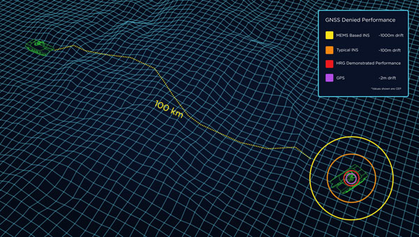
When a vehicle passes through a GNSS-denied area, its navigation system might be thrown off and report an incorrect position. Conversely, INS is inherently subject to drift — the steady accumulation of errors — and therefore must be periodically re-initialized by an external source, such as GNSS. (Photo: Safran Federal Systems)
The term “original equipment manufacturer”(OEM) is widely used, yet vaguely described. In general, an OEM product is one that a company creates and sells to be integrated into systems made by other manufacturers.
In the GNSS industry, the purchasers of OEM products typically are manufacturers of products that require precise positioning or navigation capabilities, from precision agriculture, to surveying and mapping, to UAV missions. Often, manufacturers integrate the OEM GNSS receivers with other sensors, such as inertial measurement units (IMUs) and lidar devices.
A large portion of the OEM business goes unnoticed by the end users of the equipment that utilizes OEM components. These components, such as a guidance system, are often hidden from view, due to being housed under a hood or elsewhere deep within the system.
In the following case studies, OEM products complement GNSS in air, land and marine applications. Safran Federal Systems’ INS for land vehicle navigation and Septentrio’s AIM+ anti-jamming and anti-spoofing technology tackle land and air-based defense applications, while an OxTS IMU is used in a coral reef restoration project to accurately record ship motion.
Land vehicle navigation in GNSS-denied environments
Safran Federal Systems
Ground vehicles in defense operations often navigate in challenging environments where traditional GPS signals are contested or unreliable. This includes dense urban areas, heavily forested regions, or any areas where enemies employ electronic warfare to disrupt GPS signals. Having a robust navigation system that can provide both the vehicle’s location in real time as well as its precise orientation and direction/heading is crucial for defense applications. An inertial navigation system (INS) can provide reliable position and heading data for short periods of time or distances without the aid of GPS satellite signals, allowing vehicles to stay on course and maintain awareness of their location.
Precise location and navigation capabilities are essential for mission planning, execution and coordination with other units. Inaccurate navigation can lead to mission failure, unintended engagements, or even friendly fire incidents.
Geonyx INS
Safran’s Solution
Geonyx INS with incorporated M-Code capability
Safran has developed the Geonyx INS, which provides route guidance in GNSS-denied environments. It incorporates hemispherical resonator gyroscope (HRG) technology and does not rely on external satellite signals for navigation and heading. Instead, it uses gyroscopes to detect changes in heading and accelerometers to detect changes in acceleration, then uses those data to calculate the vehicle’s position, orientation and velocity.
The Geonyx will output coordinates of the vehicle’s current location as well as the data on its intended position to the vehicle’s battle management system (BMS). It can maintain an accuracy of a couple of meters after tens of miles of pure inertial navigation.
Geonyx is a combat-proven INS solution for ground vehicles, augmenting battle management systems. It can achieve a heading accuracy as good as 0.5 mils thanks to Safran’s HRG Crystal technology. It has quick and flexible alignment, even in GNSS-denied environments.
Safran is upgrading the Geonyx to incorporate M-Code capability. This enhancement offers a fully integrated solution to tackle the challenges of GPS-denied or spoofing environments, ensuring robust and reliable navigation even in the most demanding conditions.
JammerTest in Bleik, Andøya, Norway. (Photo: David Jensen)
Resilient GNSS receiver
Septentrio
Around the world, there is an increasing demand for better resilience in positioning, navigation, and timing (PNT) systems. U.S. President Joe Biden has signed an executive order to enhance national resilience through PNT services. Geo-political tensions require a higher level of security for operations in areas of navigational warfare (NAVWAR) under contested GNSS conditions.
In countries such as Finland, companies are seeking reliable receivers that can be connected in a network to identify sources of malicious interference. In numerous GNSS applications, such as reference networks, UAV surveillance, delivery and timing synchronization, the repercussions of PNT degradation or loss can be significant.
Septentrio’s Solution
Septentrio took part in the JammerTest 2023 event organized by the Norwegian government on the remote island of Andøya, where live interference testing was conducted in a controlled environment.
While most of these test events are classified and their results cannot be shared publicly, the JammerTest represents one of the first public events of its kind where the sharing of results is encouraged.
After five days of intensive testing in Norway, Septentrio’s AIM+ anti-jamming and anti-spoofing technology proved to work well under live interference conditions. Test results revealed that under real interference, receiver technology plays a key role, while antenna technology plays a supporting role. By testing the receiver under various types of spoofing attacks, it was shown that the best spoofing protection lies in having multiple anti-spoofing mechanisms working together.
Detecting and Mitigating GNSS Jamming
This test used a “cigarette lighter” jammer, which is commonly available for purchase online. It emits signals with power between 10 dBm and 15 dBm and can disrupt GPS L1 and L2 signals. Other jamming tests involved using jammers with signals 10 million times more powerful than GNSS signals.
Over one day of intensive jamming tests, receivers with integrated AIM+ demonstrated 99.5% positioning availability under various forms of jamming from simple continuous narrow-band interference to the most complex wide-band transmissions.
The Magic is in the Receiver
For mission-critical applications, an anti-jam antenna can help achieve maximum resilience against RF interference. During the JammerTest, three receivers were tested under heavy multi-frequency wideband jamming in combination with antennas of varying sophistication. A receiver with a standard wideband helical antenna that did not have AIM+ anti-jamming technology immediately lost tracking of satellite signals during jamming. A receiver with the same antenna, but with AIM+, continued to track signals and deliver positioning. A receiver with AIM+ coupled with an anti-jam antenna displayed that the drop in signal quality is slightly less than with a standard antenna and the receiver continued to track signals and to deliver positioning.
Tests with various anti-jam antennas showed an interference reduction of about 10 dB. While AIM+ plays a role in positioning availability under jamming, an antenna plays a supporting role and can improve the chances of getting positioning in cases where the jamming is still slightly stronger than the ability of the receiver to mitigate it. While anti-jam antennas can be effective in countering wide-band “white-noise” jamming, they are less effective for other types of jamming.
Accurate and available PNT is key to successful industrial or critical operations in challenging environments. By regularly participating in live events such as the JammerTest, Septentrio anti-jamming and anti-spoofing technology is continuously being tested and improved to withstand the latest interference attacks. This technology also has been confirmed to be effective by users out in the field, who are using Septentrio receivers in places of malicious interference, such as near contested borders.
The Reef Restoration and Adaptation Program (RRAP) is an effort to help a significant ecosystem such as the Great Barrier Reef (GBR) survive climate change. Through its Cooling and Shading sub-program, RRAP’s goal is to determine whether localized cloud brightening — a technique that involves spraying droplets of sea salt into clouds to reflect sunlight and cool Earth — and/or fogging could be a temporary solution to alleviate stress on parts of the GBR during hot summer conditions, which might lead to bleaching.
The Ordnance Survey team was tasked with consistently creating precisely georeferenced point clouds that could be utilized for identifying and classifying features. The GBR is a significant source of biogenic volatile organic compounds (BVOCs), which are likely to be impacted by ocean warming in potential climate change scenarios. In turn, these BVOC emissions can influence Earth’s radiation budget by contributing to the creation of secondary organic aerosols and cloud condensation nuclei, ultimately leading to cooling.
Southern Cross University, an RRAP partner, sought an accurate method to record ship motion for this project. The team needed to measure various parameters such as velocity, acceleration, pitch/roll, angle rate, and ship heading. They approached Industrial Measurement Solutions (IMS) and OxTS to assist them in addressing this challenge. To achieve this accurately, they needed to integrate the measurements from their existing sonic anemometer, which records three-dimensional wind velocity, with the measurements from an IMU.
OxTS Takes the Challenge
Correcting wind speed for platform motion requires two high-resolution sensors to record data simultaneously: a sonic anemometer that records three-dimensional wind velocity, and an IMU that records the movement of the platform/ship. The sonic anemometer and the IMU are two very sensitive sensors, and many of the technology challenges the team faced involved setting them up correctly and getting them to work seamlessly together.
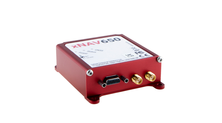
Once the project team realized that they needed an IMU to measure the ship/platform motion, one of their collaborators at the time, Airborne Research Australia (ARA), suggested an OxTS xNAV650.
After they had defined the project requirements, Southern Cross University contacted IMS who helped them navigate the commercial process.
xNAV650 is a miniature INS that uses survey-grade dual-frequency GNSS receivers and custom MEMS IMU for centimeter-level position accuracy, precise orientation and true heading. It logs the navigation data on internal storage for downloading and viewing post-mission. It can be used in many applications, such as corridor mapping and precision agriculture.
The xNAV650’s IMU allowed Southern Cross University to accurately measure the motion of the ship. The IMU was configured to “displace output” to the location of the 3D wind measurement instrument — the sonic anemometer. This allowed the project team to record the movement of the instrument directly, thus avoiding any additional complicated processing steps. Additionally, the IMU was configured to output a 1 pulse per second (PPS) signal via serial connection. This allowed the project team to connect the IMU to the sonic anemometer’s data logger to sync the time between the two instruments. This was vital on such a rapidly moving platform.
Once installed, the xNAV650 device was able to measure ship motion accurately and at high time resolution
(100 Hz), which was complementary to the team’s wind velocity and BVOC measurements. The PPS output option allowed for simultaneous measurement/recording, which would have otherwise needed to be corrected in post-calibration and would likely not have been as accurate.
“We managed to accurately record ship motion for the entire length of our second voyage,” said Liz Deschaseaux, RRAP’s research fellow on BVOC emissions. “The reliability and accuracy of the xNAV650 has had a real impact on our ability to collect meaningful data.”
Felt has introduced Felt 3.0, which includes new features and native database integrations to improve Geographic Information Systems (GIS) capabilities. The goal of Felt 3.0 is to make data more accessible and actionable for stakeholders. It provides modern GIS tools for teams to visualize, analyze and present important insights and map data relevant to their operations.
The company released version 2.0 in November 2023, which introduced UI and spatial analysis tools. This was the first step towards allowing users to gather insights from geospatial data for recruiting, analytics, management and more. Now, with Felt 3.0, teams can connect their database directly to Felt and build interactive components and dashboards tailored to their specific workflow.
Felt 3.0 allows users to directly connect Postgres/PostGIS and Snowflake databases and keep the data fresh with automated live data updates. Support for other third-party data sources, including Databricks, Amazon’s S3 and Redshift, Google’s BigQuery, and SpatioTemporal Asset Catalogs (STAC), will be available soon.
Developers can also use Felt’s new API to reduce engineering time for custom geospatial app implementations. The API allows users to create and style elements and listen to map updates via webhooks, while providing a Python SDK for professionals to continue to work in their preferred tools.
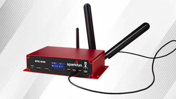
SparkFun Electronics has introduced its real-time kinematics (RTK) evaluation kit (EVK). It serves as a development platform for fixed or mobile high-precision positioning and navigation needs. The RTK EVK comes with a range of options for prototyping, including L1+L2 RTK GNSS, with L-Band correction built-in if needed, running on an agile processor.
It features custom open-source software pre-loaded with RTK Everywhere firmware. Users can configure the EVK as an RTK Base and push corrections to an NTRIP Caster or configure the EVK as an RTK Rover and use corrections delivered through WiFi or Bluetooth.
The kit uses the dual-band (L1+L2) ZED-F9P GNSS receiver from u-blox. The integrated u-blox NEO-D9S offers L-Band reception and access to correction services such as PointPerfect. The u-blox LARA-R6001D provides global cellular connectivity.
Zero-Touch RTK offers users a simple way to receive corrections. Users can register the device, plug it into Ethernet (PoE supported) or give it WiFi credentials for a hot spot and enable PointPerfect – no NTRIP credentials are required.
The RTK EVK can be easily installed in a weatherproof enclosure with its custom extruded aluminum case with machined end panels and slotted flanges.
The European Defense Fund (EDF) and the Ministries of Defense of Estonia and Finland have awarded a $6 million investment to Project BadB, a consortium led by KrattWorks, an Estonian defense technology company. The project focuses on developing advanced navigation solutions for land and aerial vehicles that operate independently of GNSS.
Project BadB aims to address the challenges posed by rapidly evolving electronic warfare technologies, such as radio jamming and GNSS spoofing. The project seeks to ensure reliable navigation for unmanned systems operating in contested environments, enhancing their operational effectiveness in active war zones and other critical areas.
Specific objectives of the project include the development of weather-independent up-to-date satellite imagery maps for unmanned aerial and ground vehicles, a machine vision module, an image recognition system and a path planning system, based on sensor data, cross-platform data sharing and swarming.
GIM Robotics will develop GNSS-denied navigation software for land vehicles, designed to resist and detect jamming and spoofing so vehicles can navigate accurately — even when GNSS signals are unavailable. The company’s technology allows land vehicles to maintain precise navigation using alternative data sources, such as satellite imagery and sensor integration.
According to EDF, the project has gained attention among European defense and innovation leaders, who see it as solving a burning issue for the rapidly growing unmanned systems sector. The situation on the technology front has changed significantly in the past two years, as the sector faces new obstacles and opportunities each day.
“We are witnessing an unprecedented fundamental change in the character of war, and our window of opportunity to ensure that we maintain an enduring competitive advantage is closing,” said General (ret) Mark Milley.
GNSS-free navigation and geolocation also possess potential for civic use – such as in applications for critical infrastructure management, natural disaster mitigation and autonomous transportation systems.
Project BadB was selected during the EDF 2023 Calls for Proposals, with a project duration of 24 months. The EDF aims to boost cooperation between companies and research entities to enhance European defense capabilities.
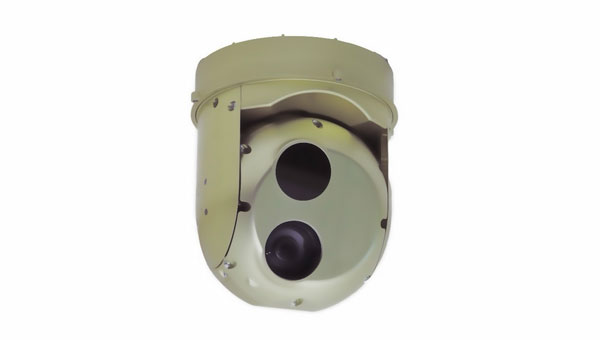
UAVOS has launched Gimbal 155, a gimbaled camera designed for the UAV Survey Mission program. The GOS-155 meets UAV requirements for surveillance and rescue missions. Its optimized size, weight and power (SwaP) profile, advanced day and night ISR imaging, and embedded video processor make it ideal for any mid-sized UAV — vertical take off nd landing (VTOL) or winged. With its low weight of 1,8 kg, and 155 mm, UAV platforms can increase endurance without sacrificing optical performance.
The GOS-155 two-axial gimbal is an EO/IR system, comprising a 30x optical zoom HD (1280×720) visible camera paired with a fixed focal length uncooled thermal LWIR (1280×1024) camera. This allows users to collect intricate visuals across visible and infrared spectrums.
It includes embedded video processing with electronic stabilization and object tracking and can be integrated with external GPS/INS with real-time target location at 20 m across multiple environments, and around 5 m using UAVOS’ Ground Control Station software.
Satelles, which developed the Satellite Time and Location (STL) system, recently became part of Iridium, which already owned a large share of the company. I spoke with Michael O’Connor, previously Satelles’ CEO, who is now Executive Vice President of Iridium’s PNT Division.
Besides the ownership change, has anything changed in your organization?
What was the Satelles business is now part of the broader Iridium company. We’ve been partnered very closely with Iridium since the genesis of Satelles more than a decade ago. It really made strategic sense to become a part of Iridium. The industry is clearly at an inflection point. We don’t have to look too far to understand that the mainstream is catching on to the things that you have been writing about for years. Now, people are realizing what’s actually happening. Various users — especially those near conflict areas — are starting to truly experience jamming and spoofing events. The world is starting to recognize that there’s a need for solutions. The U.S. Department of Transportation has just come out with a complementary PNT plan. They put out a request for a quotation recently to engage the industry.
Companies like ours, and others in the industry who have been developing solutions to this problem for many years, will finally start to see traction with customers. We just signed an agreement with L3 Harris to roll out GNSS augmentation or complementary PNT for the Federal Aviation Administration (FAA) to networks. Not just industry, but also the U.S. government is now taking steps to implement the resilience that’s needed to protect critical infrastructure. So, the timing is good.
Does being now fully part of Iridium give you any additional access to the company’s satellite network?
We will be rolling out, over time, some additional capabilities and expanded service areas. We will be announcing ways in which, by integrating the companies, we can expand more quickly into new geographic areas, providing additional signal coverage in areas where Satelles had not previously been able to do so. As Satelles, we were very focused on timing and national critical infrastructure. Iridium’s business lines align with some of the directions in which Satelles was already intending to grow in any case — such as maritime, internet of things (IoT) and possibly even someday aviation. There are areas where we will be able to expand our reach much more quickly than we ever would have been able to do as a standalone company.
STL makes indoor positioning possible because the signal is much stronger due to Iridium’s satellites’ much lower orbit than that of GPS satellites, correct?
Exactly right. It’s really about the signal power. Part of it is being closer to Earth, part of it is that we are on a channel that was dedicated to paging, back when people had pagers on their belts and was designed with a higher power signal than the Iridium satellites’ two-way voice and data channels. Additionally, we’ve designed the signal itself to also have some coding gain. So, all those things ultimately increase the receive sensitivity of a receiver by about 30 dB, which makes the signal 1,000 times stronger.
In the mix of complementary PNT options and systems, what are your system’s strengths?
There is no single silver bullet solution to complementary PNT. We can offer our solution, but different applications have different needs, for sure. What Iridium offers with the Iridium STL service is a system that’s available today to protect critical infrastructure — we’ve been delivering this to customers, we have thousands of users; it’s available globally — we effectively have a global license, a global capability, a global satellite constellation. We also have the distinct advantage of a high-power signal that can reach places where GNSS cannot. So, we focus on applications for which we can offer some unique value. A lot of that is based on the underlying Iridium satellite network. A long time ago, Iridium secured global rights for the L-band spectrum. Besides being in LEO, the network has inter-satellite links that enable it to cover the whole world from a finite, manageable set of ground monitoring sites.
Because of all these aspects of its network, Iridium can offer something unique in the industry. Other solutions have different advantages and disadvantages. There is a breadth of solutions across the industry. All these entities are trying to solve the same important problem. Different users of PNT and different users who have a need for complementary PNT will see the advantages and disadvantages of different solutions out there. So, we like that there’s a thriving ecosystem of solution providers.
Iridium Communications will provide its Satellite Time and Location (STL) service to more than three dozen L3Harris-operated communications network backbone nodes and a similar number of Federal Aviation Administration (FAA) facilities throughout the United States. (Image: Iridium)
Regarding markets, end users and user applications, what’s your focus?
Our focus today is very much around timing and national critical infrastructure. We are in that market today, but it is one where we also see the greatest growth. We already have several partners who are selling products into those markets — including Adtran Oscilloquartz, VIAVI and Safran — and products available today. That market is just starting to recognize the need for complementary PNT and accelerate its adoption.
Our primary focus today is making those customers successful with our solutions. Looking at new market opportunities, we are exploring the next products and markets we will pursue, but it is likely to be in an area that overlaps with those in which Iridium already has great partners and customers to which we can provide additional value. Maritime is a good example. Aviation may be a longer sales cycle. It would be speculating as to what that next big market will be because right now we are very focused on that initial market.
As far as timing for critical infrastructure — cell phone towers, electrical distribution, data centers, etc. — are your boxes replacing the previous ones or sitting next to them?
They can do either. The products that our partners offer include GNSS plus STL, so it can replace the GNSS-only solution in those systems. A lot depends on the customer and the application, of course. Our partner would provide a solution that includes GNSS plus STL; it typically would replace a GNSS-only solution and provide resilience by having a complementary PNT capability.
The solutions we’re providing to the FAA are not on-aircraft solutions. They are ground infrastructure solutions that keep the integrity of the ground networks, which are of course Safety of Life critical to the operation of our national airspace. We are providing the timing solution for the FAA within that data center infrastructure.
Spirent Communications recently introduced a new GNSS and PNT simulation system, the PNT X, which brings together L-band, S-band, and alternative navigation signals, as well as Regional Military Protection (RMP) support. I discussed the new product with Ricardo Verdeguer Moreno, lead product manager for the company’s positioning technologies business unit.
What is the PNT X and how does it enhance Spirent PNT test solutions?
PNT X is the sixth generation of our PNT simulation platforms. It builds on the software-defined architecture that we have on the GSS9000, addressing all the changes in the industry in the decade since we launched it. The core focuses for our development remained system performance, signal fidelity, solution scalability and configuration flexibility. There are also different features that further enhance the realism of our solutions. Additionally, with the future in mind, we have tried to enable testing using as many of the available signals of opportunity as possible, alongside GNSS and emulated inertial outputs.
What are the use cases that have driven these changes?
Some of the emerging use cases driving this need for change are demanding more signals and a wider variety of them. For instance, LEO-PNT in concert with GNSS — and particularly when you add in reflections for multipath — can demand a high density of independent signals.
In addition, many applications are beginning to look beyond L-band, not only for regional systems such as NavIC or KPS, but also for applications such as lunar PNT. That’s why we have made a seamless integration of S-band frequency upconverters into our system.
What are some other use cases?
First and possibly foremost is NAVWAR. Jamming and spoofing threats have been growing in prevalence and variety in recent years. With conflict and tensions around the world, and with the greater reliance on PNT from both defense and civil applications, the ability of developers to validate systems against threats in the lab needed to be enhanced. Several of the advances of PNT X have been designed to achieve this.
One of them, and one of the main changes in our offering, is that we are introducing 3D terrain modelling within the GUI. Previously, simulations using just the GSS9000 were 2D and did not enable users to bring realistic multipath and obscuration signatures into the test. With 3D terrain modelling, users can define the environment in which their vehicle or device is, or is moving through, and this environment will interact realistically with all signals present in the scenario. This can include GNSS, LEO PNT, novel ground-based and space-based PNT signals, jammers, spoofers and I/Q-defined transmitters.
If you imagine your receiver somewhere in a landscape or a city, and there are jamming beacons somewhere in your vicinity, these could impact the performance of your system. However, the performance of your system will also be impacted by the obscuration of GNSS signals, and of the jamming signals. So, it enables you to convert a pure or ideal GNSS simulation, in which you are considering all the signals that are around you, into a realistic one that only considers the ones that you would see in the real world. We want our users to be able to bring as much of their testing into the lab as possible, and this enhanced realism helps to achieve that.
Some of the testing we’ve done on this, in partnership with our customers, has yielded some very interesting results.
Tell me about your new solutions for I/Q-defined transmitters.
In the past few years, some customers have been dealing with special interference waveforms against which they want to harden their systems. They are starting to use I/Q data to generate those signals in our system without us getting directly involved. The problem is that the content you have in the I/Q file is what gets used to generate RF. Imagine that you have a receiver that is moving around the transmitter. The relative movement will cause some Doppler offsets, signal delays, and power level offsets. By using pre-recorded data, you lose all that information because you cannot consider the dynamics of the scenario.
Our solution to that problem is SimIQ spatial awareness. PNT X takes the I/Q, analyzes the scenario and the relative movement between both entities and then automatically applies the right effects to the signal. So, the RF that you get when you are testing your PNT system fully matches scenario dynamics.
Because of features like this, it would be fair to think of PNT X as a platform or a tool for developers and testers. When users want to break new ground — test against new threats or utilize new sources of PNT — they do not have to wait for us to implement those signals. They can define the raw waveform and PNT X will apply all our years of expertise to add realism to that waveform.
This has obvious applications in the NAVWAR domain, but it also helps to future-proof both the PNT X and our customers’ labs. As we start to look beyond GNSS for added robustness and resilience, and the continuity needed for autonomous platforms, PNT X users can iterate, evaluate, and make informed decisions far of the additional PNT sources coming into operation!
How does PNT X support testing for LEO PNT signals?
Thinking about alternative and complementary PNT, and even about new communications technologies in general, LEO is a key focus area. PNT X offers a toolset to enable both the creation of high-performance LEO constellations and the downstream testing of devices utilizing new LEO PNT signals.
We have built in highly realistic LEO orbits for modelling the constellation and for testing the devices using it. We’ve incorporated factors such as drag coefficients, mass, and cross-section area to deliver the most realistic solution available. For testing applications that can’t feasibly be field-tested, lesser solutions just aren’t viable. For instance, utilizing MEO models for LEO testing just bakes error into the test scenario before you even start.
In addition to modelling the orbits of the constellations, we are enabling the generation of novel LEO PNT signals. This includes the first and only Xona-certified ICD implementation for generating Xona Space Systems’ PULSAR signals, meaning chipset, receiver, and device developers can utilize the full LEO constellation, using the most precise representation of the real thing, years before it is at FOC.
We have also sought to enable the development of other PNT systems. PNT X enables the generation of novel PNT signals using two different methodologies. Users can either inject new signals via I/Q data files, or they can use our FLEX software feature to modify existing L-band and S-band signals. In this respect, as in many others, the PNT X represents a platform or a toolkit for developers. We’re offering the opportunity to use our established expertise and precision to push boundaries, and to do so in the most simple and user-friendly fashion. It’s a blend of realism and control that hasn’t existed before in PNT testing, and it can deliver key advantages to the user — in terms of time saved in the field, of being able to iterate and test rapidly and reliably, and of assessing and implementing new technologies ahead of the market.
There are several complementary PNT systems — not just in LEO but also ground-based. Which ones do you cover?
In addition to enhancing performance and realism, flexibility is a key goal for us. Take, for example, Locata. With the PNT X, if you have I/Q files of Locata signals, you could simply define ground transmitters in the scenario and assign the I/Q files to each of them. Then, we have the SimIQ spatial awareness feature, so that, no matter what the content of that I/Q is, even if it’s a “pure” waveform of Locata signals, you can start moving around and traveling with any sort of vehicle in our scenario and PNT X automatically applies the realism — all the different signal effects — that are happening because of that movement. It really simplifies testing. Furthermore, Locata signals are in the S-band, so we can natively generate them with our upconverters. Locata is simply a good example because it mixes all these features and capabilities. Because it’s a ground-based system as well, you can use terrain modeling to locate your transmitters and to understand how performance would be impacted by realistic multipath and obscuration effects.