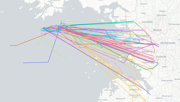
Aircraft operating near Seoul, South Korea spoofed to points in the ocean 28 to 30 May 2024. (Image: SkAI Data Services)
On the morning of May 30, 2024, Benoit Figuet posted on X that 40 aircraft operating into and out of South Korea had been spoofed over the previous 18 hours.
Professor Jiwon Seo at South Korea’s Yonsei University reports that the interference has, as of June 3, entered its fifth consecutive day.
Benoit Figuet is the co-founder of SkAI Data Services in Zurich, Switzerland. In collaboration with the Zurich University of Applied Sciences, SkAI created the world’s first public Live GPS Spoofing Tracker website. The site uses ADS-B data to detect and display in near-real time, aircraft being spoofed around the world.
South Korean military authorities have identified North Korea as the source of interference.
While the spoofing exhibits many of the same traits as interference in the Black Sea and elsewhere, Figuet has noted some differences. “We even see aircraft impacted at low altitudes,” he said. “We have observed this happening below 5,000 feet and even affecting an aircraft taxiing on the ground at the airport. The source must be at a reasonably high elevation or fairly close by.”
North Korea has a history of engaging in hybrid, non-kinetic warfare by interfering with GPS in the South, though this is the first large-scale event since one lasting from March 31 through April 5, 2016.
During the 2016 event, five different locations along the border of South Korea were identified as sources of interference. One is at an elevation of approximately 740 m and only 30 km from Inchon International Airport.
Another unique feature of the ongoing interference, according to Figuet, is the dynamic nature of the spoofed location. Unlike previously observed “circle spoofing,” the reported locations generally appear as tracing a figure eight pattern in the ocean near a point where the territorial seas of both countries meet.
Some of the spoofed locations have also been observed drifting over the North Korean border.
Local media have reported that the interference seems to be in conjunction with maritime maneuvers being conducted by the South Korean Navy and police vessels. The North has complained about intrusions into its territorial sea during these operations, a claim disputed by South Korea.
To help counter the effects of the North’s interference, South Korea has added to and upgraded its eLoran system. It has also included the eLoran upgrade in a comprehensive resilient PNT architecture that includes television signals and plans for a regional positioning, navigation and timing (PNT) satellite system.
According to Pyo-Woong Son, Ph.D., “South Korea is set to enhance its navigation and service reliability with the fully operational and established eLoran system. This system is expected to ensure that ships can navigate safely even during large-scale GPS signal disruptions, like those the country has recently experienced.” Son is a Senior Researcher at the Korea Research Institute of Ships and Ocean Engineering.
“In addition to maritime applications, eLoran will significantly contribute to the reliable operation of autonomous vehicles, such as urban air mobility (UAM), which are rapidly gaining popularity as future modes of transportation.”
“Furthermore, eLoran will play a crucial role in enhancing the reliability of public and private sector services, including broadcasting, telecommunications, and finance, where precise timing synchronization is essential,” according to Son.
Loran-C was used in many aircraft for decades before the advent of GPS. While eLoran signals are available across most of the Far East, receivers are not included in the navigation suites of commercial aircraft.
Aircraft operating into and out of Incheon International Airport have, so far, been able to use local terrestrial aviation-specific navigation aids to safely approach, land and depart.
Mr. Dana A. Goward is President of the Resilient Navigation and Timing Foundation and is a frequent contributor to GPS World.
VIAVI Solutions has launched its altGNSS geosynchronous orbit (GEO) SecureTime services designed to deliver nanoseconds-accurate UTC timing through L-Band and Ku-Band satellite signals. It is ideal for critical infrastructure including 5G networks, transportation, data centers, smart grid, high-frequency trading, military and first responder communications and satellite terminals.
The company said that operating independently of traditional GNSS, VIAVI’s altGNSS GEO service is difficult to jam or spoof and offers broad global coverage, further improving resistance to attacks.
SecureTime adds to the portfolio of solutions VIVAI offers for resilient PNT, and features navigation message authentication (NMA), which uses encryption to detect spoofing in any of the signals received from all sources — including GPS that does not support NMA. It builds on VIAVI’s existing multisource assurance, combining signals from government and commercial constellations across GEO, low-Earth orbit (LEO) and medium-Earth orbit (MEO).
These services have been tested and proven in live-sky battlefield scenarios, providing assured PNT in a simulated warzone with complete denial of GNSS signals.
VIAVI will integrate these services into its products and offer receivers for third-party solution providers to integrate into their systems. VIAVI’s SecurePNT 6200 hardware platform is powered by space and terrestrial SecureTime Services and TrustedPNT multisource fusion technology.
VIAVI is showcasing these solutions at the Assured PNT Summit on May 29-30 in Washington, D.C. and the Joint Navigation Conference (JNC) held June 3-6 in Cincinnati, Ohio.
The Baltic, Ukraine, and the Middle East may be hotbeds of GPS interference that can hamper UAV operations, but these are not the only places in the world where it is happening.
It also happened in San Diego at the premier event for UAV operators— the XPOTENTIAL 2024 conference of the Association for Uncrewed Vehicle Systems International (AUVSI).
AUVSI is the world’s largest nonprofit organization dedicated to the advancement of uncrewed systems and robotics. Members present included corporations and professionals from more than 60 countries involved in industry, government and academia and work in the defense, civil and commercial markets.
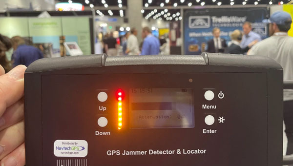
One of NavtechGPS’ directional finder identifies the source of interference at AUVSI’s Xpotential 2024 in San Diego. (Image: Dana Goward)
Among conference attendees were Franck and Trevor Boynton of NavtechGPS, a small Northern Virginia company specializing in GPS products and related services. One of their services is locating devices that are interfering with GPS reception.
“In our work around the country we have found a wide variety of devices interfering with GPS,” said Franck Boynton. “It’s a lot more common than you think. We found truckers with jammers interfering with port operations, for example,” he said. “But accidental interference is an even bigger problem. Most of the time we find it is just some malfunctioning equipment making the radio noise.”
Boynton’s experience is consistent with the 2019 European Union STIKE3 sampling project that detected more than 450,000 signals with the potential to interfere with GPS and other satnav signals. Experts determined that only about 10% of those were intentional. The rest seemed to be a byproduct of mechanical and electrical equipment not functioning quite properly.
Of course, intentional or accidental, interference with GPS signals can be a problem for both manned and unmanned aircraft, vessels and vehicles.
Intentional interference in conflict areas has turned UAVs and missiles away from their targets, and in some cases, back on attackers. It has impacted the safety and efficiency of aviation and maritime traffic nearby. As one example, regular jamming in the Baltic region recently resulted in the cancellation of scheduled commercial air service to a city in Estonia.
Accidental interference has caused survey UAVs to crash and created multi-day problems at the Denver and Dallas-Fort Worth major airports.
In at least one instance accidental interference almost ended in tragedy. In 2019 a commercial passenger aircraft near Sun Valley, Idaho nearly crashed into a mountain. Fortunately, a sharp-eyed radar controller hundreds of miles away intervened and directed the aircraft back on course.
Nearly 600 vendors filled the AUVSI XPOTENTIAL exhibit hall this year. While perusing the displays, the Boyntons detected a strong signal interfering with GPS frequencies. Thinking it was coming from one of the exhibits, they were surprised to find that not only did it turn off and on but it seemed to be moving around.
Using one of the direction finders that NavtechGPS sells, they were able to track the source to a film crew roaming the hall and speaking with exhibitors and attendees. The wireless microphone being used for interviews turned out to be the culprit. Since the film crew was unable to repair or replace the mic, the interference continued intermittently inside the hall for the rest of the event.
“Interference of all kinds with GPS and other satnav signals is a growing problem,” according to Franck Boynton. “As we continue to implement more autonomous systems, it will be increasingly important to ensure they have resilient navigation, and we eliminate as many sources of interference as possible.”
AUVSI did not respond to requests for comment for this story.
“Seen & Heard” is a monthly feature of GPS World magazine, traveling the world to capture interesting and unusual news stories involving the GNSS/PNT industry.
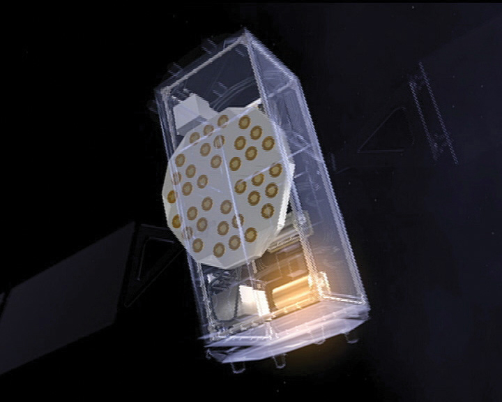
Photo: ESA
Detecting dark matter with atomic clocks
A team of researchers from Belgium’s Royal Observatory, SYRTE in Paris, the Université Côte d’Azur and the European Space Agency have used atomic clocks to search for dark matter transients in space. The team focused on a network of passive hydrogen masers (H-masers) on board the fleet of Galileo satellites to detect these transient variations. They presented a new technique that interprets fluctuations in fundamental constants as a specific kind of frequency modulation — a discrepancy in the expected times indicated by the satellite clocks. The findings are detailed in a paper titled “Searching for large dark matter clumps using the Galileo Satnav clock variations.”
Photo: H2L Robotics
Gardening Robots
H2L Robotics has deployed fully autonomous agricultural vehicles enabled by artificial intelligence (AI) across farmlands in the Netherlands. The robots are tasked with spotting and eliminating diseased tulip bulbs ahead of the country’s financially significant spring tulip bloom. The Selector180 robot uses GNSS to autonomously drive through tulip fields, and onboard cameras to take thousands of photos. An AI model then sorts the images, looking for potentially diseased bulbs. Finally, the Selector returns to the fields and removes diseased bulbs to prevent disease from spreading.
Photo: DoorDash
Deliveries from the sky
DoorDash has expanded its partnership with Wing to bring its UAV delivery pilot to the United States. DoorDash users who are near the Wendy’s fast food restaurant located at 2355 N. Franklin Street in Christiansburg, Virginia can order eligible menu items from the restaurant. They will see the new delivery option on the checkout page. Once they select the “drone” option, their order will be prepared and delivered via a Wing UAV within 30 minutes.
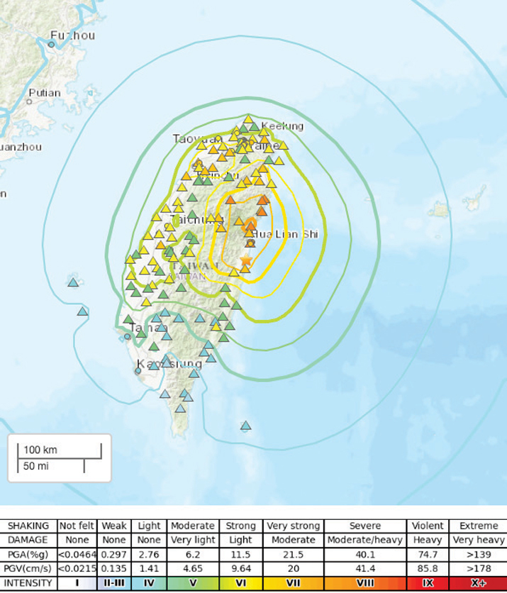
Photo: USGS
Earthquake strikes Taiwan
A 7.4-magnitude earthquake struck the eastern coast of Taiwan on April 3, according to the United States Geological Survey. USGS has released a ShakeMap providing near-real-time maps of ground motion and shaking intensity following the earthquake. According to USGS, the earthquake and aftershocks were strong enough to be felt across the island nation and parts of mainland China and Japan.
A roundup of recent products in the GNSS and inertial positioning industry from the May 2024 issue of GPS World magazine.
SURVEY & MAPPING
Photo: Virtual Surveyor
UAV With planimetric survey capabilities
The Virtual Surveyor version 9.5 now allows users to quickly and accurately survey 2D features from UAV orthophotos and add them to the 3D topographic model generated from the same data set.
True 2D features, for example, include the paint striping that delineates parking lot spaces and road lanes. Other objects that exist in 3D on the ground but can be surveyed in two dimensions include building footprints and tree canopies. These features are designed to offer a new level of efficiency to the UAV surveying process in Virtual Surveyor.
Virtual Surveyor provides users with an end-to-end workflow to conduct 3D surveys from UAV imagery. The integrated Terrain Creator app photogrammetrically processes UAV photos to build survey-grade digital surface models (DSMs) and orthomosaics. No third-party software is needed to create surveys from UAV data. The system is ideal for users in construction, surface mining and excavation projects.
Positioning System Incorporates an anti-jamming and interference monitoring system
SXblue GLOBE merges GNSS and GIS to deliver positioning accuracy, efficiency and reliability in challenging field conditions using a 448-channel GNSS board.
Its advanced multipath mitigation aims to reduce the effects of signal reflection and ensure the integrity of positioning service, even in GNSS-challenged environments. The SXblue GLOBE incorporates an anti-jamming and interference monitoring system, safeguarding against disruptions and offering uninterrupted operation in any scenario.
The system uses global or local coverage of correction services, satellite-based augmentation system (SBAS), and real-time kinematics (RTK) with an update rate of up to 100Hz. This seeks to provide users with enhanced accuracy and reliability in positioning activities. Sxblue GLOBE features a Wi-Fi connection, which allows its parameters to be easily configured via a web user interface.
3D Mapping Software With expanded visualization tools
The Surfer mapping and 3D visualization software now features upgraded 3D visualization capabilities. The upgrades are designed to give users a complete picture of collected subsurface data. The expanded visualization tools in the latest Surfer version make it easier to create 3D grid files for viewing and analysis of drillhole data.
Surfer can be used for environmental consulting, water resources, engineering, mining, oil and gas exploration and geospatial projects.
With these upgrades, users can render 3D grids as a series of blocks, which can be colorized by a select variable. Images of cross sections, profiles and other features can be imported directly into 3D View and oriented in any direction or angle. To isolate certain features in the 3D grid, users can assign NoData to portions of the grid with a variety of methods. This allows users to eliminate unwanted data in a 3D grid outside of field boundaries, well locations, or above or below specific surfaces, such as a water table, topography, or lithologic layer.
Digital Twin Platform Shows roadway incidents in real time
The Flow RT is a real-time digital twin platform designed to provide agencies with instantaneous alerts and insights for better decision-making. The platform allows traffic managers to view traffic conditions, signal operations and roadway incidents in real time, at scale across entire regions.
Flow RT integrates seamlessly with the company’s solutions, including traffic signal management, roadway safety management and mobility management. Powered by connected vehicle data from industry-leading partners, including TomTom, the platform offers up to five times higher vehicle data penetration rate than the previous industry standard. Flow RT also provides alerts and notifications while offering data-driven decision support, ensuring agencies can make the best decisions using the most accurate, reliable and instantaneous insights with and without infrastructure connectivity.
INS With an integrated acoustic resonance air speed sensor
Inertial Labs has integrated the FT Technologies FT743-D-SM acoustic resonance air speed sensor into its inertial navigation systems (INS).
This integration aims to improve the accuracy of horizontal air speed estimation for multi-rotor UAVs, even in GNSS-denied environments. The FT743-D-SM airspeed sensor is a digital anemometer-based solution that can estimate airspeed incoming from any direction using acoustic resonance technology, which is immune to vibration and external acoustic noise. The airspeed magnitude and direction allow the INS to estimate horizontal air speed in the longitudinal and lateral axes.
The INS receives aiding data from the dual-axis airspeed sensor and experiences significantly less position drift compared to a dead reckoning alternative in GNSS-denied environments, the company said. The system can be used in mission-critical roles in multiple military or defense applications, as well as in civilian applications such as wind energy, marine navigation, UAVs and dynamic positioning systems.
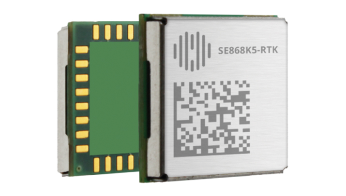
The SE868K5-RTK module is a GNSS receiver capable of centimeter-level accuracy. It is designed for seamless operation near cellular or other radios and is suitable for precision applications.
At 11 x 11 mm, the module’s compact form factor offers adaptability in size-constrained scenarios and easy migration within the xE868 product family. It is designed to offer high-performance navigation, even in challenging RF conditions. The solution can be integrated into applications such as wearables, UAVs, robots, fleet tracking and precision agriculture.
The SE868K5-RTK is a multifrequency and multi-constellation positioning receiver module with RTK capabilities that enhance positioning accuracy. By harnessing dual frequencies — L1/E1 and L5/E5 — the module offers improved location precision and reduces multipath effects.
In partnership with Swift Navigation, the SE868K5-RTK module utilizes local base stations or Swift’s Skylark precise positioning service for corrections, which offers reliable centimeter-level accuracy across an extensive coverage area. The integration and Telit Cinterion’s cellular modules and NExT connectivity services offer continuous and accurate correction data delivery to the GNSS module.
Upgraded Click Board Now with an integrated GNSS receiver module
The Septentrio mosaic-X5 GNSS receiver has been integrated into the MikroElektronika (MIKROE) Mosaic Click board.
Mosaic Click is compatible with mikroBUS socket standard, allowing plug-and-play prototyping and reduced time-to-market. The mosaic-X5 receiver uses triple-band GNSS technology to achieve centimeter-level RTK accuracy, even in challenging environments. Its anti-jamming and anti-spoofing technology protects the receiver from malicious or accidental radio interference. It is ideal for applications where safety is a concern, as well as autonomous and mission-critical applications of systems such as UAVs or industrial robots.
The mosaic-X5 receiver tracks all available GNSS constellations and is protected by Septentrio’s AIM+ anti-jamming and anti-spoofing technology. Full GNSS raw data and positioning are delivered at a high update rate of 100Hz and with low latency, which is critical for autonomous movement and maneuvering.
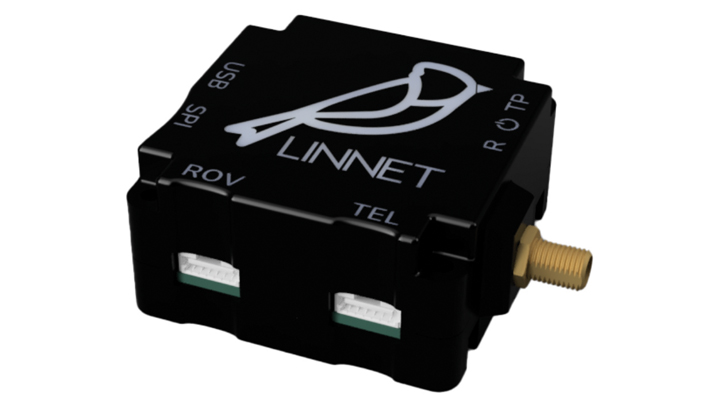
RTK Positioning Module Supports all GNSS constellations
The Linnet mosaic-X5 is a multi-band module featuring the Mosaic-X5 receiver by Septentrio. It receives signals from all major constellations and can be used both directly on the rover and as a base station. The system can achieve centimeter-level positioning accuracy and attain precise positioning even in low-coverage zones and harsh vibrations and shocks.
The mosaic-X5 module is a 448 channels all-in-view receiver that supports all GNSS constellations, SBAS and QZSS, as well as built-in on-module support for other L-band correction services. The Linnet Mosaic-X5 features anti-jamming protection and anti-spoofing built-in and embedded spectrum analyzer.
The module can be used in a variety of applications, including tracking, surveying, autonomous navigation, ground robotics, precision agriculture and machine control.
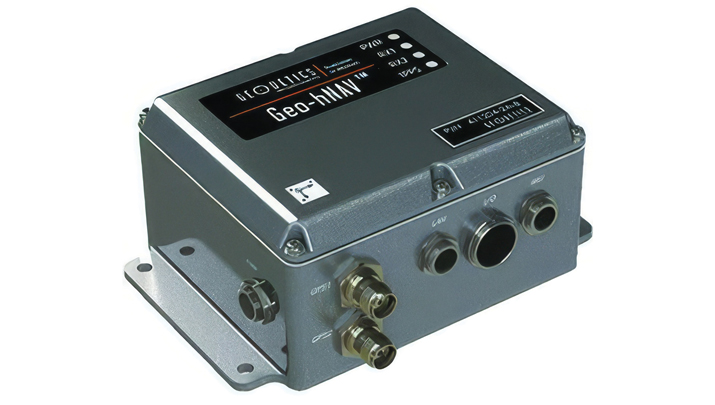
Geo-hNAV is a rugged, hybrid dual-GPS-aided INS. It offers consistent position and attitude measurement accuracy whether the platform is static or moving. The Geo-hNAV combines the Geo-iNAV INS with the Geo-Pointer dual-antenna heading system.
For stationary or slowly moving platforms, precise heading is derived from GPS measurements using two GPS antennas rigidly mounted on the platform, separated by a typical distance of 1 to 3 meters. In dynamic conditions, the combination of GPS and IMU seeks to provide enhanced position, velocity and attitude measurements. The system can be used for geo-positioning onboard sensors on static, low and high dynamic platforms such as aerostats, boats and tanks.
The C631 is a multi-GNSS, multi-frequency smart antenna. The C631 provides robust performance and high precision in a compact and rugged package. With multiple wireless communication ports and an open GNSS interface, the C631 can be used in a variety of operating modes.
C631 can be used as a precise base station sending RTK to existing rover networks. Users can turn the C631 into a lightweight rover by connecting it to a base via UHF radio or Wi-Fi network. The built-in web user interface can be used to control and manage the receiver status and operation and upgrade the C631 with new firmware and activations.
Atlas is a global correction service that can be added as a subscription to the C631. Atlas delivers worldwide centimeter-level correction data over L-band communication satellites.
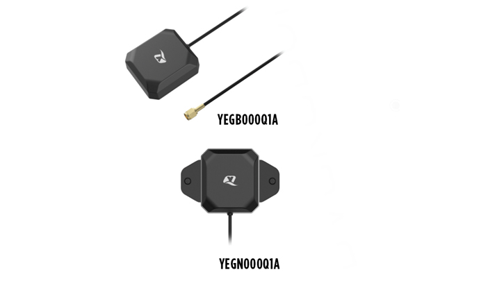
The YEGB000Q1A and YEGN000Q1A active GNSS L1 and L5 antennas are designed to tap into L1 and L5 frequency bands for advanced navigation applications. These antennas, operating within the 1164-1189 MHz and 1559-1606 MHz frequency bands, are designed to support a variety of installation methods, catering to diverse application needs with options for screw mount, adhesive mount, magnetic mount and various cable connections.
The antennas are part of a broader release that includes the YEMN016AA and YEMN017AA 5G 5-in-1 combination antennas, which also feature GNSS capabilities.
These GNSS antennas are crucial for applications that require high levels of navigation accuracy, such as autonomous vehicles, UAV delivery systems and precision farming.
The TW5387 industrial-grade smart GNSS antenna integrates the Quectel ST TESEO V GNSS receiver chipset onto the Calian compact smart GNSS antenna platform. It is designed to offer dual-band GNSS, eXtended filtering, low phase center variation, low signal-to-noise ratio and dual feed and patch for strong multi-path rejection.
The TW5387 comes with RTK rover capability and a built-in IMU for sensor fusion. It is designed to minimize RF impairments that affect the performance of the GNSS receiver and provide GNSS coordinates to the host system over a robust digital interface for noise resilience.
TW5387 is suited for automotive, UAV, robotics and defense applications that require high precision location and timing. TW5387 is compatible with N-RTK correction services such as Point One Navigation’s Polaris and Swift Navigation’s Skylark. It tracks GPS, Galileo, BeiDou and L1/L5 band operation and is housed in an industrial-grade IP69K enclosure.
The PEANGPS1005 is an active GPS/GNSS multi band L1/L2/L5 antenna with 47.5 dBi overall gain. It is IP69K rated, light weight and designed for surveying. This GPS/GNSS antenna is suited for harsh operating environments where stability and reliability of GPS/GNSS signal is required.
This antenna operates in the 1.164-1.3GHz and 1.525-1.615GHz bands, meeting GPS L1/L2/L5, GALILEO E1/E6/E5a/E5b and GLONASS L1/L2/L3 requirements. The PEANGPS1005 antenna has an integrated LNA with 2 dB noise figure and LNA gain of 40 dB.
The antenna has an axial ratio of 3 dB and can track visible satellites under extreme conditions, which is ideal for UAV navigation, autonomous tracking or GIS surveying.
Paving and Mining Solution Meets DOT smoothness standards
The MC-Max asphalt paving and MC-Max milling solutions offer modularity, simplified configurations and advanced feature sets to increase productivity in asphalt paving and cold milling applications.
The MC-Max Asphalt Paving and MC-Max Milling systems, which are made up of , total stations, displays and other high-precision sensors, are built with the new MC-X machine control platform. Users can choose from entry-level 2D systems that follow a reference, such as a string or a curb, or automated solutions that track a paver or miller in 3D.
Contractors can pave and mill at variable depths while meeting smoothness standards mandated by the U.S. Department of Transportation (DOT) smoothness standards. The solutions also include MC-X licensing options. The technology is compatible with OEM CAN-based systems and has expanded to include compatibility with additional aftermarket systems.
It is equipped with Topcon Virtual Ski intelligence software designed to simplify workflows in specific resurfacing applications, such as rural roads where there are fewer fixed points or intersections to match up to.
Reality Capture Platform Generates detailed 2D and 3D models
This UAV reality capture platform collects data through FlytBase UAVs and generates detailed 2D and 3D models on SkyeBrowse, a UAV reality capture platform.
The platform uses SkyeBrowse’s videogrammetry technology to quicly convert UAV video footage into 2D maps and 3D models, making it ideal for emergency response scenarios where rapid documentation is critical. The platform integrates seamlessly with beyond visual line of sight (BVLOS) systems, enhancing both the speed and quality of data-driven strategies in critical operations.
The E400 fixed-wing VTOL ISR UAV now features a 360° camera option. Partnering with NextVision, the Event 38 UAV now offers a range of EO/IR Gimbal camera options for seamless integration with the E400 platform.
NextVision’s gimballed EO/IR cameras capture visual and thermal imagery and video. The UAV provides live streaming directly to ground stations for continuous monitoring capabilities.
The 360° EO/IR camera integrated onto the E400 ISR can be used for search-and-rescue missions, suspect pursuit, emergency management and disaster response. The E400 ISR, built with a military-grade carbon fiber frame, offers durability for rugged field applications and allows for extended flight durations without the need for frequent recharging. It is suited for surveillance and security applications. It features electric propulsion and minimal noise emissions for discreet flight operations.
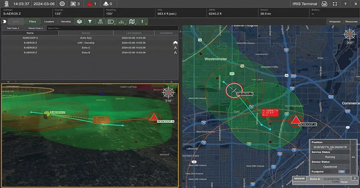
Enhanced BVLOS System Offers situational awareness to UAS operators
IRIS Terminal now features Echodyne radar technology designed to enhance Beyond Visual Line of Sight (BVLOS) operations for unmanned aerial systems (UAS) in Advanced Air Mobility (AAM) applications.
The integration seeks to provide situational awareness to UAS operators by visualizing all airspace movement, cooperative and noncooperative, to ensure safe and reliable UAS operations.
IRIS Terminal, now in its second generation, has been adapted from its defense origins to the enterprise UAS sector for visualizing airspace traffic, as well as controlling uncrewed systems in its GCS format. Airspace traffic is visualized inside IRIS Terminal’s multiple viewing configurations, along with features such as detect-and-avoid (DAA) sensor footprints, terrain awareness and potential conflict warnings.
The Inertial Labs’ RESEPI lidar remote sensing payload instrument GEN-II has been integrated into Sony’s Airpeak UAV.
The partnership seeks to enhance Airpeak’s ability to produce detailed aerial maps and 3D models.
Tailored for professionals, the lidar system integrated into Sony’s Airpeak UAV will significantly enhance workflow efficiency and data accuracy, particularly in sectors such as construction, agriculture, and filmmaking, according to Inertial Labs. The system allows for extensive data handling and facilitates longer durations of data collection without frequent offloads. The UAV can be used for surveying, mapping and cinematic videography.
The Grimaldi Satellite Autonomous Berthing (GSAB) project, funded by the European Space Agency (ESA) Navigation Innovation and Support Program (NAVISP) program, has developed a system for automatic, high-precision port berthing operations in large (200m) carrier ships. The system offers ship captains and crew with an overview of ship conditions in real time port settings, including detailed information on maneuvering operations.
Project leader Grimaldi Euromed, in collaboration with two divisions of Kongsberg, conducted the research and development of the new system, including integrating various sensors to provide accurate positioning and ranging data with high integrity. The GSAB system suggests the best path for berthing based on all available and relevant information sources, while augmented reality (AR) goggles provide an intuitive method of visualizing critical berthing information.
System subcomponents include an inertial navigation system (INS) where GNSS measurements are fused with motion/attitude data from the Kongsberg motion gyro compass (MGC). This allows the system to deliver robust and precise data on vessel location, velocities and acceleration. A perception system includes a camera-based sensor for determining steel-to-steel distances from the vessel to any obstruction and quays.
Kongsberg illustrated increased efficiency using to the new system, including a clear reduction in the time required to enter and exit from a port, and a corresponding decrease of emitted pollutants.
Radiolabs, a non-profit research organization, recently joined the GSAB consortium. It focuses on investigating and prototyping a new ground truth reference system, which integrates and fuses GNSS, IMU, and lidar-derived data to provide highly accurate positioning and ranging.
At the recent final presentation of the GSAB project, hosted by ESA, Federica Pascucci of Radiolabs described the results of the project, based in part on previous work in the automotive sector. She said the GSAB work was promising, having verified the effectiveness of Radiolabs’ lidar-based system for positioning, with adaptations necessary for application in maritime scenarios.
The GSAB project demonstrated significant potential cost and time savings benefits and improved safety and environmental performance. The partners will continue their work in the framework of a new ESA NAVISP-funded project, GSAB2, to demonstrate the system’s use in increasingly autonomous vessels and apply newly developed, advanced algorithms based on artificial intelligence.
ComNav Technology has launched the M100X GNSS receiver. It is built with the Quantum-III SoC Chip, designed to provide full-constellation and multi-frequency capabilities, specifically engineered for high-accuracy vehicular positioning and heading.
The M100X features GNSS+INS integrated technology to provide real-time high-precision positioning, velocity and heading data, even in challenging environments.
The receiver is designed to provide accurate positioning and heading information across various applications, including autonomous mining trucks, intelligent ports, mapping and autonomous buses. It is designed to safeguard vehicles as they pass through areas with poor signal reception, even in obstructed environments such as urban canyons, city overpasses underground garages, tunnels and parks.
The M100X has a data update rate of up to 100Hz, allowing it to perform well in dynamic, high-speed environments, such as vehicles traveling at high speeds. This rapid update capability enables continuous and real-time tracking of vehicle positions for reliable computation and instant updating of navigation information. It also facilitates quick responses to changes in vehicle dynamics during travel. These features are essential for maintaining seamless operation in high-speed environments and ensuring high levels of safety and performance.
Constructed with aluminum alloy and rated IP67 for water and dustproof, the receiver is built to withstand harsh operational environments. It also features a shock-resistant design, capable of surviving a drop from 1 m without damage. It can connect to 4G, LAN, Bluetooth and multiple I/O ports for seamless integration with various systems and networks.
ComNav has also released Navigation Master software, an Android app for quick device configuration and effective remote management. Using Bluetooth connectivity, users can easily configure their M100X devices for optimal performance. Additionally, its cloud platform, NaviCloud, offers instant access to projects and data from any location.
Commander, Naval Surface Force, U.S. Pacific Fleet Vice Adm. Brendan McLane is rung in upon his arrival to the establishment ceremony for Unmanned Surface Vessel Squadron 3 (USVRON 3) on Naval Amphibious Base Coronado May 17, 2024. The squadron is comprised of unmanned Global Autonomous Reconnaissance Crafts (GARCs). The 16-foot GARCs built by Maritime Applied Physics Corporation enable research, testing, and operations that will allow integration throughout the surface, expeditionary, and joint maritime forces. (Photo: U.S. Navy photo by Mass Communication Specialist 1st Class Claire M. DuBois)
The U.S. Navy has created Unmanned Surface Vessel Squadron (USVRON) Three at Naval Amphibious Base Coronado. The squadron, equipped with Global Autonomous Reconnaissance Crafts (GARCs), aims to enhance the Navy’s capabilities by integrating unmanned systems into surface and joint maritime operations.
GARCs, developed by the Maritime Applied Physics Corporation, facilitate research, testing and operations for seamless integration across surface, expeditionary and joint maritime forces. These crafts will be used for various missions, including operations with carrier strike groups and surface action groups. Additionally, the squadron will introduce a new robotics warfare specialist rating to oversee and operate these systems.
The mission of USVRON Three is to provide the most powerful unmanned platforms in the maritime domain. The squadron will play a key role in establishing the knowledge needed to operate and maintain sUSV. It will develop tactics, techniques and procedures for small unmanned surface vessel (sUSV) operations and sustainment. USVRON Three’s motto is “Victory Through Ferocity.”
Photo: Space Surveillance Operations Center (COVE)
The Spanish Ministry of Defense has awarded a $2.9 million contract to GMV, for the development, deployment support and maintenance of the Space Situational Awareness and Control System (CCSE). The system will be used at the Spanish military Space Surveillance Operations Center (COVE).
Under the contract, GMV will conduct orbit calculation and propagation, build-up and maintenance of a space object catalog (both open and classified), prediction of atmospheric reentry, calculation of overflight events, planning of observation and sensor calibration campaigns, calculation of GNSS signal degradation and integration and processing of space weather data.
This system is expected to go into service at the end of 2024. To comply with this timeline, it will be based on GMV’s Ecosstm system, which is being used in other operational environments such as the German Armed Forces’ Space Domain Awareness Center (Weltraumlagezentrum), the civilian space surveillance systems of various other countries such as Greece and GMV’s commercial space surveillance center known as Focusoc.
The COVE, which is operated by the Ministry of Defense (MINISDEF) through its Space Command (MESPA) of the Spanish Air and Space Force (EA), was created in November 2019. The center reached its initial operational capability (IOC) in 2021.
GMV has been supporting the center and assisting its participation in the Global Sentinel exercises organized by the U.S. Space Command. As part of its support, GMV has supplied its operational orbit determination tool, Sstod, for processing data from the Spanish space surveillance radar located at the Morón Air Base, near Seville, Spain.
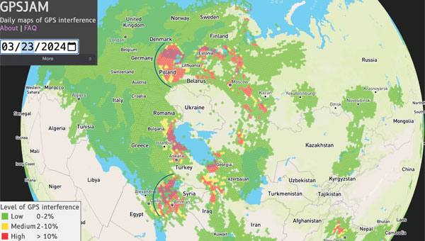
Figure 1: GPSJAM map on March 23, 2024. The map is based on GPS accuracy reports fron aircraft broadcast digital radio messages (ADS-B) over a 24-h period. A vast (uncolored) area on the globe is not covered because of no ADS-B report. Arcs are drawn over part of Europe and the eastern Mediterranean to help visualize the cone of the interference coming from potential jamming power sources. (Photo: GPSJAM.org)
GPS services are critical for real-time information on positioning, navigation and time (PNT). Because of the highly accurate and continuous PNT solution provided by GPS in all weather conditions, this multi-use technology has been adopted for civil applications including some for transportation, agriculture, aviation and emergency services. The increasing societal dependence on GPS has also created a set of security vulnerabilities for these applications.
GPS applications are vulnerable to signal interference, spoofing and degraded or denied services. Both intentional — jamming — and unintentional signal interference can cause inaccurate PNT and poor navigation performance. In addition, GPS service may be intentionally degraded or disrupted during military operations and system testing. Environments in which the GPS service is unavailable or severely degraded require alternative solutions for PNT.
Several countermeasures have been implemented to mitigate the vulnerabilities of GPS receiving systems including flex power operation and signal encryption/authorization initiated by the service provider and signal filters and adaptive antennas implemented by a user. For example, a new military signal, M-code, from GPS III satellites has an improved anti-jamming capability in both the L1 and L2 frequency bands. GPS III can broadcast signals using a high-gain directional antenna, in addition to a wide-angle, full Earth antenna, which produces a restricted area spot service by manipulating signal strength. Such flex power operations help improve GPS performance in the presence of jamming. The flex power operation is different from the so-called Selective Availability (SA), which was an intentional degradation of civilian GPS signal accuracy globally. SA operation was discontinued in May 2000, so GPS services are always available for civil applications worldwide.
However, the transparency and openness of GPS services for peaceful uses is facing a hard reality, as the balance between peacetime and wartime applications can quickly change due to geopolitical conflicts. Attacking and overcoming GPS vulnerabilities has become a fast-evolving battlefield in modern electronic warfare. Jamming and spoofing of GPS — and other GNSS — have increased substantially in the eastern Mediterranean, Baltic Sea, and Arctic regions since Russia’s invasion of Ukraine. This was officially documented by the European Union Aviation Safety Agency in Safety Information Bulletin 2022-02R1 issued in November 2023.
For example, on March 23 to 24, 2024, widespread GPS jamming occurred in Eastern Europe that impacted more than 1,600 aircraft over a period of two days and was widely reported by mass media. The source of this massive jamming event was thought to be in Russia’s Kaliningrad exclave between Lithuania and Poland. As shown in FIGURE 1, the panoramic cone in the jammed region appears to support this speculation. Similar events with large-scale jamming occurred on December 25 to 26, 2023; January 19, February 2, 12 and 14; and March 1 to 3, 13, 15 to 16 and 18, 2024, according to GPSJAM.org. In addition, Figure 1 reveals a wide area of jamming in the eastern Mediterranean where the Israel-Hamas and Israel-Hezbollah conflicts are taking place.
The increased level of GPS jamming has had a significant impact on global science observations over the conflict regions, including low-quality measurements for soil moisture, and atmospheric and ionospheric soundings, as reported in the March issue of GPS World. In addition, NASA has observed many more dropouts from in-orbit GPS receivers in recent years, which degraded the ephemeris information used for scientific data. As the pattern of apparent GPS jamming continues, alternative filtering of the spaceflight GPS data would be required to safeguard continuous science operations.
The study reported in this article aims to provide a global perspective on recent GPS jamming and degraded services. Since late 2019, commercial CubeSat constellations such as Spire have provided atmospheric measurements with much-needed global coverage and spatiotemporal sampling. The amount of GNSS data increased from about 7,000 observations per day in 2020 to about 20,000 per day in 2022 thanks to the observation demand from weather and climate research.
Table 1: Spire satellite groups and GPS satellites observed.
SPIRE CUBESAT CONSTELLATION
Spire Global has flown more than 100 Low Earth Multi-Use Receiver (LEMUR) CubeSats since 2014. These cost-effective CubeSats are used to track maritime, aviation and weather activity from space, and can be replenished at a relatively fast pace for a low-Earth orbit (LEO) constellation. TABLE 1 lists the Spire CubeSats used in this study, showing their orbital inclination, flight model ID and the tracked GPS pseudorandom noise (PRN) code ID. Spire receivers track GPS L1C/A and L2 signals for precise orbit determination (POD) and radio occultation (RO) measurements with 1-Hz and 50-Hz sampling respectively. These Spire POD and RO data collections — from November 2019 to the present — are part of a contract under NASA’s Commercial Smallsat Data Acquisition Program.
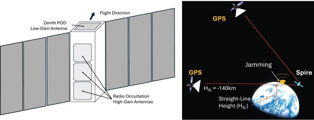
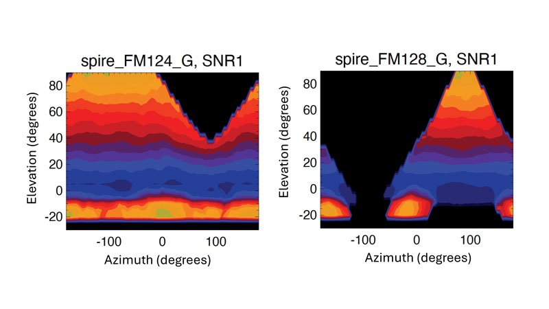
Figure 2: A schematic of the Spire 3-unit (10 x 10 x 34 cm) LEMUR CubeSat showing a zenith-view POD (precise orbit determination) and a limb-view RO (radio occultation) antenna for GPS measurements. There are usually two RO antennas on the fore-and-aft line with respect to the flight velocity, but only one POD antenna is mounted at the top. (Photo: Dong L. Wu)
The Spire LEMUR spacecraft have gone through several generations and expanded capabilities from atmospheric sounding with GPS radio occultation (GPS-RO) to GPS reflectometry (GPS-R) for soil moisture and ocean winds, grazing-angle reflectometry (GPS-GR) for sea ice and GPS-POD ionospheric sounding for space weather. In essence, however, as illustrated in FIGURE 2, these measurements are made available from two types of antennas on the satellites: a low-gain POD antenna and a high-gain RO antenna. As the measurement capability and performance improved, these antenna designs have become increasingly sophisticated and may differ substantially from satellite to satellite. Thus, it is imperative to characterize these antenna patterns carefully before comparing their signal amplitude or signal-to-noise ratio (SNR).
Figure 3: POD antenna patterns derived empirically from Spire FM124 and FM128 data as a function of elevation and azimuth angles. The elevation angle is defined as the angle of GPS line-of-sight (LOS) above the spacecraft horizon. The azimuth angle is defined as the difference between GPS LOS and spacecraft velocity azimuth angles with respect to the north. A 5° x 5° bin size was used in the averaging. Colors are the mean L1 SNR in arbitrary unit from two-month data aggregation. The antenna patterns of L1 and L2 signals are assumed to be same.
Instead of using ground calibration data, we employed an empirical method using the flight data to derive Spire’s POD antenna patterns. For each CubeSat, we aggregated a few months of POD data according to the GPS-POD link direction, in terms of elevation angle and azimuth angle with respect to the satellite flight direction. The averaging of such a large ensemble of measurements allows us to smooth out the fluctuations due to ionospheric scintillations and GPS service power variations. Two examples illustrated in FIGURE 3 show drastically different antenna patterns and designs between Spire FM124 and FM128. The larger antenna gain values at high positive elevation angles are expected for the commercial off-the-shelf (COTS) planar POD antenna pointing at zenith, whereas the gain at the bottom of negative elevation angle range is an added feature in this antenna design to enable a limb sounding of ionospheric electron density. To monitor the GPS service power, we use only the SNR measurements at positive elevation angles greater than 30° using the antenna pattern normalized by the mean values in this angular range.
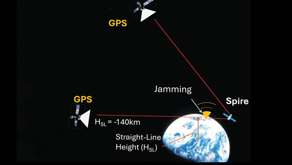
We analyzed both Spire POD and RO SNR data. The POD SNR data are used to determine the GPS service power, while the RO SNR data are used to estimate the jamming power or jammer-to-noise ratio (JNR) from the surface. The POD SNR data at high elevation angles are mostly from free space but need to be corrected for the antenna pattern effect to measure the GPS signal strength accurately. Depending on the GPS-POD link direction, the antenna pattern can cause a large variation in the observed SNR (see Figure 3). For JNR detection, we use the RO SNR data from very low elevation angles (lower than 0°) with a straight-line height (HSL) of less than -140 kilometers. At this height, a tracked GPS satellite is completely obscured by Earth and the RO receiver is essentially measuring the receiver system’s noise. Thus, any enhanced “noise” would be considered as a jamming signal. The RO antenna pattern is less critical in this case because the locations of ground jamming sources are unknown and their signals are weak at spacecraft altitudes. Roughly speaking, the RO antennas tend to acquire signals within a horizontal field of view (FOV) of 60°, corresponding roughly to a swath of about 1,800 kilometers at the surface. Therefore, the RO JNR has a coarse spatial resolution and represents a collective emission from the ground sources.
DEGRADED SERVICE AND JAMMING
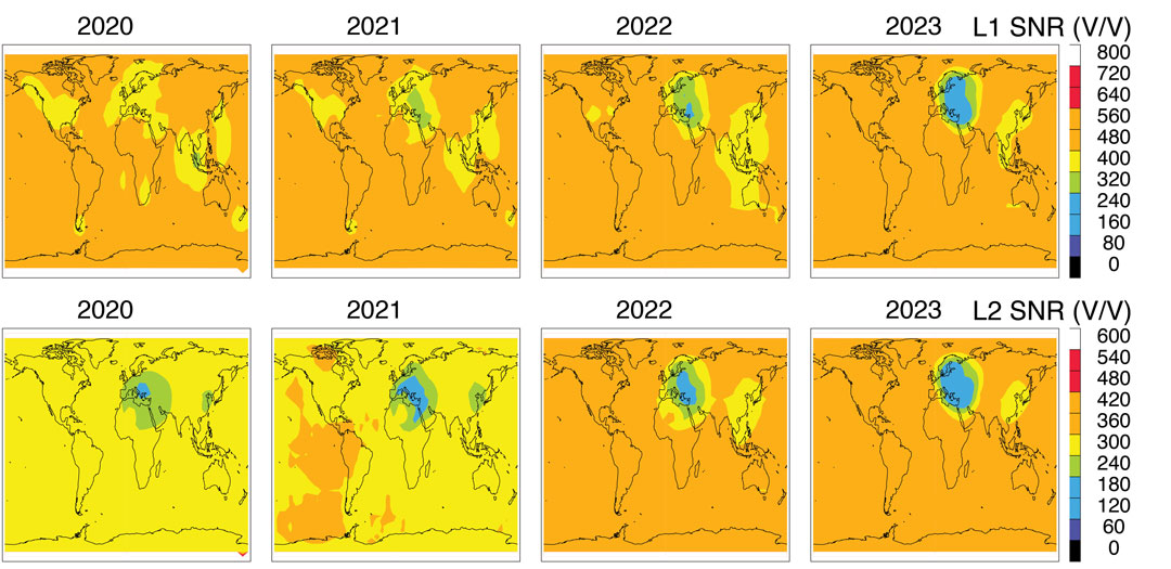
To monitor GPS service power, we normalized the Spire POD SNR with the empirically calculated antenna pattern for each CubeSat. The normalized SNR data are averaged to produce a global monthly map and then annual maps (see FIGURE 4). The L1 and L2 SNRs from Spire represent an average GPS power at an orbital altitude of about 530 kilometers. The normalized SNRs are geo-registered using the CubeSat location where the measurement was made.
Variations between different GPS satellites as well as between different Spire CubeSat altitudes are neglected in this study. Broadcasting powers from the GPS satellites may differ by a small (about 10%) amount between PRNs, which manifest themselves as a slightly inhomogeneous distribution in the maps (see Figure 4). The impacts of the Spire orbital altitude on the estimated GPS power are small, compared to the regional GPS power reduction seen over Europe.
Further improvements can be made to produce a more accurate estimate of the GPS power as well as a time series of power changes from individual PRNs.
There is a clear GPS power reduction in the L1 and L2 signals over several targeted regions. The reduction appears to differ between L1 and L2 bands during the 2020 to 2023 interval. The most prominent power reduction regions are Europe and the Middle East, where the L2 reduction started as early as 2020. Although the L1 reduction is present in this region, it deepened after 2021 and perhaps widened more in 2022 and 2023. The degraded services for a targeted region are consistent with the new capability of GPS III in operation.
Figure 4: Annual mean GPS L1 (top panel) and L2 (bottom panel) SNR distributions observed by Spire POD receivers for 2020-2023. (Photo: Dong L. Wu)
A relatively small GPS power reduction can be found in East China and Southeast Asia in the 2020 to 2023 period. The L1 power reduction in this region reveals a shift from Southeast Asia in 2019 to East China in 2023, whereas the L2 reduction appears to be concentrated in East China during these years. While geopolitical tensions in this region did not escalate to any wars, electronic warfare operations have been widely reported over the South China Sea, the East China Sea, and the Philippines since 2017.
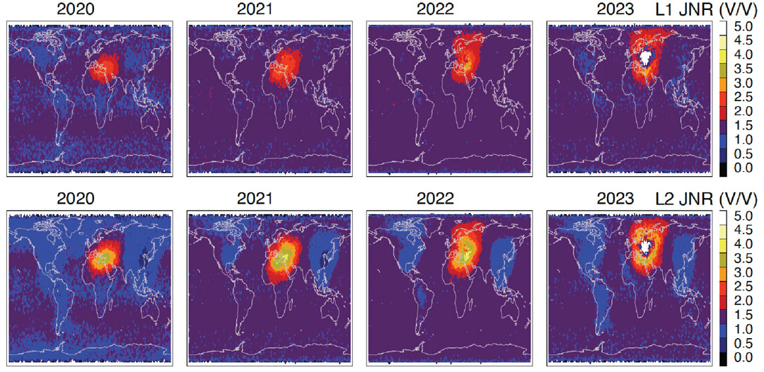
Jamming detection from space is a more challenging task because of the generally weak JNR at the height of orbiting receivers. In addition, a wide antenna FOV of GPS receivers could yield less accurate geolocation of jamming sources. However, jamming detection has been made from several LEO satellites by various teams of scientists and engineers. By tracking the front-end noise of an RO receiver on the MetOp satellite, researchers were able to detect the elevated noise power originating from ground-based sources. Also, using the radio frequency spectra recorded with a nadir-viewing receiver on the International Space Station, investigators demonstrated the feasibility of detecting jamming and spoofing signals from the ground. It has been shown that the location of jamming/spoofing sources can be pinned down accurately with observations from two satellites. This technique laid the foundation for a new class of space intelligence missions such as the DEEP prototype, STRATOS and HawkEye-360. Studying the SNR perturbations in POD data from GRACE and COSMIC-1/2, it was possible to generate global maps of jamming hotspots from 2007 to 2016. Investigators have made use of the enhanced noise in delay Doppler maps of down-looking GPS-R receivers for jamming detection. Recently, we analyzed GPS-RO SNR measurements at the tangent heights obscured by Earth and reported the increased level of jamming in northern Africa, the Middle East and the eastern Mediterranean after 2018.
Compared to nadir-view techniques, jamming detection from limb views has some advantages and disadvantages. Disadvantages have been associated with the long path length between the source and the receiver, resulting in a potentially weak JNR and poor geolocation of jamming sources. On the other hand, if jammers chose to radiate the power horizontally for a wide areal impact, it would allow limb-view sensors to pick up the jamming power and identify the directionality of jamming sources by comparing the JNR observed from opposite look angles.
FIGURE 5 As in Fig. 4 but the L1 and L2 JNR are derived from the Spire RO SNR measurements at HSL < -140 km. A 3 V/V background noise is subtracted from the SNR measurements to obtain the JNR. In 2023 the white region inside the enhanced jamming is caused by the quality control (QC) of Spire data processing that excluded the RO data with a low free-space SNR. (Photo: Dong L. Wu)
Without any sophisticated data processing, in the study for this article, we simply averaged all the RO L1 SNR data at HSL less than 140 kilometers to extract the JNR power by subtracting a 3 V/V (volts per volt) noise from the average (see FIGURE 5). This approach is slightly different from our previous study, which normalized the JNR by the free-space SNR. Because the JNR signals were so strong in 2020 to 2023, no normalization is needed to enhance the jamming detection.
It is not surprising to see in Figure 5 that the worst GPS-jammed region appears in the Middle East and the surrounding area where geopolitical conflicts have broken out frequently in recent years. In the Syria and Libya civil wars, as well as in the Russia-Ukraine and Israel-Hamas conflicts, low-cost UAVs (commonly referred to as drones) and precision-guided munitions were widely used in attacks, which was a major incentive to deploy electronic warfare to jam GPS-guided weapons and operations.
As shown in Figure 5, the JNR power was mostly concentrated in the eastern Mediterranean, the Middle East and northern Africa in 2020 and 2021 but spread to northern Europe after Russia invaded Ukraine in 2022. More JNR power appears to be in the GPS L2 band compared to L1, likely because L2 is a weaker signal and easier to jam and degrade GPS performance in navigation applications.
The regions of GPS signal reduction and enhanced jamming are highly correlated in the Spire observations. The high correlation is expected for the increased use of militarized commercial drones and GPS-guided munitions in the conflict zones. In the Russia-Ukraine war, low-cost GPS-based commercial drones have been imported to the battlefield, as have jamming capabilities. Their modifications and tactical use are evolving rapidly as the conflict continues. A precursor of such massive use of low-cost drones was in the Libya civil war (2014 – 2020), in which thousands of airstrikes were reported. Most of these commercial-grade drones relied on GPS civilian signals for navigation. Therefore, denying or reducing the GPS civilian signal power can help degrade the performance of militarized commercial drones. On the other hand, jamming and spoofing GPS signals remains a cost-effective electronic warfare technique in these conflicts.
CONCLUSIONS
This article has provided an overview of global GPS jamming and service reduction between 2020 and 2023 using recent observations from the Spire constellation. The service power reduction and jamming power increases are highly correlated on a regional scale, showing that Europe and the Middle East have been most impacted by the ongoing geopolitical conflicts. The area of the impacted regions has widened significantly from 2021 to 2023 and spread to Northern Europe. The dual-use civil and military GPS technology and services are currently experiencing an unprecedented scale of electronic warfare attacks.
ACKNOWLEDGMENT
The work reported in this article was supported by NASA’s Commercial Smallsat Data Acquisition program.
Some of us will remember that was how Sgt. Phil Esterhaus ended the morning roll call on the classic TV show “Hill Street Blues.” Although this warning was directed at police officers in carrying out their sometimes dangerous duties, it is good advice to anyone relying on GPS or any of the global navigation satellite systems (GNSS). Why? Although GPS and the other systems work very well in many environments, there are situations where the surroundings, such as those in natural and urban canyons, can block and reflect signals degrading or even denying positioning and navigation capabilities. And that’s not all. Space weather can also occasionally affect GPS and the other systems, limiting their use.
On top of such environmental concerns, we must worry about accidental and intentional disruptions of GNSS by radio frequency interference (RFI). GNSS signals received on or near Earth’s surface are fairly weak — much weaker than, say, cell phone signals — and so can be easily overpowered by nearby stronger radio signals. This is commonly referred to as jamming and there have been many instances of deliberate interference with GPS signal reception in North America and elsewhere. In fact, although its use by civilians is illegal, GPS jamming equipment is available that can stop a GPS-based tracking system from working.
On the other hand, GNSS signal jamming has become a common military tactic and its use is now widespread across the globe. While users might be aware that their navigation equipment is not working due to jamming, there is also the more insidious technique of spoofing, in which false GPS-like signals attempt to trick a receiver into using them rather than the true signals, resulting in an erroneous position report perhaps hundreds of kilometers away from the receiver’s true position.
While the use of GNSS jamming and spoofing can be detected on the ground and by aircraft overflying locations where the activity is taking place, these signals can be more comprehensively studied from space using satellites carrying receivers with appropriate spectrum coverage. In this quarter’s “Innovation” column, a researcher with NASA’s Goddard Space Flight Center reports on studies of GPS signal interference he has conducted using observations from a constellation of low-Earth orbiting (LEO) satellites that use onboard GNSS receivers to provide data for use in operational meteorology and the study of space weather and climate. However, the receivers also intercept jamming and spoofing signals as the satellites pass over conflict zones multiple times per day. It is in these zones and surrounding areas that all users relying on GNSS must be extra careful out there.
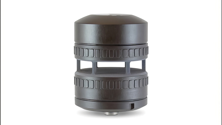
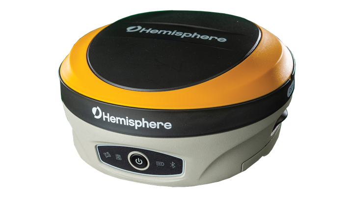
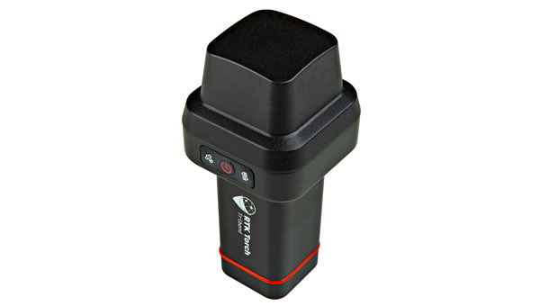
SparkFun Electronics has launched the RTK Torch, designed for high-precision geolocation and GIS needs. It has tri-band reception, tilt compensation and millimeter accuracy.
The RTK Torch can provide millimeter-grade measurements. Users can connect a phone to the device over Bluetooth and receive the NMEA output and work with most GIS software.
The RTK Torch features Zero-Touch RTK technology, which gives connected devices WiFi credentials for a hotspot or other WiFi network. The device will begin receiving corrections without any further setup, with no NTRIP credentials required. These corrections are obtained over WiFi from u-blox PointPerfect and are available in the United States, Europe and various parts of Australia, Canada, Brazil and Korea.
The system includes a one-month free subscription to PointPerfect. Additional subscriptions can be purchased if desired. If PointPerfect coverage is not available in the area, corrections from a local base station or service can be provided to the device over NTRIP, delivered via Bluetooth or WiFi.
It is housed in an IP67-rated enclosure. It is waterproof when submerged up to 1 m for up to 30 minutes when the USB cover is closed. Under the hood of the SparkFun RTK Torch is an ESP32, a UM980 L1/L2/L5 high precision GNSS receiver from Unicore, and an IM-19 for tilt compensation.
The addition of the L5 reception makes this portable GNSS device ideal for densely canopied areas where normal L1/L2 reception may have problems.
The device can be used for:
GNSS Positioning (~400mm accuracy) – also known as “Rover.”
GNSS Positioning with RTK (8mm accuracy) – using a local base station.
GNSS Positioning with PPP-RTK (14 to 60mm accuracy) – using PointPerfect corrections.