Swift Navigation has partnered with SK Telecom (SKT) to accelerate the deployment of AI-driven location-based products in South Korea.
Under the collaboration, SK Telecom and Swift Navigation are jointly operating a carrier-grade network to deliver Swift’s Skylark precise positioning service across South Korea, enhancing GNSS accuracy from meters to centimeters.
Skylark, a cloud-based solution, is designed to improve the accuracy of standard GNSS positioning, reducing it from meters to centimeters. This service plays a role in more than 8 million autonomous vehicles and devices, including ADAS-enabled cars, UAVs, vehicle tracking systems and robotic equipment.
Skylark is being used in more than 8 million autonomous and connected devices and will be introduced to SK Telecom’s customer base, including the Korea Forest Service. The partnership aims to improve positioning accuracy for various mobility platforms and is backed by stringent safety and cybersecurity standards.
A leading Canadian hydropower producer is using the Adtran Oscilloquartz grandmaster device combined with its optical cesium atomic clock to achieve new levels of precision, reliability and resilience in its power grid synchronization network.
The deployment addresses the urgent need to implement the highest standards of protection against GNSS disruptions — including jamming and spoofing cyberattacks — and helps bolster North America’s energy resilience. Featuring multi-source protection, the enhanced timing architecture offers a zero-trust approach to positioning, navigation and timing (PNT), ensuring robust and accurate synchronization. It also seamlessly supports existing services, which allows for a smooth transition from legacy timing to power grids with advanced PTP technology. For streamlined operations and assurance, the synchronization network is remotely managed through the Adtran Ensemble Controller with Sync Director.
By enhancing its timing framework with Adtran’s Oscilloquartz solution, the hydroelectric producer is designed to maintain the highest standards of cybersecurity and energy reliability in its critical infrastructure, the company said. The deployment aims to improve the stability and security of the energy supply across Canada and the United States.
The new solution includes Adtran’s OSA 3350 ePRC+ combined with the OSA 5422 to provide precision, stability and resilience against GNSS vulnerabilities. It has an all-digital design, which utilizes optical-pumping techniques, to guarantee timing accuracy and optimal stability for over a decade. This is twice the lifespan of conventional cesium clocks.
With the OSA 5422, the solution future-proofs the utility’s timing network and assures compliance with governmental regulations. It fortifies security and underscores the renewable energy utility’s commitment to maintaining a continuous, secure power supply.
The European Space Agency (ESA) has selected Syntony GNSS to supply user demonstration receivers for its low-Earth orbit positioning, navigation and timing (LEO-PNT) project.
Led by Thales Alenia Space and funded by ESA, the first European LEO-PNT project aims to enhance PNT services from LEO. This initiative is expected to improve the accuracy and reliability of navigation systems, serving a wide range of applications, from critical emergency services to everyday technologies.
Syntony will provide its ground receivers, compatible with the new LEO/PNT signals, as well as with GPS and Galileo systems. These receivers will initially assess the performance of signals from the constellation, which will start with fewer than 10 satellites. There will be 100 to 600 satellites when the constellation is complete, according to Syntony.
Although the receivers may not always be able to calculate position, velocity, and time (PVT) due to the lack of available satellites, they will be essential in evaluating signal performance when at least four satellites are visible. This allows for PVT calculations and performance comparisons with existing GNSS systems.
Syntony’s software-defined radio (SDR) receivers enable real-time adjustments to the receiver settings to evaluate the constellation’s performance. This can be achieved without any hardware changes, as the LEO-PNT constellation uses frequencies similar to those used by the medium-Earth orbit (MEO) GNSS systems.
Syntony’s Constellator GNSS Simulator will be updated to incorporate the constellation’s signals as soon as they are available. This process is similar to how the signals from Xona Space Systems’ PULSAR constellation were integrated as early as 2022.
The UK has successfully tested quantum-based navigation systems in flight. The commercial trial was led by Infleqtion, a quantum technology company, and is designed to improve resilience against GPS jamming and spoofing.
Although GPS jamming typically does not affect an aircraft’s flight path, quantum-based positioning, navigation and timing (PNT) systems aim to provide accurate and resilient navigation, complementing existing satellite systems and offering uninterrupted operations for global air traffic.
Infleqtion, in collaboration with aerospace companies BAE Systems and QinetiQ, conducted the trials at MoD Boscombe Down in Wiltshire. Science Minister Andrew Griffith participated in the final test flight on May 9. The project has received nearly £8 million in government funding as part of the National Quantum Strategy, which seeks to establish the UK as a leader in quantum technology.
The test flights included two key quantum technologies: the compact Tiqker optical atomic clock and an ultra-cold-atom-based quantum system, both tested aboard QinetiQ’s RJ100 Airborne Technology Demonstrator. These technologies are part of developing a quantum inertial navigation system (Q-INS), which aims to provide precise and resilient navigation independent of traditional GNSS.
The successful flight trials are a step towards deploying quantum navigation systems on aircraft by 2030 as part of the UK’s National Quantum Strategy. The demonstrated potential of quantum technology in enhancing navigation security is an important development for future aerospace applications.
SpacePNT, a Swiss positioning, navigation and timing (PNT) solution provider for the new space satellite market, has completed in-orbit validation tests of its NaviLEO spaceborne GNSS receiver platform. The platform is designed to deliver decimeter-level positioning and nanosecond-level timing accuracy in low-Earth orbit (LEO) and signal reception sensitivity for GTO/GEO/moon missions. Using its unique and proprietary hardware and software technology, it can operate in real time.
After its successful deployment in LEO onboard its hosting orbital transfer vehicle, the D-Orbit ION OTV SCV-011 satellite, on June 13, 2023, Space PNT conducted a series of experiments to validate the key functionalities of the radiation-tolerant technology. This is done by demonstrating multiple modes of operation, including dual-antenna and full-in-flight reprogramming using FPGA image and application software.
Flight models have already been delivered to commercial and institutional partners for these missions, said SpacePNT co-founder and CEO, Cyril Botteron.
The upcoming second-generation hardware platform reuses the same key radiation-tolerant electronics components, designed for telecom constellations. It also implements new functions to serve additional markets such as software-defined radio platforms for telecom and radar applications.
The new space satellite market refers to companies such as SpacePNT, SpaceX and Blue Origin that are developing reusable rockets to drastically reduce the cost of access to space. The growth of satellite technology and new business models, such as satellite-based internet services, have created new opportunities for private companies.
The ongoing conflict between Hamas and Israel, along with the unrest in various universities across the United States in support of Gaza Palestinians, and the continued aggression by the Houthi rebels in Yemen against shipping, are impacting several aspects of our lives, including the rising cost of gasoline.
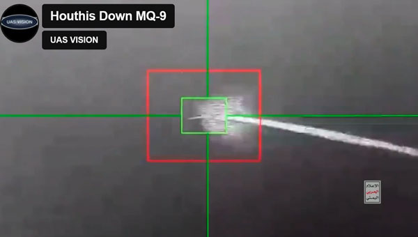
Since the United States began seeking out Houthi strongholds, it is now being reported that another MQ-9 Reaper drone has been shot down – making an apparent total of five such expensive U.S. UAVs lost over and around Yemen, according to US military reports.
Screenshot of a Houthi-released video of the downing of the MQ-9 Reaper drone (Photo: UAS Vision)
At $30 million each, compared to about $2 million for a surface-to-air missile, the Houthis are apparently ahead on cost. With a 50,000 ft ceiling, the Reaper is capable of avoiding short-range surface-to-air missiles. However, more visual or infra-red (IR) low-level detail may have been sought on this mission. In response, the U.S. military reported the downing of five Houthi UAVs over the Red Sea.
According to a Defense Intelligence Agency (DIA) report, Iran is supplying the Houthis with attack UAVs and longer-range missiles, which are often, if not always, re-assembled, repainted and re-named locally. The DIA said that one of the favorite Kamikaze UAVs used is the Iranian Shahed-136/Houthi Waid-2, which is reported to have a range of almost 1,600 miles. Neither side has yet acknowledged which drones were brought down by the United States.
However, around the same time, it was reported that perhaps two Houthi missiles hit the MV Andromeda Star oil tanker with reportedly little damage — no casualties were reported on the ship as it continued towards its destination Vadinar, India. Another ship, the MV Maisha, avoided a third missile. The missile landed nearby in the water, but the vessel put some distance between itself and the MV Andromeda, continuing safely.
The US/UK forces operating in the Red Sea have countered the more than 100 Houthi attacks on shipping with several airborne strikes on Houthi facilities. This renewed Houthi action over the weekend is thought to have been possible because they were restocked with weapons following the US/UK airstrikes, which slowed their attacks on shipping.
Hence the renewed threat to oil tanker traffic in the Red Sea has raised the already high threat level, and increased oil and gas prices at the pump are one of the consequences.
Meanwhile, Pakistan has bought 10 additional Chinese Caihong-4, which reportedly look and perform very similarly to the MQ-9 Reaper.
Caihong-4 looks very similar to the General Atomics MQ-9 Reaper (Photo: OE Data Integration Network (ODIN))
The CH-4 can be used for both attack and reconnaissance. It features a flight endurance of 30 to 40 hours, a range of 2,200 to 3,100 miles and can carry up to six weapons.
This brings Pakistan’s complement to 20 CH-4 UAVs. The new purchase may be to offset India’s purchase of 31 General Atomics MQ-9s, which is included in a huge, recently approved $3.99 billion weapons purchase from the United States. The two countries continue to feud over the contested Kashmir region.
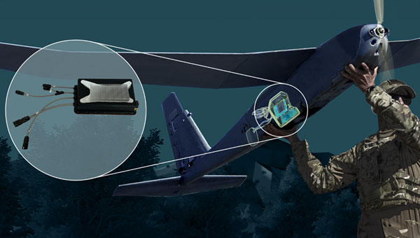
AeroVironment (AV) has developed an add-on for fielded Puma class hand-launched reconnaissance UAVs, which brings autonomy and machine-learning to a worldwide, mostly military fleet of thousands of air vehicles. Referred to as the Autonomy Retrofit Kit (ARK), with AVACORE software, the new update allows operators to command and control one or more vehicles autonomously. This provides computer vision capabilities and enables connection to a distributed, mobile comms network to access data for several separated operating groups.
ARK retrofit kit for Puma 3AE and LE UAVs (Photo: AV)
According to AV, autonomous operating tasking is possible when communications are jammed and the UAV is then still able to execute its mission without manual input. Updated computer vision allows finding, classifying, positioning and daylight or nighttime tracking of objects such as people, vehicles, aircraft and ships. AVACORE includes several software interfaces for different autopilots, sensors and radios to provide integration flexibility.
A neat way to provide significantly enhanced capability for already fielded airborne vehicles when they have some downtime.
Finally, we have a short introduction to a new transport UAV being put together by a California company called MightyFly. The company is led by a woman who was highly instrumental in the success of the flight controls for the Zipline UAV, which is still blazing drone delivery trails overseas and now in North America — with more than one million deliveries. With advisory input from a retired FedEx exec, the team at MightyFly seems well on their way with both a Federal Aviation Administration (FAA) approved Part 135 application and a 20 mile ‘point-to-point’ flight corridor approval for test flights.
Cento gen 3 cargo drone (Photo: MightyFly)
The MF-100 prototype made its first flight and demonstration delivery in April 2021, while the third-generation Cento flew for the first time in December 2022. Cento has a 6’ x 1’ x 1’ cargo hold that can accommodate 96 small USPS packages, weighing up to 100lb and Cento and later models are expected to have a range of 600 miles at up to 150 mph. While their UAVs are currently all-electric, the plan is to add a gas/rotary engine to charge batteries to achieve this forecast range for the drone.
MightyFly has significant support from the U.S. Air Force Agility Prime program and the Air Mobility Command, who continue to invest in autonomous cargo developments as an alternative to leasing helicopters to transport parts, medical supplies and more. MightyFly came up with an auto-loading capability, which resolves the issue of a potentially changing weight and balance of a last-mile cargo drone.
The National Oceanic and Atmospheric Administration (NOAA) has entered into a three-year Cooperative Research and Development Agreement (CRADA) with Verizon Frontline to refine the use of uncrewed aircraft systems (UAS) for assessing storm damage. This initiative aims to provide rapid and accurate damage assessments following severe weather events such as tornadoes and hurricanes.
Verizon Frontline will deploy its UAV technology to capture high-resolution imagery of areas affected by storms, providing crucial data to NOAA’s National Weather Service (NWS) and the National Severe Storms Laboratory. This imagery will assist in post-storm damage assessments and contribute to research aimed at understanding tornado behavior and improving severe weather warnings.
“Following a crisis, the initial imagery available is often from satellites, which may not offer the best resolution. Our goal with NOAA is to provide high-resolution imagery much faster, enhancing the support to emergency management and public safety agencies,” said Verizon Frontline Crisis Response Team member, Chris Sanders.
The collaboration represents a step forward in integrating modern technology into traditional environmental and emergency management practices, aiming to improve outcomes after natural disasters.
MerlinTPS has partnered with Bluespec to address the need for GNSS augmentation and backup technology as satellites continue to face new challenges, including wartime contested space as well as increased costs to produce and maintain satellites.
Under the partnership, MerlinTPS will develop its platform to support the expansion of PNT security capabilities by using existing signals of opportunity on the ground designed to combat jamming and spoofing.
“With our verification and validation-centric RISC-V solutions, MerlinTPS can develop customized solutions in a matter of weeks, allowing it to deliver highly differentiated products with minimal project and schedule risk,” said Charlie Hauck, CEO of Bluespec.
By implementing Bluespec’s RISC-V processors in Field Programmable Gate Arrays (FPGAs), MerlinTPS can quickly modify, generate and load new code onto FPGAs. This allows for hardware reuse, avoiding the need to build custom hardware for each task.
However, MerlinTPS can easily make customizations to Bluespec’s RISC-V soft processor cores — adding custom instructions designed to accelerate specific workloads — when needed. MerlinTPS plans to add artificial intelligence (AI) capabilities to the platform.
NASA’s Solar Dynamics Observatory captured this image of solar flares on May 11, 2024. The NOAA says there have been measurable effects and impacts from the geomagnetic storm. (Photo: Solar Dynamics Observatory)
Earth is experiencing a severe solar storm causing concern for those responsible for power grids, communication systems and satellites.
The National Oceanic and Atmospheric Administration (NOAA) has reported measurable effects and impacts from the geomagnetic storm that has been visible as aurora across vast swathes of the Northern Hemisphere. As of May 12, 2024, NOAA had seen no reports of major damage.
There has been some degradation and loss to communication systems that rely on high-frequency radio waves, NOAA told NPR, as well as some preliminary indications of irregularities in power systems.
“Simply put, the power grid operators have been busy since yesterday working to keep proper, regulated current flowing without disruption,” said Shawn Dahl, service coordinator for the Space Weather Prediction Center at NOAA.
“Satellite operators are also busy monitoring spacecraft health due to the S1-S2 storm taking place along with the severe-extreme geomagnetic storm that continues even now,” Dahl added, saying some GPS receivers have struggled to lock locations and offered incorrect positions.
As NOAA warned, the Earth has been experiencing a G5, or “extreme,” geomagnetic storm. It is the first G5 storm to hit the planet since 2003, when a similar event temporarily knocked out power in part of Sweden and damaged electrical transformers in South Africa.
As of May 13, NOAA’s Space Weather Prediction Center said that a G3, or “strong,” geomagnetic storm warning was in effect until 2 a.m. ET. While stronger storms are no longer likely and conditions are expected to “gradually wane” throughout the day, the center said in its forecast that moderate to strong geomagnetic storms are “likely” on May 13, as are minor storms on May 14.
The center also said that “solar activity is expected to be at high levels” with a possibility of more solar flares, or bursts of electromagnetic radiation from the sun.
The update came as another X-class solar flare was recorded. X-class flares are the strongest class of these solar bursts, and the latest was recorded as “moderate.”
Flares of this magnitude are not frequent,” the center said. “…Users of high frequency (HF) radio signals may experience temporary degradation or complete loss of signal on much of the sunlit side of Earth.”
Northern lights in unusual places
On May 12, people from all around the world shared photos of a dazzling display of the Northern Lights, which were visible in Russia, Scandinavia, the United Kingdom, continental Europe and some even reported seeing the aura as far south as Mallorca, Spain.
In the United States, the NOAA center shared that the storm-induced auroras were visible as far south as Northern California and Alabama.
The source of the solar storm is a cluster of sunspots on the sun’s surface that is 17 times the diameter of Earth. The spots are filled with tangled magnetic fields that can act as slingshots, throwing huge quantities of charged particles toward our planet. These events, known as coronal mass ejections, become more common during the peak of the Sun’s 11-year solar cycle.
While the storm has proven to be large, predicting the effects of such incidents can be difficult, Dahl said.
The world has grown more reliant on electronics and electrical systems. Depending on the orientation of the storm’s magnetic field, it could induce unexpected electrical currents in long-distance power lines. Those currents could cause safety systems to flip and trigger temporary power outages in some areas.
I took these photos near Ranfurly in Central Otago, New Zealand. Anyone can use them please spread far and wide. :-) https://t.co/NUWpLiqY2S
— Dr Andrew Dickson reform/ACC (@AndrewDickson13) May 10, 2024
The storm caused some navigational systems in tractors and other farming equipment to break down, suppliers and farmers told the New York Times.
Farmers have become dependent on equipment that utilizes GNSS and other navigation technology to help them plant more effectively — a practice known as precision agriculture. However, some of these operations in the Midwest, as well as in other parts of the United States and Canada, came to a temporary halt.
How it affects the ionosphere
The storm will also likely disrupt the ionosphere, a section of Earth’s atmosphere filled with charged particles. Some long-distance radio transmissions use the ionosphere to “bounce” signals around the globe, and those signals can be disrupted.
The particles may also refract and otherwise scramble GNSS signals, according to Rob Steenburgh, a space scientist with NOAA. Those effects can linger for a few days after the storm.
The storms can bring on ionospheric scintillation, which refers to rapid fluctuations in GNSS signal strength and phase due to localized irregularities in the electron density of the ionosphere resulting from solar activity. Scintillation adversely affects GNSS positioning, particularly around the geomagnetic equator after local sunset.
Similarly to Dahl, Steenburgh said that it is unclear just how bad the disruptions will be. While we still depend on GNSS, there are also more satellites in orbit. Moreover, the anomalies from the storm are constantly shifting through the ionosphere like ripples in a pool. “Outages, with any luck, should not be prolonged,” Steenburgh said.
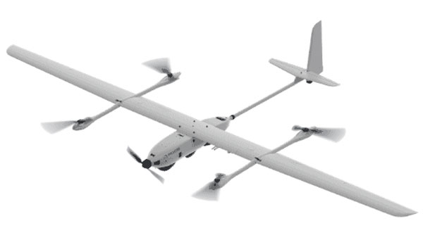
Edge Autonomy has released significant upgrades to its VXE30 Stalker unmanned aerial system (UAS) through the new “Havoc” configuration, designed to double the system’s flight endurance and payload capacity.
With the Havoc upgrades, the VXE30 can now support the complex demands of both small tactical units and larger brigade-level operations without the need for extensive reconfiguration. The upgrades are designed to make the UAS more versatile across various military applications.
The VXE30 Stalker UAS has silent, vertical take-off and landing (VTOL) capabilities and is payload agnostic with the Havoc configuration. It supports easy integration of third-party payloads and subsystems through a Modular Open Systems Approach (MOSA), requiring no additional training for current operators.
Jamming and spoofing continue to be the key challenges to military use of GNSS. While the production and adoption of M-Code receivers is delayed, defense contractors are developing several approaches to identify, locate and neutralize these threats — including CRPA antennas, embedded GPS inertial (EGI) navigators, software-defined radios and cryptography.
In this month’s cover story, executives from seven companies present their perspectives on the GNSS/PNT challenges faced by U.S. and allied military forces, their market niche in this area, and their latest products.
Lou Pelosi, vice president, CAST Navigation
Stig Pedersen, executive vice president of aerospace and defense, Autonomy & Positioning division, Hexagon
Brandon Malatest, COO, Per Vices Corporation
Tony Full, director of business development, Navigation Systems, Safran Federal Systems
Paul Crampton, senior solutions architect, Spirent Federal Systems
Joel Korsakissok, president, Syntony
Click here to read an exclusive interview with Chuck Stoffer, director of business development and Eric Hughes, design engineer, UHU Technologies
Read the related “Innovation” article.
Photo: Petty Officer 1st Class Thomas Gooley
What are currently the top two or three challenges regarding GNSS/PNT for U.S. and allied military forces? How do you expect that to change in the next three to five years?
CAST Navigation
A top challenge is anti-jamming. GPS signals are low-power and fairly easy to jam. CAST has developed a simulator for testing controlled reception pattern antennas (CRPAs), which are anti-jam antennas. CAST simulators can test CRPAs with two to seven antenna elements.
Another top challenge is preventing our enemies from using GPS in a war zone. M-Code Modernized Navstar Security Algorithm (MNSA) has been designed to support denial of GPS signals to enemy forces. CAST has developed the ability to simulate M-Code MNSA. The company is working closely with the U.S. Space Force Space Systems Command’s GPS Directorate to develop a simulator that supports all their requirements.
Hexagon
Jamming is the key challenge. The secondary challenge is getting necessary protection into fielded systems so they can be used to the full extent of their service life. Over the next three to five years, while new products designed to safeguard PNT infrastructure will emerge, the process of getting these tools authorized and integrated will remain complex.
Per Vices Corporation
GNSS signals can be disrupted or manipulated by adversaries through jamming techniques, leading to potential navigational errors or loss of positioning capabilities. Advanced spoofing techniques also pose significant challenges to GNSS/PNT for U.S. and allied military forces, as they can deceive receivers into providing inaccurate positioning, navigation, and timing information. Both can be addressed with the integration of software-defined radios (SDR) for GNSS/PNT applications where we anticipate a strong push to further advance the different anti-jamming and anti-spoofing techniques in software using high-performance SDR platforms.
Safran Federal Systems
GNSS denial and spoofing. Both challenges are expected to become more pervasive over the coming years as adversarial technologies evolve and are distributed. In the current conflict, systems are driving to become either assured GNSS or built to operate independently of GNSS clock and position information.
Spirent Federal Systems
Adversarial near-peer threats to PNT integrity are developing at an increasingly rapid pace. Navigation warfare (NAVWAR) used to focus within the boundaries of localized geopolitical conflicts, but now space-based, system-wide threats loom large and will present new challenges in the coming years. As PNT continues to evolve, more complex mitigation technologies must be integrated into a layered PNT ecosystem with shortened development and testing phases to be fielded faster.
Syntony
It is not a secret that jamming and spoofing will be the biggest challenges in the coming years: Almost every week, if not every day, we read some news about jammed or spoofed GNSS receivers, either in Eastern Europe or elsewhere.
Technology exists to protect against both threats: authentication, cryptography and CRPA. However, you cannot deliver an M-Code or PRS receiver to every soldier and every vehicle, if for no other reason than the difficulty of broadcasting the keys. The solution will pass by an intermediate level of anti-jamming and anti-spoofing receivers, which do not need them, associated to moderate prices and lighter infrastructure so that everybody and every vehicle can be protected.
For industry, it will pass through the generalization of CRPA architecture for the receivers, even for non-encrypted signals, and even with lower efficiency levels (update rate, J/S, etc.) corresponding to low dynamic movement.
What is your company’s niche regarding military GNSS/PNT?
senior software engineer Neil O’Brien utilizing a CAST-8000 GNSS simulator to analyze CRPA trajectory data. (Photo: CAST Navigation)
CAST Navigation
We are known for correctly interfacing with the military’s embedded GPS inertial (EGI) navigators.
Hexagon
We have carved out a distinctive position in the military APNT sector. We provide receivers that give users access to the entire GNSS spectrum, fortified by our unique GNSS Resilience and Integrity Technology (GRIT). Hexagon also produces anti-jam antennas designed to safeguard GNSS receivers, offering our customers tested protection in hostile environments.
Per Vices Corporation
We design, develop, and build high performance software-defined radio platforms and associated firmware/software for use in GNSS/PNT systems. This includes the use of SDRs for simulating hostile RF environments to test existing equipment, providing anti-jamming and anti-spoofing solutions, implementing dynamic frequency hopping, and signal authentication and integrity verification.
Safran Federal Systems
We are uniquely positioned to fulfill solutions to GNSS denial and spoofing through our precision timing, assured GNSS (M-Code/SAASM) and inertial navigation technologies. Additionally, we have these technologies often combined in different form factors to serve platform needs. When planning for missions, we offer our customers a full suite of mission simulation capabilities expediting the fielding of technologies by assuring functionality in a lab environment.
Spirent Federal Systems
We find our niche in partnering with industry and military institutions to provide innovative test solutions. Spirent NAVWAR test solutions enable PNT receivers to mitigate the effects of current and prospective threats. This involves new secure encrypted signals, space-based assets in a variety of orbital configurations, antenna and processing techniques, non-U.S. PNT systems, and non-satellite sensors to name a few. Research into potentially useful PNT systems is also efficiently conducted using simulation techniques — without the need to develop and iterate expensive hardware. Working with industry and military partners allows Spirent Federal to engage at the earliest stages of research and development, allowing system integrators to benefit from the same test methodologies used by the developers.
Cerber CRPA receiver with four-channel antenna and Constellator CRPA simulator. (Photo: Syntony)
Syntony
We have developed two technologies aiming at addressing this problem: a high-end CRPA receiver based on non-encrypted GPS/Galileo signals bringing state-of-the-art anti-jamming capabilities and anti-spoofing ones even with open signals, and the same for high-end 4 CRPA simulators with up to 8 channels. We developed the latter with the U.S. company Keysight and will demonstrate it at ION Joint Navigation Conference (JNC) 2024.
What is your latest product in this area? What are its key specs? What is/are its main application/mission area/s?
CAST Navigation
We have merged the EGI test capability with a CRPA tester. This allows testing an EGI that is driven by a CRPA in a jamming environment. This simulator also will be available with M-Code MNSA in the future.
a hexagon gajt in action on a U.S. Army M1A2 Abrams tank. (Photo: Sgt. Andrew Greenwood)
Hexagon
GPS Anti-Jam Technology (GAJT) antennas from Hexagon’s Autonomy & Positioning division mitigate against jammers to ensure the continuous signals required for calculating position and time remain available. GAJT is a commercial off-the-shelf product, which ensures short-order lead times and quick deployment. GAJT antennas from Hexagon can protect against between two and six simultaneous jammers. In addition to protection, they provide situational awareness messages to indicate the presence of jammers.
Our upcoming product in this area is an anti-jam antenna characterized by its low size, weight, power and cost (SWaP-C). It will protect L1/L2 and pass through all other GNSS signals to ensure resilient positioning. This addition to the battle-tested GAJT product family means that powerful, proven anti-jam protection will be available for all platforms, including UAVs. GAJTs provide assured and resilient PNT data for NATO forces worldwide on land, at sea and in the air.
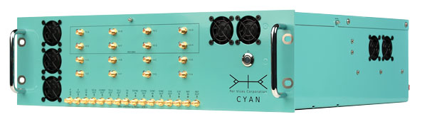
PER vices cyan software-defined radio for GNSS/PNT applications. (Photo: Per Vices)
Per Vices Corporation
Our latest product in this area is our Cyan SDR, which offers up to 16 radio chains, tuning frequency spanning all GNSS/PNT frequency bands (near DC to 18 GHz), a high performance FPGA SoC on-board (Intel/Altera Stratix 10), and multiple inputs and outputs for timing and synchronization with other equipment. This system has been utilized for many applications in this space due to its flexibility, performance, form factor (19″ 3U), and value.
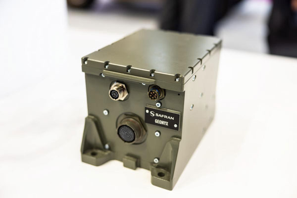
SAFran federal systems’ Geonyx inertial navigation solution, which can be integrated with VersaPNT, Safran’s all-in-one Assured PNT device. (Photo: Safran Federal Systems)
Safran Federal Systems
Safran’s Versa-PNT product coupled with a Geonyx inertial navigator offers rubidium oscillator precision timing, M-Code receiver and navigation-grade inertial technology, all in a package that can support land or maritime operations. More specifically, this package delivers:
P — M-Code receiver.
N — < 0.02% drift over the traveled distance (~2 m over 10 km, GPS accuracy).
T — One-day holdover below 1 µs.
Photo: Spirent Communications
Spirent Federal Systems
The PNT X is Spirent’s innovative sixth-generation simulation platform, which launched at the end of April and will debut at the ION JNC 2024 in June. PNT X offers a new era in NAVWAR testing, with a record 140 dB high dynamic range to simulate high-powered jammers and spoofers. It offers a 2,000+ Hz update rate for a highly accurate representation of the motion of missiles, rockets, and UAVs, thereby guaranteeing the integrity of test results.
The platform includes spatial awareness simulation for jammers and signals of opportunity, overlaying motion on user-defined signals and jammers alongside the simulation of the local environment and terrain.
The PNT X uses Spirent’s custom-built software-defined radios to extend capacity, automation and ease of use for testing current and future PNT sources. Designed for secure environments, the simulation solution features the first M-Code Regional Military Protection (RMP) test capability. Spirent experts are available to assist with generating test scenarios and capitalizing on new automation and interoperability features.
Syntony
The CRPA simulator that we will market together with Keysight will support all available GNSS signals and carrier frequencies. It also will be expandable by a software upgrade to LEO PNT in the near future. With typically four or eight channels,130dB of J/S, and based on the unique generator of Keysight VXG-C (2.5 Ghz instantaneous bandwidth, providing high-level phase synchronization all along the band), it will generate all the GNSS signals in L and S bands through one RF channel, bringing unrivaled performance and ease of calibration.
An interview with Chuck Stoffer, director of business development and Eric Hughes, design engineer at UHU Technologies. Click here to read more from this cover story.
UHU 1000 seven-element antenna array on a U.S. Army Stryker vehicle. (Photo: UHU Technologies)
What is your company’s main differentiator in the market?
CS: Our big differentiator is our ability to detect and mitigate GPS spoofing. There are many products that perform jamming mitigation using multi-element antenna arrays, but they usually don’t operate below the noise floor on spoofers. Our big differentiator is the ability to go underneath the noise floor and locate the spoofing threat.
About 10 years ago, our founder, Jeff Sanders, got interested in the GPS spoofing problem. Jeff’s previous company, Eclipse Electronic Systems, was dedicated to building high-end signals intelligence (SIGINT) receivers and the entire design team here at UHU worked for Jeff there. We built high-end, multi-channel receivers, often used in direction finding applications. When we started UHU, Jeff’s idea was to use direction finding to validate the constellation using satellite position.
EH: Our system looks like an anti-jam system, which it is. However, it does a whole lot more than that. We use a controlled reception pattern antenna (CRPA) to do angle of arrival (AOA) measurements on each GPS satellite.
We know where each satellite is supposed to be, then we calculate where it actually is in the sky. If a satellite is in the right spot in the sky, then we know that we can trust it. If it’s not — and, especially, if multiple satellites are not in the right spot in the sky — then we know there’s a spoofer.
Once we’ve done that, we can take it a step further and perform non-adaptive spatial nulling, subtracting out the bad PRNs from the signals.
Often people look at our system and think, “Oh, it’s an anti-jam system.” Yes, we do anti-jam, just like any other vendor out there would do, and we do the traditional adaptive null steering techniques, so that if there’s a jammer in the environment, we will automatically null it spatially. However, those systems don’t handle spoofers, which, as Chuck was saying, are often below the noise floor. Anti-jam systems — which are using power minimization techniques — will not do anything for something that’s below the noise. In fact, they may inadvertently amplify the weak signal because they weren’t designed to process signals below the noise.
As far as outputs, we provide a spatially validated PNT solution, meaning that we only include satellites whose sky position has been validated. We also provide an RF output that can feed other GPS receivers, including M-Code. Our products have a built-in web-based GUI for visualization of the threat environment, and all system measurements can be sent over the network using multiple industry standard protocols.
To “precisely geo locate the source of GPS jamming or spoofing threats,” as one of your marketing materials says you can do, requires at least two bearings and the range.
EH:One of the nice things about our approach is that once we’ve identified a spoofer or a jammer, we can then tell you the line of bearing or the angle of arrival from the threat. Both of our products — the Northstar and the UHU1000 —also have a built-in event-based I/Q recorder and a GPS-disciplined oscillator that provides precision time. That gives us baseband data with precision timestamps anytime there’s a spoofing or jamming event. This is a standard feature that’s available right now.
You can take multiple systems, network them together, and, if they all have a common view of the interference event, use the provided lines of bearing and precision time-stamped I/Q data to perform geolocation based on AOA and/or time difference of arrival (TDOA). This is a separate appliance that’s in development.
In our next software release we are adding single-receiver, AOA-based geolocation. However, it requires motion. So, if you have a single UHH1000 in motion, you get a coarse geolocation automatically.
CS:We’ve already demonstrated our geolocation algorithms on real-world data and our geolocation appliance is on our roadmap. We’ve proven the technology, and now we’re productizing it.
This works very well for aerial platforms, because you get a lot of motion and many different looks at it. For ground-based applications, where the source could be many miles away and the AOA doesn’t really change much, it might not be as useful.
How it the threat evolving and how are you dealing with that?
EH: One of the advantages of our AOA-based approach is that it’s outside of the signal. It’s a physics thing that is very hard, if not impossible, to spoof. At government-sponsored events, every year they throw a new attack at the participants, often by modifying the signal in some novel way. Those are all great things that need to be tested, but we don’t care about any of that because all we’re doing is checking whether a satellite is in the right spot in the sky. If it’s in the right spot, we trust it. If it’s not, we don’t. Because of that, we’re well positioned to handle new threats.
CS: We individually track every GPS satellite signal that we detect, even the same repeating pseudorandom noise (PRN) code coming from a different AOA. Each PRN gets its own hardware-accelerated tracking loop with its own beamformer. Once we know which PRNs are valid satellites and which PRNs are spoofers, we group and demodulate them separately. We provide the spoofer PNT solutions to the user in real-time.
Are all your boxes multi-constellation?
EH:Today, we process L1 C/A and L2C. Since L1 C/A is the backbone of most GPS receivers, effective spoofing attacks always spoof L1 C/A, and that has been our focus area. Of course, we have a roadmap to do more.
To the extent that you are at liberty to tell me, who has your box? Who will have it?