Tokyo-based satellite company ArkEdge Space Inc. has signed letters of intent with three international organizations to develop a PNT satellite network in low-Earth orbit (LEO).
The agreements with TrustPoint Inc., the Royal Institute of Navigation in the United Kingdom and FrontierSI aim to strengthen satellite-based PNT capabilities for civil, commercial and security applications.
The collaboration represents an early phase in ArkEdge Space’s effort to build international partnerships for PNT infrastructure. The company, which designs and operates small satellite constellations, said the project will focus on improving resilience of positioning and timing systems that support critical infrastructure.
The partners plan to examine policy frameworks and national PNT strategies as the project moves into a demonstration phase. ArkEdge Space said it will expand its network of international partners to support the development of space-based positioning systems.
“By working together, this collaboration represents an important step as we accelerate the development of resilient, trusted PNT capabilities that support critical infrastructure and informed decision-making worldwide,” ArkEdge Space CEO Takayoshi Fukuyo said.
TrustPoint has transmitted its first Low-Earth Orbit Navigation System (LEONS) time-transfer and tracking signals from a ground node to spacecraft in orbit. The milestone advances the development of commercial navigation infrastructure independent of GPS.
GNSS satellites require knowledge of their own time and orbital position to provide accurate data to Earth-based users. Most LEO spacecraft currently rely on GPS or medium-Earth orbit (MEO) signals for that information. Interference and jamming are increasingly affecting these LEO connections, degrading or blocking signals.
LEONS provides GPS-independent time transfer and orbit tracking. Initially developed for TrustPoint’s planned constellation, the system can be adapted for other LEO operators requiring timing and navigation for their spacecraft. The ground-to-space infrastructure is designed to support a GPS-independent PNT layer in orbit.
“With the pace of modern threats accelerating, the difference between concepts and capabilities matters,” said Nicole Hilliard, director of government programs at TrustPoint. “This milestone demonstrates that commercial partners can field resilient, GPS-independent PNT capabilities that strengthen national security architectures and justify continued investment in companies that deliver.”
The demonstration supports TrustPoint’s participation in the SpaceWERX AltPNT Challenge, which awarded the company two contracts to develop alternative PNT capabilities. The program seeks to deploy new options for precise, dual-use PNT systems.
To celebrate 30 years of the Galileo global navigation system, the European Space Agency created the following video. Astronomer Galileo Galilei makes an appearance.
“Three decades of challenges and triumphs that have shaped the navigation systems we rely on today: EGNOS and Galileo, and that serve as a legacy to building the satellite navigation systems of tomorrow,” states ESA.
In October 1995, the ESA Council at Ministerial Level approved ARTES Element 9, initiating the studies and development of GNSS-1 (EGNOS) and GNSS-2 (Galileo). However, the first steps leading to this moment started as early as the 1980s, with pioneering research and studies conducted by ESA, national space agencies and European institutes.
Greece now has its own internet of things (IoT) nano satellite in space, the MICE-1 (Maritime Identification and Communications systEm). MICE-1 was launched Nov. 28 aboard a Falcon 9 rocket from Vandenberg Space Force Base in California, as part of the Transporter-15 mission by SpaceX.
MICE-1 is the first Greek nanosatellite specifically designed for maritime and IoT communication applications. Developed at the Prisma Electronics facilities in Alexandroupolis, it aims to bring Greek shipping — and critical operational infrastructures in natural disaster scenarios — closer to the capabilities of space.
MICE-1 will collect and process shipping and environmental data in real time using artificial intelligence and advanced encryption techniques to ensure secure data transmission and analysis. It also paves the way for Greece’s presence in the field of space applications.
With real-time data collection and secure, two-way communication, MICE-1 contributes to reducing environmental footprint and promoting green technologies in shipping.
MICE-1 is a 3U CubeSat nanosatellite equipped with an AIS receiver to record, identify and track ship signals, as well as an S-band IoT communication system. The satellite’s objective is to establish direct communication with ships equipped with LAROS technology — Prisma Electronics’ innovative platform that facilitates the operational monitoring and optimisation of ocean-going vessels.
MICE-1 enables LAROS to leverage the capabilities of space, providing new tools for sustainable and efficient shipping. The company will also use the nanosatellite to optimize and evaluate the artificial intelligence algorithms it has developed, with the aim of assessing functionality impairment, predicting behaviour and managing telemetry in line with high cybersecurity standards.
A team of specialized engineers from Prisma Electronics participated in development of the nanosatellite in close collaboration with the European Space Agency. Operation of the main ground station was supported in collaboration with Democritus University of Thrace.
To meet the requirements of the mission, Prisma Electronics collaborated with international partners in the space sector, including SpaceX, Exolaunch, EnduroSat and IC-Space.
Prisma Electronics is already planning the next phase: the development of a comprehensive satellite IoT network for use in shipping, environmental monitoring and civil protection. The MICE-1 mission demonstrates that Greece is not just observing international space developments, but actively contributing to shaping them.
Carried out under the supervision of the European Space Agency (ESA), the mission is part of the Ministry of Digital Governance’s national IOD/IOV CubeSat nanosatellite programme, which forms part of the Greece 2.0 initiative. This programme is funded by the European Union’s Recovery and Resilience Facility (RRF).
Today’s commercial innovation requires infrastructure that moves at the same pace.
Essence
The rise of commercial satnav
Everyday life is saturated with location-dependent devices. They are multiplying faster than ever and their requirements have surpassed what GPS can support. Innovation in low-Earth orbit (LEO) satellites have seen exponential growth in the last ten years, unlocking new possibilities in further connecting our world.
In 2016, the total number of satellites operational in space from commercial and government operators was approximately 1,500. This number had been stable for decades, with linear growth since the launch of Sputnik in 1957. Today, there are now more than 8,000 satellites operational in space — with nearly all growth happening in LEO.
There are multiple reasons why. The cost of space access has decreased with reusable rockets and greater competition. The demand for connectivity has driven deployment of multiple constellations to deliver Internet from space. Latency is extremely important in communications and resolution in Earth observation.
While innovation in LEO satellites has primarily focused on connectivity and Earth observation, there is a generational opportunity to innovate in the position, navigation and timing (PNT) infrastructure that silently powers modern life.
There are now more than ten entities working toward deployment of dedicated PNT functions in LEO, amounting to more than 2,500 satellites if every constellation was complete today. As shown in Figure 1, five of these entities have already collectively launched more than 50 satellites. This market signal is not surprising, as demand for greater precision, power and protection are becoming fulfilled with diversification in LEO.
Figure 1. Launches of LEO PNT satellites.
Essentials
Medium-Earth orbit (MEO) has been the traditional choice of satellite navigation for global systems, with GPS, Galileo, BeiDou and GLONASS all being deployed in this regime. This altitude in the outer Van Allen belts is the harshest radiation environment Earth orbit satellites are subjected to and is a major driver in the cost and complexity of the satellites. From a commercial standpoint, deployment in LEO is more attractive as the more benign radiation environment allows for the use of more commercial off-the-shelf (COTS) parts in satellite designs, facilitating volume production. With a healthy ecosystem and supply chain now developed around LEO for both satellites and launch vehicles, the opportunity for commercial PNT to set a new standard in performance and protection is open.
The time for innovation in PNT could not be more urgent. Innovators are pushing the frontiers of technology across every industry and market. Physical intelligence is proliferating in the form of self-driving cars, humanoid robotics, automated farming, unmanned aerial systems and more. As these systems begin to coexist in the real world, the tools they rely on have never been more at risk. Commercial aviation is regularly jammed in Europe and the Middle East due to ongoing conflicts. And ships at sea are struggling to adapt to an environment where spoofing is commonplace.
The commercial world has different and increasingly more stringent requirements than government-focused systems like GPS. GPS was designed primarily around military requirements and is longstanding infrastructure that is difficult to change with the myriad number of deployed devices that depend on it. This responsibility makes GPS too big to fail, but also incredibly difficult to change.
GNSS infrastructure has unlocked so much in commercial activity. There are now more devices using GNSS than the Internet, and GPS is by far the majority user of the technology (based on nearly 7 billion active GNSS devices on Earth and around 6 billion users of the Internet.) However, commercial users have limited input to the evolution of GNSS constellations, which has led to a widening gap between technology and wants, which provides for the current commercial opportunity.
Simply put, today’s commercial innovation requires commercial infrastructure that moves at the same pace to support.
Elements
Architecting LEO PNT
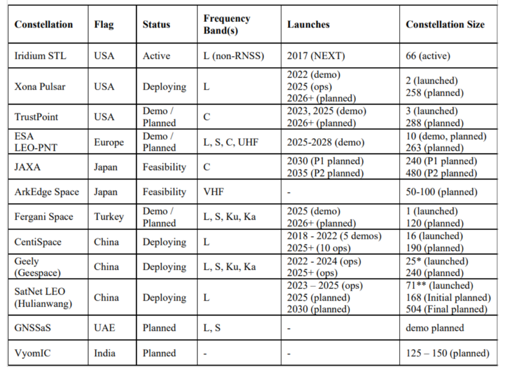
For a LEO satellite navigation system, many designs could be considered, as reflected in Table 1 from Reid et al. (2025) outlining current public information about systems already announced. These constellations range from government-supported systems, which could act as extensions of already deployed global or regional systems, to commercial systems that target potentially unique, independent markets.
Table 1. Comparison of dedicated LEO PNT systems, deployments, and plans. Note that satellites already deployed were verified on celestrack.org .
These constellations all have one thing in common: they aim for between 200 and 300 LEO satellites. The reason is simple: as LEO satellites have a footprint of approximately 1/10th that of medium Earth orbit (MEO) satellites, and between 20 and 30 MEOs are required for global PNT, approximately 10x more LEOs are needed to obtain similar coverage. A consequence is that in LEO, the radio energy is spread over 1/10th the area compared to MEO, which has implications for power needs at the satellite — 10x less in LEO for the same MEO power in the same band.
There is another crucial parameter to consider in LEO PNT design: spectrum. Table 1 shows that many approaches are being considered. Xona’s approach with its Pulsar constellation was centered around three major areas of commercial appeal: seamless operation with existing devices; increased native accuracy; and added resilience to jamming and spoofing. An important philosophy adopted early in the company’s culture was to not make development a science project — that is, do not reinvent the wheel, but rather upgrade the engine. GPS was a revolutionary technology, which is why it is so heavily adopted and brings so much value to the world. Therefore, stand on the shoulders of this giant to look out to the future.
Ease of integration was the first consideration, as it has been the most important aspect in accelerating adoption of any new system. And spectrum is key to Integration. By launching a new system that uses the existing L-band signals, the GNSS ecosystem producing approximately one billion new units per year can seamlessly upgrade their capability without new hardware. Xona’s first technology pathfinder satellite in 2022 validated this hypothesis. While the pathfinder mission supported two satellite frequencies already in the regional navigation satellite system (RNSS) bands — one near L-band E6 and the other in the yet unused C-band near 5 GHz — it became apparent that receiver companies were willing to develop hardware for the L-band signal, and did so quickly with their existing hardware. There was resistance and longer timelines to global adoption for C-band signals.
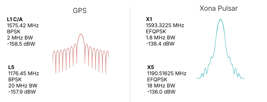
In response, Xona shifted the production signals to a dual L-band system, which already has nearly a dozen commercial receiver partners tracking the recently launched production satellite — some within weeks of the launch. The challenge is to choose a waveform that is near existing GNSS bands, familiar in form and function and digital signal processing techniques to what is already fielded today, and to not cause harmful interference to the existing GNSS services in orbit. The resulting design is shown in Figure 2, on the right. The key innovation was the selection of a bandwidth efficient form of quadrature phase shift keying (QPSK), which focuses the energy in the central lobe and rolls off quickly compared to a traditional binary phase shift keying (BPSK) signal, shown in Figure 2 on the left for comparison. The result is a 100x stronger signal that does not cause harmful interference to existing GNSS signals, while offering resilience through more signal power. This selection process was iterative, taking feedback from the receiver community. More information on the design and testing for compatibility can be found in Reid et al. (2025).
Figure 2. (Left) GPS BPSK-based signal waveform, and (right) Pulsar QPSK-based signal waveform.
In addition to compatibility and ease of integration, accuracy and resilience are critical design drivers. For example, farmers rely on their equipment positional accuracy to efficiently distribute seeds, fertilizer and water, reducing waste and improving crop yields. Positional accuracy also enables accurate, repeatable field operations year after year, saving time, fuel and money while protecting the soil. Because GNSS typically offers meter-level positioning, today many farmers buy positional accuracy through GNSS correction services to obtain centimeter-level positioning. The Xona architecture leverages these techniques in precise point positioning (PPP), delivering precise ephemerides direct from the space segment, and combining them with the fast motion from LEO satellites (compared to MEOs) to reduce position solution convergence times from ~10 minutes to nearly instantaneous (see, for example, Mah and O’Keefe, 2025). This geometry also boosts coverage, as correction services today typically rely on geostationary satellites and do not service high latitudes, where they would benefit missions such as mining operations for critical minerals and polar navigation.
Connectivity relies on resilient timing. Passing more data through a network means efficiently meshing data packets in synchronized manner. Telecommunications and data centers need such connectivity to function. Authentication is expected in our communications systems, which is largely unavailable in civil GNSS signals. In an age where GNSS spoofing is done to cheat at games like Pokémon Go and now more frequently for nefarious purposes, authentication becomes essential for a modern system (Anderson, 2025, and Xona, 2025a). For resilience to spoofing, Xona included not just data authentication, but also range authentication, so that users can ultimately authenticate their position.
Defense applications require resilience to jamming. World conflicts, particularly currently in Ukraine and the Middle East, have showcased GNSS vulnerabilities in the presence of widespread GNSS jammers. However, this problem is no longer only a defense issue. In 2025, nearly 123,000 commercial flights in Europe were disrupted between January and April alone by GNSS jamming (GPS World, 2025). For resilience to jamming, one method is more power. LEO being 20x closer to Earth than MEO affords nearly a 10x boost in power for the same power transmitted at the satellite. Xona’s target was 100x more power to the end user to significantly reduce the effective range of a jammer by more than six times as shown by recent field trials. Such a transmission power translates to a >97% reduction in affected area and means threats shift to larger and less practical platforms for adversaries, i.e., from requiring handheld devices to backpacks or even truck-sized jammers.
More signal power also has implications for indoor positioning. Internet of things (IoT) devices such as asset trackers are commonly affected by signal obstruction and attenuation during transit, particularly in indoor environments, urban canyons, under foliage, or when obstructed by vehicles and cargo. Warehouses, shipping containers, and other constraints limit where position can be determined. Even coarse indoor positions can support operational intelligence for asset management.
Launching LEO PNT
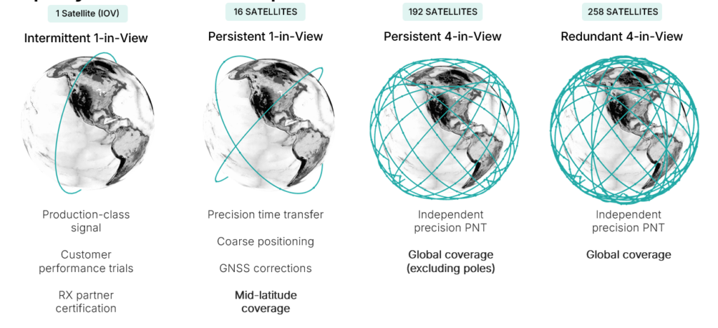
Pulsar is designed to launch in stages as shown in Figure 3, which unlocks capability in tranches that expands the number of features and ultimately the user base. While Pulsar will achieve persistent coverage across major markets at the deployment of 16 operational satellites, earliest customers in time transfer will see value from Pulsar much sooner as an independent source of timing synchronization for devices with holdover clocks. At 16 satellites, Pulsar will achieve persistent 1-satellite-in-view service, unlocking precise time transfer and coarse positioning for stationary users, including indoors. Pulsar also provides a link to stream GNSS corrections, building on a partnership with Trimble. Full resilient positioning will come online with GPS-level satellite visibility. First in the midlatitudes, with 192 satellites, and then globally with the deployment of an additional 66 satellites into polar orbit, bringing the total to 258 operational satellites.
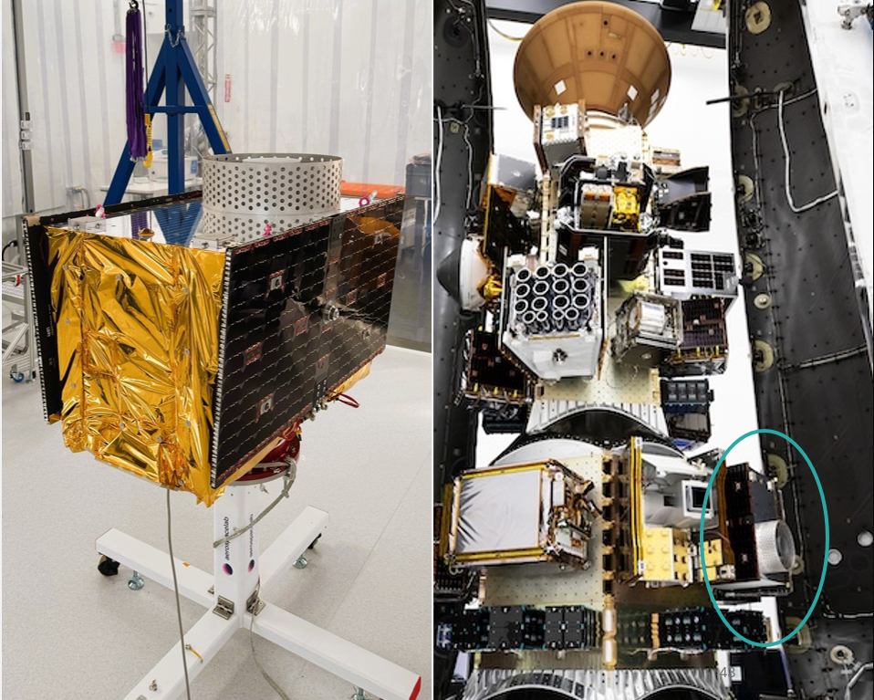
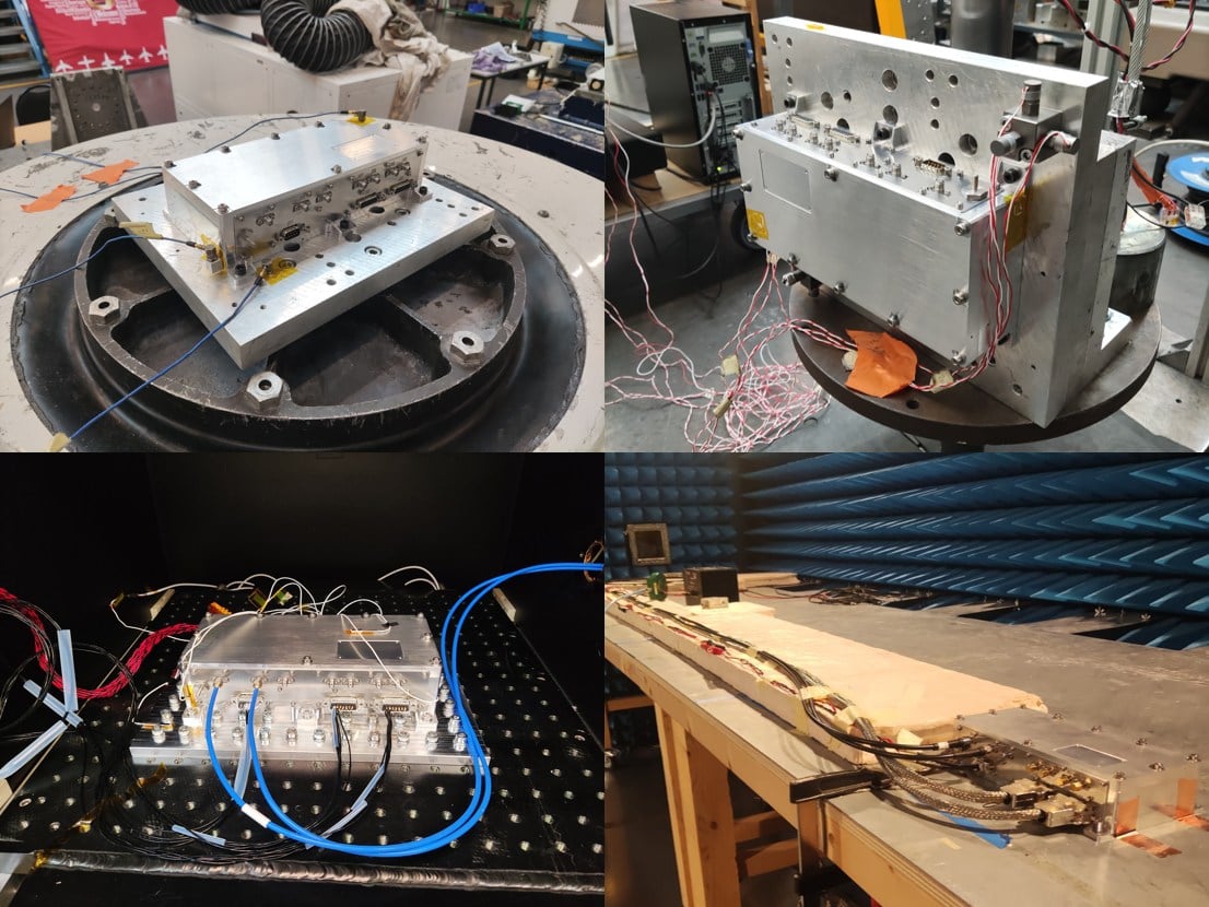
Xona launched its in-orbit-validation stage in June 2025 with Pulsar-0, the first production-class satellite representative of the scaled capability in terms of signal modulation, power and features. Pulsar-0 allowed for performance validation of the complete system, not just of the payload in space but also the tangible benefit to users on the ground. For scale, Figure 4 shows the 150 kg class satellite pre-launch, including its integration on the Falcon 9 launch vehicle. Launch cost has been become more accessible, unlocking the ability to launch larger spacecraft by commercial entities, which can have larger positive impact on the ground (Xona, 2025b).
Figure 4. Xona’s first production satellite Pulsar-0.
LEO PNT on-orbit
In almost 6 months since launch, Pulsar-0 has been tracked in more than 6 countries, 12 third-party receiver protypes, and has achieved several performance milestones that signal the groundbreaking capability Pulsar will deliver to users everywhere when the full constellation is operational. Early performance tests are built to showcase the value and features most important to commercial users in realistic settings.
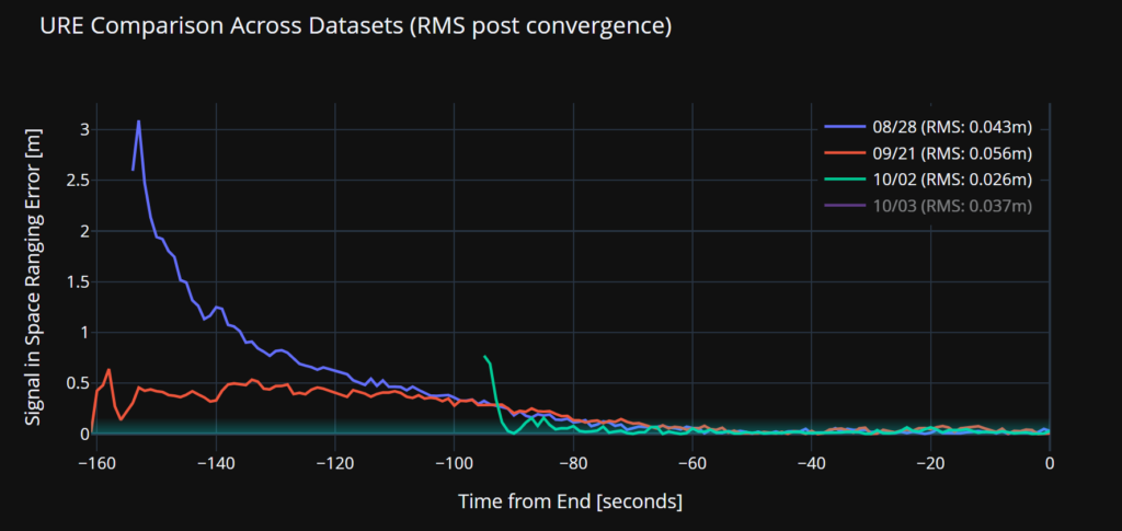
Accuracy. Figure 5 illustrates a signal-in-space user-range-error (SISRE) of 43 mm — about the diameter of a golf ball. This performance represents a more than tenfold increase in accuracy compared to that reported by GPS (Refro et al., 2024). The implication is an ability to natively perform PPP at the centimeter level, without an additional data link or correction layer.
Figure 5. Estimate of SISRE for Pulsar-0 ranging signal compared with nominal GPS.
Security. Xona is the first organization to show pseudorange authentication from orbit, accomplished using the Pulsar-0 satellite within weeks of the launch (Anderson, 2025). Pulsar is built from the ground up to be secure by design, combining cryptographic authentication of both navigation data and satellite ranging signals with rapidly authenticated signal verification — aiming for a time-to-authentication of approximately four seconds. This layered security significantly raises the technical and financial bar for would-be spoofers. A spoofer spoofing a single satellite continuously should succeed in fooling one second of a Pulsar receiver’s ranging once every 130 years (Xona, 2025a).
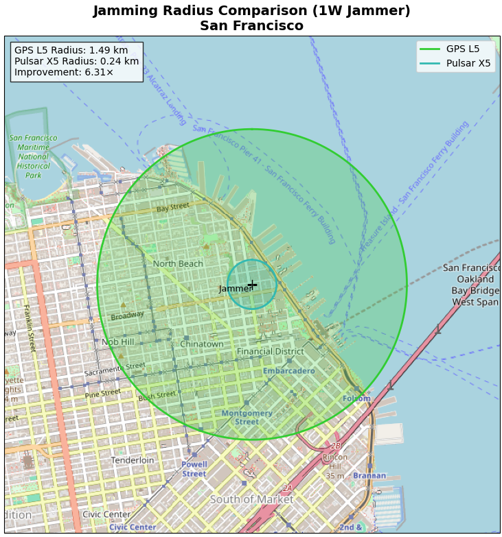
Jamming. Pulsar-0 signal testing has been conducted under live-sky jamming conditions at several jamming events, including Jammertest 2025 in Norway. These campaigns confirmed that using the Pulsar X5 signal can reduce the effective radius of a jammer by 6.3 times as compared to GPS L5 — in other words, less than 3% of the affected area compared to GPS. The same targeted power, bandwidth and type of jammer waveform was used against GPS and Pulsar, including center frequency. For context, Figure 6 shows the implications for a 1 Watt jammer scenario in San Francisco and the reduction brought by a 6.3x reduction in radius.
Figure 6. ffective jamming areas for Pulsar X5 and GPS L5 from a 1 W jammer in San Francisco based on Jammerfest 2025 test results.
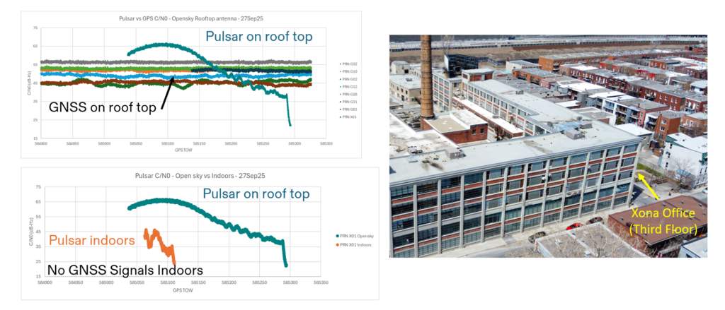
Indoor. Data were collected for several navigation passes per day at multiple locations, including indoors. These include passes at Xona headquarters in Burlingame, California, and its office in Montreal, Canada. The most challenging indoor environment was Montreal, on the third floor of an industrial and primarily concrete building with two floors above. Figure 7 shows the Pulsar-0 power profile during a typical pass, peaking at the highest point in the sky. This structure is an artifact of the antenna gain pattern used in this mission. Designed for a higher altitude for deployment of later satellites, the pattern will be more isotropic with future satellites launched near 1100 km altitude compared to Pulsar-0, which is closer to 500 km. Near apex, the signal penetrates indoors, and this short segment proves to be sufficient for indoor positioning for stationary users. Leveraging techniques based on Doppler and including pseudorange, early results indicate sub-10 meters both outdoors and indoors.
Figure 7. Comparison of Pulsar and GPS signal strengths on roof and indoors at the Xona Montreal office.
EVOLUTIONARY
The coming years will be about gaining operational experience and in scaling the constellation with a near-term focus on the first batch of 16 satellites. Pulsar-0 has already confirmed its value proposition: attaining major milestones in performance including accuracy, security and jamming, but perhaps most importantly in the integration of user equipment. The next year is about working with customers in specific industries and use cases as Xona moves towards deployment of early operational service.
The future of LEO PNT is bright. Theory has evolved to prediction, which is now evolving to reality. The early results appear to lead to an exciting PNT future with LEO PNT expanding the GNSS revolution in terms of security, interference mitigation and system availability both outdoors and indoors for a myriad of current and new applications and users.
Further Reading
Anderson J (2025). World’s First Authenticated Satellite Pseudorange from Orbit, Proceedings of the 38th International Technical Meeting of the Satellite Division of The Institute of Navigation (ION GNSS+ 2025), Baltimore, Maryland, September 2025, pp. 738-748.
Eissfeller B, Pany T, Dötterböck D and Förstner R (2024). A Comparative Study of LEO-PNT Systems and Concepts, Proceedings of the ION 2024 Pacific PNT Meeting, Honolulu, Hawaii, April 2024, pp. 758-782.
Li W, Yang Q, Du X, Li M, Zhao Q, Yang L, Qin Y, Chang C, Wang Y, Qin G (2024). LEO augmented precise point positioning using real observations from two CENTISPACE™ experimental satellites. GPS Solutions, 28(1): 44.
Mah C, O’Keefe K (2025). Hardware Simulation of Low-Earth-Orbit GNSS for Carrier Phase Ambiguity Resolution, Proceedings of the 38th International Technical Meeting of the Satellite Division of The Institute of Navigation (ION GNSS+ 2025), Baltimore, Maryland, September 2025, pp. 2431-2443.
Prol FS, Ferre RM, Saleem Z, Välisuo P, Pinell C, Lohan ES, Elsanhoury M, Elmusrati M, Islam S, Çelikbilek K, Selvan K, Yliaho J, Rutledge K, Ojala A, Ferranti L, Praks J, Bhuiyan MZH, Kaasalainen S and Kuusniemi H (2022). Position, Navigation, and Timing (PNT) Through Low Earth Orbit (LEO) Satellites: A Survey on Current Status, Challenges, and Opportunities, IEEE Access, (10): 83971-84002
Reid TGR, Chan B, Goel A, Gunning K, Manning B, Martin J, Neish A, Perkins A and Tarantino (2020). Satellite Navigation for the Age of Autonomy, 2020 IEEE/ION Position, Location and Navigation Symposium (PLANS), Portland, Oregon, April 2020, pp. 342-352.
Reid TGR, Gala M, Favreau M, Kriezis A, O’Meara M, Pant A, Tarantino P and Youn C (2025). Xona Pulsar Compatibility with GNSS. Proceedings of the 38th International Technical Meeting of the Satellite Division of The Institute of Navigation (ION GNSS+ 2025), Baltimore, Maryland, September 2025, pp. 929-943.
Reid TG, Neish AM, Walter T and Enge PK (2018). Broadband LEO constellations for navigation. NAVIGATION: Journal of the Institute of Navigation, 65(2): 205-20.
SpacePNT SA, a global provider of high-accuracy, radiation-tolerant spaceborne GNSS receiver equipment for missions ranging from Earth to cislunar orbit, has completed extensive qualification testing of its second-generation product, including vibration, shock, thermal vacuum and electromagnetic compatibility tests.
The multi-frequency, multi-GNSS receiver resulted from two European Space Agency (ESA) ARTES Competitive & Growth (C&G) development projects supported by ESA and the Swiss Space Office.
The first project enabled SpacePNT to develop an industrialized second-generation product for large-scale production targeting low-Earth orbit, LEO position-navigation-timing and geostationary orbit telecommunications constellations. The receiver includes a proprietary Precise Orbit Determination algorithm that provides sub-decimeter real-time positioning and timing aboard spacecraft. The company validated the POD algorithm in a hardware-in-the-loop environment and retrofitted it into two first-generation flight models delivered to a customer for satellite integration.
Under the second project, SpacePNT developed a Radiation Hardiness Assurance approach for long-duration missions in harsh radiation environments. ESA’s GENESIS satellite mission, which will operate in a challenging medium Earth orbit environment, will be the first to use this RHA approach. SpacePNT will supply the mission’s GNSS receiver equipment.
Though the second-generation receiver uses largely the same hardware, software and firmware technology as the company’s flight-proven first-generation product, SpacePNT performed a complete qualification campaign to validate design changes.
After passing all qualification and performance tests, SpacePNT will begin manufacturing first flight models of its second-generation products for several customers. The receivers will fly on demanding Earth observation, in-orbit servicing and space exploration missions at altitudes from LEO through medium Earth orbit, geosynchronous transfer orbit, geostationary orbit and lunar distances.
The views expressed herein do not reflect the official opinion of the European Space Agency.
The European Space Agency’s first Scout mission, HydroGNSS, was launched Nov. 28, marking a significant step in advancing global understanding of water availability and the effects of climate change on Earth’s water cycle.
The two twin HydroGNSS satellites were carried into orbit at 19:44 CET aboard a SpaceX Falcon 9 rocket, as part of the Transporter-15 rideshare flight from the Vandenberg Space Force Base in California.
Less than 90 minutes after liftoff, the two satellites separated from the rocket. Then, at 22:45 CET, Surrey Satellite Technology Ltd. (SSTL) in the UK confirmed that they had received signals, indicating that both satellites were safely in orbit around Earth.
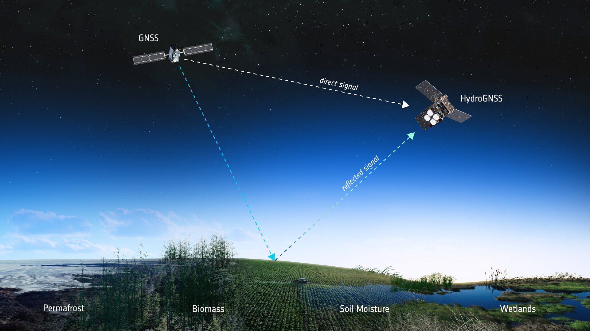
How GNSS reflectometry helps
Both satellites use GNSS reflectometry to scout for water by capturing L-band signals from navigation systems such as GPS and Galileo. These navigation satellites transmit L-band microwave signals that change when they are reflected off Earth’s surface.
The HydroGNSS satellites then compare these reflected signals with the signals the satellites receive directly from the GNSS satellites to reveal valuable information about the properties related to the water cycle, and more.
To do this, each HydroGNSS satellite carries a delay doppler mapping receiver and two antennas. A zenith antenna tracks direct GNSS signals and a nadir antenna collects reflected signals and processes them into delay Doppler maps.
Using this technique, the two small satellites, which orbit Earth 180 degrees apart, will measure soil moisture, freeze-thaw state, inundation and above-ground biomass.
Understanding the water cycle
The data will not only be vital for advancing our understanding of Earth’s water cycle, but also for supporting applications such as flood prediction and agricultural planning.
Also, by observing the extent of inundation and areas of wetland, HydroGNSS will help reveal wetlands – important ecosystems that can act as significant sources of methane – often hidden beneath forest canopies.
Information on freeze–thaw states will provide insight into the surface radiation balance, energy and carbon exchanges with the atmosphere, and the behaviour of subsurface permafrost in high latitudes.
Meanwhile, data on above-ground biomass will contribute to estimates of forest carbon stocks and their role in the global carbon cycle.
More Scouts to come
The Scout satellite missions harness small, smart satellites to shrink proven technologies or test bold new ways of observing the planet. Each mission races from concept to launch in three years, on a lean budget of €35 million that covers everything from design and construction to in-orbit operations.
“As the first of ESA’s Scout missions to launch, HydroGNSS marks an important milestone for this new family of rapid, low-cost Earth observation missions, and we extend our thanks to the mission’s prime contractor, SSTL,” said Simonetta Cheli, ESA’s director of Earth Observation Programmes. “The launch also represents a key step in the evolution of our FutureEO programme, where the Scouts embody a fast, agile, innovative and cost-efficient approach – complementing our larger Earth Explorer research missions.
“We now look forward to seeing how HydroGNSS will employ GNSS reflectometry to deliver valuable insights into key hydrological variables that shape Earth’s water cycle,” Cheli said.
ESA’s prime contractor for the HydroGNSS mission is SSTL in the UK. SSTL is also responsible for operating the satellites in orbit and for distributing the data. The mission is also thanks to partial funding from the UK Space Agency.
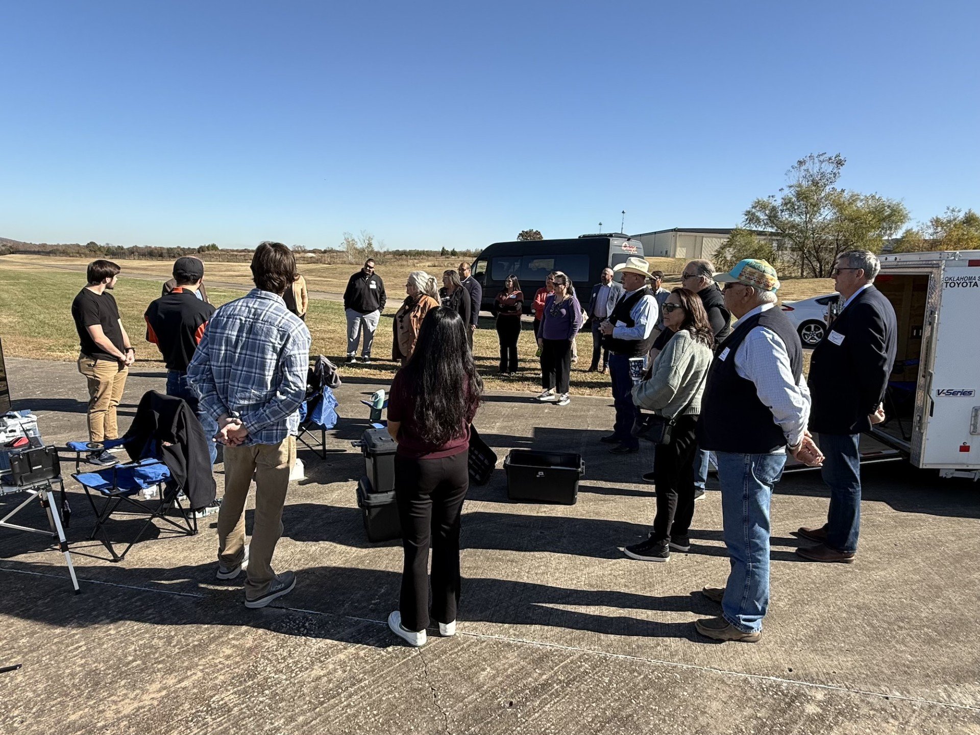
Osage LLC of Oklahoma welcomed members of the Osage Nation Congress for an in-depth tour and lunch briefing at Skyway Range, offering a first look at an ambitious vision to transform the area into a leading center for uncrewed aerial systems (UAS) innovation, testing and economic growth.
The visit provided Osage leaders with a comprehensive overview of current operations and long-term development plans to position the Osage Nation at the forefront of advanced aerospace technologies.
“The tour provided the opportunity to hear and see the potential in Osage LLC’s vision,” said Osage Nation Congressional Speaker Pam Shaw. “I’m looking forward to seeing what is next for Skyway Range. Utilizing this property for the benefit of the Osage people is what it’s all about.”
Photo: Osage LLC
Skyway Range is already a nationally recognized asset due to its expansive Beyond Visual Line of Sight (BVLOS) capabilities, encompassing nearly 1,200 square miles of urban and rural testing environments within 114 nautical miles of airspace. The range’s proximity to Tulsa International Airport’s Class C airspace and its unique blend of terrain make it one of the most flexible and capable UAS test ranges in the United States.
Osage LLC is also part of the Tulsa Regional Advanced Mobility (TRAM) Cluster, a collaboration between public, private, non-profit, tribal and academic partners committed to building a thriving, inclusive advanced mobility ecosystem in northeast Oklahoma. Through this partnership, the region received a Build Back Better Regional Challenge (BBBRC) award from the U.S. Economic Development Administration.
BBBRC investments are helping Osage LLC and partners, such as Oklahoma State University and Tulsa Innovation Labs, expand research and development capacity, build testing infrastructure, develop industrial facilities, strengthen workforce pathways, and support entrepreneurs — laying the foundation for commercial UAS testing, manufacturing, research, office development, and future mixed-use opportunities.
Long-term plans for Skyway Range include:
A phased development strategy beginning with critical infrastructure north of 36th Street in Tulsa.
A new Command Center and enhanced operations hub to support Skyway’s growing commercial testing capabilities.
A 50,000 sq. ft. manufacturing facility designed for UAS assembly, prototyping, and light industrial research.
Infrastructure and signage improvements to increase commercial readiness and operational capacity.
Future expansion opportunities for additional manufacturing, office, and mixed-use facilities tied to customer demand and Nation-driven land-use decisions.
Phase One includes $6 million in capital investments approved by Osage Nation Congress, with anticipated completion of office and small-scale manufacturing components by late 2026 to early 2027.
Osage LLC recently secured its first tenant, Windshape, a Swiss aerospace technology company that specializes in advanced indoor weather simulation and drone performance testing. Windshape held a demonstration for Osage Congressional members and shared how this technology is used globally to validate the safety, reliability, and durability of UAS systems.
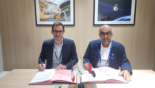
The National Space Science and Technology Center (NSSTC) and Thales Alenia Space, a joint venture between Thales (67%) and Leonardo (33%), are cooperating to explore opportunities in low-Earth orbit (LEO) space navigation systems.
The growing dependence of economies and daily lives on Global Navigation Satellite Systems is driving innovation and leading to technologies that deliver enhanced resilience and improved performance. At the forefront, low-Earth orbit positioning, navigation and timing (PNT) is emerging as a game-changer.
The LEO-PNT satellites seek to provide guaranteed and sovereign centimeter location accuracy, robustness, resistance against jamming and spoofing, and low latency. LEO-PNT will serve emerging applications such as high-level autonomy cars, including persistent coverage in dense urban areas, unmanned aerial and maritime vehicles, and 5G/6G ground telecommunication network synchronization.
Recognizing the strategic importance of LEO-PNT, the NSSTC is working with Thales Alenia Space to explore opportunities in this domain. The partnership was formalized through the signing of a memorandum of understanding at the Paris Air Show 2025, establishing a framework for cooperation. Building on that foundation, both parties signed an agreement marking the start of joint technical studies and engineering activities focused on regulatory protection and system design elements for LEO-PNT.
The collaboration reflects a vision to explore pathways that can enhance the robustness and sovereignty of future navigation services while deepening international cooperation and knowledge exchange between the United Arab Emirates and Europe in the field of space technology.
“This collaboration marks an important step toward building the UAE’s next-generation navigation capabilities,” said Ali Al Shehhi, director of NSSTC. “LEO-PNT will bring a new level of precision and resilience, and working with Thales Alenia Space allows us to accelerate our path toward a sovereign system that supports the UAE’s long-term strategic vision.”
“LEO-PNT is a game changer in satellite navigation in terms of increased precision, resilience and signal penetration, enabling new applications and economic growth,” said Hervé Derrey, CEO of Thales Alenia Space. “We are proud to offer our expertise in satellite navigation to the NSSTC, thereby strengthening our collaboration with the United Arab Emirates in the space domain.”
The challenge of repairing GNSS stations in Bangladesh is recounted in a Nov. 6 article by Mike Steckler, a researcher with Columbia Climate School.
Steckler has been conducting research in the country for 25 years. He previously installed a continuously operating reference station (CORS) network in the southern region of the country.
Data from the network has enabled study of the tectonic motions of the Earth leading up to earthquakes. It also revealed the sinking of the land in the world’s largest delta to less than 1 mm/y.
“I still find that amazing compared to the days before GNSS became routine,” he writes. “I’ve been at sea where the crew had to use sextants to estimate our position to within 10 miles.”
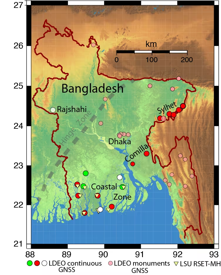
Of 16 stations running in the country, only three (green) were transmitting data back to the U.S. “I have returned here once again with others to get them working again and add three new stations (white),” Steckler writes.
Steckler was joined by a team from Dhaka University to visit the sites, make repairs and install new equipment.
Map of Bangladesh showing the locations of Steckler’s GNSS sites and regions he is visiting. The green circles are working systems, the red ones need repair, and the white ones are new. The pink circles are monuments with no active system. (Image: Mike Steckler)
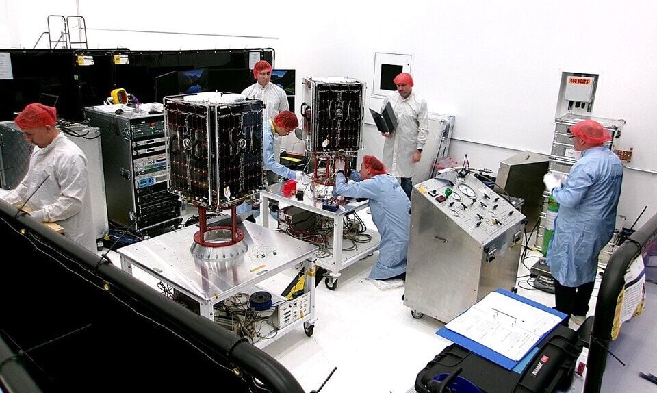
Two European Space Agency (ESA) microsatellites will soon be launched to study climate variables linked to water using GNSS reflectometry. The twin HydroGNSS satellites arrived at Vandenberg Space Force Base in California at the end of September, from where they will be launched later this month.
The HydroGNSS twins are the European Space Agency’s first Scout venture, part of the agency’s Earth Observation FutureEO programme. Scout missions are designed to deliver cutting-edge science quickly and affordably, complementing ESA’s larger Earth Explorer missions.
The identical microsatellites will launch from Vandenberg aboard a SpaceX Falcon 9 rocket, sharing their Transporter-15 ride into orbit with several other small satellites.
Since their arrival, the HydroGNSS satellites have undergone a series of final checks — including testing, propellant loading, battery charging and integration with their launch adapter. Both satellites are now ready for closing of the rocket fairing.
Once in orbit, the two satellites will travel 180 degrees apart around Earth to maximize coverage.
The mission focuses on four crucial variables, all recognized as “essential climate variables” or closely related to them: soil moisture, freeze–thaw state over permafrost, inundation and above-ground biomass. These data are vital for improving our understanding of Earth’s water cycle, including wetlands, permafrost dynamics and forest carbon storage. The data will aid in agricultural planning, flood prediction, and others areas.
HydroGNSS satellites will use GNSS reflectometry to measure key hydrological climate variables, including soil moisture, freeze–thaw state over permafrost, inundation and wetlands, and above-ground biomass. (Image: ESA)
Navigation satellites such as GPS and Galileo transmit L-band microwave signals that change when reflected off Earth’s surface. HydroGNSS will compare these reflected signals with the direct GNSS signals to extract valuable information about geophysical parameters related to the water cycle.
New Space missions. Inspired by the principles of New Space, the Scout programme emphasises agility and innovation — using small satellites to miniaturise proven technologies or demonstrate entirely new ways of observing Earth.
Each Scout mission must move from kick-off to launch within just three years and under a budget of €35 million, covering everything from satellite development to in-orbit commissioning. The resulting data are provided as a service to the scientific community and ESA, helping accelerate our understanding of the planet.
Raytheon UK, part of RTX’s Raytheon business, has been awarded a contract to provide orbital analysts in support of the UK’s Space Domain Awareness mission.
Under the contract, the UK Space Agency will gain access to Raytheon UK’s NORSSTrack software, which enhances orbital analysis and operational responsiveness by mapping and tracking satellites, monitoring potential collisions and debris, assessing re-entries and providing critical data for decision-making.
The analysts will be based at a National Space Operations Centre facility at Royal Air Force Base High Wycombe.
As highlighted in the UK’s Strategic Defence Review, space domain awareness is central to protecting critical space assets and strengthening resilience across government, defense and industry. It is considered a vital national capability, ensuring the UK can operate safely, securely and confidently in an increasingly contested space environment.