Xona has reached three new commercial agreements with precision timing innovators Hoptroff, Fibrolan and Timebeat, marking its official entry into the precision timekeeping and synchronization market. These partnerships seek to enable end users to leverage Xona’s Pulsar satellites to provide independent, secure, and resilient timing infrastructure amid mounting global complexity and risk.
Satellite navigation provides far more than positioning — it’s the world’s most accurate source of globally synchronized time signals underpinning nearly every critical system, including:
Emergency response coordination
Real-time power grid balancing
Transportation network resilience
Fair and trustworthy global financial trading
5G network synchronization
Data center efficiency and security
As infrastructure becomes more connected and distributed, timing is the backbone of data governance— determining who holds critical data, when it was held and for how long. A single second lost or spoofed can erode trust across every facet of daily life.
Broadcasting nanosecond-level accurate time from low-Earth orbit, Pulsar provides a new alternative to vulnerable GNSS-based systems. With built-in authentication, secure signals, and up to 100x received power of legacy GNSS, Pulsar ensures reliable reception even in low-rise buildings and urban environments — all without requiring specialized hardware, according to the company.
“This is an important milestone — proof that next-generation satellite technology is no longer just promising innovation, but solving real, urgent problems today.” said Jay Wakenshaw, COO of Xona. “Seeing market leaders like Hoptroff, Fibrolan, and TimeBeat adopt Pulsar validates that there’s a genuine need and significant demand for what we’re bringing to market.”
Pulsar testing and demonstrations in real-world environments will continue through this year and into early next year, with active field deployments planned from late 2026.
“Our customers in critical national infrastructure rely on precision timing to keep their operations secure, compliant, and efficient.” said Tim Richards, CEO of Hoptroff. “The low-Earth orbit Ssatellite system provided by Xona will add additional redundancy to our global timing network, and complements our existing terrestrial timing infrastructure which is essential for next gen applications particularly in these uncertain times.”
“We’re always seeking innovative alternatives to GNSS — because the future of timing depends on it.” said Shamir Stein, CEO of Fibrolan. “Pulsar is exactly the kind of breakthrough our industry needs: a powerful, dependable solution that will allow us to continue delivering simple, robust, and hassle-free timing to our partners and customers.”
Disclaimer: A previous version of this article contained an error that has since been removed. We strive for accuracy and transparency, and the current version reflects updates correcting this mistake. Please refer to the information below for more current and accurate details on India’s NavIC satellite constellation.
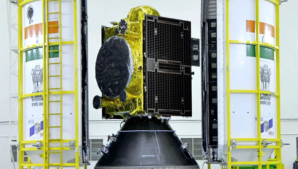
India’s regional satellite navigation system, NavIC (Navigation with Indian Constellation), is facing a severe operational crisis, with only four of its 11 satellites currently operational, according to government data and news reports.
Developed and maintained by the Indian Space Research Organisation (ISRO), NavIC is intended to provide precise positioning, navigation and timing (PNT) services across India and up to 1,500 km beyond its borders. However, this constellation is now on the brink of becoming near-defunct, according to the Indian Defence Research Wing.
Of the four satellites still fully operational, IRNSS-1B has already exceeded its planned 10-year mission life and is at risk of imminent failure. At the same time, IRNSS-1F is also nearing the end of its lifespan with partial equipment failures. IRNSS-1I, launched in 2018, is expected to remain functional until around 2028 but its longevity remains uncertain given the premature failures in the constellation.
The failure of NVS-02 to reach orbit halted progress and highlighted technical challenges that ISRO must address to avoid repeat failures. The Indian government has committed to launching the remaining NVS satellites (NVS-03, NVS-04 and NVS-05) by the end of 2026.
Timely replacement and system upgrades are crucial for maintaining India’s strategic autonomy and meeting the growing demands for accurate, independent navigation services in both civilian and defense applications.
The European Union Agency for the Space Programme (EUSPA) has officially declared its Galileo Open Service Navigation Message Authentication (OSNMA) initial service operational. OSNMA introduces a data authentication mechanism for Galileo Open Service users and is available free of charge to Galileo users worldwide.
Spoofing is the transmission of counterfeit satellite signals that deceive GNSS receivers, causing false, unreliable positioning that can disrupt critical sectors including transportation, finance, telecommunications, energy, manufacturing, healthcare, emergency services and law enforcement. In safety-critical domains such as aviation and maritime, spoofing risks can lead to serious safety hazards.
OSNMA addresses these threats by embedding a cryptographic digital signature within the Galileo navigation message (I/NAV) broadcast on the E1-B signal. This digital signature allows receivers equipped with OSNMA to verify that the signal truly originates from Galileo and has not been tampered with or spoofed.
OSNMA is integrated into the Galileo Open Service signal, which is already used by most GNSS devices. This means no change to existing Galileo signal structure or navigation performance, preserving full backward compatibility. Non-OSNMA receivers continue to function normally, while OSNMA-capable receivers decode and authenticate the digital signature.
The European GNSS Service Centre (GSC), located at the National Institute for Aerospace Technology (INTA) in Torrejón de Ardoz, Spain, manages the generation and transmission of authentication messages to Galileo’s ground segment. The OSNMA service was developed in collaboration with industrial partners, including GMV and INDRA, who also contributed to Galileo’s High Accuracy Service (HAS), operational since January 2023.
Researchers demonstrate a seaplane-type UAV using GNSS-A can precisely measure seafloor deformation
Megathrust earthquakes are large earthquakes that occur on faults found along the boundaries between tectonic plates. The Nankai Trough is a megathrust earthquake zone lying off the southwestern coast of Japan, and experts estimate that this zone could generate a potentially devastating (magnitude 8 or 9) large earthquake sometime in the next 30 years. A seismic event of this magnitude could trigger cascading hazards such as destructive tsunamis.
Developing the technologies for efficient and reliable seafloor monitoring is paramount when considering the potential for socioeconomic harm represented by megathrust earthquakes. Traditionally, seafloor measurements have been obtained using transponder stations on the seafloor that communicate with satellites via buoys or ocean-going vessels to produce accurate positional information. However, data collection using such systems has problems such as low efficiency and speed.
In a study published in Earth and Space Science, researchers at Institute of Industrial Science, the University of Tokyo, addressed the challenge of acquiring reliable, high-precision, real-time seafloor measurements by constructing a seaplane-type unmanned aerial vehicle (UAV) that can withstand ocean currents and wind. This vehicle is intended for use with the GNSS–Acoustic (GNSS-A) ― a system that uses satellites to determine locations on Earth ― to provide a communication link with seafloor transponder stations.
“We conducted initial experiments in a water tank,” explains lead author of the study Yuto Yoshizumi, “and found that the proposed system can detect distances to an accuracy within 2.1 cm.”
To further evaluate the system, at-sea trial tests were performed by landing the UAV on the sea surface off the coast of Japan under optimal sea conditions. “The results were hugely encouraging,” said senior author Yusuke Yokota. “These seafloor positioning measurements are the first ever achieved using a UAV, and we attained a horizontal root mean square error of approximately 1–2 cm, which is easily comparable to that of existing vessel-based systems.”
The rapid real-time acquisition of seafloor information using the UAV system developed by the research team at Institute of Industrial Science, the University of Tokyo, is expected to provide the foundation for advanced research into earthquake disaster prevention. Such data are urgently needed given the speed and frequency of occurrence of megathrust earthquakes on the Nankai Trough.
The rapid growth of satellite constellations in low-Earth orbit (LEO), the risk of orbital collisions is rising at an unprecedented rate. The increasing amount of space debris — ranging from active satellites to defunct assets and debris — poses serious challenges for operators striving to maintain the safety and sustainability of their missions. As daily data volumes grow and conjunction warnings become more frequent, the space community faces pressure to adopt more advanced and reliable collision avoidance solutions.
In response to these growing challenges, the European Space Agency (ESA) has awarded GMV a research and development contract under the ARTES Core Competitiveness program, aimed at improving collision avoidance services for large telecommunications constellations. The initiative will focus on developing advanced capabilities for FOCUSOC NXTGEN, a platform designed to deliver faster and more accurate collision risk assessments by using diverse data sources and enhanced response strategies.
As part of the project, a conjunction assessment center will be established in the United Kingdom to expand support for satellite operators both domestically and internationally. The new system architecture aims to handle higher volumes of data and provide scalable performance to match the needs of next-generation constellations, potentially exceeding 1,000 satellites per constellation.
FOCUSOC NXTGEN incorporates several features, including a dedicated database for trend analysis, a maneuver testing environment grounded in flight dynamics, API integration for efficient operations, and a redundant infrastructure to ensure continuous service availability. The system seeks to filter out false positives from daily orbital data, identify genuine threats more accurately, and deliver timely recommendations to operators for effective maneuver planning.
The service is set for launch in summer 2026 in coordination with industry partners. ESA officials note that enhancing orbital collision avoidance technologies will be crucial to maintaining safe and sustainable operations as satellite numbers continue to rise.
ESA’s ARTES Core Competitiveness program provides funding and expertise to strengthen the satellite communications sector across Europe and Canada. The program supports both technology development and efforts to bring innovative products and services to market.
New multi-orbit space company has network of 120 GEO+MEO satellites and access to LEO constellations.
SES, a space solutions company, has completed its highly value accretive acquisition of Intelsat, creating a strengthened global satellite operator with an expanded fleet of 120 satellites across two orbits. The newly combined company will leverage its skilled teams with deep vertical expertise to deliver integrated multi-orbit, multi-band satellite and connectivity solutions to businesses and governments around the world, creating a stronger multi-orbit operator with ~60% of revenue in high-growth segments.
With a network of approximately 90 geostationary (GEO), nearly 30 medium earth orbit (MEO) satellites, strategic access to low-Earth-orbit (LEO) satellites, and an extensive ground network, SES can now deliver connectivity solutions utilizing complementary spectrum bands including C-, Ku-, Ka-, Military Ka-, X-band and Ultra High Frequency. The expanded capabilities of the combined company will enable it to deliver premium-quality services and tailored solutions to its customers. The company’s assets and networks, once fully integrated, will put SES in a strong competitive position to better serve the evolving needs of its customers including governments, aviation, maritime and media across the globe.
Adel Al-Saleh, CEO of SES, talks about the new combined company in the video below.
The transaction establishes a more robust financial foundation for SES, with pro formacombined revenue of €3.7 billion projected to grow at a low- to mid-single digit CAGR (2024-2028E). The combined company pro forma Adjusted EBITDA of €1.8 billion is expected to grow at mid-single digit CAGR including synergies (2024-2028E), with plans to generate over €1 billion in Adjusted Free Cash Flow by 2027-2028 (pre IRIS2). This stronger financial profile is supported by a combined contract backlog exceeding €8 billion, providing clear visibility into future revenue streams.
SES plans to maintain disciplined investment in future growth, with annual capital expenditures averaging €600–€650 million from 2025-2028E, excluding the IRIS2 programme. This will enable the company to continuously strengthen its network and explore emerging growthmarkets including Internet of Things (IoT), direct-to-device communications, inter-satellite data relay, space situational awareness, and quantum key distribution. The company’s profitable growth outlook, strong balance sheet metrics and expanded cash flows will support both continued innovation and increased shareholder returns, with the intent to raise the annual base dividend once targeted net leverage of below three times is achieved within 12-18 months after closing.
By integrating the two organizations, SES expects to deliver synergies with a total net present value of €2.4 billion, representing an annual run rate of approximately €370 million, with 70% of these efficiencies anticipated to be executed within three years after closing. These savings will primarily come from streamlined operations, optimised capacity costs, and procurement efficiencies, along with the strategic integration of satellite fleets and ground infrastructure.
SES remains headquartered in Luxembourg and is publicly listed on the Paris and Luxembourg stock exchanges (Ticker: SESG), while maintaining a significant presence in the United States with its North American main office in McLean, Virginia.
Alpha Unmanned Systems (Alpha) in Madrid, Spain, has been developing and building helicopter UAVs for 10 years and has successfully employed them with defense departments in 10 countries. Its UAVs are ruggedized and qualified for the harsh conditions encountered at sea. The fully autonomous A800 and more recent A900 model UAVs have been used in military applications such as border patrol, situation awareness, intelligence gathering, coast guard support and aerial helicopter target simulation. Commercial applications include fishing fleets and oil rig support.
Alpha A900 approaches for deck landing. (Credit: Alpha)
The helicopter UAVs are equipped with a GNSS/MEMS autopilot system that maintains navigation if GNSS is jammed. MEMS sensors, however, can experience significant drift over time. The Alpha model offers two additional backup solutions. With an advanced air data system and pitot sensors, the aircraft can estimate airspeed and wind velocity to help maintain its flight path. If attitude estimation degrades further, remote pilot judgment may be required to recover control. For ground operations, a visual navigation system with a downward-looking camera can record terrain during overflights, building a database that enables navigation in GNSS-denied environments.
One of the newer capabilities Alpha has added includes an Automatic Identification System (AIS) receiver. AIS is a primary radar transponder system used by ships around the world to provide each other with tracking information on other ships that are within about a 30-mile range. With an AIS receiver onboard the UAS surveillance helicopter, ships that are out of visual range, maybe out close to the horizon, now become trackable.
Alpha is a small company that has been in operation since 2014, and it is one of the first to design helicopter UAVs for rough weather and at-sea environments. It’s good to see a focused, supportive outfit gradually succeed, not only with European defense organizations, but also in the U.S. and around the world.
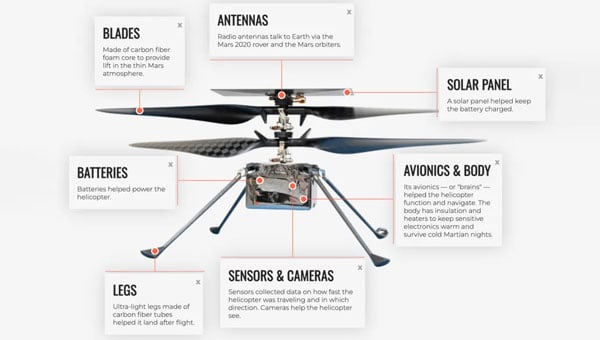
Meanwhile, in a universe that’s not far, far away — in fact, in our solar system — plans are moving forward at NASA to visit Titan with a UAV. Titan is a moon of Saturn that is most favored to have the capability to start, and maybe support, life. Numerous organic compounds have been detected during earlier satellite visits. But this is no ordinary UAV, quite unlike Ingenuity, the solar-powered hopper that NASA flew 72 times on Mars.
Ingenuity, a UAV that flew 72 times on Mars. (Credit: NASA)
NASA’s Ingenuity helicopter, which traveled to Mars attached to the Perseverance rover, was designed to demonstrate powered flight in the Red Planet’s thin atmosphere. Ingenuity featured oversized rotor blades to generate enough lift and was built to be as lightweight as possible. Its only equipment was a camera and speed sensors, with no scientific instruments aboard.
The helicopter performed flights over Jezero Crater, ultimately spending about 130 minutes aloft and covering 11 miles during 72 flights. Ingenuity’s mission came to an end after it sustained damage to a rotor during a hard landing, grounding the aircraft and concluding its operations on Mars.
The next interplanetary unmanned flying system is significantly more complex, replacing the lander and drone approach used on the Red Planet with a complete vehicle capable of flying and conducting the necessary investigative science. With a budget of $3.35 billion, NASA’s work has been underway since 2024, led by John Hopkins Applied Physics Lab, and a host of main and supporting organizations, including Lockheed Martin Space, Malin Space Science Systems (cameras), Honeybee Robotics (Blue Origin subsidiary, moon lander development) and participation by agencies in France, Germany and Japan. While Ingenuity was developed and built by UAV manufacturer AeroVironment with management/support from NASA/Jet Propulsion Labs (JPL), the team for Dragonfly appears to have a few industrial partners and extensive government support – hopefully, this works out!
Powered by a Radioisotope Thermoelectric Generator (RTG), Dragonfly has four sets of double rotors, landing skids, and, of course, has to be fully autonomous – the radio transit time between Titan and Earth is between 1 hour 10 minutes and 1 hour 40 minutes. Titan’s night is eight Earth days long, so the idea is to fly during the day (throughout 15 Earth days), then land and recharge batteries, and receive NASA’s instructions for the following day’s activities during the long night. The atmosphere is thought to be substantially composed of nitrogen and methane, four times thicker than Earth’s, and gravity is about 1/7, so 4 ft props with enough lift and power could carry the 880 lb to 990 lb UAV up to 10 miles for each flight at altitudes of up to 12,000 ft. But when observing and imaging the terrain, we might guess it would probably mean mostly low-level flights.
Dragonfly Titan UAV explorer (Credit: NASA/Johns Hopkins APL/Steve Gribben)
At this weight, we are looking at something quite substantial to be flying around the anticipated sand dunes and frozen methane surface of Titan. Autonomous operations will need to be tight and safe for this big vehicle to operate and survive; it’s not exactly a small car, but quite substantial. Not to mention that landing will need to be somewhat delicate to protect the sensitive onboard instrumentation.
A spacecraft is scheduled to launch aboard a SpaceX Falcon Heavy in 2028, embarking on a complex journey that includes a flyby of Venus and a gravity-assist maneuver past Earth to set a direct course for Saturn’s moon Titan. The probe is set to enter Titan’s dense atmosphere directly, protected by a heat shield. After initial deceleration from atmospheric drag, two drogue parachutes will deploy, followed by a powered descent to the equatorial region known as the Shangri-La dune fields.
The voyage is expected to take six years, with arrival at Titan in 2038. Once on the surface, the Dragonfly mission will begin a 2.7-year exploration of the moon.
An interesting initial glimpse into a future, really advanced drone are undertaking. Hopefully, NASA will keep to its schedule, the budget holds up, and we start to see hardware in the next few years. Meanwhile, Alpha could be on version 16 of its UAV helicopter by then and achieve massive success with its multi-mission UAV applications.
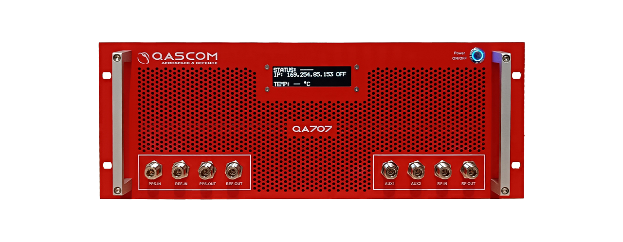
Qascom S.R.L. (IT) has successfully delivered the final presentation of the NAVISP-EL2-081 – MOOD (Moon testbed) project, marking the culmination of a multi-year effort to develop a cutting-edge GNSS simulation testbed for lunar, cislunar and space-based PNT applications.
For this purpose, Qascom upgraded its QA707 GNSS simulator introducing advanced features such as lunar-specific ranging strategies, support for multiple coordinate reference systems, custom signal transmitters (including LunaNet AFS), and a 3D Viewer for real-time scenario visualization. It also integrates BeiDou B1C signal simulation and dual-frequency RF streaming capabilities.
Key achievements include successful validation of LunaNet and BeiDou signals, implementation of Moon Principal Axis (Moon-PA) ranging, and integration with open-source and COTS receivers. The simulator has already supported the project NAVISP-EL1-062 – DEMOS-1(Lunar Surface PNT Beacon Demonstrator) and is now Qascom’s flagship GNSS simulation product.
The project was supported through NAVISP Element 2 for PNT competitiveness for European industry. The slides of this final presentation can be found here.
The U.S. Space Force’s Space Operations Command has accepted a modernized operating system for GPS, designed to maintain the resiliency of the constellation and enhance positioning, navigation and timing (PNT) services to meet evolving user demands.
The GPS Next Generation Operational Control System (OCX) upgrade is part of a broader set of Space Systems Command acquisition programs designed to deliver a range of modernized capabilities across the GPS III enterprise. In addition to OCX, these programs include the GPS III/IIIF satellite vehicles and Military GPS User Equipment.
The modernization effort is expected to improve signal access in electronically contested environments, increase the system’s ability to detect failures, enhance position and time transfer accuracy, and strengthen the integrity and uninterrupted availability of the Military Code.
“One of our missions is to deliver sustained, reliable GPS capabilities to America’s warfighters, our allies, and civilian users,” said Cordell DeLaPena, program executive officer for military communications and PNT at Space Systems Command. “The current enterprise modernization efforts underway give users confidence that GPS will continue to provide worldwide premier PNT service.”
Mission Delta 31, in partnership with Space Systems Command, developed a systematic process involving transition exercises, rehearsals and constellation transfer trials to verify the system’s integrity and capability prior to full transfer, according to Col. Stephen Hobbs, commander of Mission Delta 31. Hobbs added that risk reduction activities are underway to demonstrate OCX’s ability to integrate with existing, on-orbit GPS satellites.
Raytheon initiated the delivery of OCX to the U.S. government with the submission of the Department of Defense Form 250 on July 1, 2025. Following acceptance, Mission Delta 31 will continue integrated systems testing, operational readiness exercises and preparations for the eventual transfer of the GPS constellation to the new system.
“Testing and transition events will continue until the system is ready to transfer to operations, which is expected in late 2025,” said Hobbs. “Technology in space is advancing at lightning speed, with many new players from around the world. To continue providing reliable GPS for everyone, from your smartphone map to critical military operations, innovation is vital. Modernizing GPS is key in maintaining this essential service and remaining a leader in Space.”
Neuraspace is working with the European Space Agency (ESA) to use innovative GNSS technologies to minimize signal noise under a new NAVISP project. Neuraspace is an expert in space domain awareness (SDA) solutions,
“Stop Getting Noise – Automated GNSS Processing for Smarter Orbits” (NAVISP Element 2) seeks to address critical operational challenges faced by commercial satellite operators, launch service providers and defense and government agencies.
Challenges to be addressed include the urgent need for more scalable, accurate and autonomous orbit determination, particularly for satellite mega-constellations, in an increasingly congested space environment. While defense and government agencies demand high-confidence SDA solutions amid increasing geopolitical tensions, satellite operators require reliable orbit tracking and early mission support.
The result is expected to use innovative GNSS technologies to reduce the risk of satellite collisions and enable satellite operators to make faster and more accurate decisions about safekeeping their assets. Solutions will also lead to more efficient operations with lesser reliance on ground infrastructure and smarter fuel management translating into lower mission costs.
In particular, the project includes:
GNSS Data Cleanup to remove biases and noise to improve the precision of orbit determination.
GNSS Orbital Phase Correction by introducing lightweight onboard algorithms designed to run on resource-constrained satellite systems. The algorithms will use real-time data to enable satellites to autonomously correct trajectory predictions and minimize reliance on ground stations, saving time and resources.
GNSS Orbit Determination Accuracy to provide better orbit predictions by developing advanced methodologies to deliver critical positioning information for safe operations and maneuver planning.
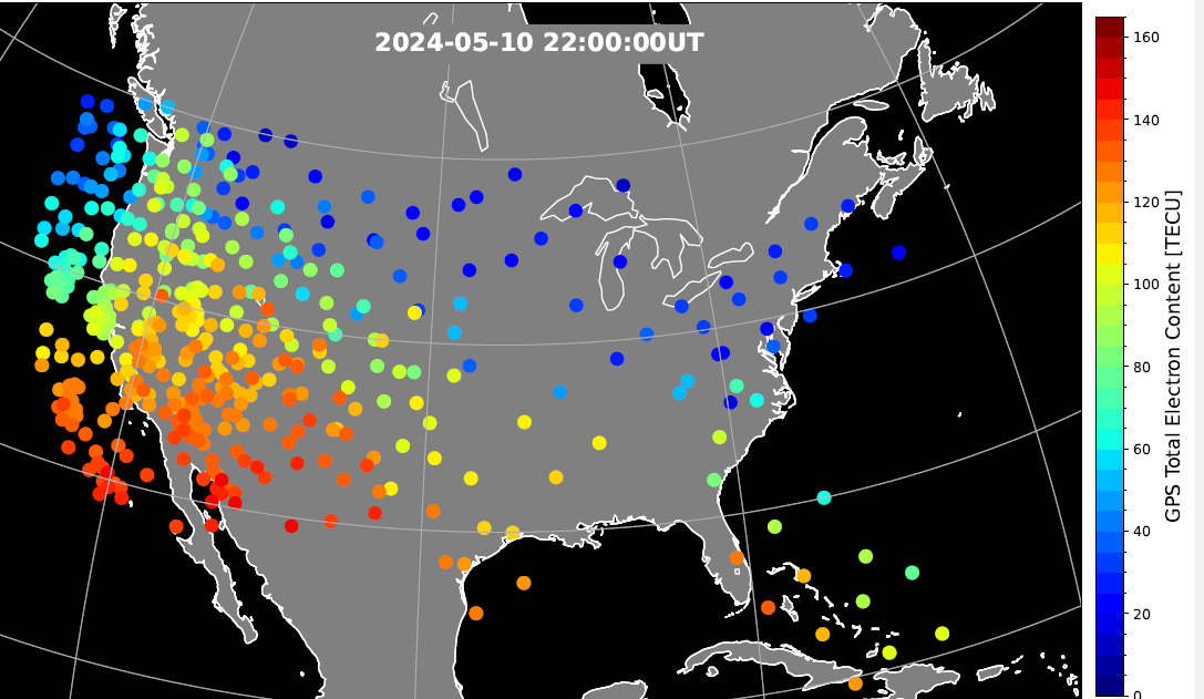
During the geomagnetic storm that took place May 10–11, 2024, GPS users reported significant positioning errors and outages. In particular, farmers in the Central United States reported difficulty in getting a fix with their tractors and other farm equipment.
Also affected, to a lesser extent, was the Southwestern United States.
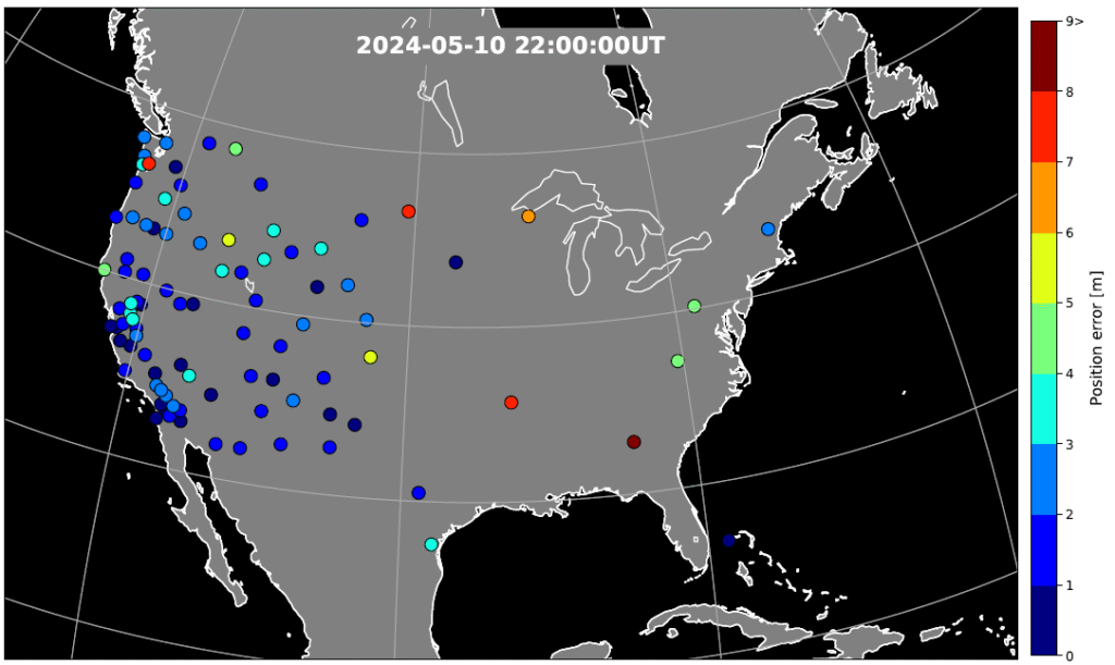
A new study has identified the cause of the GPS outages by analyzing the data from a 1‐Hz GPS receiver network. Standalone GPS position errors In precise point positioning (PPP) mode in the Central United States reached 70 meters on May 10. The errors were attributed to a steep wall in ionospheric plasma that rapidly moved southward.
In the soutwestern states, the GPS position errors were elevated 10 to 20 meters because of the enhanced plasma density.
Vertical protection level as provided by WAAS.
Then, on May 11, intense auroral activity caused rapid enhancements in the ionospheric plasma, leading to abrupt position errors of 10 meters. Network‐based position systems likely encountered even longer duration of position errors because these ionospheric disturbances are localized.
“These findings highlight the need for more accurate understanding of ionospheric plasma conditions, as well as software and hardware improvements, to reduce disruptions during space weather events,” report the authors of “Spatio‐Temporal Evolution of Mid‐Latitude GPS Scintillation and Position Errors During the May 2024 Solar Storm.” Authors are Waqar Younas, Yukitoshi Nishimura , Weixuan Liao , Josh L. Semeter, Sebastijan Mrak, Jade Morton and Keith M. Groves. The full report will appear in an upcoming issue of the Journal of Geophysical Research: Space Physics and is now available on ResearchGate.
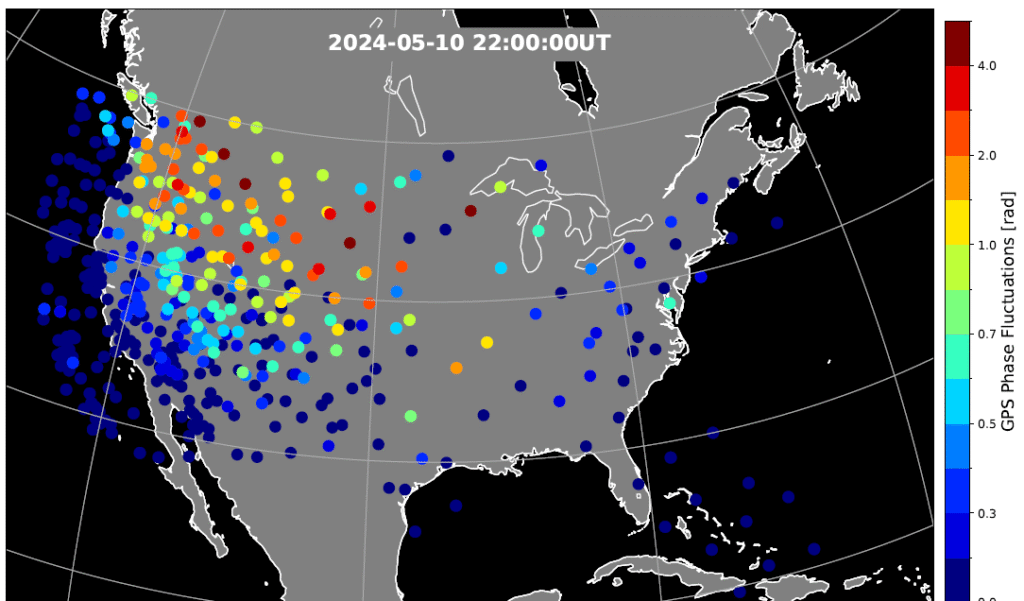
Figure 2. Phase scintillation index over the United States during the geomagnetic storm at 22:00 UT on May 10, 2024. The map is derived from the Global Positioning System (GPS) signals. The map shows enhanced phase fluctuations that impacted GPS position accuracy. Adapted from Figure 4d of the paper. (Credit: Authors)
Key Points
PPP failed to converge in the SED and trough, while PPK became unstable after CME arrival until the recovery phase.
SED, EIA, and trough created position errors on the noon‐evening sector. Substorms caused position errors on the nightside.
Scintillation, cycle slips, satellite geometry and ray bending were identified as contributing factors to the large position errors.
Figure 3. GPS position error over the United States during the geomagnetic storm at 22:00 UT on May 10, 2024. The map is derived from the Global Positioning System (GPS) signals. The map shows large error occurs at trough boundary and enhanced TEC regions. Adapted from Figure 5d of the paper. (Credit: Authors)
The study investigates impacts of the May 2024 superstorm on the mid‐latitude GPS scintillation and position errors. Using 1‐Hz GPS receiver data, the research team identified position errors in PPP mode reaching up to 70 m in the Central United States during the storm main phase on May 10.
The PPK solution becomes unstable following the arrival of storm and lasted till the recovery phase, coinciding with reported GPS outages of farming equipment. The large position errors were attributed to strong scintillation and carrier phase cycle slips around the equator-ward boundary of the ionosphere trough, where large total electron content (TEC) gradients and irregularities were present.
In the Southwestern United States, position errors of 10–20 m were associated with the storm‐enhanced density and equatorial ionization anomaly. Scintillation and cycle slips in this region were minor, and bending of the GPS signal paths (refractive effect) is the probable cause of the position errors. PPP outages were also associated with sudden changes in the geometric distributions of available GPS satellites used in position calculations.
On May 11, energetic particle precipitation during substorms led to abrupt jumps in TEC and scintillation, resulting in rapidly evolving position errors of up to 10 m. These findings highlight the critical role of storm‐time plasma transport, precipitation and irregularity formation in degrading GPS performance.
“The study underscores the need for accurate ionospheric state specification, improved signal processing technique, real‐time ionospheric corrections, and optimized satellite selection algorithms to enhance navigation resilience during severe space weather events,” the authors conclude.
“Seen & Heard” is a monthly feature of GPS World magazine, traveling the world to capture interesting and unusual news stories involving the GNSS/PNT industry.
West Point Cadets Map Electronic Warfare West Point cadets conducted a senior thesis project investigating the use of GNSS technology to map and visualize electronic warfare activities in the South Pacific, specifically focusing on GNSS spoofing. Their research, centered on the Huangpu River and Northeastern Shanghai, aimed to identify patterns of malicious GNSS interference and potential perpetrators, highlighting the strategic and economic motivations behind these actions in the region. By developing data visualizations of spoofing incidents, the cadets created a model that could be scaled up to analyze larger areas.
Credit: Eric S. Bartelt / USMA PAO-VI
South Africa Rising Above Water Researchers from the University of Bonn have found that South Africa’s land is rising by up to 2 mm per year, not because of deep mantle activity, but due to water loss from severe droughts. This uplift was detected using the TrigNet network of GNSS stations, which precisely measures changes in land elevation. As groundwater is depleted, the Earth’s crust rebounds upward — a process GNSS stations can monitor in real time.
Credit: THEGIFT777 / E+ / Getty Images
Türkiye to Launch Homegrown Satellite Navigation and Mapping System Türkiye is developing the Regional Positioning and Timing System (BKZS) to launch its own GPS and mapping application, in an effort to reduce dependence on foreign technology and enhance cybersecurity amid growing industrial automation. The system will provide precise location, navigation and timing data via Turkish satellites as an alternative to global systems including GPS, supporting critical sectors such as military operations, civilian communications, smart transportation, and precision agriculture.
Quantum Navigation System Serves as GPS Backup Q-CTRL, a quantum infrastructure software company based in Sydney, Australia, has demonstrated a new quantum navigation system, Ironstone Opal, as a backup to GPS technology. The Ironstone Opal system uses quantum sensors to detect variations in the Earth’s magnetic field, determining precise geographic coordinates with the help of artificial intelligence-based software. Ironstone Opal is passive and does not emit signals, making it resistant to detection and jamming. Field trials showed the system outperformed a high-end inertial navigation system and served as a reliable GPS backup by up to 50 times in ground vehicles and 11 times in aircraft.