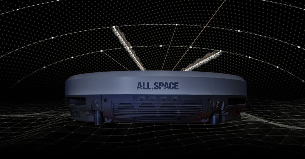
All.Space, a provider of multi-orbit, multi-link satcom omplatforms, has been awarded €950,000 by the European Space Agency’s Navigation Innovation and Support Programme (NAVISP). The award is to develop an alternative position, navigation and timing (PNT) capability designed to operate in GNSS-denied environments.
The project will build a proof of concept for alternative PNT, harnessing All.Space’s multi-orbit terminal technology to generate and analyze signals of opportunity that can deliver position and orientation data independently from traditional GNSS sources.
The technology is designed to counter rising threats from GNSS jamming and spoofing – scenarios of increasing concern for both defence and commercial operators. Delivered in partnership with UK-based GNSS experts GMV NSL, the project is aimed at embedding a resilient PNT capability directly within the All.Space terminal, forming part of its growing software as a service (SaaS) portfolio.
“GNSS denial is no longer a hypothetical scenario,” said Paul McCarter, CEO at All.Space. “It’s a growing reality. With this project we’re developing a sovereign alternative that can restore confidence, capability and control in even the most contested environments.”
Once proven, the technology will be matured and commercialized as an integrated service offering, helping customers achieve operational independence and secure navigation in any domain.
ESA’s NAVISP programme is designed to spur innovation in navigation technologies and services across its Member States.
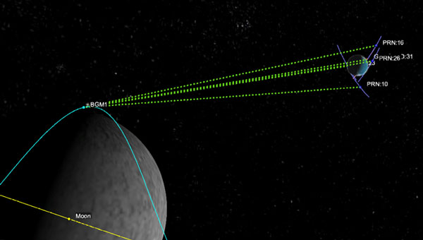
During a public workshop at the Italian Space Agency on Oct. 14-15, the Lunar GNSS Receiver Experiment (LuGRE) project team celebrated the closure of the project and released the data collected to the scientific community.
LuGRE, developed in partnership by NASA and the Italian Space Agency (ASI), flew to the Moon a GNSS receiver manufactured by the Italian company Qascom. The receiver was hosted aboard the Firefly BGM1 mission.
LuGRE demonstrated that signals from GNSS satellite constellations can also be used for positioning, navigation and timing (PNT) on the Moon.
The Navigation Signal Analysis and Simulation of the Dept. of Electroncis and Telecommunications of Polytechnic University of Turin processed the data received during the mission and contributed to all the science team activities, including the validation of the data and the processing of the initial set of scientific results.
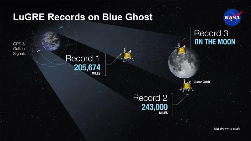
An artist’s concept of the LuGRE payload on Blue Ghost and its three main records in transit to the Moon, in lunar orbit and on the Moon’s surface. (Image: NASA/Dave Ryan)
Launched on Firefly Aerospace’s Blue Ghost lander in January, LuGRE became the first payload to use Earth’s GNSS to calculate a navigation fix on the lunar surface and in lunar orbit. The experiment set a series of distance records on its journey to the Moon, demonstrating that GNSS technology can complement other navigation tools as far as 247,520 miles (398,350 km) from Earth.
These results point to a future where lunar astronauts, rovers and spacecraft can rely on the same satellite-based navigation systems we use every day to augment their navigation capabilities.
“It is a very important milestone for the satellite navigation community,” said Fabio Dovis, Politecnico di Torino, Italian Space Agency, of the project. “For the first time we have the recording of signal of the GPS and Galileo constellation collected in space and on the Moon surface. Already during the LuGRE mission we proved the feasibility of using satellite systems originally designed to be used on Earth up to lunar distances. Now the entire scientific community can use them to ‘re-play’ the space environment as well as analyze them in depth, for example, to retrieve information about the Earth atmosphere crossed by the signal themselves.”
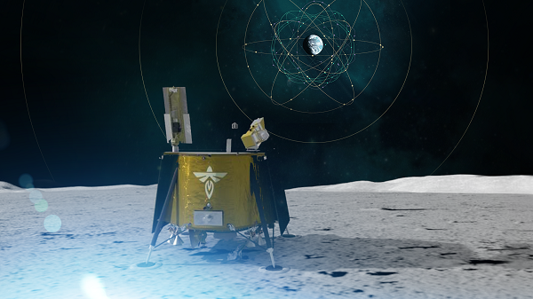
Artistic rendering of LuGRE and the GNSS constellations. In reality, the Earth-based GNSS constellations take up less than 10 degrees in the sky, as seen from the Moon. (Image: NASA/Dave Ryan)
The data release includes the actual GPS and Galileo radio signals LuGRE captured during its journey and on the lunar surface. The raw recordings — called in-phase and quadrature (I/Q) samples — allow researchers to analyze GNSS signal strength, noise and interference under lunar conditions for the first time. Engineers and scientists will use these results to model and refine the next generation of GNSS-based signal receivers and improve our understanding of how navigation signals operate at the Moon.
Graphic representation of the relative geometry of Earth-Moon-acquired GNSS satellites. (Image: Agenzia Sapaziale Italiana)
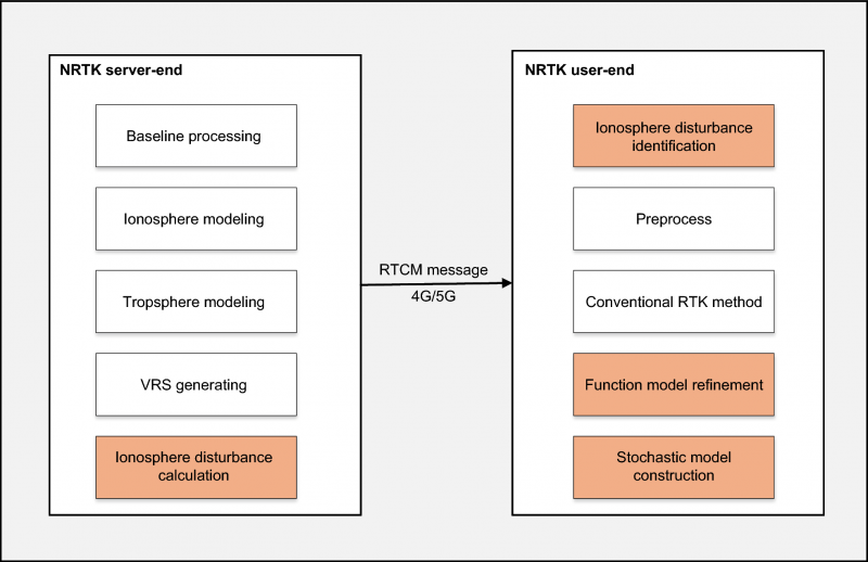
For users relying on centimeter-level accuracy — such as surveyors, engineers and autonomous systems — ionospheric disturbances can mean system downtime and significant losses. Traditional network real-time kinematic (NRTK) positioning methods assume smooth ionospheric conditions and thus fail during active solar periods.
To meet these challenges, a research team from Wuhan University and Guangzhou Hi-Target Navigation Tech Co. Ltd. developed an NRTK positioning model capable of maintaining centimeter-level accuracy under intense ionospheric disturbances.
This approach could serve as the foundation for next-generation, self-correcting navigation systems that operate reliably under any atmospheric condition.
The study (DOI: 10.1186/s43020-025-00179-4), published in Satellite Navigation on Oct. 6, introduces a dual-optimization framework that integrates real-time ionospheric indices with adaptive functional and stochastic models. By learning from disturbance patterns and automatically recalibrating user-side algorithms, the system dramatically enhances GNSS reliability during the ongoing solar cycle peak — offering a key safeguard for positioning technologies in low-latitude regions most vulnerable to ionospheric turbulence.
The innovation centers on leveraging the rate of the total electron content index (ROTI), a key indicator of ionospheric activity, to dynamically adjust both ionospheric residual estimation and observation weighting. When the system detects disturbances, it automatically reduces the influence of affected satellites and refines error models in real time.
Using data from Hong Kong’s Continuously Operating Reference Station (CORS) network — one of Asia’s most active low-latitude regions — the researchers found that ROTI showed a strong positive correlation (0.91) with ionospheric interpolation errors and a negative correlation (–0.9) with signal-fixing rates.
Compared to conventional NRTK methods, their adaptive “Method B” improved horizontal and vertical positioning accuracy by 37.6% and 41.6%, respectively. Moreover, it achieved a stable 84% average fixing rate, even during equinoctial months when ionospheric scintillation is strongest. The results reveal not just a technical upgrade but a practical solution for real-time navigation across regions frequently affected by solar-induced ionospheric noise.
“Our method essentially teaches GNSS systems to think smarter under stress,” said Xiaodong Ren, senior researcher at Wuhan University and lead author of the study. “By allowing the model to ‘sense’ and adapt to space-weather disturbances in real time, we’ve moved beyond static correction systems toward intelligent positioning. This is crucial not only for maintaining accuracy but also for ensuring resilience as solar activity intensifies.”
He added that this approach could serve as the foundation for next-generation, self-correcting navigation systems that operate reliably under any atmospheric condition.
This adaptive NRTK framework marks a significant leap forward for industries that depend on precise, real-time location data — from autonomous driving and drone surveying to precision agriculture and infrastructure monitoring, Ren said. By integrating live ionospheric monitoring into everyday positioning workflows, it ensures continuous accuracy even when solar storms strike.
Future developments may combine the model with artificial intelligence and multi-constellation GNSS networks to further enhance forecasting and resilience. As Earth moves through one of its most active solar cycles, Ren said, such innovations will be essential to keeping navigation, communication and automation systems firmly on course.
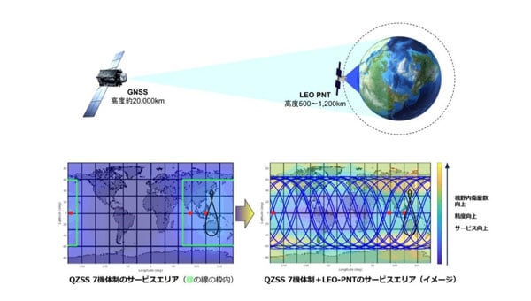
Japan Aerospace Exploration Agency (JAXA) has selected ArkEdge Space to develop a satellite positioning system designed to complement existing GNSS.
The company signed a contract begin the “Study of Elemental Technologies and Related Systems for Low-Earth Orbit Positioning Satellite Systems,” (Dedicated LEO-PNT). ArcEdge Space, led by CEO Takayoshi Fukuyo, provides solutions for microsatellite constellation planning, design, mass production and operation.
The LEO-PNT satellite system uses small satellites orbiting at altitudes between 500 km and 1,200 km to provide high-intensity, high-precision positioning information globally. Traditional GNSS satellites orbit at approximately 20,000 km.
Conventional GNSS technology faces growing threats from jamming and spoofing attacks because weak signals reach Earth’s surface. The LEO-PNT system’s high-intensity positioning signals seek to address these vulnerabilities.
The project builds on JAXA’s feasibility study conducted from October 2024 to March 2025. Researchers will examine technologies and systems for providing robust position and time information to ground users as an alternative to GNSS.
The system’s main feature is GNSS-independent service that can operate when existing systems are disrupted or jammed. Engineers will study transmitting LEO-PNT signals across C, S and L frequency bands, including C1 band (5010-5030 MHz) and C2-4 band (5030-5250 MHz).
Project Details
The study runs from September 2025 to March 2026 and includes signal design, reception technology research and system studies for GNSS-independent LEO-PNT systems.
Key Advantages
High intensity: Lower orbital altitude enables stronger positioning signals that resist attenuation and interference.
High precision: Rapid changes in satellite line-of-sight vectors allow faster positioning convergence, supporting applications like autonomous driving and precision agriculture.
Global coverage: Satellites in LEO can extend services currently limited to QZSS coverage, such as MADOCA-PPP.
ArkEdge Space said the technology will contribute to highly automated societies and a safer future.
Septentrio and xonaspace.com have signed a Memorandum of Understanding (MOU) to deepen their collaboration on next-generation positioning and timing solutions.
The agreement builds on Xona’s recent successful launch of Pulsar-0, its first production class LEO PNT satellite. Within days of launch, Septentrio began tracking and analyzing Pulsar signals, an early milestone toward unlocking the service’s full potential.
Together, the companies will continue joint testing and validation to prove Pulsar’s full capabilities, including: • native centimeter-level accuracy • 100x stronger signal strength that reaches indoors and under dense foliage • robust protection against jamming and spoofing.
Through this partnership, Septentrio and Xona will advance receiver development, evaluate real-world performance, and explore commercial opportunities across diverse set of industrial and defense applications. Potential use cases span drones and autonomous vehicles, precision agriculture, construction and mining, robotics, timing and critical infrastructure.
This collaboration marks a significant step toward addressing the growing demand for robust, high-precision navigation in challenging environments. The MOU underscores a shared vision of both companies to advance satellite-based navigation technology and unlock the potential of hybrid GNSS-LEO solutions.
PlanetiQ, a provider of commercial weather and space weather data, has been awarded a $24.3 million contract from NOAA’s National Environmental Satellite, Data, and Information Service (NESDIS). The award, issued under the Commercial Data Program’s Radio Occultation Data Buy 2 (RODB-2), is NOAA’s single largest commercial satellite weather data purchase.
Under the agreement, PlanetiQ will deliver 7,000 GNSS-RO profiles per day, including 500 enhanced high-signal-to-noise ratio (SNR) profiles as well as 2,500 low-latency Total Electron Content (TEC) tracks daily. Data deliveries began Sept. 18.
“I founded PlanetiQ because radio occultation is one of the few technologies I’ve worked with that tangibly improves the human condition. It’s gratifying to see this capability recognized and scaled.”
GNSS-RO data from PlanetiQ provides precise vertical profiles of the atmosphere across the globe, over land and sea, and in cloudy and clear conditions. It is recognized as the most impactful satellite data input for weather forecast models. GNSS-RO has become critical to space-based climate monitoring, improving and stabilizing weather prediction and atmospheric research over the past several decades.
The 500 enhanced high-SNR profiles per day are especially valuable in the lower troposphere, where measurement and forecast accuracy are often most challenging, further enabling actionable decisions and operations planning with reduced risk.
TEC data additionally strengthens NOAA’s space weather monitoring and forecasting capabilities.
“This award demonstrates NOAA’s confidence in our ability to deliver both the quantity and quality of data needed to advance weather and space weather forecasting,” said Ira Scharf, chief executive officer of PlanetiQ. “We are proud to expand our support for NOAA and its mission to protect life and property.”
The new contract represents a threefold increase in PlanetiQ’s data deliveries compared to its most recent NOAA award, which provided 2,200 profiles per day, and is adding the enhanced SNR and TEC tracks as new products. PlanetiQ collects thousands of profiles daily across the planet and plans to expand its constellation of satellites in the future.
PlanetiQ is excited that organizations running numerical weather prediction, and especially AI forecast models, are recognizing the value in high-quality GNSS-RO data. “Our ability to provide enhanced high-SNR profiles, at seven times the SNR of any other commercial company, sets us apart,” said Chris McCormick, president and chairman of PlanetiQ. “I founded PlanetiQ because radio occultation is one of the few technologies I’ve worked with that tangibly improves the human condition. It’s gratifying to see this capability recognized and scaled.”
While NOAA is the procuring agency of the GNSS-RO data, it will also be used by NASA, the U.S. Air Force, the U.S. Navy, and international government weather agencies for operational and research purposes.
This award underscores the critical role of public-private partnerships to bring new capabilities online faster and at a lower cost to strengthen national forecasting and research. PlanetiQ also partners with leading commercial technology companies and data providers.
PLD Space, based in Elche, Spain, has been selected by the European Space Research and Technology Centre (ESTEC) for its first Guidance, Navigation and Control (GNC) contract. Under this contract, the company will develop HALCON (Hybridization Algorithms and Low-cost Components for Optimized Navigation), a new hybrid navigation software for reusable launch vehicles.
ESTEC is part of the European Space Agency (ESA). The project has been approved under NAVISP Element 2, a key ESA initiative to enhance European competitiveness in positioning, navigation and Timing (PNT) technologies.
The contract, with a total budget of €995,705, will be co-funded equally by ESA and PLD Space, which will retain ownership of the final development.
GNSS-IMU System for Reusability
The HALCON project aims to develop advanced software that combines inertial measurement unit (IMU) data with GNSS signals to achieve precise navigation during rocket launch and landing, a critical capability for reusable launchers such as MIURA 5 and MIURA Next.
Traditionally, IMU-only systems have been costly, less accessible, and less accurate over long operational periods. By integrating GNSS signals (such as Galileo or GPS), PLD Space will develop its own, more affordable and more precise navigation system, optimized for controlled landings — an essential step towards advancing the reusability of space vehicles.
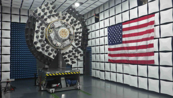
Image: PLD Space
“This project represents a strategic step forward in the development of our own navigation capabilities,” said Raúl Verdú, co-founder and chief business development officer of PLD Space. “With ESA’s support, we will enhance landing maneuver precision, gain vertical integration, and move towards the future integration of autonomous flight termination technologies in Europe.”
The proposal was selected under ESA’s NAVISP Spanish Call, launched in November 2024, arranged both by the Spanish Space Agency (AEE) and ESA. The call invited Spanish industry to propose innovative projects in the PNT field. PLD Space’s contract follows a rigorous technical and commercial assessment and has been favorably evaluated for its alignment with market demand, the competitiveness of the solution, and the strength of its commercialization strategy.
Technology for Europe’s Future in Space
The HALCON system will deliver centimeter-level positioning accuracy, enhancing both safety and operational efficiency. It is based on commercial off-the-shelf (COTS) components, significantly reducing development costs compared to traditional high-end solutions.
This technology will not only improve the reliability and sustainability of space transportation but will also pave the way for future capabilities such as a European Autonomous Flight Termination System (AFTS), which is not yet authorized on the continent. This capability is critical for increasing flight autonomy and mission safety in complex scenarios, while positioning Spain as a leader in next-generation launchers.
The development will be carried out entirely in-house by PLD Space’s engineering team, with ESA’s technical support, and will be integrated into the company’s technology roadmap, aligned with its reusability and operational autonomy plans through 2030.
A massive earthquake and subsequent tsunami off Russia in late July tested an experimental detection system that had deployed a critical component just the day before.
A recent tsunami triggered by a magnitude 8.8 earthquake off Russia’s Kamchatka Peninsula sent pressure waves to the upper layer of the atmosphere, NASA scientists have reported. While the tsunami did not wreak widespread damage, it was an early test for a detection system being developed at the agency’s Jet Propulsion Laboratory in Southern California.
Called GUARDIAN (GNSS Upper Atmospheric Real-time Disaster Information and Alert Network), the experimental technology “functioned to its full extent,” said Camille Martire, one of its developers at JPL. The system flagged distortions in the atmosphere and issued notifications to subscribed subject matter experts in as little as 20 minutes after the quake. It confirmed signs of the approaching tsunami about 30 to 40 minutes before waves made landfall in Hawaii and sites across the Pacific on July 29 (local time).
“Those extra minutes of knowing something is coming could make a real difference when it comes to warning communities in the path,” said JPL scientist Siddharth Krishnamoorthy.
Near-real-time outputs from GUARDIAN must be interpreted by experts trained to identify the signs of tsunamis. But already it’s one of the fastest monitoring tools of its kind: Within about 10 minutes of receiving data, it can produce a snapshot of a tsunami’s rumble reaching the upper atmosphere.
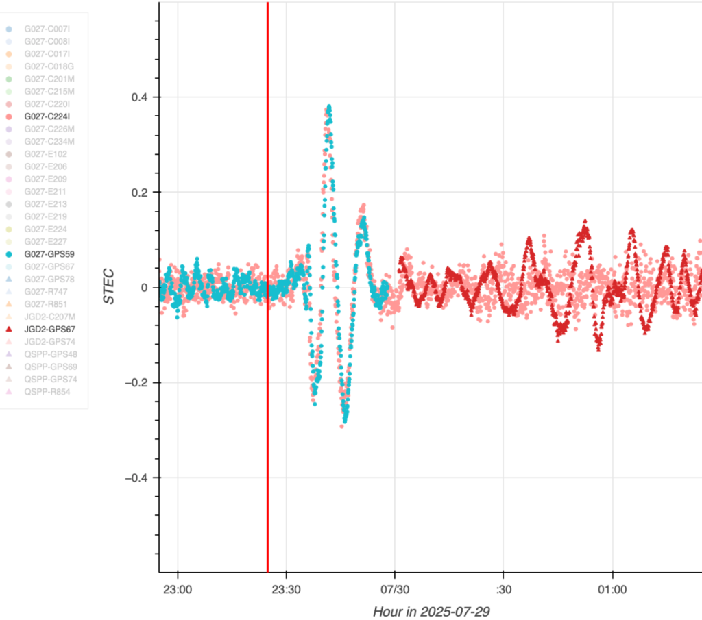
The dots in this graph indicate wave disturbances in the ionosphere as measured between ground stations and navigation satellites. The initial spike shows the acoustic wave coming from the epicenter of the July 29 quake that caused the tsunami; the red squiggle shows the gravity wave the tsunami generated. (Image: NASA/JPL-Caltech)
The dots in this graph indicate wave disturbances in the ionosphere as measured between ground stations and navigation satellites. The initial spike shows the acoustic wave coming from the epicenter of the July 29 quake that caused the tsunami; the red squiggle shows the gravity wave the tsunami generated.
The goal of GUARDIAN is to augment existing early warning systems. A key question after a major undersea earthquake is whether a tsunami was generated. Today, forecasters use seismic data as a proxy to predict if and where a tsunami could occur, and they rely on sea-based instruments to confirm that a tsunami is passing by. Deep-ocean pressure sensors remain the gold standard when it comes to sizing up waves, but they are expensive and sparse in locations.
“NASA’s GUARDIAN can help fill the gaps,” said Christopher Moore, director of the National Oceanic and Atmospheric Administration Center for Tsunami Research. “It provides one more piece of information, one more valuable data point, that can help us determine, yes, we need to make the call to evacuate.”
Moore noted that GUARDIAN adds a unique perspective: It’s able to sense sea surface motion from high above Earth, globally and in near-real-time.
Bill Fry, chair of the United Nations technical working group responsible for tsunami early warning in the Pacific, said GUARDIAN is part of a technological “paradigm shift.” By directly observing ocean dynamics from space, “GUARDIAN is absolutely something that we in the early warning community are looking for to help underpin next generation forecasting.”
How GUARDIAN works
GUARDIAN takes advantage of tsunami physics. During a tsunami, many square miles of the ocean surface can rise and fall nearly in unison. This displaces a significant amount of air above it, sending low-frequency sound and gravity waves speeding upwards toward space. The waves interact with the charged particles of the upper atmosphere — the ionosphere — where they slightly distort the radio signals coming down to scientific ground stations of GPS and other positioning and timing satellites. These satellites are known collectively as the Global Navigation Satellite System (GNSS).
While GNSS processing methods on Earth correct for such distortions, GUARDIAN uses them as clues. The software scours a trove of data transmitted to more than 350 continuously operating GNSS ground stations around the world. It can potentially identify evidence of a tsunami up to about 745 miles (1,200 kilometers) from a given station. In ideal situations, vulnerable coastal communities near a GNSS station could know when a tsunami was heading their way and authorities would have as much as 1 hour and 20 minutes to evacuate the low-lying areas, thereby saving countless lives and property.
Key to this effort is the network of GNSS stations around the world supported by NASA’s Space Geodesy Project and Global GNSS Network, as well as JPL’s Global Differential GPS network that transmits the data in real time.
The Kamchatka event offered a timely case study for GUARDIAN. A day before the quake off Russia’s northeast coast, the team had deployed two new elements that were years in the making: an artificial intelligence to mine signals of interest and an accompanying prototype messaging system.
Both were put to the test when one of the strongest earthquakes ever recorded spawned a tsunami traveling hundreds of miles per hour across the Pacific Ocean. Having been trained to spot the kinds of atmospheric distortions caused by a tsunami, GUARDIAN flagged the signals for human review and notified subscribed subject matter experts.
Notably, tsunamis are most often caused by large undersea earthquakes, but not always. Volcanic eruptions, underwater landslides, and certain weather conditions in some geographic locations can all produce dangerous waves. An advantage of GUARDIAN is that it doesn’t require information on what caused a tsunami; rather, it can detect that one was generated and then can alert the authorities to help minimize the loss of life and property.
While there’s no silver bullet to stop a tsunami from making landfall, “GUARDIAN has real potential to help by providing open access to this data,” said Adrienne Moseley, co-director of the Joint Australian Tsunami Warning Centre. “Tsunamis don’t respect national boundaries. We need to be able to share data around the whole region to be able to make assessments about the threat for all exposed coastlines.
Spire Global Inc., a global provider of space-based data, analytics and space services, was awarded a $11,190,900 contract from the National Oceanic and Atmospheric Administration (NOAA) to provide GNSS radio occultation (RO) data for a one-year period from Sept. 18, 2025, to Sept. 18, 2026.
The company’s near-real-time GNSS-RO data consists of vertical profiles of atmospheric measurements, including pressure, humidity and temperature, that can reach all points of the globe. NOAA, together with NASA, the U.S. Air Force and the U.S. Navy, will integrate Spire’s GNSS-RO data into their weather and space weather models, while additional U.S. and international agencies will leverage the data to strengthen forecasts and advance climate research.
“Spire’s satellites and radio occultation data are uniquely positioned to deliver the atmospheric insights needed to tackle today’s complex weather challenges,” said Theresa Condor, CEO at Spire Global. “Our continued work with NOAA underscores the importance of government–commercial partnerships in advancing weather forecasting and highlights NOAA’s commitment to harnessing innovation to improve forecasts and build climate resilience.”
The award is part of an Indefinite Delivery Indefinite Quantity (IDIQ) contract for NOAA’s Commercial Weather Data Program Radio Occultation Data Buy II.
The GEO-3 satellite Eutelsat 5 West B (PRN 121) is now part of the European Geostationary Navigation Overlay Service (EGNOS) operational platform and broadcasts the Operational Signal-in-Space.
PRN 121 began broadcasting operational signals Aug. 25 as part of EGNOS System Release 2.4.3. The upgrade seeks to strengthen service continuity and prepare the system for future enhancements.
The transition involved swapping satellite roles within the EGNOS constellation. On Sept. 5, the GEO-2 satellite ASTRA 5-B shifted from operational to test status, creating a new configuration with GEO-1 and GEO-3 handling operational duties while GEO-2 serves as the test platform.
The changes will not disrupt service or affect coverage areas, officials said.
“Eutelsat is proud of its long-standing collaboration with EUSPA,” said Arlen Kassighian, chief engineering officer of Eutelsat. “We are delighted to host this payload, which will continue to significantly enhance the performance of global navigation satellite systems across Europe in the coming years.”
The system release represents preparation for EGNOS V3, the next-generation platform that will offer enhanced performance, improved robustness and dual-frequency multi-constellation capabilities for European satellite navigation services, according to Jean-Marc Pieplu, head of EGNOS Exploitation Department.
The European Union Agency for the Space Programme manages the EGNOS space segment, system upgrades and service provision. The agency’s integration of the GEO-3 satellite ensures EGNOS continues providing reliable augmentation services for safety-critical and professional applications throughout Europe.
The European Space Agency (ESA) has confirmed plans to launch the first two satellites in its low-Earth orbit (LEO) positioning navigation and timing (PNT) constellation in the second half of December 2025. The launch will use a Rocket Lab Electron Vehicle, marking Europe’s first venture into LEO-based satellite navigation.
The LEO-PNT in-orbit demonstrator mission, called Celeste, aims to test satellite navigation capabilities in LEO and evaluate its integration with existing medium-Earth orbit (MEO) systems.
Celeste features a constellation of ten satellites that will fly close to Earth to test innovative signals across various frequency bands. The first two Celeste satellites, built in parallel by GMV and Thales Alenia Space, are set to launch in the coming months.
The dedicated Electron rocket launch will place both satellites in orbit at 510 km altitude. The launch window extends for three months beginning in mid-December 2025, with operations conducted from Rocket Lab’s New Zealand facility.
ESA Director of Navigation, Javier Benedicto, said, “We are thrilled to see the LEO-PNT demonstration advancing so quickly, with less than two years between mission kick-off and launch. This launch ensures the first European LEO-PNT satellites are in space before spring 2026, crucial for bringing the frequencies into use in compliance with the International Telecommunications Union.”
Galileo’s “Daughter Mission”
The name Celeste pays homage to Maria Celeste, Galileo Galilei’s daughter, as the two shared a strong emotional and intellectual bond, with the daughter honoring her father’s astronomical interest. This symbolic connection links the pioneering work of the father of modern astronomy to contemporary navigation systems, with Celeste serving as a bridge between Galileo’s groundbreaking discoveries and today’s satellite-based positioning technology.
The demonstrator satellites for Galileo, launched in 2005 and 2008, were called GIOVE, after the Italian word for Jupiter. This name also paid tribute to Galileo’s achievements in discovering the planet’s four largest Moons which were used to determine longitude from anywhere on Earth.
System Advantages
The initial Pathfinder A satellites are CubeSats measuring 12U and 16U formats, comparable to suitcase size and weighing approximately 20 kg to 30 kg. These satellites will broadcast in L-band and S-band frequencies and operate for at least six months following orbital commissioning.
The larger, more complex Pathfinder B satellites will follow, incorporating additional payloads to test innovative signals across multiple frequency bands and demonstrate expanded services.
LEO-PNT satellites will supplement existing GNSS constellations by providing enhanced coverage in challenging environments. The system aims to improve navigation services in deep urban areas, under heavy foliage, in polar regions and potentially indoor locations where current MEO satellites face limitations.
The complete demonstrator constellation, expected to be operational by 2027, will assess how LEO navigation systems can integrate with existing GNSS infrastructure. The mission will also test interoperability with 5G and 6G communication standards.
Preparing for Launch
Satellite integration and testing of Pathfinder A hardware and software continues ahead of the December launch. ESA and industrial teams plan to complete testing during summer 2025, with qualification and acceptance reviews scheduled for autumn.
“Pathfinder A satellites have already paid off, even before launch,” said Roberto Prieto-Cerdeira, ESA’S LEO-PNT project manager. “The experience gathered during their development is helping to identify critical technologies, system design trade-offs, design choices and optimised approaches and processes, paving the way for future phases of LEO-PNT. Having them in orbit and validating their signals and algorithms is a major additional achievement.”
Future Plans
Following the demonstrator mission, ESA plans to propose an in-orbit preparatory phase at the agency’s November Ministerial Council meeting. This phase would focus on technology development and industrialization, potentially leading to an operational system integrated with EU GNSS infrastructure.
The Celeste demonstrator is part of FutureNAV, an ESA Navigation program designed to maintain Europe’s position at the forefront of satellite navigation technology.
The mission receives backing from 15 ESA member states: Austria, Belgium, Finland, France, Germany, Hungary, Italy, Norway, Poland, Portugal, Romania, Spain, Sweden, Switzerland and the United Kingdom. More than 50 entities from 14 countries participate in the two development consortia awarded contracts in 2024.
The Department of the Air Force (DAF) has successfully launched the Navigation Technology Satellite-3 (NTS-3) Vanguard aboard the United Launch Alliance (ULA) Vulcan rocket on the USSF-106 mission from Cape Canaveral Space Force Station, Florida, on August 12, 2025. This mission marks the first U.S. national security payload launched on the Vulcan Centaur rocket, which represents a new era of launch vehicle capability for national defense.
“We have a strategic imperative to deliver science and technology that enables and accelerates a resilient hybrid space architecture for the space capabilities that the joint force depends on,” said Air Force Research Laboratory (AFRL) Commander and DAF Technology Executive Officer (TEO), Brig. Gen. Jason E. Bartolomei.
NTS-3’s Advanced Architecture
NTS-3 is an experimental integrated navigation satellite designed by the AFRL to enhance the robustness, resilience and responsiveness of space-based positioning, navigation and timing (PNT) services, crucial to both military and civilian applications. The satellite aims to advance the capabilities of existing global navigation satellite systems, such as GPS, through innovative technology that includes an advanced atomic clock timekeeping system, a reprogrammable receiver compatible with both legacy and advanced signals (the Global Navigation Satellite System Test Architecture), and Chips Message Robust Authentication, which defends against GPS spoofing.
NTS-3 features a fully reprogrammable software architecture that spans the space-based satellite, ground-based control system, and agile user receivers. This enables rapid software updates either on orbit or in the field, a significant departure from previous GPS satellites that required hardware changes for upgrades. This approach delivers not only military advantages in contested environments but also substantial benefits for civilian users who rely heavily on GPS for banking, agriculture, telecommunications and air traffic control.
“We rely on GPS so much, in ways that we don’t always think about,” said Rachel Gleichmann, NTS-3 deputy program manager, AFRL Space Vehicles Directorate. So, to make sure that it is resilient and that it’s always available and always accurate — or, as the military likes to say, ‘assured’ is extremely important to your average American.”
Industry partner L3Harris Technologies serves as the prime contractor, working alongside AFRL on the design, development, integration, testing, launch vehicle interface, and on-orbit operations of the satellite. The collaboration embodies a comprehensive ecosystem approach that leverages resources from government, industry, academia, and venture capital to foster innovation in national security space.