As we begin 2023, GNSS development continues apace, as described in this issue’s annual “Directions” section by representatives of Galileo, GLONASS, and BeiDou. We plan to publish a similar update on the GPS program soon.
Galileo’s user base now stands at more than 3.5 billion, and the services it provides continue to improve and expand. Beginning early this year, free precise point positioning (PPP) corrections for Galileo and GPS (single- and multi-frequency) will improve real-time user position by up to 10 times. While the discontinuation of Soyuz launch services from the Kourou Space Centre in French Guiana, due to the Russia-Ukraine conflict, delayed the two Galileo launches that had been planned for last year, 2022 was a key year for the development of Galileo Second Generation (G2G) satellites. They will provide, among other innovations, a reconfigurable fully digital navigation payload, point-to-point connection between satellites, and advanced jamming and spoofing protection mechanisms.
On Nov. 29, 2022, Russia launched the 51st Glonass-M satellite, about 20 years after launching the first one. Currently, 13 of these satellites are operating beyond their guaranteed lifetime, with an average orbit lifetime of more than 10 years. Starting this year, the constellation will be renewed by Glonass-K and Glonass-K2 satellites, which provide CDMA signals to users.
Currently, 45 BDS satellites are operational in orbits, including 15 BDS-2 satellites and 30 BDS-3 satellites. The constellation says that it has reached a continuity of 99.996% and an availability of 99%, with a global positioning accuracy better than 1.5 meters horizontally and 2.5 meters vertically (95% confidence).
Tracy Cozzens, who has been a pillar of this magazine for 17 years, is retiring this month. We will miss her journalistic acumen, dedication to clarity and style, attention to detail, and wealth of institutional knowledge. We wish her a well-deserved retirement. At the same time, we welcome aboard Maddie Saines, our new managing editor, who is near the beginning of her career.
I am pleased to announce that Rob VanBrunt has joined GPS World’s Editorial Advisory Board. In mid-December, the board of directors of Spirent Federal Systems, a provider of PNT test solutions for the U.S. government and contractors, appointed him as the company’s president/CEO-designate, a role he will assume when the onboarding process is complete.
VanBrunt began his career at Spirent Communications in 1990 as product developer and manager, and then held posts of increasing responsibilities, moving to director and vice president roles focused on management, strategy and mergers and acquisitions. Most recently, he was executive vice president in the Office of Business Excellence. VanBrunt has a B.S. in electrical and electronics engineering from Rutgers University.
Spirent Communications is a global provider of automated test and assurance solutions for networks, cybersecurity and positioning. In July 2001, the company formed Spirent Federal Systems as a wholly owned subsidiary and U.S. proxy company. Spirent Federal markets and sells Spirent Communications’ products in North America. It also provides value-added features and ongoing customer support.
On Jan. 1, I lost my beloved mother, Maristella “Mimi” Luccio. She was 87.
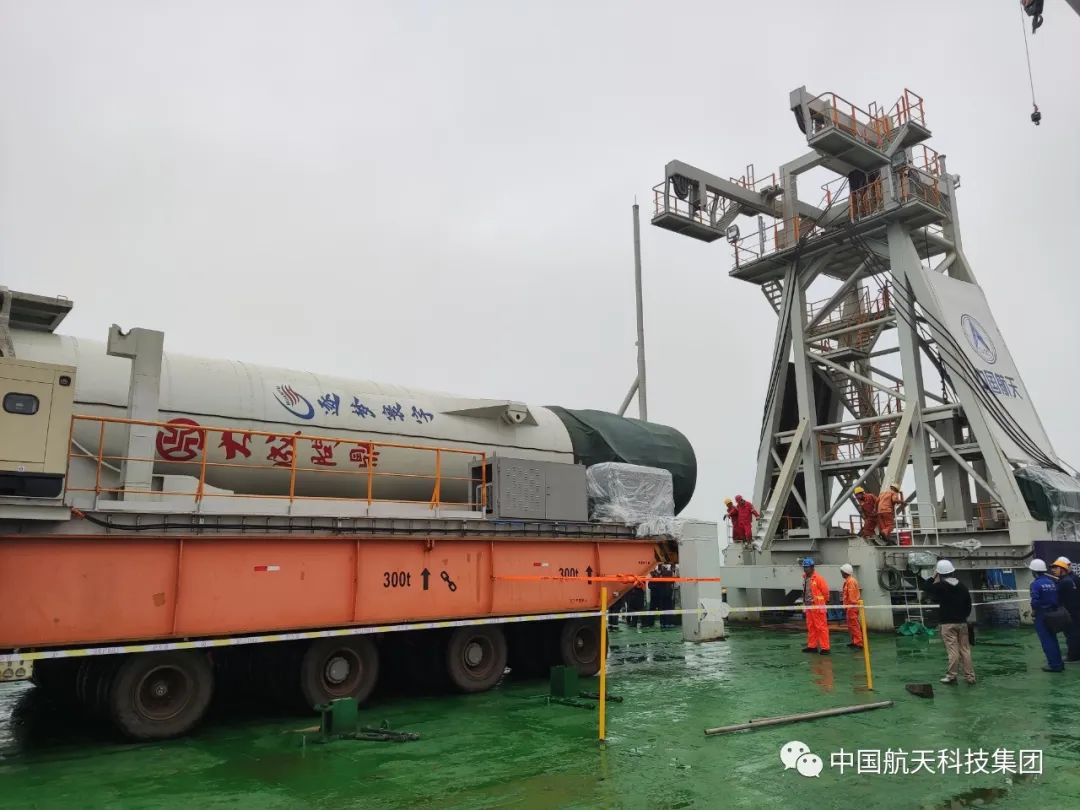
On Oct. 7, China launched a pair of satellites designed to enhance BeiDou navigation signals.
The CentiSpace-1 S5 and S6 satellites were launched via a Long March 11 solid rocket that lifted off at 9:10 a.m. EDT from a mobile sea platform in the Yellow Sea. Launch success was confirmed by the China Aerospace Science and Technology Corporation (CASC) 90 minutes later.
The CentiSpace-1 satellites are designed to enhance the accuracy of signals from China’s Beidou navigation and positioning satellite system. The satellites will also conduct inter-satellite laser link experiments.
“Seen & Heard” is a monthly feature of GPS World magazine, traveling the world to capture interesting and unusual news stories involving the GNSS/PNT industry.
3D mapping is helping forensic teams reconstruct fatal traffic accidents in Singapore, reports The Straits Times. In 2021, Singapore had 100 fatal road accidents. Experts use 3D replicas of the accident site and simulation models to recreate events leading to an accident and its aftermath. This helps forensic scientists determine whether the vehicles were speeding or flouting traffic rules. The National 3D Mapping Program of the Singapore Land Authority has mapped every road, lane and highway in Singapore with a 3D laser scanner and car-mounted cameras, and plans to update the maps regularly. Autonomous vehicles will also depend on the 3D point-cloud data.
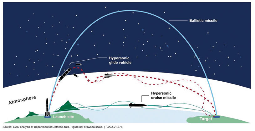
Diagram: U.S. General Accountability Office
BeiDou Enables Hypersonic Flight
In simulation drills using BeiDou, Chinese space scientists flew a hypersonic flight from Jinan, China, to New York over the Arctic Ocean, reports EurAsian Times. BeiDou facilitated contact between the command center on Earth and the hypersonic vehicle as it dodged enemy air defenses. Researchers claim using BeiDou provided a time lag of less than a second. They also claim to have optimized signal transmitters and designed new satellite-jumping methods to overcome communication challenges. China and Russia are the only countries with operational hypersonic weapons — Russia has used its Kinzhal hypersonic missile in the Ukraine war.
Indonesia’s National Research and Innovation Agency (BRIN) and Dr. Soetomo University are cooperating on aerial photo mapping using an unmanned aerial vehicle and GNSS hardware. BRIN’s Ocky Karna Radjasa said he expects that the two parties will extend the opportunity to advance research and innovation as well as bolster the quality of education in Indonesia. The university’s Nur Saidah expects BRIN’s support will increase, stating, “We still have limitation in laboratory facilities, so we seek industry cooperation. Let us hope that, as a result of this cooperation, we can receive help.”
A new navigation system addresses shortcomings of GNSS using cosmic-ray muons. Muometric navigation enables positioning underground, indoors or underwater within a reference coordinate system defined by the 3D positions of multiple detectors, researcher Hiroyuki K. M. Tanaka explains in the June issue of Nature. Tanaka’s work shows the system offers a navigation quality almost equivalent to aboveground GPS-based handheld navigation by determining the distance between the reference frame and the receivers with a precision of 1 to 10 meters.
“Seen & Heard” is a monthly feature of GPS World magazine, traveling the world to capture interesting and unusual news stories involving the GNSS/PNT industry.
A “BeiDou positioning system for subways” began construction March 20 on the Beijing subway capital airport express line. The project will cover a 30-kilometer-long section of the express line, including five stations. To provide positioning, the BeiDou Navigation Satellite System (BDS) will be combined with 5G for indoor positioning or in areas where the satellite signals are blocked. The system will improve the positioning accuracy in subways to less than 2 meters, making it available for vehicle dispatching, passenger transport organization and emergency response. In addition, it allows passengers to use their phones to navigate and position in complex environments in subway stations through three-dimensional navigation.
Image: ESA
THE SHAPE OF OCEAN WATER
The European Space Agency (ESA) investigated a technique to precisely measure sea-surface topography based on an idea submitted by the Institute for Space Studies of Catalonia (IEEC). The technique involves GNSS reflectometry — signals that have been reflected off of the sea surface at very low angles. The ESA-funded activity involved developing a GNSS receiver and setting up an experiment in the Balearic Islands to collect GNSS signals reflected off the sea surface. The team linked the coherence of the reflected signals to wave height and elevation angle of GNSS satellites. The team then processed the signals for optimized measurements of the shape of the sea surface, useful in applications such as ocean current forecasting, climate research, ship routing, cable laying and debris tracking.
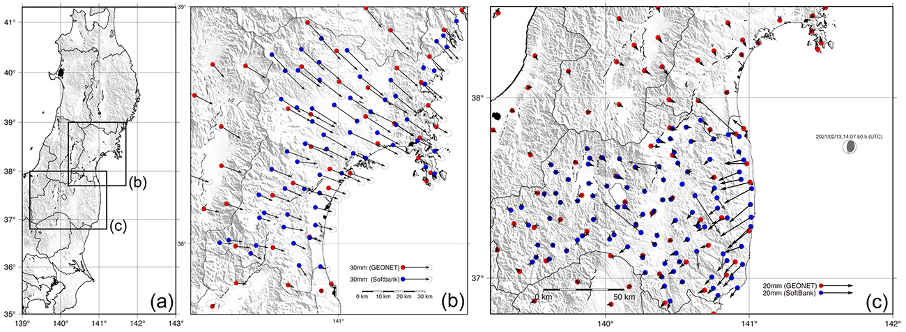
Image: Japan network/Ohta and Ohzono, Tohoku University
CELLPHONE NETWORK DETECTS EARTHQUAKES
A paper published Feb. 9 in Earth, Planets and Space by Japanese Earth science researchers analyzed the potential of a dense network of GNSS receivers, installed at cellphone base stations, to monitor crustal deformation as an early warning indicator of seismic activity. Results showed that data from a cellphone network can rival the precision of data from a government-run GNSS receiver network, while providing more complete geographic coverage. Japanese cellphone carriers have constructed networks of GNSS receivers to improve locational information for such purposes as automated driving. The study examined the potential of a GNSS network built by SoftBank Corp. to play a role in monitoring crustal deformation.
Photo: Falklands Maritime Heritage Trust
ENDURANCE IN POLAR ICE
Researchers have discovered the remarkably well-preserved wreck of polar explorer Ernest Shackleton’s ship, Endurance, a century after it was swallowed up by Antarctic ice. A team of marine archaeologists, engineers and other scientists used an icebreaker ship and underwater drones to locate the wreck at the bottom of the Weddell Sea, near the Antarctica Peninsula. The ship is at a depth of 3,008 meters, 4 miles south of the position originally recorded by navigator Frank Worsley. The expedition team used two Saab autonomous underwater vehicles to explore in a pre-programmed search pattern. After the ship was located, technicians swapped out sonar equipment for a high-resolution camera and a laser-surveying device to make highly detailed scans of the site.
A “BeiDou positioning system for subways” began construction March 20 on the Beijing subway capital airport express line. The project will cover a 30-kilometer-long section of the express line, including five stations.
To provide positioning, the BeiDou Navigation Satellite System (BDS) will be combined with 5G for indoor positioning or in areas where the satellite signals are blocked.
The system will improve the positioning accuracy in subways to less than two meters, making it available for vehicle dispatching, passenger transport organization and emergency response. In addition, it allows passengers to use their phones to navigate and position in complex environments in subway stations through three-dimensional navigation.
“We will combine indoor and outdoor positioning in subways, that is, Beidou and its augmented reality technology will be used outdoors to achieve high-accuracy positioning, and indoor positioning technology integrated with 5G will be used to allow users to receive indoor positioning signals,” said Lin Luzhou, vice president of the GNSS and LBS Association of China.
The project is the largest indoor space navigation and positioning system in China, according to ECSN.com, and is expected to be finished within this year.
ION’s Pacific PNT Conference is a global cooperative development of Positioning, Navigation and Timing technology and applications where policy and technical leaders from around the world meet to discuss policy updates, receive program status updates and exchange technical information.
The 2022 conference will be hosted virtually April 11-13 PDT on a complimentary basis for ION members. The conference will include sessions on policy and status updates, performance schedules and plans, plus special challenges affecting Asia-Pacific presented by an elite list of experts representing BeiDou, COSMIC/ FORMOSAT, and QZSS.
A session will broadcast each day at 9:00 a.m. JST / 5:00 p.m. PDT. Live-stream attendees will have the opportunity to participate in virtual question and answer periods through the portal.
ComNav Technology Ltd. is providing GNSS technology to Africa for projects in land mapping, continuously operating reference station (CORS) construction, precision agriculture and other fields, according to a Feb. 11 article in People’s Daily, the largest newspaper in China.
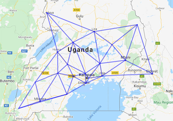
Every day, thousands of users in Africa are using GNSS products, the newspaper stated, highlighting specifically the use of China’s BeiDou satellite navigation system. For instance, CORS using ComNav GNSS/BeiDou receivers have been built in 11 sub-Saharan African countries, including Kenya and Uganda.
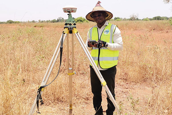
Uganda. To meet the demand for high-precision GNSS, the government of Uganda purchased ComNav’s real-time kinematic (RTK) receivers to build its own CORS. Thirty stations have been built so far, creating the most advanced CORS network in East Africa. Its high-precision spatial and temporal information supports land mapping, mining, vehicle management and meteorological monitoring, among other industries.
In 2015, Mulindwa David, chairman of the Uganda Surveying Association, and others visited the Shanghai headquarters of ComNav to learn about its high-precision products and technologies. After training, David and others mastered basic RTK operation and learned simple maintenance.
David used to carry heavy optical equipment every day, but now he only needs to hold a BeiDou receiver to process the relevant data, which has greatly improved his work efficiency and accuracy. “It took at least three days to survey a dozen kilometers of road with optical equipment,” he said. “With BeiDou high-precision receivers, only 10 hours is enough.”
The Uganda CORS network. (Image: ComNav)
Burkina Faso. In response to the COVID-19 outbreak, the Burkina Faso government decided to build a hospital for infectious diseases. In April 2021, it used ComNav GNSS high-precision technology to provide survey data for the hospital’s construction. The land security and topographic surveying tasks were completed in six days, half the time scheduled, said Augustin Bamouni, secretary-general of the country’s national surveying association.
A surveyor in Burkina-Faso surveys the site of a new hospital for infectious diseases. (Photo: ComNav)
Tunisia. The China-Arab BeiDou/GNSS Center is located in the Ghazara Science Park in northern Tunis, the capital of Tunisia. Inaugurated in 2018, it is China’s first overseas BeiDou center, providing satellite navigation training, test evaluation and technical research for African and Arab countries. On average, the center receives real-time data from more than 12 BeiDou satellites at once.
The center will help Tunisia and other African countries train professionals in GNSS technology to support development of the digital economy, according to Amiri Khalil, state secretary in charge of scientific research at Tunisia’s Ministry of Higher Education.
China-Arab BeiDou/GNSS Center is in Tunis, Tunisia. (Photo: ComNav)
China-Africa Forum. The first China-Africa BeiDou System Cooperation Forum was held in November 2021 in Beijing to encourage cooperation between China and Africa and promote use of BeiDou. Four cases from ComNav Technology were described in the forum’s document citing application scenarios of BeiDou in Africa.
ComNav Technology has deepened its cooperation with Africa since China’s Belt and Road Initiative began in 2013. Besides providing products and technologies, ComNav arranged employees to go abroad to provide technical support, traveling to Cameroon, Nigeria, Mali, Zambia, and other African countries. Despite the pandemic, ComNav continues to provide professional service and training both in person and remotely.
China and the Arab states will expand their cooperation in using the China-developed BeiDou Navigation Satellite System (BDS), according to the third China-Arab States BDS Cooperation Forum and reported by XinhuaNet.
China and the Arab states will jointly implement pilot projects in key domains in the application of BDS and GNSS over the 2022-2023 period, according to a cooperation action plan signed at the forum, held Dec. 8 in Beijing.
Both sides will facilitate the establishment of BDS/GNSS centers in the Arab states, hold training courses on satellite navigation technologies, and exchange visiting scholars. Each year, China will offer scholarships to three to five students majoring in navigation and communications from the Arab states, said the action plan.
China and the Arab states will also carry out joint BDS/GNSS tests and evaluations, and promote the application of BDS in international search and rescue, among other initiatives.
All the moves are expected to boost “win-win cooperation” and make BDS better serve the Arab states, said the action plan.
This year’s forum was held after China officially commissioned BDS on July 31, 2020, opening the new BDS-3 system to global users.
Along with positioning, navigation and timing services, the BDS-3 system can provide a variety of value-added services such as global search-and-rescue assistance, short message communication, ground- and satellite-based augmentation, and precise point positioning.
The forum highlighted the achievements and experience of China and Arab states in BDS/GNSS cooperation and proposed a platform for both sides to upgrade the win-win cooperation.
BeiDou benefits in Arab States
The BDS-based applications and solutions have benefited multiple industries in Arab states. BDS has been providing real-time, continuous, stable and precise GNSS positioning information data and timely information via continuously operating reference stations (CORS) in Tunisia, Algeria and other places.
High-precision BDS/GNSS applications are also serving diverse fields such as land mapping, transportation, precision agriculture and environmental monitoring.
Project management of railway construction in the United Arab Emirates (UAE) has benefitted from the integrated technologies of BDS/GNSS and the internet of things, with efficient use of data and information.
BDS has entered a new phase of industrial and international development, according to the China Satellite Navigation Office.
First, there was one. In July 1995, the U.S. Air Force declared the Global Positioning System had met all the requirements for full operational capability (FOC). Soon thereafter, there were two. In December of that same year, Russia’s Globalnaya Navigazionnaya Sputnikovaya Sistema (Global Navigation Satellite System, or GLONASS), also achieved FOC. For a quarter century, that was it.
Then, last year, the number doubled, as both the European Union’s Galileo and China’s BeiDou Navigation Satellite System (BDS, named after the Big Dipper asterism, which is known in Chinese as Beidou) achieved FOC.
The Indian Regional Navigation Satellite System (IRNSS, aka Navigation Indian Constellation, or NavIC, which means “sailor” or “navigator” in Hindi) and Japan’s Quasi-Zenith Satellite System (QZSS, also known as Michibiki) are not global yet, but plan to become so. Currently, NavIC is an autonomous regional satellite navigation system, and NavIC-based trackers are compulsory on commercial vehicles in India. QZSS currently complements GPS to improve coverage in East Asia and Oceania, but Japan plans to have an operational constellation of seven satellites for autonomous capability by 2023. The Korea Positioning System (KPS) plans to join the party by 2035.
Who’s next? Will it be another country or a private company? Given that the state-sponsored systems are free to end users, I don’t see what the business model would be for a private GNSS constellation, unless it were to piggyback on one built mainly for another purpose.
Surveyors who have begun to routinely use three or more constellations are over the moon. One, quoted in this month’s cover story, recalls that “the use of GPS for construction staking was an extremely risky proposition” because its residuals exceeded most construction tolerances. Using multiple GNSS constellations, however, has increased confidence in the accuracy of results to the point that some construction companies are relying on GNSS receivers for staking. Additionally, multi-constellation receivers can now increasingly be used under tree canopies and against structures, whether natural or built.
Whatever their mix of military, political and commercial motivations for building, deploying and operating their own GNSS constellations in addition to the original two, the European Union, China, India, Japan, Korea and whichever entity may follow are greatly improving satellite-based positioning, navigation and timing (PNT) for all users everywhere — by increasing accuracy, shortening the time to first fix, and making GNSS more impervious to jamming and spoofing.
In 1978, the year that the U.S. Department of Defense launched the first NAVSTAR GPS satellite (“NAVSTAR” was later dropped from the system’s name), Neil Young sang “Four Strong Winds” (originally written by Ian Tyson and performed by him with his wife Sylvia as the Canadian folk-duo Ian and Sylvia).
Now, GNSS has “four strong winds,” two lighter ones and several more breezes to follow. As a sailor and a navigator, I welcome them heartily. As this magazine’s editor-in-chief, I don’t mind that, like Jeep, Kleenex, Popsicle and Xerox, GPS probably will stick in popular culture as a generic term for global satellite navigation systems way past its accurate description of what is in the box.
What is the single most valuable lesson GPS can learn from Galileo and/or BeiDou?
Bernard Gruber
“Service continuity. Given that GNSS are so ubiquitous today, similar to the electrical grid, it is imperative that GPS continue the superb system of outage reporting via NANUs, transparency via GPS.gov, and statutory commitments via U.S. Code. Aligning to the U.S. commitment, continued Open Service Signal-in-Space, such as GPS-Galileo-BeiDou, allows thousands of planned and interoperable “apps” such as Google Maps and Waze to thrive. Although not directly in line with the question, terrestrial timing backup systems, similar to what China and some other countries do, is a valuable lesson in continuity from BeiDou.”
Bernard Gruber
Northrop Grumman
Ellen Hall
“Perhaps the lesson could be, ‘It’s easier not to be first!’ Newer navigation constellations have the benefit of watching and learning from GPS — things done well and things to improve. From technology to operational procedures, a global navigation satellite system (GNSS) is difficult to execute. Would it have been easier or cost less if the United States had decided to land on the Moon after someone else had paved the way? Probably, but there is something very satisfying about being first! And, despite the fact that GPS satellites outlive their life expectancy, we keep launching new ones, with improved technology, to give the world better accuracy and more robust signals. The world of navigation welcomes Galileo, BeiDou, and all the others to follow.”
Ellen Hall
Spirent Federal Systems
Alison Brown
“GPS could benefit from lessons learned from BeiDou as to the importance of resilience in providing PNT services. BeiDou has a total of 42 satellites now in operation and open signals are broadcast on six frequencies (B1I, B1C, B2I, B2a, B2b, and B3I). In comparison, GPS has currently 29 operational satellites and provides open signals on three frequencies (L1, L2, L5). As the global threat to GPS grows, from frequency incursions by evolving 5G systems as well as deliberate interference or spoofing, the ability to operate on different frequencies to provide resilience against harmful interference will become increasingly important.”
Alison Brown
NAVSYS Corporation
Jean-Marie Sleewaegen
“While GPS remains a gold standard with decades of reliable service, the advent of BeiDou and Galileo has undoubtedly stirred up competition. While BeiDou is exceptionally fast at deploying new signals and services, Galileo is now transmitting the first ever authenticated OSNMA signals, helping secure GNSS receivers against spoofers. The main lesson is that it is better to have company than to be alone. Having multiple GNSS not only increases the number of satellites and signals, which improves positioning accuracy and reliability, but more importantly, it fosters continuous innovation, for the benefit of all users.”
Photo: Philipp Berezhnoy/iStock / Getty Images Plus/Getty Images
According to a new research report, “GNSS Simulators Market by Component Type (Single Channel and Multichannel), GNSS Receiver (GPS, Galileo, GLONASS and BeiDou), Application (Vehicle Assistance Systems, Location-based Services and Mapping), Vertical, and Region — Global Forecast to 2025,” the market is estimated to grow from $106 million in 2020 to $165 million by 2025, at a compound annual growth rate (CAGR) of 9.3% during the forecast period.
Factors such as rapid penetration of consumer internet of things, the contribution of 5G in enabling ubiquitous connectivity and increasing use of wearable devices utilizing location information are expected to drive the adoption of the GNSS simulators hardware, software and services, the MarketsandMarkets report said.
Market segments
The report stressed several key points in regard to the hardware segment, automotive vertical segment and GPS segment.
The GNSS simulators market, by component, is segmented into hardware, software and services. Of these three, the hardware segment is expected to account for a larger market size in the coming years in the GNSS simulators market as it enables signal simulations and plays a key role in the simulation process.
The GNSS simulators market, by vertical, is segmented into military and defense, automotive, consumer electronics, aerospace, marine and other verticals (agriculture, construction, and rail and road). According to the report, the automotive vertical segment is expected to hold a higher CAGR during the forecast period in the GNSS simulators market.
“GNSS offers a cost-effective and accurate way of determining position in real-time,” the report said. “Ride-sharing apps, such as Uber and Lyft, car-sharing, usage-based insurance apps, dynamic toll charging and parking apps all depend on the real-time location of the car. GNSS offers sufficient accuracy for all these apps by providing location coordinates leading to its adoption in the automotive vertical.”
Next, GNSS receivers are segmented into GPS, GLONASS, Galileo, BeiDou and others, with the others comprised of NavIC and QZSS receivers. The satellite tracking service provided by GPS is useful in various commercial and personal applications. The increasing commercial application of GPS vehicle tracking system for taxi companies and cab services is contributing to the rising adoption of GPS location services. It makes the navigation easier by providing relevant details, such as distance and shortest route to the desired location, the report said.
Market size and location
North America is expected to have the largest market size during the forecast period, with the key factor favoring the growth of the GNSS simulators market in North America being the increase in technological advancements coupled with the rise in government support for the adoption of UAVs. The increasing number of players across different regions is also further expected to drive the GNSS simulators market globally, the report said.
In addition, Asia-Pacific is projected to grow at the highest CAGR during the forecast period, as it has witnessed considerable developments and adoption of solutions across the region. According to the report, Asia-Pacific has a large potential for GNSS and space-enabled applications, and it has a wide consumer base due to its booming economies accompanied by an increasing share of local R&D and technology innovations.
Major players
Major vendors in the global GNSS simulators market include Spirent Communications, Rohde & Schwarz, VIAVI Solutions, Hexagon, Keysight Technologies, u-blox, Orolia, Cast Navigation, Accord Software and System, IFEN, Racelogic, Syntony GNSS, Teleorbit, iP-Solutions, Pendulum Instruments, Saluki Technology, Shanghai Huace Navigation Technology, Averna, GMV NSL, Brandywine Communications, Jackson Labs Technologies, Hunan Shuangln Electronic Technology, Work Microwave, Qascom and M3 Systems.
integration with inertial measurement units (IMUs) and other sensors
positioning using cell phones and other consumer devices
any other areas or challenges they find particularly significant.
All four respondents in this issue, like to those in the January issue, report that they are making full use of the new GNSS signals available, taking hardware and software measures to counter jamming and spoofing, and integrating IMUs and other sensors with their GNSS receivers to help achieve continuous navigation and positioning in obstructed environments. In addition, they are continuing to develop mass-market applications, because high-precision positioning is becoming increasingly important for cellphones and wearable devices. For a fuller review of these trends, see my introduction to the first installment.
Notably, two of the companies featured in this issue, ComNav Technology and Unicore, are Chinese.
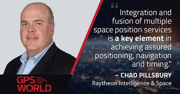
With Chad Pillsbury, Senior Director, Raytheon Intelligence & Space’s Resilient Navigation and Reconnaissance Solutions
Utilizing Galileo and BeiDou
Integration and fusion of multiple space position services is a key element in achieving assured positioning, navigation and timing (PNT). A combination of commercial and military-code navigation signals, when coupled with evolving sensors, provide more resilient methods of navigation and enable new concepts of operations related to PNT. Over the next two years, RI&S will customize these concepts of operation (CONOPS) for our United States and international allies to harness the power of fusion in resilience.
Dealing with jamming and spoofing
As threats to GPS continue to evolve and mature, RI&S continues to develop alternative navigation solutions, as well as GPS-capable receivers and antennas, aimed at defending against a variety of spoofing and jamming technologies. Our latest anti-jam, anti-spoof and high-precision solutions leverage a recent technology breakthrough that lowers size, weight, power and cost while boosting performance in the new M-code and alternative navigation applications.
Integration with IMUs and other sensors
IMUs are the cornerstone of high-performance navigation systems and will continue to be in the future. Recent innovations allow some systems to become more IMU agnostic, or even to consider microelectromechanical systems (MEMS) IMUs depending on performance, which can allow the customer greater flexibility and a more open architecture.
Positioning with consumer devices
RI&S sees 5G as a game-changing technology, with a lot of possibilities in the assured navigation market. We also look to cellphones as a great area of interest — especially for exploring unforeseen signals, considering human international models, and learning how the next generation of GPS users expect to see PNT information displayed.
Other significant challenges and opportunities
The future of GPS lies in a system-of-systems approach. Using time as a backbone, navigation systems can securely share time, data, position and intent across the network. Broadly, this approach can be used in civil, commercial and military environments. RI&S is fully focused on developing capabilities to achieve this ideal state.
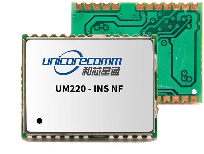
Unicore Communications
With Gao Jingbo, Marketing Director
Utilizing Galileo and BeiDou
Most of Unicore’s high-precision products support all constellations and multiple frequencies. The new BeiDou 3 provides precise point positioning (PPP) service from three geostationary satellites via the B2b frequency, while Galileo offers up to five frequencies — E1, E5a, E5b, E5 AltBOC and E6. End users will benefit from improved PNT availability, reliability and continuity as access to those signals greatly reduces multipath effects and allows faster PPP convergence times.
Dealing with jamming and spoofing
To effectively deal with signal jamming and spoofing, it is important to know their sources. GNSS receivers also are susceptible to electronic interference and vulnerable to complex electromagnetic environments. Unicore integrates GNSS RF, baseband and algorithms into a single GNSS system-on-chip (SoC) that mitigates external interference. Joint time-frequency domain interference mitigation technology also is adopted in chip design.
Photo: Unicore Communications
Integration with IMUs and other sensors
Demand for seamless, accurate indoor-outdoor location is increasing. The integration of GNSS with IMUs, lidar, cameras and other sensors helps achieve continuous navigation and positioning in obstructed environments such as urban canyons and tunnels. Unicore offers receivers integrated with both high-end IMUs and affordable MEMS-based devices. Dual-frequency GNSS plus MEMS provides an ideal positioning solution for automotive applications.
Positioning with consumer devices
High-precision positioning is becoming increasingly important for cellphones and wearable devices, and multi-scenario adaptation is necessary. Instead of integrating standalone GNSS chips with smartphone processors, cellphone manufacturers prefer to cooperate with GNSS manufacturers through GNSS intellectual property (IP) licensing. To ensure high-precision service, better cellphone antennas are also important.
Other significant challenges and opportunities
We strive to deliver reliable, timely and smart positioning for anything, anywhere, anytime. Next-generation GNSS location products and services should be more end-user-friendly. The hardware interface will be more universal, flexible, configurable and adaptable with different algorithms for a diverse range of applications.
Teleorbit
With Daniel Seybold, CEO
Utilizing Galileo and BeiDou
Our GOOSE receiver has been able to use Galileo since its beginning and BeiDou since the forth quarter of 2020. Signals from both can be used individually or with other signals (GPS, Galileo, GLONASS and BeiDou, plus SBAS).
Dealing with jamming and spoofing
Open Service Navigation Message Authentication (OSNMA) is now implemented on the GOOSE, which helps mitigate spoofing attacks. GOOSE’s recording function enables users to record simulated jamming/spoofing attacks, and then analyze the behavior of the GOOSE and the received signals. We are developing various GNSS antenna arrays for nulling and beamforming, as well as a left- and right-hand circular polarized (LHCP/RHCP) antenna with GOOSE adaption for signal processing.
Signal conditioning on the GOOSE platform is based on a high-rate discrete Fourier transform (DFT)-based data manipulator algorithm, known as an HDDM algorithm, that fulfills multiple roles. The HDDM algorithm removes a wide range of interference signals, equalizes the spectrum, or restructures the spectrum.
Image: Teleorbit
Integration with IMUs and other sensors
We offer a GNSS antenna with an integrated IMU. Thanks to its open software interface, fusing IMU or other sensor data with GNSS data is easily done with GOOSE. Vector tracking, deep coupling and other sensor fusions (for example, 5G) are on the GOOSE roadmap.
Positioning with consumer devices
Our ongoing AMELIE project will study advanced techniques for the miniaturization and radiation enhancement of GNSS mass-market antennas to be applied in the design, manufacturing and testing of a multi-frequency, low-cost, high-gain dual circularly polarized antenna for the next generation of consumer devices. In 2021, we will build the following antenna demonstrators: single-frequency (L1/E1), dual-frequency (L1/G1/E1, L5/E5a/E5b) and multi-frequency (L1/G1/E1, L5/E5a/E5b, L2, E6).
Other significant challenges and opportunities
GOOSE can track the Galileo E5AltBOC (wideband) signal, which provides code-range variances below a few decimeters. This offers a significant increase in the accuracy of code measurements in terms of reduced noise and mitigation of multipath effects, compared to conventional signals. GOOSE will provide two different approaches for robust tracking: vector tracking for dealing with challenging environments where multipath occurs or buildings block signals, and adaptive tracking to allow the receiver to acclimate to its surroundings by adapting the bandwidth in the loop depending on movement, such as high dynamics.
ComNav Technology
With Min Xu, Director of GNSS Technology R&D Department
Utilizing Galileo and BeiDou
We keep up with the development of GNSS. Our new K8 series of high-precision GNSS modules support the recently completed BDS-3 and Galileo constellations concurrently, significantly improving positioning accuracy especially when signals are partially obstructed. Despite their complex design, the size of K8 modules decreased by almost 36% from their precursors and power consumption dropped to 1.0W, making them easier to integrate.
Dealing with jamming and spoofing
We have developed algorithms to eliminate specific forms of jamming and spoofing, with a focus on narrowband interference. The newly released Quantum III SoC chip — integrated with wideband signal-receiving technology, wideband and narrowband anti-interference technology, and anti-continuous wave interference technology — can provide high-quality observation information in a complex electromagnetic environment.
Photo: ComNav Technology
Integration with IMUs and other sensors
There is an increasing need to add IMUs to supplement obstructed GNSS signals. Empowered by a high-precision IMU, our N5 receiver supports tilt survey with accuracy of less than 2.5 cm. Users can survey without a centering bubble as its calibration-free tilt compensation protects it from magnetic disturbances. We are also focusing on image sensors, such as cameras and radars, to make data collection more flexible and reliable.
Positioning with consumer devices
Our high-precision products are mainly used in professional fields such as land surveying, deformation monitoring, and UAVs. We are continuing to explore GNSS products for consumer markets, which are sensitive to power consumption and cost. The upcoming M10 GNSS is a compact and portable receiver for mass-market applications, such as person or vehicle tracking and fleet management.
Other significant challenges and opportunities
GNSS technology can be widely applied in agriculture, transportation and infrastructure construction. We developed the AG360/AG360 Pro Agricultural Automatic Driving system, which drives autonomously without damaging crops. We collaborated with China Mobile to build more than 2,000 CORS stations to provide high-precision positioning services in support of smart-city construction, IoT and location-based services.