Category: GLONASS

  • GPS/GLONASS Dispute: CEO Clarifies Misunderstandings

    GPS/GLONASS Dispute: CEO Clarifies Misunderstandings

    Javad Ashjaee
    Javad Ashjaee

    “Use any opportunity to create friendship and peace,” urged Javad Ashjaee, president and CEO of JAVAD GNSS, in a May 23 conversation with journalists. He decried the recent controversy about monitoring stations on both U.S. and Russian soil, saying it was based in misinformation and misinterpretations, inflated by a political crisis in a completely different area. “This [GNSS] is a good thing, that for 25 years kept us together. And if you see, there are lots of high-level meetings between U.S. and Russian officials, they are all very friendly meetings.”

    A transcription of his remarks appears here, below the following main points and clarifications that he wished to make:

    • Earlier this year, Russia sought GLONASS monitoring stations in the United States, not for uploading any data, but for monitoring GLONASS satellites to provide more accurate orbit and clock information, for the free and open benefit of all users.

    • The Russian general who threatened to close down monitoring stations on Russian soil that contribute data to the International GNSS Service was immediately and roundly criticized by Russian scientists and surveyors.  The general subsequently retracted his remarks.

    • The 11-hour GLONASS outage on April 1 was not due to a wait for all satellites to pass over ground control stations on Russian soil to receive a fresh upload of data.  GLONASS has the capability (as does GPS) to make such updates via inter-satellite communication. The delay was caused by the time it took to find the bug in the erroneous software that had been uploaded, and to correct it.

    • Ashjaee also noted that “No military activity requires millimeter accuracy. It is only scientific applications for humanitarian tasks that require millimeter accuracy.  Needing more monitoring stations, such as the IGS stations, is only for that purpose.”

    The Background

    Javad Ashjaee, founder and CEO of JAVAD GNSS, contacted GPS World on May 20 with a message: “I had a discussion today with the head of the GLONASS program in RosKosmos regarding the tracking sites that they wanted to establish in the United States, and the subsequent events. What has been published in most U.S. media is far from the truth. It is time that we contribute to defusing problems rather than putting more fuel on the fire. The world has enough problems already.”

    The Full Statement

    This is the story of GPS/GLONASS. It also gives some insight as to how things get out of control, and much, much bigger issues like war and things like Ukraine  get created. It is just a tiny, simple example.

    When I first heard the issue of GLONASS about 25 years ago and was invited by RosKosmos to Moscow, I didn’t think of Communism or anything political, I thought “30 satellites free, that they’re willing to give to the world, free of charge.” That’s how I got excited. Recently, GPS World published a wonderful history of the growing development of GLONASS and GPS.

    What bothers me now is some negative reactions that I see towards GLONASS. It seems that when they see something negative about GLONASS, they enjoy it. In the reports, read between the lines. When there is a problem with GLONASS, you sense some sort of happiness. There is something of “them versus us.”

    There was the question, “Why do they need things in our country? Don’t they have them in their country?”

    When people don’t know each other, they fear and they create fear.

    One thing we should look at: GLONASS is good for all of us. As President Reagan offered GPS free of charge to the world, and everybody applauded him — the Russians have done the same thing. In Oklahoma, California, everywhere, farmers and surveyors are using GLONASS free of charge, the same as GPS.  And GLONASS has been better, and I emphasize, it has been better because they didn’t encrypt their code so that we had to go behind and decipher and decrypt and all the trouble that we went to during the past 20 years, because GPS didn’t think that we need carrier phase.

    GLONASS is good for America, for the world, as is GPS. If there is a problem with GLONASS, we must be unhappy, as we are unhappy when there is a problem with GPS. And if we can help GLONASS, we must help GLONASS. There is nothing to fear about war, nobody needs [millimeter-level] accuracy of GPS or GLONASS if there is a war between super-powers.

    We should all want GLONASS to give precise information. We care about centimeter-level accuracy, the military doesn’t. Five-meter accuracy is good enough for them. To improve the precise-orbit information of GLONASS is the concern of surveyors and those that need precision GPS.

    Now, what’s the issue? GLONASS needs 50 reference stations all around the world to monitor the orbits of its satellites, to make the precise-orbit information [furnished to users] better. Not to upload information to the satellites. For this, one station is enough, for both GPS and GLONASS, because both have inter-satellite connections that can do this.

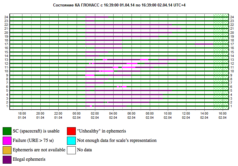
    There was speculation in early April that it took GLONASS 11 hours to correct a software bug because it took that long for all the satellites to pass over a control station on Russian soil. This was not the case, I have learned from conversations with their engineers and with the head person responsible for all of this. One engineer made a mistake and uploaded the wrong software. Until they could find it and debug it — and it took them 11 hours to do so — they could not upload correct software to the satellites.

    What they are asking for from the United States is not an upload station. They need as many [globally-distributed] monitoring stations as possible; 50 is good.

    The International GNSS Service (IGS) has 300. To have a good orbit determination for scientific work, to get to the depth of centimeter- or millimeter-level accuracy, the objectives of IGS reports is to have 200 or 300 monitoring stations.  For military work, three or four is enough.

    Russia already has more than 50 monitoring stations. They use IGS stations. They didn’t need to ask for anything. Even [data from] the units we have in our San Jose office is available to everybody.

    So I asked the GLONASS people, “Why did you ask? You have [access to more than] 200 monitoring stations!”

    This was the issue: it was only political. When RosKosmos made internal presentations in Russia to their [government and military] decision-makers, they were asked, “OK, these stations are controlled by who?” By the IGS, they answered. They were told “You must have stations under Russian control.”

    I explained to them that IGS stations, for them, are more convenient and more secure. If President Obama told the IGS, told Stanford University and 200 other universities, to turn off their IGS stations, there would be a lot of disagreement!  President Obama could turn off Russian stations on U.S. soil.  I told them, IGS stations are more convenient and more secure for you than your own stations, and they understood.  They are not pushing for it, they said those officials on the top, they know nothing. They were asking that we must have five stations under our control.

    If you understand this: that the issue was [Russian internal] political, that they don’t need anything.  They already get the precise orbit data from IGS stations.

    Now, the second part or episode of this problem: when a Russian general heard that the United States said “No” to the request for Russian-controlled monitoring stations on U.S. soil, he said “Oh, now they don’t let us do this? We will turn off their stations in Russia.” All surveyors and all scientists in Russia jumped at that general, and he retracted what he had said.

    But people who didn’t understand this [that IGS-participating stations in Russia have nothing to do with controlling GPS satellites or supplying GPS data to users], they put their own statements in the press, they added fuel to the fire.

    The Q&A

    When asked how surveyors in Oklahoma could help GLONASS, as he had urged, Ashjaee replied “They can write to their senators and ask, why didn’t you let monitoring stations be in the heart of Oklahoma too?”

    Afterthought

    Once the first version of this online story was posted, Javad Ashjaee sent in this further comment:

    “Part of my admiration for the GLONASS team is that they managed to pull this project off amidst their worst economical, social, and political times. Compare their situation with GPS that had a huge budget (and still ran way over budget) and with Galileo that took several rich countries to put the budgets and technology together. GLONASS also offered this free and unrestricted service to the world without making any political gestures. No encryption of codes and no selective availability either.

    “There is an abundance of opportunities to create hostility, and there are enough people to promote it. Situations like this are rare that we can grasp the opportunity to promote friendship.”


  • Russian Proton-M Crashes, Loses Another Payload

    In 2013, Russia lost three GLONASS satellites when their launch aboard a Proton-M rocket went awry, sending the satellites crashing into the Baikonur Cosmodrome in Kazakhstan instead of aloft into space. Before that, in 2010, three other GLONASS satellites ended up in the Pacific Ocean aboard a Proton-M rocket.

    This week, on  May 15, another Proton-M satellite crashed, this time with the Ekspress-AM4R telecommunications satellite aboard.

    Launch of the Proton-M rocket took place from Launch Pad 39 at the Baikonur Cosmodrome at 21:42 GMT. However, an unspecified failure was noted during third stage flight. The rocket and satellite are lost, according to a NASA Spaceflight article.

  • Faulty Software Determined Cause of GLONASS Failures

    The two April failures in Russia’s GLONASS were caused by mathematical mistakes in software, according to Oleg Ostapenko, head of the Russian space agency Roscosmos.

    Russian newspaper Ria Novosti reported on a press conference where Ostapenko said that programmers who had designed the satellites’ new software had made several mathematical mistakes, but the problem was not major and has practically been solved. “There were some mathematical mistakes, but they have been corrected,” he said.

    Ostapenko said that the remaining problems would be solved by mid-May, and there is almost no chance of a similar failure happening in the future.

  • GLONASS Loses Control Again

    GLONASS Loses Control Again

    The GLONASS constellation has suffered a major problem for the second time this month.

    On Monday, April 14, eight GLONASS satellites were simultaneously set unhealthy for about half an hour, meaning that most GLONASS or multi-constellation receivers would have ignored those satellites in positioning computations. In addition, one other satellite in the fleet was out of commission undergoing maintenance. This might have left too few healthy satellites to compute GLONASS-only receiver positions in some locations.

    glonass_problem

    The unhealthy status of the satellites was noted in the monitoring information provided by the Roscosmos GLONASS Information-Analytical Centre website. The problem was also reported by The Moscow Times, an English-language daily published in Russia.

  • Locata Warns: Lessons to Be Learned from GLONASS Spasm

    Locata Warns: Lessons to Be Learned from GLONASS Spasm

    Calling it an “unprecedented and deeply worrying total disruption . . . [that] shook the industry,” Locata Corporation reiterated its call for redundant terrestrial systems to back up GNSS in the wake of the April 1 11-hour GLONASS system outage.

    Nunzio Gambale, Locata CEO, said “We have been telling the industry for years that you cannot have a critically important capability like GPS without also having a backup! What is Plan B if the satellite systems fail? What replaces the space signal when there is a problem? If anyone needed a sign to understand why Locata has spent years inventing and developing the world’s first local terrestrial equivalent of the GPS system, then last week’s meltdown of a complete global satellite navigation system is it. This event should terrify every nation, government, and company that depends on navigation satellites for their business or, in some cases, their very lives.”

    The navigation and timing functions of the global positioning systems underpin the world’s banking systems, stock exchanges, digital TV and Internet, cell phone networks, and, in some cases, the national electricity supply, Locata pointed out. GPS, in particular, plays a crucial role in transportation, shipping, and logistics, serving as the enabling technology for critical functions like air traffic control. Reliability is therefore not just important; it is essential across all applications. Locata, the Resilient Navigation and Timing Foundation (RNTF) in Washington, D.C., and others have persistently called attention to the need for redundant terrestrial systems that will back up expensive, vulnerable, and aging global satellite navigation constellations while simultaneously providing the local control and resiliency that satellite-based systems cannot deliver.

    Professor Chris Rizos of the School of Civil and Environmental Engineering at the University of New South Wales stated that “This catastrophic failure of one of the world’s two global satellite navigation constellations is a wakeup call for all of us. We ignore the possibility of these ‘Black Swan’ events at our own peril.”

    The GLONASS disruption was felt around the world, immediately upon its origination, especially in professional applications, such as tractor automation for farming, machine control and robotics in mining and heavy industry, and in the national infrastructure used by surveyors and industry across many countries.

    “This shows just how interlinked the physical and cyber worlds have now become,” added Professor Brett Biddington, a space and cybersecurity expert from the School of Computer and Security Science at Edith Cowan University, Australia. “The prospect of a software glitch, whether unintentional or intentional, seems highly likely [as a cause for the failure]. If it was a deliberate attack, however, it points to a changing face of warfare where the real enemy may be impossible to detect and deter until very damaging strikes, such as an attack on the GPS system, have already taken place.

    “The vital point here is that this is no longer just a question for scientists and technologists. A locally controlled backup system for this essential signal is a national policy question of the highest order.”

    Locata Corporation and other industry authorities have long testified on global satellite navigation vulnerabilities and the need for diverse technology options to strengthen and back up GPS, GLONASS, and other systems. Locata developed a robust solution and has been awarded a sole-source contract by the U.S. Air Force (USAF) to provide its terrestrially based alternative positioning for military applications where GPS has been completely jammed. The first wide-area Locata system is being deployed now at the White Sands Missile Range in New Mexico. The USAF demonstrated that the White Sands Locata network delivers what has been extremely high accuracy over a 2,500-square mile area, positioning aircraft flying up to 35 miles away to an accuracy of better than six inches.

    A pair of LocataLite transmit antennas overlook a section of the White Sands Missile Range blanketed by the Locata high-precision ground-based positioning system.
    A pair of LocataLite transmit antennas overlook a section of the White Sands Missile Range blanketed by the Locata high-precision ground-based positioning system.

    “There is no other technology that can do this, and it’s delivered in the complete absence of GPS,” continued Gambale. “What is being demonstrated at White Sands is that Locata supplies precisely the same function as GPS, even when there is no GPS available. That’s exactly what you need if the satellites fail.

    “If this event had been a GPS failure instead of a GLONASS failure – and it could very easily have been – then the entire world would have plunged into a catastrophe. This event is the navigation equivalent of a ‘close call moment,’ and from here on out no one can even question that this is a really serious problem that must be addressed. Another industry expert recently told me, ‘If there was a sustained GPS outage, it would cause a global financial nuclear winter from which it would take us decades to recover.’”

    Gambale concluded, “We need action to develop local backups like Locata around places like airports and other strategically important areas – now! We must not wait until we are faced with another seemingly impossible event like a complete satellite constellation failure. We may not dodge this bullet a second time.”

    Locata terrestrial positioning technologies complement GPS by setting up ground-based transmitters, called LocataLites, to create a local constellation called a LocataNet. Once properly deployed, Locata’s unique nanosecond-accurate TimeLoc system synchronizes the network, which allows it to replicate the positioning capabilities of GPS, locally. LocataNets operate today in environments ranging from small warehouses to open-cut mines, wide-area aircraft approach-and-landing systems, and wider areas for aircraft and unmanned aerial vehicle (UAV) uses.

  • GLONASS Transitions to New Geocentric Coordinate System

    The transition to using the terrestrial geocentric coordinate system “Parametry Zemli 1990” (PZ-90.11) in operating GLONASS has been implemented, according to an April 4 announcement by the Russian Federal Space Agency’s Information-Anayltical Center.

    The implementation fulfills Russian Government Resolution № 1463 of December 28, 2012, “On the Common National Geodetic Coordinate Systems,” outlining the transition starting at 3 p.m. on December 31, 2013. The fundamental geodetic constants as well as the Earth’s ellipsoid parameters used in PZ-90.11 are provided in the annex to the resolution.

    The updated version of the GLONASS ICD (edition 5.1 of 2008) has been published.

  • GLONASS Failure Inconsequential to Users, Says Russian Press

    Reports in the semi-official Russian news daily Izvestia indicate that finger-pointing has gotten underway regarding the April 1 GLONASS systemic blackout, which followed two other high-profile disasters, the destruction-upon-launch of three new GLONASS satellites in July 2013, and the Pacific drowning of three other satellites in December 2010.

    While we have neither full nor fluent translations from the Russian, we have done the best we can, aided and abetted by Google, with the following passages.

    “Temporary GLONASS failure has not led to tangible consequences for consumers of services for the reason that chip manufacturing exclusively GLONASS, the mass market is practically no: there are chips that work only with the signal GPS, and there are those that see both systems GPS and GLONASS.”

    Clarification: there are practically no mass-market devices, even in Russia, that use exclusively GLONASS.

    “In any case, the failure of the entire system for a long period a serious blow to the image of GLONASS, especially in a situation where Russia has made efforts to promote domestic navigation system to external markets. Plus in 2012, the Russian government officially promised to maintain the characteristics of the international community GLONASS at the proper level for 15 years.

    “The following statement was distributed at the XII International Forum ICAO Air Navigation in Montreal by the Head of the non-governmental organization ‘Promoting the development and use of navigation technologies.’ Alexander Gurko believes that now GLONASS is not controlled properly, causing increased risks of such failures.

    “There should be a system operator who is responsible for the quality of its operation, development and use, Gurko said. GLONASS still not officially put into operation, although it was promised two years ago and settled in many protocols, the Interagency Working Group. But it is still unclear who is responsible for the general quality of service.

    “GLONASS system is not commissioned by the Ministry of Defence and officially still under development.

    “Where to users with questions and explanations about the operation or development of the system? Asks questions Gourko. The Defense Ministry, Roscosmos? How are civil user requirements and market trends in the formation positioning system development plans?”

    Izvestia further notes that in March of this year, the Russian government cut the GLONASS budget by 16 billion rubles ($450 million). “Signal quality and composition of the orbital constellation sequestration will not affect, say Roscosmos. It is important to reduce not touched the ground part, experts say.”

  • GLONASS Blackout Coincides with Loran Authorization-in-Progress

    Russia’s April 1 GLONASS blackout occurred, ironically, only hours after the U.S. House of Representatives passed legislation to preserve infrastructure that could support a back-up system for GPS that could be used for critical infrastructure and applications in the event of a similar disaster occurring in the United States.

    The 2014 Coast Guard Authorization Act requires the Department of Homeland Security (DHS) to halt dismantling and disposal of infrastructure that could be used for a terrestrial system during times and in places where GPS is not available.

    DHS had announced in 2008 that it would build such a back-up system, but it never did so, and actually began dismantling, destroying, and divesting itself of Loran equipment and properties. The equipment, facilities, and sites could be used to implement a new-generation eLoran system for GPS back-up, among other applications. Despite strong recommendations to the contrary by its own panel of experts, the Obama administration, DHS, and the Coast Guard moved in 2009 to kill the Loran program.

    Ever watchful, Congress has lately become more visibly concerned about the vulnerability of the nation’s space systems. The 2014 National Defense Authorization Act tasked the administration with reporting on how it was going to provide necessary national security capabilities when space systems were disrupted. More recently, Congressmen Duncan Hunter (Republican, California), chair of the House Coast Guard and Marine Transportation Subcommittee, held a hearing at which he expressed his concern that the nation has no back-up for GPS. He also expressed his frustration with the Department of Homeland Security, reporting that “They said they need to do a study about their study.”

    Congressman John Garamendi (Democrat, California), commented “GPS will go down one day. The question is, is there a backup?”

    The legislation passed by the House authorizes DHS to partner with public or private entities to build a system that would not only backup GPS, but also work indoors, underground and underwater — all characteristics of long-wave Loran technology.

    Dana Goward, president of the Resilient Navigation and Timing Foundation, said such a project would be relatively inexpensive. “If the existing equipment and infrastructure are preserved and reused, the system could be restored and put into operation for less than half the cost to dispose of it.”

    “It isn’t an issue of money,” Goward continued. “It is a question of the government taking this problem seriously and acting on it.”

    The foundation has as offered to partner with the government to build the system.

    “Our government has known about this issue for a long time,” Goward said. “At least since 2001. And there has been a standing presidential direction to obtain back-up capability since 2004. But for some reason, it hasn’t yet happened.”

    The U.S. government’s official information website about GPS has recently updated its page on eLoran and Loran-C with a tracking log for Coast Guard and Maritime Transportation Act of 2014, which now goes to the Senate.

  • Altus Positioning Systems Pinpoints Cause for GLONASS Default

    Regarding the April 1–2 11-hour downtime for the full GLONASS constellation, president and CEO Neil Vancans of Altus Positioning Systems provides this additional information:

    “From the reports on GLONASS problems, we have an explanation that may be used in our technical support replies:

    “Our analysis reveals the GLONASS integration algorithms skipped an interval of around 1.5 minutes at the control centre software.

    “At 21:00 UTC April 1, all GLONASS satellites received an orbit state (ephemeris) which was clearly several minutes ahead of the current orbit shape without actually changing the applicable reference time stamp. In other words, future orbit-position, velocity and accelerations were assigned to a current reference timestamp.

    “This led to incorrect orbit positions for all GLONASS satellites and subsequent problems with receiver using GLONASS measurements.

    “In our receivers, RAIM rejected the solutions because of the large GLONASS errors, and could only work with GPS only and the recently revised RAIM settings for a Base (SRL,ON,-6,-4,-4).

    “The issue is now rectified, and the GLONASS constellation is back to normal.”

  • How to Survive a Total Constellation Outage

    How to Survive a Total Constellation Outage

    Yesterday we posted news of an 11-hour downtime for the full GLONASS constellation, due to an upload of bad ephemerides. Coincidentally, during that 11-hour period, the mass-market chip company Broadcom was conducting multi-constellation receiver tests in Asia. Frank van Diggelen, Broadcom’s chief GNSS scientist and vice president says, “We have definitive data to show how a multi-constellation receiver survives such an outage.”

    Here are the pictures, and the story they tell.

    Test data coincident with the GLONASS ephemeris disruption of April 1 and 2 showing conclusively how a GPS/GLONASS/QZSS/BEIDOU receiver survives the complete disruption of one of the constellations.

    On April 2 at 1:00 a.m. Moscow time, bad ephemeris was uploaded to all satellites (see chart at the bottom of this story).

    There are two receivers shown here, from two different manufacturers, both in smartphones. The yellow dots are for a GPS/GLONASS receiver; the blue dots are from the Broadcom 47531 receiver which tracks GPS/GLONASS/QZSS/BeiDou signals simultaneously. The 47531 receiver includes logic to use redundant measurements to check the validity of all measurements. It successfully identified and removed the bad GLONASS ephemeris 100 percent of the time, as can be seen by the continuity and accuracy of the positions.

    Broadcom2

    Here is the satellite outage chart from yesterday’s story.  All GLONASS satellites were restored to healthy state after the 11-hour interruption.

    Current plot from the Roscosmos GLONASS Information-Analytical Centre. Things are almost back to normal this morning.
    Current plot from the Roscosmos GLONASS Information-Analytical Centre. Things are almost back to normal this morning.


  • GLONASS Gone . . . Then Back

    GLONASS Gone . . . Then Back

    In an unprecedented total disruption of a fully operational GNSS constellation, all satellites in the Russian GLONASS broadcast corrupt information for 11 hours, from just past midnight until noon Russian time (UTC+4), on April 2 (or 5 p.m. on April 1 to 4 a.m. April 2, U.S. Eastern time). This rendered the system completely unusable to all worldwide GLONASS receivers. Full and correct service has now been restored.

    “Bad ephemerides were uploaded to satellites. Those bad ephemerides became active at 1:00 am Moscow time,” reported one knowledgeable source. For every GNSS in orbit, the navigation messages include ephemeris data, used to calculate the position of each satellite in orbit, and information about the time and status of the entire satellite constellation (almanac); this data is processed by user receivers on the ground to compute their precise position.

    According to another source, a GLONASS fix could not take effect until each satellite in turn passed back over  control stations in the Northern Hemisphere to be reset, thus taking nearly 12 hours.

    During the outage, CEO Neil Vancans of Altus Positioning Systems reported “We are currently experiencing calls from customers all over the world who are experiencing GLONASS ‘outages’ and we have advised customers to switch GLONASS tracking off on our receivers. We don’t have any better information on when normal service is likely to resume from GLONASS satellites. If you do, let me know!”

    Such a — possibly human, possibly computer-generated — error could conceivably occur with GPS, Galileo, or BeiDou. “Another reason to have backups,” mused Richard Langley of the University of New Brunswick. “And not just other GNSS.”

    A recent plot shows all satellites restored to normal service:

    Current plot from the Roscosmos GLONASS Information-Analytical Centre. Things are almost back to normal this morning.
    Current plot from the Roscosmos GLONASS Information-Analytical Centre. Things are almost back to normal this morning.


  • Russia Launches another GLONASS-M Satellite

    Russia has launched another GLONASS-M satellite into space, reports Spaceflight Now. The launch occurred on Sunday. The Soyuz 2-1b rocket lifted off at 22:54 GMT (6:54 p.m. EDT) from the Plesetsk Cosmodrome about 500 miles north of Moscow.

    The GLONASS-M satellite, designated No. 54, was manufactured by ISS Reshetnev and is designed for a seven-year operational life. A spokesperson with the Russian Aerospace Defense Forces told Interfax the spacecraft was communicating with ground controllers and functioning normally.

    Five GLONASS satellites are scheduled for launch this year.