25 years ago, while the Soviet Union still existed, I began efforts that led me to become the first to combine United States’ GPS and Russia’s GLONASS satellites. Later I hosted many GPS and GLONASS authorities, fostered friendships among them, and promoted concepts such as “compatibility” and “interoperability” of satellite systems. See the details in the GPS World article, “How GPS and GLONASS Got Together.” The whole world now benefits from the combined GPS and GLONASS system.
As with GPS and GLONASS, we need to get together again. Just because I am passionate about technical issues does not mean that I ignore human issues. This time it is not about technology. This time it is about We the People.
For citizens of the United States, founded on this concept, it is inconceivable that we might one day wake up and learn that one of our States had been “gifted” to a neighboring country. But this is exactly what happened to the people of Crimea. Since 1784, Crimea was part of Russia and its people lived peacefully and happily as part of Russian culture and heritage. In 1954, approximately 75 % of the Crimea population were ethnic Russians. One day they woke up and learned that Nikita Khrushchev, the successor to Stalin, had “gifted” their land to Ukraine (reportedly for his own political gain).
Anyone familiar with the history of the Soviet Union knows that the people of Crimea were not able to raise objections. They were ruled under the dictatorship of Khrushchev who is known in the West for pounding his shoes on the table in the United Nations and threatening the United States. Those who claim Crimea does not belong as part of Russia give credence to the action of Khrushchev.
Should people have a ‘say’ or ‘voice’ in their future? Contrast the actions of Khrushchev in 1954 with that of Scotland and Quebec in more recent years. Crimeans had no choice about their fate, it was decided by the unilateral action of one man. Whereas, when some people in Scotland and Quebec wanted to secede, all people were allowed to vote to determine their fate.
After the collapse of the Soviet Union and the establishment of better relations between Russia and the Western world, East and West Germany rightfully reunified after an imposed ‘wrong’ of separation, but at no time did anyone come to the aid of the Crimean people to correct their ‘wrong’. Even worse, when the current issue surfaced, the US and Europe stood opposed to them.
It is not only my personal observation that Crimeans love their motherland of Russia. Forbes magazine contributor, Kenneth Rapoza, in his March 20, 2015 article writes that: “[…] poll after poll shows that the locals […] are all in agreement: life with Russia is better than life with Ukraine.”
The position of the West regarding Crimea has exacerbated the problem of Ukraine, and despite financial hardship in Russia, Putin’s popularity has skyrocketed while the United States’ standing has plummeted among the Russian people.
One can argue that President Putin and Russia could have used a better approach to help the people of Crimea achieve their goals and aspirations, but many believe that the West did not leave him a better choice. I don’t agree with many of President Putin decisions, but on this issue Vladimir Vladimirovich is exactly right.
I once worked to bring together GPS and GLONASS; I wish I had the opportunity to invite Presidents Obama and Putin to my California or my Moscow facilities to see if we could put an end to this situation.
Dr. Javad Ashjaee
JAVAD GNSS
March 21, 2015, San Jose, California
For the story of how Ashjaee “hosted many GPS and GLONASS authorities, fostered friendships among them, and promoted concepts such as compatibility and interoperability of satellite systems,” see the cover story of GPS World’s June 2011 issue, “How GPS and GLONASS Got Together.”
The forum is designed to inform Russian and foreign audiences about state policies in the development and application of GLONASS technology in Russia and worldwide. It also aims to analyze the latest trends of the navigation industry, as well as to discuss the product and service market for various consumers and conditions for its export to foreign markets.
The Navitech 2015 exhibition is aimed at world leaders in satellite navigation, as well as information technologies, geodesy and cartography. Navitech 2015 unites leading Russian and foreign developers and manufacturers of navigation equipment, services and software, including mapping apps. It reflects current world trends and serves as a main exhibition event for industry specialists. The Navitech Exhibition is the only specialized satellite navigation exhibition in Russia.
The agenda of the 9th International Navigation Forum is designed for the end-user of navigation products and services, and highlights all aspects of their practical use for building a successful business and enhancing its efficiency.
Forum attendees will receive detailed information about legal aspects of using satellite navigation, be introduced to navigation and communication equipment of leading Russian and foreign manufacturers, and learn about different industry applications and leading companies’ experiences in the practical use of navigation technologies, including business cases of using satellite navigation by Russian business representatives.
Sessions and roundtables will present the most current information about developed products and important issues in the fields of navigation, mapping, and legal regulation. The participants will be able to give their suggestions on creating favorable conditions for the effective introduction of innovative technologies and exchange experiences.
Forum topics:
Status and development prospects of GLONASS and foreign navigation satellite systems
Major development trends of the Russian market of navigation services and equipment
Practical experience of using satellite navigation technologies in different sectors of the Russian economy
Navigation technologies for intellectual transport systems
Information and navigation services, systems and equipment for mass market
Navigation technologies for passenger transport
Navigation and communication equipment of leading Russian and foreign manufacturers
Geoinformation systems for various purposes
Exhibition topics:
In-vehicle navigation and information systems
Navigation technologies for land development, survey, design and construction
Automotive and personal navigation, equipment, LBS
Professional navigation equipment, modules and components
Veripos, a supplier of high-precision GNSS positioning facilities to offshore and associated industries, has upgraded its Apex and Apex² precise point positioning (PPP) services.
The services now typically provide users with a horizontal position accuracy of better than 5 cm and 12 cm in the vertical at the two sigma (95 percent) confidence level.
The enhanced levels of performance, now available to all current users of Apex and Apex² without any need to upgrade, have been calculated from static data obtained in Aberdeen, Scotland, where Veripos is headquartered, as well as Houston, Texas, and Singapore. Veripos said that accuracies may vary with observing conditions, however.
The improved accuracy follows a major upgrade of the entire Veripos global reference station network for tracking all GNSS signals, together with introduction of new receivers and geodetic antennas for delivery of better measurement quality resulting from refinements to algorithms and software used to derive necessary GNSS orbit and clock corrections.
Designed to meet all offshore positioning and navigation applications, the dual-beam Apex and Apex² PPP services are relayed via seven geostationary communications satellites to ensure continuous availability and service redundancy while providing access to both GPS and GLONASS constellations. Positional accuracy is maintained regardless of user location, Veripos said.
Rohde & Schwarz adds ERA GLONASS to its reliable test solution for in vehicle emergency call systems. Photo: Rohde & Schwarz
Effective January 1, 2015, all new car models introduced to the Russian market must be equipped with the automatic ERA-GLONASS emergency call system. Rohde & Schwarz now offers a standard compliant test solution for manufacturers and suppliers of these in-vehicle systems.
Rohde & Schwarz is demonstrating its ERA-GLONASS test setup at Mobile World Congress, being held this week in Barcelona, Spain.
The test setup consists of the R&S CMW500 wideband radio communication tester and R&S SMBV100A vector signal generator as a GNSS simulator. This setup allows manufacturers and suppliers of automatic in-vehicle systems (IVS) to perform reliable and reproducible pre-conformance tests on their ERA-GLONASS modules in the lab.
In the Russian Federation, ERA-GLONASS works much like the European Union’s eCall system. When an accident occurs, the IVS connects with a public safety answering point (PSAP) via the local wireless communications network and transmits a standardized minimum set of data (MSD). In addition to GLONASS or GPS coordinates, the MSD also contains data with information about the accident vehicle as specified in ERA-GLONASS. If no voice connection can be made or if data cannot be transferred via the voice channel, the MSD is sent to the PSAP via SMS. This fallback option is a special ERA-GLONASS feature. The Russian system is also certified for 2G and WCDMA networks.
Rohde & Schwarz developed its R&S CMW-KA095 application software to meet ERA-GLONASS requirements in line with Russia’s GOST specification. Based on the R&S CMW-KA094 eCall software, the R&S CMW-KA095 simulates a PSAP and controls the R&S CMW500 emulating a wireless communications network in the lab. The software also controls the GNSS simulator that supplies the coordinates required for vehicle localization. With this solution, users can verify whether their IVS modem is able to successfully initiate an emergency call, transmit the correct MSD and establish a voice connection with a PSAP. The results are interpreted in line with the GOST specification.
The ERA-GLONASS SMS protocol has also been integrated into the test solution, making it possible to test the SMS functionality of the IVS modem when no voice connection is available.
The test solution is fully automated because of the R&S CMWrun sequencer software. The R&S CMW-KT110 eCall/ERA-GLONASS test package provides a user-friendly, automated functional test in line with GOST55330, enabling users to verify the operability of an entire system in the lab and document it in a report.
Editor’s Note: Alan Cameron is editor-in-chief and publisher of GPS World magazine. He also writes the monthly GNSS Design & Test newsletter. The views expressed are his own.
“It’s tough to make predictions, especially about the future.” This insight comes from the 20th-century American sage Yogi Berra. Yet predictions — hedged guesses, if you will — form the basis of nearly all new business ventures and decisions in ongoing business activities.
For surveyors in the year 2015, one of the key predictions — or guesses — to make concerns the next GNSS to come predictably and reliably online, to augment GPS where GPS alone does not fully function: under canopy, in dense urban environments, and so on. More satellites visible at more varied angles in the sky can help surmount these obstructions.
Staking the future of one’s business, in the form of new equipment acquisition, in such an environment is a bit like betting on a long-distance horse race. First one steed surges to the head of the pack, then it falls back as another charges forward. We have seen this pattern repeatedly in the growth of GLONASS, Galileo and BeiDou.
Some may say that GLONASS, the Russian system, has already won the race (the first heat, at least) and currently fills the role of GPS partner in precision surveying. It does, to some extent, but its future viability is cloudy — and its past record is patchy, to say the least. It rose to full operational capability around the turn of the century, then fell very, very low in numbers as short-lived satellites expired and were not replaced at sufficient rate. Recently, GLONASS has mounted a resurgence, but that has been marred by repeated launch failures and a disturbing anomaly. It cannot be counted or confirmed a winner, yet.
I spoke yesterday with an expert and veteran professional land surveyor who expressed the opinion that the manner in which surveying is conducted will change more in the next five years than it has in the last 25. Keep in mind that the last 25 years saw enormous changes themselves, as GPS significantly transformed, upgraded and made vastly more efficient most surveying activities.
Betting on a horse race in such a rapidly changing environment becomes even more chancy.
Here’s a tip from a racetrack tout: don’t count Galileo out.
GLONASS we recounted briefly above. BeiDou recently achieved a regional operations status over Eastern Asia, but further developments there have been puzzlingly quiet for some time.
The European system has come on with agonizing slowness since the year 2000, suffering many delays and most recently what could have been a debilitating failed dual launch. But the combined strength of the European Union continues to push determinedly forward, and the program has an ambitious schedule with an eye firmly fixed on operability. And some recent research results tend — perhaps — to substantiate the claim, long pooh-poohed by those in the United States, at least, that Galileo will eventually prove “better” than GPS. Details further on.
What might a prudent yet pragmatic, forward-looking surveying firm do in this uncertain environment, where the only certainty is change, and likely to be rapid change at that? Here’s another racetrack tip: don’t make any big bets just yet, but study the field closely and continuously. In particular, watch Galileo’s performance.
A further item to be checked in Galileo’s favor: its system operators have long been in close talks with the U.S. government on many matters involving co-operation and interoperability. As recounted in a recent story concerning the Federal Communications Commission’s surprising role in this matter, the Europeans are filling out the proper forms for full accreditation within the United States. This could turn out to be important in business operations.
Back to studying the field closely: also study leading manufacturers’ offerings in this regard. They also are making bets on the future; quite possibly they have better information, and/or have done more extensive analysis of what information is available, paired with in-depth, highly technical research and development of signal characteristics and how signals from disparate GNSS can be most productively combined.
A quick scan of GPS World’s2015 GNSS Receiver Survey shows the following key manufacturers (among others) have GPS receivers now commercially available that are Galileo-ready: Altus Positioning Systems, Ashtech, Geneq, iFEN, JAVAD GNSS, Leica Geosystems, NovAtel, NVS Technologies, Septentrio, Sprecta Precision, Spectrum, Topcon, and Trimble.
Better than GPS???
Supporters of Galileo have long raised hackles west of the Atlantic with claims that Galileo would provide better accuracy than GPS. Not! cried the faithful, and especially not when the modernized and improved, strengthened, more accurate GPS III signals are coming along just as fast if not faster than Galileo. Recently the pace of GPS III has come into question; can the Gold Standard and clear leader for 25+ years really be falling back into the pack?
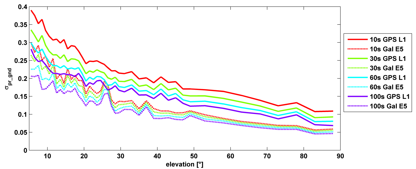
σ(pr_gnd) versus elevation for Galileo E1 (dotted lines) and GPS L1 (solid lines for different smoothing constants: red (10s), green (30s), cyan (60s), purple (100s).
Let’s disregard that question for the time being, and look at some recent research, to be reported in full in the cover story of GPS World magazine’s April issue, out soon. In it, the authors (two German and one American researcher) report:
“Analysis of new Galileo signals at an experimental ground-based augmentation system (GBAS) compares noise and multipath in their performance to GPS L1 and L5. Raw noise and multipath level of the Galileo signals is shown to be smaller than those of GPS. Even after smoothing, Galileo signals perform somewhat better than GPS and are less sensitive to the smoothing time constant.”
This is all pretty arcane and a bit removed from current field of operations, as far as surveyors are concerned. But it does signal something, and it provides food for thought.
The researchers obtained their results using four JAVAD Delta receivers, all connected to Leica AR 25 choke ring antennas.
Fugro has launched the G4 service, designed to provide GNSS augmentation for offshore positioning applications. The new satellite correction service takes advantage of all four GNSS: GPS, GLONASS, BeiDou and Galileo.
By using all available GNSS satellites, Fugro’s G4 service is designed to improve availability and reliability of offshore positioning and thus enhance the safety and productivity of a wide range of survey and other activities offshore. G4 represents a significant advancement compared to augmentation systems which are based on GPS-only or GPS + GLONASS, the company said.
The BeiDou system operated by China currently provides coverage in the Asia-Pacific region. Fugro’s G4 service already utilises the first BeiDou satellites and is ready to start using the Galileo satellites as soon the EU announces Initial Operational Capability (IOC) status for this system. Galileo and future BeiDou satellites will be automatically included as they come online, steadily increasing availability and robustness of the integrated augmentation service.
The new G4 service will be particularly beneficial when the line-of-sight to certain satellites is obstructed by offshore structures – a key consideration during critical positioning operations. The G4 augmentation signals, transmitted via seven high–powered communication satellites to provide at least two independent broadcast channels anywhere in the world, will offer Fugro’s customers unrivalled coverage and availability.
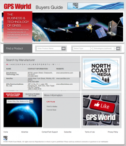
GPS World, the leading publication serving the GNSS Industry, is pleased to announce the industry’s first online buyers guide — gpsworldbuyersguide.com — featuring access to information on hundreds of manufacturers, products and services.
“We’ve taken the GPS World Buyers Guide in print, which we’ve been publishing for 20+ years, to an entirely new level,” said Alan Cameron, editorial director and group publisher of GPS World. “Adding a robust online version offers many benefits to the industry.”
Engineers, integrators, professional end-users and others in search of products and services will continue to have two resources available to them — the print Buyers Guide publishing in June — and the cutting-edge, robust version accessible 24/7 at: gpsworldbuyersguide.com.
Visitors can search for manufacturers by name or location. Products and services are searchable by name or via the following categories:
Vehicle location/tracing workstations and systems (computer-aided dispatch)
These categories are also searchable by sub-categories.
Manufacturers and suppliers are now in control of their listings year-round by having the ability to make listing updates in real time. Listings are free and numerous upgrades are available. Listings found at gpsworldbuyersguide.com will automatically be used to create the print version of the directory.
“GPS World’s new online product offers many economical ways for a manufacturer or supplier to enhance their exposure,” said Steve Copley, GPS World publisher. “We’re excited to offer an online element to our print product and provide a positive experience for users.”
Manufacturers and suppliers are encouraged to review their current listings by using the search functionality found on the directory’s home page. Manufacturers and suppliers not listed in directory are encouraged to create a new listing. All questions relating to the online directory should be directed to Chloe Kalin, Buyers Guide Marketing & Sales Manager, at 216-363-7929.
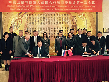
Russia and China have signed a cooperation agreement on satellite navigation, a Russian Space Agency spokesperson told RIA Novosti on Tuesday.
Roscosmos chief Igor Komarov met with Xu Dazhe, the leader of China’s National Space Administration, on an official visit in Beijing.
“The first provision to set up a committee and a protocol were signed during the first working session. Igor Komarov and Xu Dazhe discussed issues of bilateral cooperation in the field of electronic components for rocket construction and building rocket engines,” the spokesperson said.
A Russian-Chinese committee on satellite navigation was established in October 2014 at the meeting between Russia’s Deputy Prime Minister Dmitry Rogozin and his Chinese counterpart, Wang Yang.
In November, China North Industries Corporation (NORINCO) and the Russian GLONASS nonprofit partnership agreed to establish a joint venture to promote worldwide services based on GLONASS and BeiDou.
Russia and China also recently completed joint reconnaissance for the placement of GLONASS differential correction and monitoring stations in the Chinese cities of Urumqi and Changchun. Each country is expected to accommodate three such facilities.
The United Nations and Russia’s space agency ROSCOSMOS are holding a workshop on ways to use GNSS for sustainable social and economic benefits. The workshop will be held May 18-22 in Krasnoyarsk, Russian Federation.
Current and planned projects that use GNSS technology, including the GLObalnaya NAvigatsionnaya Sputnikovaya Sistema (GLONASS) of the Russian Federation, for both practical applications and scientific explorations will be presented. Cooperative efforts and international partnerships for capacity-building, training and research, including the activities of the GLONASS learning center will also be presented.
The workshop program will include plenary sessions described below and also sufficient time for discussions among participants to identify the priority areas where pilot projects should be launched and examine possible partnerships that could be established. In addition, a half-day technical tour will be arranged by the Local Organizing Committee during the workshop.
The workshop is co-organized and co-sponsored by the International Committee on Global Navigation Satellite Systems, and hosted by the Reshetnev Information Satellite Systems Joint Stock Company.
Sessions include:
Session 1: Current and Planned GNSS and Satellite-Based Augmentation Systems
Session 2: GNSS-based Applications
Session 3: GNSS and Space/Atomospheric Weather Monitoring
Session 4: GNSS Reference Frames/Systems and Reference Station Networks
Session 5: Capacity building, training and education in the field of GNSS
Will Be Employable for Surveying, Precise Positioning, and Geodesy
By Peter Steigenberger and André Hauschild, German Aerospace Center (DLR) / German Space Operations Center
The first Full Operational Capability (FOC) Galileo satellite started transmitting L-band navigation signals on November 29, 2014. Based on data collected by a global network of GNSS tracking stations of the Cooperative Network for GNSS Observation (CONGO) and the Multi-GNSS Experiment (MGEX) of the International GNSS Service (IGS), we determined that an E1 signal with pseudorandom noise code (PRN) E18 was first tracked at the station LLAG (La Laguna, Tenerife, Canary Islands) at 06:08 UTC. A few moments later, the satellite’s transmissions were also tracked at other MGEX stations including the E5a, E5b, and E5 AltBOC signals. Based on the computed satellite visibility at various tracking stations, the satellite could be positively identified as GSAT0201, also known as Galileo FOC-FM1 or Galileo 5 with COSPAR ID 2014-050A and NORAD ID 40128.
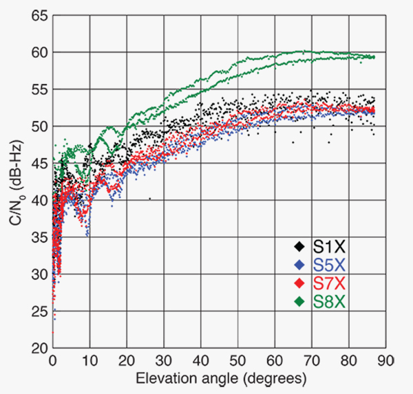
FIGURE 1 shows the carrier-to-noise-density ratio (C/N0) of the E18 signals tracked at the CONGO/MGEX station SIN1 (Singapore, using a Trimble NetR9 receiver with a Leica AR25.3 antenna). We selected the signals from this station for analysis due to an E18 pass occurring close to the zenith and covering almost the full range of elevation angles. The E5a and E5b signals (S5X and S7X RINEX identifiers) show very similar performance, whereas the C/N0 values of the E1 signal are 1–2 dB-Hz higher. The C/N0 values of the E5 AltBOC signal (S8X) reach 60 dB-Hz at high elevation angles, which is about 6 dB-Hz higher than the other signals.
Figure 1. Galileo E18 carrier-to-noise-density ratio for the CONGO/MGEX station SIN1 (Singapore).
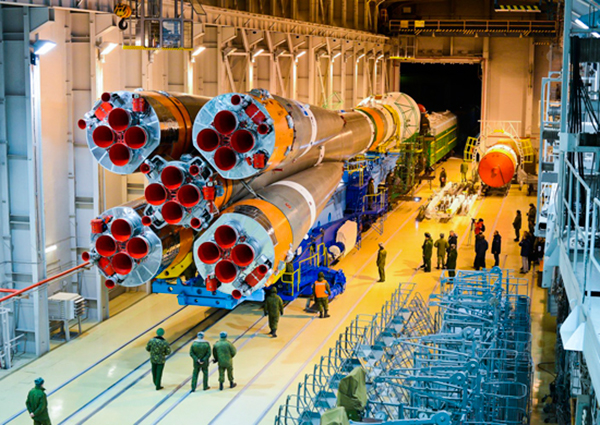
The first pair of Galileo FOC spacecraft was launched on August 22 with a Soyuz launcher from the Guiana Space Centre, Kourou, French Guyana. Due to a malfunction of the Fregat upper stage, the satellites were injected into elliptical orbits with an inclination of about 49° instead of near circular orbits with 55° inclination. In November, the perigee of the first FOC satellite was raised by about 3,500 kilometers by a series of 11 maneuvers with a corresponding reduction in orbit eccentricity from 0.23 to 0.16.
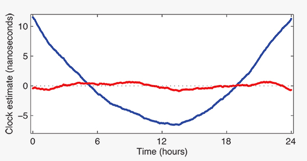
E18 has been included in the precise orbit and clock solutions of the MGEX analysis center at Technische Universität München (TUM) in Munich, Germany, since December 5. FIGURE 2 shows the detrended estimates of the active Galileo E18 clock for December 7. The presence of a pronounced quadratic term as well the large drift of 33.9 microseconds per day indicate that the active clock is a rubidium atomic frequency standard rather than a more precise passive hydrogen maser. The FOC satellites carry two of each kind of clock.
Figure 2. Galileo E18 clock estimates for December 7, 2014, with respect to the hydrogen maser at the Ottawa IGS station (NRC1) after removing an offset and drift (blue) or a second order polynomial (red).
The TUM orbit and clock product allows researchers to again compute dual-frequency positioning solutions using only Galileo observations, as the In-Orbit Validation satellite E20 has not transmitted an E5 signal since May, when a power anomaly left the satellite with the capability to only transmit an E1 signal. Furthermore, E20 currently does not transmit a navigation message.
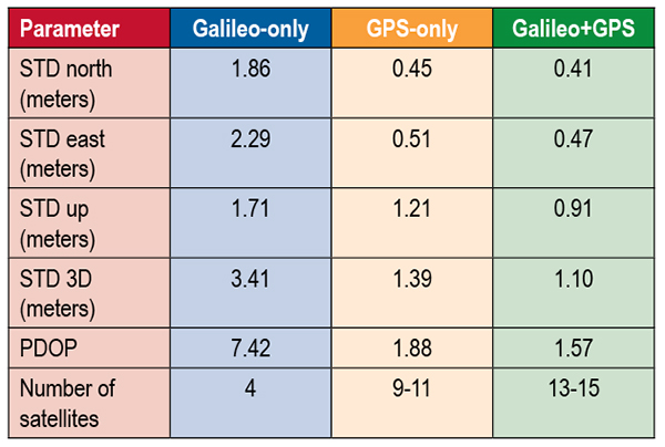
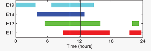
TABLE 1 shows the scatter of single-point positioning using pseudorange (code) observations from the MGEX station MAS1 (Maspalomas, Gran Canaria, Canary Islands) for a Galileo-only, a GPS-only, and a combined Galileo+GPS solution for December 6. At an elevation cut-off angle of 10°, four Galileo satellites were visible from 10:15 until 12:25 UTC (see FIGURE 3). The GPS-only solution covers the same time interval. The start time is not limited by the cut-off angle but an E18 transmission outage from 3:45–10:15 UTC.
TABLE 1. Single point positioning results for the MGEX station MAS1 (Maspalomas) for December 6, 2014.Figure 3. Galileo visibility at the MGEX station MAS1 (Maspalomas) on December 6, 2014. The time period considered in the single-point positioning is indicated by vertical lines.
We used an ionosphere-free linear combination of Galileo E1 and E5 AltBOC code observations and GPS L1 and L2 code observations with a 30-second sampling interval. As the Galileo-only solution suffered from position dilution of precision (PDOP) values of up to 830, a total of 32 epochs with PDOP values greater than 25 were excluded. The geometry of the remaining epochs is still pretty unfavorable. At a mean PDOP value of 7.4, the standalone position solution exhibits a 3D standard deviation (STD) error of 3.4 meters. Use of the Galileo satellites in a combined GPS+ Galileo solution improves the positioning performance. In particular, the height component benefits from the inclusion of the four Galileo satellites with a standard deviation improvement of 25 percent.
Despite the orbit injection error, the new Galileo FOC satellite has now been successfully activated and added to the Galileo constellation. Unfortunately, the current orbit is incompatible with the standard Galileo almanac format, which may cause restrictions for some commercial receiver types.
Nevertheless, the satellite can already be tracked by a wide range of geodetic receivers with existing firmware versions and it will, in fact, be possible to use the new satellite for diverse applications in surveying, precise positioning, and geodesy, as well as in general multi-GNSS studies. We now look forward to the activation of the second FOC satellite, which can be expected in early 2015 and will, for the first time, offer multi-frequency signals from a total of five Galileo satellites.
Sanctions Delay GLONASS-K2
According to Nikolai Testoyedov, the CEO of Information Satellite Systems Reshetnev, manufacturer of the GLONASS satellites, the company will now produce nine GLONASS-K1 satellites.
“For a smooth transition to a multi-functional group and due to issues with the very complex GLONASS-K2 satellites, we decided to continue with the GLONASS-K1 intermediate range of satellites, and we are preparing for the launch of nine units of this series,” he said.
He recalled the original plan was to launch two K1 satellites and then move to GLONASS-K2 satellites.
“In the beginning, really, we wanted after the two GLONASS-K1 satellites No. 11 and 12, to go for the launch of more advanced GLONASS-K2 devices. But, unfortunately, the plans had to be adjusted somewhat because of the sanctions restricting the delivery of radiation-resistant electronic components from the West. We have to put a hold on the in-depth development of technical and technological documentation and that delays us in terms of moving ahead by at least a year or two,”he said.
Reported by the Russian magazine Vestnik GLONASS, and relayed by Richard Langley’s CANSPACE listserv.
GNSS Mandates Would Violate Trade Agreements
A U.S. government representative stated at an international satnav forum that mandating use of specific GNSS services for applications such as air-traffic control, freight shipments, emergency calling, and road tolling could violate the terms of World Trade Organization (WTO) agreements that many nations, including all six GNSS providers, have signed.
Regional mandates already exist for GLONASS in Russia and BeiDou in China, and have been suggested and extensively discussed in Europe, as a way of stimulating the market adoption of Galileo receiver chipsets, thus recouping some of the massive public investment in the satnav system.
The presentation occurred during the Ninth Meeting of the International Committee on Global Navigation Satellite Systems (ICG), held Nov. 10–14, 2014, in Prague, Czech Republic.
Jason Kim, a senior policy analyst at the U.S. Department of Commerce, stated that the United States and the European Union already enjoy a productive dialog on GNSS trade issues under the 2004 U.S.-EU Agreement on GPS-Galileo Cooperation. In that agreement, both parties agreed to consult before establishing GNSS standards, certification requirements, regulations, mandates; affirmed their non-discriminatory approach with respect to GNSS trade; and established a working group to consider non-discrimination and other trade related issues.
Finally, the United States and the European Union recognized and reiterated in 2004 their commitments to WTO rules including those governing technical barriers to trade, specifically, that there would be no goods discrimination based on non-tariff measures such as regulations, standards, testing, or certification.
Kim made the remarks in the course of his presentation titled “GNSS Market Access.” He told GPS World that his presentation was directed less at the European Union, which has been conscientious of its WTO commitments, and more towards the rest of the ICG members, including non-provider nations that may be asked by GNSS providers to mandate specific systems.
“To promote adoption of their systems,” Kim stated, “GNSS providers are considering/implementing equipage mandates for various applications: aviation, motor-carrier and HAZMAT vehicle tracking, car accident reporting (eCall/ERA-GLONASS), and emergency phone calls (E112).
“The United States recommends technology-neutral, performance-based standards,” Kim continued, giving as example the U.S. E911 rules that specify a required positioning accuracy and then allow wireless carriers to choose the best technical solutions according to their lights.
The U.S. government presentation at ICG revealed particular concern that regulations under consideration could adversely affect the sales of U.S. GPS-enabled hardware in many industry sectors. All members of the WTO, including the six GNSS providers on the ICG, are bound to a range of trade agreements designed to promote open-market access, all cited in the Prague ICG presentation: the General Agreement on Tariffs and Trade (GATT), the Agreement on Technical Barriers to Trade (TBT), and the General Agreement on Trade in Services (GATS). The United States, Europe, Japan, and 12 others are also parties to the WTO Agreement on Government Procurement (GPA).
European Commission officials have publicly and recently stated that they are considering how to stimulate Galileo use, in particular through regulatory measures requiring that navigation equipment be installed on aircraft, automobiles, and other platforms.
“Requiring specific systems arbitrarily prevents or penalizes imports of goods having perfectly functional GNSS capability,” said Kim. “WTO members must comply with TBT obligations in setting technical regulations.”
He concluded his presentation by requesting that the ICG Providers’ Forum add GNSS market access to its future agenda for discussion, and consider developing a new principle on market access for future adoption.
According to the GLONASS satellite manufacturer, the company will now produce nine GLONASS-K1 satellites rather than move to GLONASS-K2, because of the sanctions restricting the delivery of radiation-resistant electronic components from the West.
Nikolai Testoyedov, CEO of Information Satellite Systems Reshetnev, told the Russian magazine Vestnik GLONASS, “For a smooth transition to a multi-functional group and due to issues with the very complex GLONASS-K2 satellites, we decided to continue with the GLONASS-K1 intermediate range of satellites, and we are preparing for the launch of nine units of this series.”
He said the original plan was to launch two K1 satellites and then move to GLONASS-K2 satellites.
“In the beginning, really, we wanted after the two GLONASS-K1 satellites No. 11 and 12, to go for the launch of more advanced GLONASS-K2 devices. But, unfortunately, the plans had to be adjusted somewhat because of the sanctions restricting the delivery of radiation-resistant electronic components from the West. We have to put a hold on the in-depth development of technical and technological documentation and that delays us in terms of moving ahead by at least a year or two,”he said.
According to the December 10 issue of Sibirskii Sputnik (Siberian Satellite), the internal newspaper of ISS Reshetnev, the GLONASS-K1 No. 12 satellite (GLONASS 702K) will be brought into service after a six-month test period and replace an existing GLONASS-M satellite, which will subsequently become a reserve satellite.
In news reported by the Russian magazine Vestnik GLONASS, Information Satellite Systems Reshetnev, the manufacturer of the GLONASS satellites, will now produce nine GLONASS-K1 satellites.
“For a smooth transition to a multi-functional group and due to issues with the very complex GLONASS-K2 satellites, we decided to continue with the GLONASS-K1 intermediate range of satellites and we are preparing for the launch of nine units of this series,” said Nikolai Testoyedov, CEO of Information Satellite Systems Reshetnev.
Testoyedov recalled that the original plan was to launch only two GLONASS-K1 satellites and then move on to the GLONASS-K2 satellites. “In the beginning, really, we wanted after the two GLONASS-K1 satellites No. 11 and 12, to go for the launch of more advanced GLONASS-K2 devices. But, unfortunately, the plans had to be adjusted somewhat because of the sanctions restricting the delivery of radiation-resistant electronic components from the West. We have to put a hold on the in-depth development of technical and technological documentation and that delays us in terms of moving ahead by at least a year or two.”


 GPS World, the leading publication serving the GNSS Industry, is pleased to announce the industry’s first online buyers guide —