Iridium Communications Inc. has introduced its Satellite Time and Location (STL) service, an alternative or complement to traditional indoor and outdoor location-based technologies, and declared it ready for use. STL’s position, navigation and timing (PNT) technology is deployed through Iridium’s 66 cross-linked, low-earth orbit satellite constellation.
Through Iridium satellites and in GNSS receivers, STL technology can work to verify GPS, GLONASS, Galileo and other navigation services, and also can serve as an alternative for those services when GPS signals are degraded or unavailable. STL also can provide an alternative source of time when testing GPS signals.
Iridium is working with Satelles, a division of iKare Corporation, as its primary technology partner. Satelles enables Iridium’s paging channels to reach small, low-cost receivers in nearly any environment, the company says in a news release.
“We think STL can help solve an important and growing problem for governments and businesses, and serve as a platform for continued innovation,” says Matt Desch, chief executive officer at Iridium. “With STL, we are introducing a global capability that is already in space, technologically ready for use and is independent of any particular location technology. The team at Satelles has been able to leverage the unique capabilities that our network offers to create a solution that can ultimately be integrated into almost any kind of platform, including other Iridium machine-to-machine devices, heavy machinery, automobiles and even the power grid, to name a few. Once implemented, STL could revolutionize the way the world’s largest, global companies and governments operate and manage cyber security.”
In a chipset about the size of a postage stamp, the technology can be embedded into many devices. STL’s signal strength may make spoofing GPS systems more difficult, the company says. STL transmits its signals through Iridium’s satellite constellation to deliver a unique code to each position on the ground that can be independently authenticated, which allows operation or access only if the user is in the location expected.
“Commercial users are now able to use STL to deliver trustworthy timing solutions for critical infrastructure, such as LTE networks, transactional data centers and the power grid,” says Greg Gutt, president and chief technology officer of Satelles. “Military and government users can also acquire these commercial off-the-shelf solutions for the Department of Defense and other government applications. In addition to enhancing the security and resiliency of GPS, STL technology can be embedded into servers anywhere in the world to geo-fence data and applications, providing trusted time and location data as an independent factor for end-point authentication.”
The STL solution has been successfully demonstrated across multiple sectors, including military, academia and commercial applications. The technology is available today and will be supported by Iridium NEXT, the Iridium’s next-generation global satellite constellation, which is scheduled for completion by late 2017, the company says.
In its 47-year history, Esri has never before built a high-precision GNSS mobile GIS software . Sure, one could connect a high-precision GNSS receiver to ArcGIS Mobile or even ArcGIS desktop running on a tablet, but in those cases and all others, there’s no direct support for high-precision GNSS receivers.
By support, I mean the software features that one needs to automatically collect reliable, verifiable and defensible high-precision GNSS coordinates and associated metadata, like real-time estimated accuracy, correction age and other metadata that can be referenced months or years later to understand the quality of the data collected.
Until now…
Collector for ArcGIS is a cross-platform mobile GIS app that’s available for iOS, Windows 10 and Android. Until now, Collector did not differentiate between low-precision GNSS data (for instance, a smartphone’s internal GNSS receiver) and RTK GNSS (centimeter-accuracy) receivers, so it was difficult to know what sort of accuracy one was achieving even when a centimeter-accurate receiver was connected to it.
Esri is on its way to solving this problem.
Earlier this month, Esri introduced a beta version of the new Collector for ArcGIS mobile GIS software that incorporates features for high-precision GNSS data collection. While Collector has been around for a few years, it has not allowed the user to differentiate between low-precision GNSS data (such as a smartphone internal GNSS receiver) and RTK GNSS (centimeter-accuracy) receivers. To circumvent that limitation, high-precision GNSS receiver vendors offered companion apps that run concurrently with Collector to display metadata. However, that’s not a fun solution because if the user wants to records GNSS metadata, he would have to tab between apps and hand-enter the GNSS metadata into attribute fields in Collector.
Another nagging problem for high-precision GNSS users with Collector is the lack of an on-the-fly datum transformation feature. Sources of high-precision GNSS receiver corrections come in different datum flavors (ITRF08, NAD83/2011, NAD83/CSRS, etc.). Those datum flavors don’t necessarily match a user’s GIS database, sometimes introducing a meter or more of error.
Historically, Collector didn’t give the user an opportunity to apply an on-the-fly datum transformation to reconcile datum differences between the high-precision GNSS receiver datum and the geodatabase datum. Yeah, you could fix it later by applying a datum shift after the fact, but it’s a tedious and laborious task to do so, and sort of defeats the purpose of having an efficient real-time GNSS data collection workflow.
I was using the beta version of iOS Collector for ArcGIS this week with a survey-grade RTK GNSS receiver that, according to GPS World’s2016 Receiver Survey, delivers 1-centimeter RTK accuracy. Setting up the GNSS correction profile is a bit tricky. There are three settings you need to select. Following is a screen capture of the profile settings I used for RTK in Collector when the RTK base was referenced to NAD83/2011:
When setting up a GNSS receiver profile to use WAAS/SBAS as a source of corrections in Collector, you’ll need to select GCS ITRF 2008 instead of GCS NAD 1983 2011.
Once I got the proper datum transformations dialed in, RTK GNSS accuracy was where it should be when compared to a survey mark (3.7mm):
Another tricky area with Collector is the GNSS metadata. It’s great that Collector supports automated GNSS metadata recording, but in order for Collector to record GNSS metadata, you’ll need to follow the Esri data model for GNSS metadata. Essentially, add fields to your database that will be populated. Here’s a link to the supported GNSS metadata fields. http://arcg.is/22h41yR. Note that you’ll need to log in using your Esri account credentials to view the link.
I didn’t add the GNSS metadata fields to the database to try it because this iOS beta version doesn’t support GNSS metadata (Esri says it will be supported on the next beta release), I did collect a bit of data. Here’s what the Collector screen looks like:
Some of the fields on the iPad Mini were cut off (I’ll report that to Esri), but you can see that it is entirely possible for Collector (iOS) to accept and record data from an iPad using an RTK GNSS receiver (note accuracy value at the bottom left corner of the screen.
So, to Esri’s credit, they’ve appeared to address the GNSS metadata and datum transformation problems in the beta release of Collector, making it the first Esri mobile GIS that supports high-precision GNSS. The iOS and Windows 10 beta versions are available now to users who register for Esri’s Collector beta program. For support and answers to questions, you can visit Geonet.
Before you get too excited, even with the new features Collector is still a light-weight mobile GIS and likely always will be, as long as it’s a free app (although not always free to use). But this is certainly a move in the right direction for high-precision GNSS receiver users who want to live in the Esri ArcGIS Online/Portal/Server ecosystem and rid themselves of shp files.
Some of you may beg to differ that Collector is Esri’s first high-precision GNSS mobile GIS data collection software. I know ArcPad has been around for years and has supported high-precision GNSS receivers for many years. In fact, if you install the GeoBullsEye plug-in, ArcPad becomes the only 3D, high-precision GNSS data collection software that works real time in the Esri AGOL/Portal/Server ecosystem. But, it wasn’t built by Esri :-). An Australian company named Maptel built ArcPad, and then Esri acquired the company a few years ago.
While the beta versions of Collector for Windows 10 and iOS are available now, Esri reports that the beta version of Collector for Android should be available next week.
Thanks, and see you next month.
Follow me on Twitter at GPSGIS_Eric
The VN-360 OEM GPS-Compass module provides an accurate, True North heading solution for systems integrators seeking a reliable alternative to magnetic-based sensors to improve the capabilities and performance of next-generation manned and unmanned systems. Unlike digital magnetometers that can be affected by ferrous materials, the VN-360 heading solution provides a cost-effective GPS-based alternative. With two onboard GNSS receivers, the VN-360 calculates the relative position between its two GNSS antennas to derive a heading solution an order of magnitude more accurate than a magnetic compass. It supports a variety of GNSS antennas that can be mounted on the host platform with a separation distance from a few centimeters to several meters. Applications include antenna pointing, multirotor UAVs and aerostats, automated agriculture, heavy machinery, ground robots, weapons training, warfare simulation and direct surveying.
The SDX software-defined GNSS simulator is now available in version 16.2. For real-time kinematic application, it is now possible to synchronize multiple simulators using a 10-MHz reference and pulse-per-second (PPS) signal. Users can modify pseudorange from the graphical user interface or the application program interface (API) in real time. Each satellite can be controlled individually or together. Trajectories can be imported from CSV files, and raw datalogging is improved. The navigation message can be changed in real time during the simulation. There is now an alternative to python API with the C++ open source API (other programming languages, such as C#, will be supported in the future.)
Designed for hydrographic tasks from shallow to deep water
The Apogee-M motion reference unit and the Apogee-U inertial navigation system (INS) are both made of titanium and have a depth rating of 200 meters. The Apogee Series is an accurate INS based on robust micro-electro-mechanical systems (MEMS) technology with a high degree of precision — 0.008 degrees in roll and pitch in real time — while delivering a robust and accurate heading from the continuous fusion of GNSS and IMU data. Apogee-M and Apogee-U are designed to mount close to the sonar head for hydrographic tasks in shallow or deep water. They provide a real-time heave accurate to 5 centimeters, which automatically detects the wave frequency and constantly adjusts to it. When wave frequency is erratic or in case of long-period swell, the delayed heave feature can allow survey in rough conditions with a more extensive calculation, resulting in a heave accurate to 2 cm displayed in real-time with a short delay. Apogee sensors can be paired with any survey-grade GNSS receiver or with one offered by SBG Systems.
The Piksi is a high-performance GPS receiver with real-time kinematic (RTK) functionality for centimeter-level relative positioning accuracy. Designed for integration into autonomous vehicles and portable surveying equipment, it has a fast position-solution update rate and low-power consumption in a small form factor. An open-source architecture with a high-performance digital signal processor on board and a flexible correlation accelerator make it suitable for GNSS research. Features include centimeter-accurate relative positioning (carrier-phase RTK); GPS, GLONASS, Galileo and SBAS signals; 50-Hz position/velocity/time solutions; and integrated patch antenna and external antenna input.
BYOD program offers a range of configurations for a variety of jobs
Anatum Field Solutions (AFS) has launched a nationwide Bring Your Own Device (BYOD) submeter GNSS and centimeter real-time kinematic (RTK ) GNSS receiver rental program. AFS rentals target high-accuracy users in GIS, UAV, environmental, engineering, surveying, agriculture, electric/gas/water utilities, pipeline, forestry, mining, transportation, construction, architecture and government markets. AFS offers all mobile GIS devices including Apple iOS, Android, Windows and Windows Mobile/EHH. It also stocks various GNSS receivers such as Eos Arrow (submeter and centimeter), SXBlue (submeter and centimeter), Trimble R1 (1 meter) and BadElf (1–3 meters) in a variety of configurations.
The FC-5000 field controller, with its 7-inch sunlight-readable display, is designed to provide operators a larger, more versatile and faster handheld computer for the modern construction site. The display has a capacitive touch interface — with finger, glove, small-tip stylus and water-capable options — that is optically bonded to increase visibility. With the press of a key, a user can change the orientation of the screen from portrait to landscape to increase visibility when viewing maps or drawings. The controller is compatible with all Topcon GNSS receivers and total stations, operating MAGNET Field, Site and Layout software. It has two built-in cameras: an 8-MP camera with autofocus and LED flash for field photography, and a 2-MP camera on the front for video meetings. Additional features include 64 GB of flash storage, an optional 4G LTE cellular modem, internal GPS navigation, Bluetooth and Wi-Fi, and a battery life of 10-plus hours.
Phantom 4 features obstacle avoidance, active tracking
The Phantom 4 quadcopter uses advanced computer vision and sensing technology to make professional aerial imaging easier. Its onboard intelligence makes piloting and shooting images easier through features such as its Obstacle Sensing System and ActiveTrack functionality. The Obstacle Sensing System features two forward-facing optical sensors that scan for obstacles and automatically direct the aircraft around impediments, reducing risk of collision, while ensuring flight direction remains constant. Obstacle avoidance also engages if the user triggers the drone’s “Return to Home” function to reduce the risk of collision when automatically flying back to its takeoff point. With ActiveTrack, the user can keep the camera centered on a subject. ActiveTrack allows users running the DJI Go app on iOS and Android devices to follow and keep the camera centered on the subject as it moves by tapping the subject on their smartphone or tablet.
The Pteryx UAV is a photomapping tool designed to help with photogrammetry, land property surveillance, environmental survey, search and rescue, precision agriculture, research, and in the energy sector. With a two-hour flight time, missions can be planned with the endurance reserve needed to overcome the large distances and worst-case changing weather conditions. Pteryx is designed to fly at speeds of about 50 km/h in light or medium wind speeds. The Pteryx can lift up to 1 kilogram of cargo: cameras, camcorders or other research equipment. The payload is housed in a roll-stabilized head on the front of the fuselage. The Pteryx can also accommodate a wide variety of sensors, which are installed in an easy to replace camera head. The Pteryx is delivered with a 16 MPx APS-C (crop sensor) daylight camera and wide lens, with other sensor options available.
The M2-D is a miniature stabilized gyro with electro optical (EO) and infrared imagers. The system is designed for mobile, marine and aerial unmanned applications. The M2-D is compact at 3 inches tall and 2 inches in diameter. The gimbal is fully gyro stabilized and packs sensor technologies previously only available in much larger payloads. The infrared FLIR brand pan-tilt-zoom thermal imaging camera has an optical telephoto zoom in a lightweight 160-gram payload. The high-resolution thermal imaging sensor with digital zoom integration lets users capture stable video in total darkness. For daytime operations, the gimbal has a full-color visual camera with optical 6x zoom to ~4 degrees. The optical zoom is then enhanced with digial zoom integration for stable long-range imaging.
Surveys large areas or objects to generate fast, precise data
Version 2 of the AibotX6 hexacopter features high-precision (HP) GNSS for surveyors. The system also can be installed in existing AibotX6 hexacopters. With Version 2, the precision and quality of surveying data is significantly improved with RTK technology based on the Leica Geosystems SmartNet correction data service. Post-processing is also possible. The new AibotX6 HP GNSS workflow guarantees precision of up to 2-centimeter position accuracy. Besides allowing the use of existing surveying hexacopters, continuing generation and processing of data can be done with the fully integrated software Aibotix AiProFlight. The Aibot X6 can carry a variety of sensors weighing up to 2 kilograms.
Integrates GNSS for challenging maritime positioning
The new DPS 432 combines full decimeter accuracy with high integrity and availability of GNSS data, supporting the safety and efficiency of offshore operations that rely on advanced dynamic positioning (DP) systems. It integrates signals from GPS, GLONASS, BeiDou and Galileo, and regional correction signals including SBAS and G4 services from Fugro, to ensure high flexibility for DP operations globally. Suited to complex operations, the system increases satellite availability, improves integrity monitoring and enables more precision under challenging signal tracking conditions. The DPS 432 features a sophisticated engine that runs in a safe mode protected from unintended user operations.
The aera 660 features a 5-inch capacitive touchscreen display that has been optimized for cockpits and various types of flying. It has a built-in GPS/GLONASS receiver and rich, interactive maps that can be viewed in portrait or landscape modes. Cost-effective database options along with Wi-Fi database updating capabilities allow customers to access up-to-date data, including daily U.S. fuel prices. Bluetooth supports the display of ADS-B in traffic and weather from a variety of sources, including the GDL 39/GDL 39 3D, Flight Stream and the GTX 345 ADS-B transponder. The aera 660 withstands the harshest environments, meeting stringent temperature tests and helicopter vibration standards. Depending on settings and external connections, pilots can receive up to four hours of battery life on a single charge.
At Caltrans District 7 in Los Angeles, we use the onboard GPS capability of smartphones to navigate in real time to the locations of proposed aerial targets and National Geodetic Survey (NGS) control stations.
Keyhole markup language (KML) files are created in the office using desktop GIS, then downloaded to smartphones for use in the field. We create KML files specifically for use by our surveyors during every aerial mapping project within Los Angeles and Ventura counties.
FIGURE 1. Highway Interchange displayed on a smartphone using Google Earth App for Android, (ground targets in blue, flight information for pilots in red and green). Airborne GPS positioning aids in controlling aerial photography as the pilot navigates from exposure to exposure. A flight management system automatically triggers the camera or sensor once it reaches the exposure station in the air.
KML is an extensive markup language (XML) notation for expressing geographic annotation and visualization within Internet-based, two-dimensional maps and three-dimensional Earth browsers. KML was developed for use with Google Earth — originally named Keyhole Earth Viewer.
The aerial target layer also shows the proposed locations of stereo model limits on the smartphone. A stereo model is the overlapping portion of two adjacent aerial images. Each typically has a 60 percent overlap with its adjacent image, so it can be viewed and mapped in stereo. The ground control is combined with the airborne GPS to provide the orientation of the individual exposures, and it establishes the coordinate space of that imagery for any subsequent products.
Having the stereo model limits as a data layer becomes a handy piece of information in the event an aerial target must be relocated because of unfavorable field conditions. The heads-up capabilities of GPS aboard the smartphones and KML files can also show the easiest path to reach either target location or control stations. The NGS control station layer hyperlinks to the NGS website, so the field surveyor always has the recovery note available in an electronic format.
The field surveyors are also given hardcopy maps of the target locations and control stations, but those are now only used as a backup to the KML files loaded onto the smartphones.
FIGURE 2. Phone Screen with station description from NGS database (above).FIGURE 3. The user arrives here via a hyperlink from another screen (FIGURE 2).
We have found that leveraging the onboard GPS capability of smartphones with GIS-based data layers in the field has increased production. Using smartphones provides the surveyors with information more concisely and clearly. This information enables surveyors to make better decisions in the field.
One example is identifying inaccessible areas. If the field surveyor sees that an aerial target can be moved to a different location that provides easier access, it can save time and guesswork.
This information is also valuable in rugged areas because the field surveyor may need to identify the location of hiking trails or while surveying in the desert, or identify the location of aerial targets in areas that are either lightly inhabited or have few landmarks. The project surveyor can tailor datasets specifically to project needed by the field surveyors.
Once the aerial targets have been placed and the NGS control stations recovered, the field surveyors then position the aerial targets and control stations using carrier-phase GNSS. This gives us the centimeter-level accuracy needed to control the aerial photography during our mapping projects.
It happened in the blink of an eye. Less than a blink. Far less, actually. Slightly more than one one-thousandth of an eye blink, according to calculations. In that amount of time, one of your eyelashes traverses 10 micrometers on its journey toward your lower eyelid.
And yet it was long enough to throw computers and communications systems around the world out of whack, generate thousands of alarms, and pull engineers from their beds at 2 a.m.
One occurrence might have been enough to do all that. I’m not sure. But it kept happening over and over again. Thus the alarms, the out-of-whackness, the sleep deprivation. At least it did not generate massive financial trading sell-offs, blow holes in national security, or shut down Facebook, Instagram and Snapchat. For that, we may be thankful.
But it might have.
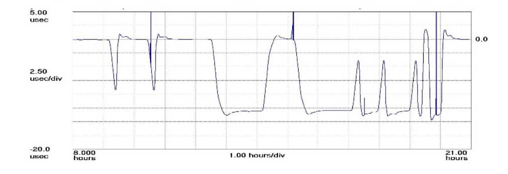
The plot shows how the anomaly event impacted one GPS timing receiver during the day. (Click to enlarge | Chart: Chronos Technology)
“On 26 January at 12:49 a.m. MST, the 2nd Space Operations Squadron at the 50th Space Wing, Schriever Air Force Base, Colo., verified users were experiencing GPS timing issues. Further investigation revealed an issue in the Global Positioning System ground software which only affected the time on legacy L-band signals. This change occurred when the oldest vehicle, SVN 23, was removed from the constellation. While the core navigation systems were working normally, the coordinated universal time timing signal was off by 13 microseconds which exceeded the design specifications. The issue was resolved at 6:10 a.m. MST, however global users may have experienced GPS timing issues for several hours.” (This excerpt from an U.S. Air Force communiqué appears in a brief news account.)
“The Joint Space Operations Center at Vandenberg AFB has not received any reports of issues with GPS-aided munitions, and has determined that the timing error is not attributable to any type of outside interference such as jamming or spoofing. Operator procedures were modified to preclude a repeat of this issue until the ground system software is corrected.”
Companies and their time-servers around the world were subsequently hit by up to 12 hours of system warnings after 15 GPS satellites broadcast the wrong time, according to Chronos, a UK-based time-monitoring firm.
Telecommunications companies constitute only a small part of industry users who rely on the highly precise accuracy of time measurements — supplied by GPS — to control data flow through their networks. Global financial networks and trading markets similarly depend on GPS, as do electrical power grids and many other sectors of critical national infrastructure. These companies and networks invest significantly in highly sophisticated equipment to monitor said timing accuracy as conveyed by GPS signals. Because billions, make that trillions — or actually even more — are riding on it.
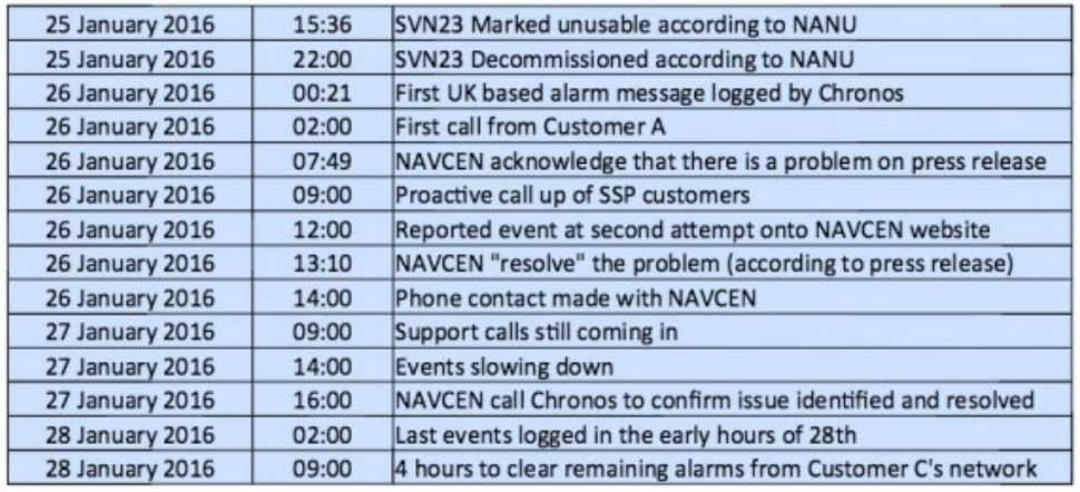
A week after the eye blinks, Chronos Technology released a white paper describing the ensuing fallout for its clients, who are timing equipment users in more than 50 countries around the world. Table 1 from the white paper reports the experience of a few during the event. One company registered nearly 2,500 alarms from its timing equipment during the outage.
Click to enlarge. (Table: Chronos Technology)
At one point during the crisis, according to the white paper, “it appeared that the GPS error had cleared and the Chronos SSP Manager was able to force the units out of holdover. However the scale of the problem escalated as these sites went back into holdover along with dozens of other sites suffering GPS-based timing issues. It was apparent at this point that there was something amiss with the GPS constellation itself.”
Later on, the report states, “This event linked to SVN23 has been one of the most significant service affecting issues for GPS timing users and sits alongside the April 1st 2014 GLONASS outage in scale — however its impact on global timing services is much more extreme.”
Ominously, “Chronos is aware of other more catastrophic impacts to networks and non-telecom applications which were not under supply and support contracts.”
As Loran Is Our Savior. At least one timing-reliant company was not disturbed by the problems, because it was testing an alternative timing service provided by enhanced Loran (eLoran) signals.
Unfortunately for them — and for the rest of us — eLoran has a very uncertain future. In fact, they were lucky to have an eLoran signal at all on January 26, because it was supposed to have been turned off on December 31. Somebody must have forgotten to tell the operators at the Anthorn giant antenna field in Cumbria to go home.
France, Norway, and the United Kingdom, three countries that had been keeping eLoran alive, officially abandoned the effort at the end of last year, reportedly because of lack of leadership from the United States.
The U.S. government decommissioned all its Loran stations a few years ago, even going to the extent of blowing some of them up (perhaps to prevent them from falling into the hands of subversives). Despite a recent reinvigorated interest in enhanced Loran technology, it may be too little, too late.
Whoa, Nellie. The first recorded use of the term “back-up technology” occurred in 1892, when farmers were urged not to prematurely abandon their mules in favor of John Froehlich’s new gasoline tractor.
Dan Albone on his prototype Ivel Agricultural motor. (Image: North Bedfordshire Gazette, 1903)
That admonition, however prudent, has since passed from view. But the concept remains sound. It has surfaced many, many times in GPS World magazine. Certainly not the first incidence, but the farthest back that I can retrieve via search on our website, came in 2007 from Defense contributing editor Don Jewell. “Why do we need a backup? Here is a classic case in point.” He describes a Joint Navigation Conference briefing on a surprise jamming incident that had occurred in January of that year.
In 2009, we reported on an Independent Assessment Team (IAT) report that “unanimously recommends that the U.S. government complete the eLoran upgrade and commit to eLoran as the national backup to GPS for 20 years.” The report was written in 2007, but quashed by the Department of Transportation and Department of Homeland Security (DHS) Executive Committees that commissioned it. Its public release came only after an extensive Freedom Of Information Act (FOIA) battle.
The U.S. government proceeded, despite its paid experts’ recommendations, to blow up those old Loran stations. The current renewed interest and the Wildwood experiment are worthy — more than worthy. Can they prevail? Can they survive blind reliance on a single string of vulnerable technology?
Indubitably, the critical role of GPS back-up was advanced prior to 2007, I just can’t document it this morning by deadline. For the sake of argument, let’s take April 12, 2007, as our start.
We are now 3,229 days out. That’s 77,496 hours, or nearly 279 million seconds. Correct me if wrong, but that appears to make 21.5 million-million times the length of January’s GPS timing error. Surely sufficient to blink a few times, scratch one’s head, and wonder.
The President’s Budget for Fiscal Year 2017 includes $847.362 million in Department of Defense funds and $10 million in Department of Transportation funds to sustain and modernize the Global Positioning System (GPS).
Funds will go toward the GPS III program, including the new ground system (OCX), military user equipment, and wide-area augmentation through the Federal Aviation Administration (FAA).
By national policy, DOT provides resources to DOD for assessment, development, acquisition, implementation, operation, and sustainment of additional designated GPS civil capabilities beyond the second and third civil signals. In addition, the DOT budget includes the following GPS augmentations and activities.
Space maps of some of 13,986 satellites, below, and some navigation satellites, above (courtesy Esri).Alan Cameron
Advocacy in the U.S. capital urges augmentation of GPS/GNSS with eLoran and other “complementary terrestrial PNT services to increase resilience.” See the Resilient Navigation and Timing Foundation’s website, rntfnd.org. This is assuredly a good thing, a worthy cause.
I’ve come to believe, however, that true resilience goes beyond what we normally think of as position and timing sensors. Stimulus comes from a keynote lecture by Dawn Wright, Esri chief scientist, at the 2015 American Geophysical Union Fall Meeting. I hope Esri or the AGU will publish the lecture or post the video. For now, bear with my limited rendition.
In “Toward a Digital Resilience, with a Dash of Location Enlightenment,” Wright describes the new science of big data: the flood of info from satellites, sensors and other measuring systems; the issues inherent in large data sets; and the insight discovered through their manipulation and exploration. She talks to geographic information systems professionals, software makers and users, but her remarks resonate beyond that associated industry sector and well into that of PNT hardware, where we live.
Integrate, integrate, integrate! Interoperability and crosswalking with other systems and data sets. To make it reproducible, make it virtual — as in virtual, living journals. These are three of the eight ideas toward digital resilience that she espouses, making communities more resilient with tools and data.
I’ll return to this in a later editorial; there’s much around which still to wrap my head. But here’s the moral: resilient PNT will ultimately mean more than complementary sensors. It will entail a seamless mesh of hardware and software, of pre-existing and new data, much of it from sources we don’t currently consider PNT-relevant, of input from amateur app makers and users and more.
By 50th Space Wing Public Affairs, Schriever Air Force Base
Throughout the years, GPS has achieved historic milestones and garnered recognition for its contributions to the betterment of humanity.
2015 was no different.
Photo: 50th Space Wing Public Affairs, Schriever Air Force Base
GPS, operated by the dedicated men and women of the 2nd and 19th Space Operations Squadrons at Schriever Air Force Base, Colorado, is also the world’s largest military satellite constellation. Uses of GPS include precise timing for financial transactions, search and rescue, communications, farming, recreation and both military and commercial aviation.
The 2 and 19 SOPS, referred to as Team Black Jack, hosted GPS Week Feb. 15-20 to honor their heritage and interact directly with the Colorado Springs community. The week included a community geo-caching event, GPS/base tours for dozens of middle and high school students, 2 SOPS educational outreach events at local schools and culminated with a GPS heritage celebration.
“We wanted to touch the different facets of our community and that’s why we planned these events,” said Tech. Sgt. Abifarin Scott, 2 SOPS GPS maintenance flight chief.
GPS received historic recognition from the city of Colorado Springs a few months later.
Colorado Springs City Council members presented a proclamation declaring July 17, 2015, GPS Day during a ceremony July 15.
“It’s a great time, a significant milestone that [GPS] has been active this long,” said Andy Pico, Colorado Springs City Council member. “GPS has grown to be such a tremendous part of everybody’s lives, it runs everything…it’s so much into the fabric of everybody’s life.”
The proclamation came as the Air Force celebrated GPS’s 20 years of full operational capability, confirmed July 17, 1995. During the last 20 years, GPS has become an integral part of technology that affects the lives of billions of people around the world.
The men and women of GPS stayed busy supporting many operations throughout the year.
GPS IIF-10. (Photo: ULA)
The Air Force and the 45th Space Wing supported the successful launch of a United Launch Alliance Delta IV rocket that roared to life March 25, carrying the Air Force’s ninth Block IIF-09 navigation satellite for the GPS.
2 and 19 SOPS accepted satellite control authority of GPS IIF-9 Satellite Vehicle Number-71 April 3.
2 SOPS successfully completed a transfer operation of GPS satellite control authority to the Alternate Master Control Site at a backup location on June 6.
2 and 19 SOPS accepted command and control of the 10th GPS Block IIF satellite July 24.
After 15 years of launch operations for the GPS, 19 SOPS completed their 26th launch as a squadron Oct. 31, performing checkout operations on the 11th GPS IIF satellite.
On Nov. 6, Team Black Jack accepted SCA just six days after the Halloween launch of satellite vehicle number-73 – in record time. Members of Team Black Jack prepped for the launch and subsequent SCA acceptance of SVN-73 for approximately three months.
The Command’s GPS operations were showcased in multiple venues this year, engaging with communities and making the mission known all over the world.
CBS featured the 50th Space Wing and GPS on an episode of 60 Minutes, and BLUE, the Air Force’s flagship TV show, also featured GPS — both of which displayed the capabilities it offers to humanity.
Beyond its essential capability for the military, GPS is a worldwide utility that provides the highest accuracy data available to people all around the world and enables such vital activities as weather forecasting, transportation, global commerce and farming/agriculture.
“2 SOPS’s continuing objective is to ensure GPS remains the gold standard for global space-based navigation and timing by providing highly reliable and accurate GPS signals to users around the world,” said Lt. Col. Todd Benson, 2 SOPS Commander. “We look forward to continuing to provide our mission partners and global users with the most accurate position, navigation and timing signal available in the history of GPS.”
The Smart Energy Catalyst. The project showcased how a smart home, smart electric vehicle and smart energy system can work together in an IoT ecosystem with location as a key interaction point.
Geospatial technology company Esri was honored at the TM Forum Catalyst InFocus event for the company’s contributions to developing solutions for a more connected world. TM Forum, a global industry association for digital business, presented Esri and partners with the Most Innovative Catalyst Award.
“We’re driving toward the ultimate Internet of Things (IoT) ecosystem where you can bring different applications together that are going to make our lives safer, more energy efficient, and much better in the future,” said Randy Frantz, telecommunications solutions director at Esri.
Esri’s telecommunications team collaborated with Orange and BearingPoint on the award-winning proof-of-concept project called the Smart Energy Catalyst. The project showcased how a smart home, smart electric vehicle and smart energy system can work together in an IoT ecosystem with location as a key interaction point.
The multiphase project examined the infrastructure necessary to support a smart energy ecosystem. With the latest iteration of the Catalyst, the project team demonstrated how geofencing in homes and cars can work with Esri’s geographic information system (GIS) technology. When the consumer leaves home or work, mobile devices trigger the GIS to initiate a series of notifications and actions. For example, lights in homes automatically turn off, security systems are enabled, and users are notified that their electric vehicle needs charging.
“Location provides context to the IoT network. It transforms raw sensor data into useful, actionable information,” Frantz said.
TM Forum’s Strategy Committee gave the award to the Smart Energy Catalyst team based on several criteria, including having a compelling and inspiring demonstration; growth potential and business value; and potential for humanitarian or other positive effects on society.
Nearly 200 industry leaders attended the Catalyst InFocus conference, where they explored the organization’s 11 project demonstrations.
TM Forum’s Catalyst program connects diverse companies from across industries, facilitating collaboration and fostering the cocreation of innovative solutions to pressing telecommunications business challenges. Catalysts are member-led projects and demonstrations that both inform and leverage TM Forum best practices and standards including TM Forum Frameworx.
The organization announces Catalyst Awards biannually. Winning teams leverage proven technologies, competencies, and investments. Teams have six months to develop proofs of concept that outline digital solutions.
In addition to his work on the Smart Energy Catalyst, Frantz accepted a position earlier this year as colead of TM Forum’s IoT work stream. The endeavor explores how location, advanced sensor and device data, and powerful industrial and consumer solutions can change social norms and bring business into the modern technology framework.
TM Forum includes more than 900 member organizations and 85,000 individual members.
Question: What is the optimum number of GNSS signals to include/process in a consumer-grade PNT device?
Philip Mattos Receiver Designer Consultant
A: A chip should support four signals, being GPS/GLONASS/Galileo/Beidou, but only process two of them — choice depending on region, geopolitical sensitivity, constellation availability — dropping to one to save power when satellite availability is good. Two constellations give enough satellites for accuracy and availability in obstructed environments. Which two depends on needs regarding cost, power and so on, GPS and Galileo being better in the future for less power, but GPS and GLONASS being better today.
Greg Turetzky
Principal Engineer
Intel
A: The receiver should be capable of processing sufficient signals to provide optimum performance in all expected use cases. This means it should be able to support all GNSS and augmentation systems to provide maximum robustness to blockages and interference. The management of receiver resources to accomplish that is highly dynamic on individual epochs and should be invisible to the user in consumer-grade devices. Optimizing tradeoff between performance, power and cost is where the secret sauce lies.
Ruslan Budnik CEO SPIRIT Navigation
A: Two constellations give reliable, fast cold start even after long overseas flights. There is room for improvement in challenging conditions, so application of three constellations is the saturation point. Choose the best combination in different parts of the globe. In Russia that should be GLONASS + 2, in China BeiDou + 2, in Europe Galileo plus two, GPS + QZSS + another one in Japan, and so on. Navigation chipmakers should support all operating satnav systems to offer the best combination, taking into account battery drain.
GPS-guided cruise control is now in production for new models of Kenworth long-haul trucks that have the Paccar MX-13 engine.
By anticipating the terrain ahead using GPS, Kenworth Predictive Cruise Control delivers optimal fuel economy by ensuring the engine and transmission are in the most efficient operating mode.
The system is available as a factory-installed option.
CLEVELAND, Ohio — November 18, 2015 — GPS World relaunched this week with a redesigned print magazine and website, GPSWorld.com. Both feature a new logo, new design and widened coverage.
The GPS World brand has expanded its technical coverage to include all GNSS and Position, Navigation & Timing (PNT) solutions, trends and applications.
“We celebrated GPS World’s 25th anniversary in 2014 by embarking on the brand’s most-comprehensive research project to date,” said Kevin Stoltman, president and CEO of Cleveland-based North Coast Media, GPS World’s parent company.
The GPS World team conducted a research project and used a rebranding/repositioning expert to help better serve its industry-leading family of readers and marketing partners for decades to come.
“After months of comprehensive focus groups and surveys, we discovered readers and advertisers across the globe are fiercely loyal to GPS World,” Stoltman adds. “They love what we do, the information we offer. They just crave more of it: They want us to cover all GNSS and PNT technologies, trends and applications — and that’s exactly what we’re doing now, across all media platforms: print, digital and events.”
GPS World November 2015
The new GPS World publication also features a six-fold increase in segment-specific technical coverage — GNSS/PNT trends, obstacles and opportunities related to: Survey, Mapping, OEM, unmanned autonomous vehicles (UAVs), Defense, Mobile, Transportation and Machine Control. Those increase in segments also are reflected on GPSWorld.com.
“GNSS — and GPS as its leading element — remains at the core of all that we and the industry do,” said Alan Cameron, editor-in-chief and publisher of GPS World. “But it has become abundantly clear that to deliver the everywhere-everytime solution, GPS/GNSS require augmentation, back-up and alternatives. This is the promise of the future for UAVs, critical infrastructure, defense, machine control, surveying, construction and countless other fields: a consistent, highly accurate PNT solution at all times. Our new brand and expanded coverage represent our commitment to the industry in pursuit of this goal.”
The new website features a mobile-responsive design as well as new opportunities for website sponsorship with the Platinum Website Sponsorship option.
About GPS World
Founded in 1990, GPS World has an independently audited total unduplicated reach of 70,650 — delivering the largest audience in the industry. The B2B media brand publishes nine e-newsletters with a combined readership of more than 113,000, and conducts monthly technical webinars for engineers. Its website, GPSWorld.com, draws an industry-dominant 650,000 visitors and 1.5 million page views annually. (Source: June 2015 Verified Audit Circulation Annual Audit Report)
For more information on advertising or sponsorship opportunities with GPS World, please contact International Account Manager Michelle Mitchell at [email protected] or 216-363-7922.
GPS World is published by North Coast Media LLC, the largest B2B publishing company headquartered in Cleveland. NCM’s flagship brands include LP Gas, Pit & Quarry, GPS World, Pest Management Professional, Landscape Management and Golfdom. Ancillary brands include Portable Plants & Equipment, Geospatial Solutions, Athletic Turf, Truman’s Scientific Guide to Pest Management Operations and a host of other leading industry reference books.