MemSQL, which specializes in real-time databases for transactions and analytics, has announced new geospatial capabilities for its in-memory, distributed SQL-based database. By bringing together geospatial and operational data in the same high speed database, customers can achieve unprecedented agility for geospatial analysis, MemSQL said.
Unlike segregated solutions, MemSQL integrates geospatial data as a primary data type, making it as easy to use and operate at scale with as much speed and high throughput as any other class of data.
Previously, enterprises were forced to segregate their geospatial data into separate data stores. With the rise of IoT and mobility, nearly all data is location-specific. As data volume increases, maintaining geolocation information outside of the primary datastore leads to longer latency and synchronization challenges.
By integrating geospatial functions, MemSQL enables enterprises to achieve greater database efficiency with a single database that is in-memory, linearly scalable and supports the full range of relational SQL and geospatial functions. With MemSQL, geospatial data no longer remains separate and becomes just another data type with lock-free capabilities and powerful manipulation functions.
Taxi Scenario with Esri.Working with MemSQL and Apache Spark, Esri analyzed data compiled from 170 million real-world New York City taxi rides around the GPS coordinates of pickups and dropoffs, as well as distance and travel time. Slicing by hour of the day, Esri can calculate the average speed of a taxi ride and find the best and worst places for traffic jams. Slicing by day of the week, the ebb and flow of traffic during workdays and weekends becomes visible.
For a city planner, this data insight can be used to redirect traffic at specific times in an effort to unclog traffic congestion. For the taxi business, this data can improve efficiency with supply and demand of cabs during times of high or low traffic for any given region.
“MemSQL is enabling companies to consolidate many niche solutions into fewer, more capable multi-purpose solutions. By making geospatial data a primary part of in-memory, operational databases, our customers can rely on one solution to make their data more valuable,” said Eric Frenkiel, MemSQL co-founder and CEO. “We’re delivering on our promise of easy access to database innovation and are quickly becoming the go-to-company to help enterprises operationalize analytics.”
MemSQL will showcase the MemSQL, Apache Spark and Esri demonstration at Spark Summit East 2015 on March 18-19 at The Sheraton New York Times Square Hotel. Visit MemSQL at Booth 13 during show expo hours.
The early access MemSQL geospatial capabilities are available now and will be generally available in calendar Q2. Read the technical blog post here.
Pocket Systems Ltd. has released PocketGIS for Android. PocketGIS is a professional mobile geographical information system for field data capture and surveying, which can capture and edit map geometry and enter data using forms.
PocketGIS runs on Android 4.0 and later and is designed for tablet and handheld screens.
GPS/GNSS. PocketGIS can be linked to a device’s internal GPS or GNSS receiver, or an external receiver via Bluetooth. This provides real-time location tracking and data capture. The GPS position is projected to the chosen coordinate system in real time offering instant verification of survey results.
The GPS trail function specifies a time or distance interval to automatically create points from the current GPS position. This let’s users capture points automatically while walking a line or route. Advanced settings allow filtering of GPS quality to ensure the accuracy of captured points. Users can also take an average of a number for GPS position readings and compensate for antenna heights. National grid datum corrections are supported, and these are added on request (such as OSTN02, ETRS89, RH2000 and OSGM02).
PocketGIS can be connected to a laser rangefinder or total station and provides a comprehensive set of laser survey functions. The laser functions integrate with GPS to survey offset positions and calculate height differences. Photographs can be taken from within the data-collection form using the device’s built-in camera to link the picture to captured points, lines or areas.
Edit, Measure, Search. Users can tap on points, lines areas or text (features) to display and update information. Users can measure distances or areas and display grid references, move points and edit lines, and search for data by type or value.
Data Exchange. PocketGIS can import and export data from cloud services such as Dropbox or Google Drive or via email. Shape, Comma Separated Values (CSV) and TIFF raster are supported. Additional formats will be supported in the future. Users can specify capture features, design data capture forms and customize imported data from within the application. No additional software or servers are required.
PocketGIS was first released in 1997 or the Newton MessagePad. Having run on a succession of Windows CE devices, PocketGIS has evolved again and is now available for Android.
Veripos, a supplier of high-precision GNSS positioning facilities to offshore and associated industries, has upgraded its Apex and Apex² precise point positioning (PPP) services.
The services now typically provide users with a horizontal position accuracy of better than 5 cm and 12 cm in the vertical at the two sigma (95 percent) confidence level.
The enhanced levels of performance, now available to all current users of Apex and Apex² without any need to upgrade, have been calculated from static data obtained in Aberdeen, Scotland, where Veripos is headquartered, as well as Houston, Texas, and Singapore. Veripos said that accuracies may vary with observing conditions, however.
The improved accuracy follows a major upgrade of the entire Veripos global reference station network for tracking all GNSS signals, together with introduction of new receivers and geodetic antennas for delivery of better measurement quality resulting from refinements to algorithms and software used to derive necessary GNSS orbit and clock corrections.
Designed to meet all offshore positioning and navigation applications, the dual-beam Apex and Apex² PPP services are relayed via seven geostationary communications satellites to ensure continuous availability and service redundancy while providing access to both GPS and GLONASS constellations. Positional accuracy is maintained regardless of user location, Veripos said.
GIS software provider Supergeo will release an NTRIP solution on SuperPad, its Windows Mobile GIS app, for high-accuracy field data collection and geospatial workflow enhancement.
SuperPad is a feature-rich mobile GIS application for field-based personnel to collect, edit, display and measure spatial data. The flexible development environment and customized extensions enable users to create a custom platform. SuperPad supports synchronizing data with an enterprise’s server to improve efficiency.
SuperPad version 3.3 will support an NTRIP solution with RTK technology. Real-time kinematic (RTK) satellite navigation, one of the latest and widely used technologies within the field of differential GNSS, significantly enhances the precision of the positioning data. RTK positioning can raise accuracy to the centimeter-level.
With the NTRIP solution, SuperPad is not only be capable of handling post-process DGNSS workflow, but also allows users to connect to network RTK service providers with NTRIP protocol, such as a virtual reference station RTK service provider or private station services. Its operations for turning on the module and quick-to-use settings will save surveyors time, while supporting GNSS receivers from makers such as u-blox, Hemisphere GNSS and NovAtel.
Progress of the SuperPad NTRIP Extension is also visualized as a condition monitoring informer on the map intuitively. Users looking for high accuracy or precision status with the RTK correction will find more details about the fixing mode and GNSS information presented clearly with the renewed GPS Status pages.
Trimble, together with its distribution partner Ultimate Positioning Group (UPG), announced the availability of Trimble VRS Now correction service in Queensland, New South Wales, South Australia, Tasmania and Victoria.
Trimble is also now offering the Trimble VRS Now correction service in Oregon’s Willamette Valley.
The commercial subscription service provides surveyors, civil engineers, geospatial professionals and other industry specialists in these areas with instant access to real-time kinematic (RTK) GNSS corrections without the need for a base station.
Using both GPS and GLONASS constellations, the Trimble service delivers centimeter-level RTK corrections customized for each GNSS receiver’s location anywhere in the network via cellular communications. The Trimble VRS Now service supplies accurate, reliable and easy-to-use GNSS positioning for a variety of applications including surveying, urban planning, urban and rural construction, environmental monitoring, resource and territory management, disaster prevention and relief and scientific research, Trimble said.
“The addition of VRS Now to Trimble’s current portfolio of corrections technologies and services in Australia highlights our ability to meet any accuracy, delivery, availability and financial consideration across a variety of applications and markets,” said John Sprivulis, business area director of Trimble’s Positioning Services Division in the Asia Pacific. “Trimble is effectively creating a national positioning infrastructure to meet Australia’s future needs.”
Trimble VRS Now in Australia is a continuation of Trimble’s focus on providing solutions that enable customers to increase productivity by simplifying access to high-precision accuracy around the world. Similar VRS Now services are operating in parts of the U.S. and Europe.
In addition, the Australian VRS Now service supports the Trimble Pivot Field Mobile App, which provides up-to-the-minute information on the VRS Now system status for users in the region.
Because OmniSTAR CORS service in the area is being phased out, existing Australian users will be automatically transitioned to the Trimble VRS Now service, which provides easy access to high accuracy and reliable positioning within the network coverage area.
Service in Australia and Oregon is a continuation of Trimble’s focus on providing solutions that enable customers to increase productivity by simplifying access to high-precision positioning around the world. Similar VRS Now services are operating in Illinois, Indiana, Iowa, Nebraska, Colorado, Florida, Alabama, Mississippi, Texas, and parts of Europe.
The new ASPRS accuracy standards fill a critical need for map users and map makers alike. For centuries, map scale and contour interval have been used as an indication of map accuracy. Users want to know how accurately they can measure different things on a map, and map makers want to know how accurate maps need to be in order to satisfy user requirements. Those contracting for new maps depend on some form of map accuracy standard to evaluate the tradeoff between the accuracy required vs. how much time and expense are justified in achieving it, and then to describe the accuracy of the result in a uniform way that is reliable, defensible, and repeatable, ASPRS explains in a statement.
The new ASPRS standards address recent innovations in digital imaging and non-imaging sensors, airborne GPS, inertial measurement units (IMU) and aerial triangulation (AT) technologies. Unlike prior standards, the new standards are independent of scale and contour interval, they address higher levels of accuracies achievable by the latest technologies (such as unmanned aerial systems and LiDAR mobile mapping systems), and they provide enough flexibility to be applicable to future technologies as they are developed. Finally, the new standards provide cross references to older standards, as well as detailed guidance for a wide range of potential applications.
No prior U.S. accuracy standard comprehensively addresses the current state of mapping technology, which is why the new ASPRS standards were developed. The National Map Accuracy Standards (NMAS), developed in 1947, are still used because they are simple, but there is no scientific correlation between those standards and current mapping methodologies.
The ASPRS 1990 Standards were an improvement over NMAS; however, they did not do well in representing the capabilities of LiDAR, orthoimagery, digital mapping cameras or other current technologies in wide-spread use today.
The National Standard for Spatial Data Accuracy (NSSDA) is a reporting standard that references the old ASPRS 1990 standards and is cross-referenced in the new ASPRS standards. NSSDA provides no accuracy thresholds and does not by itself provide any new or updated guidance on how to select or specify an appropriate accuracy for intended applications.
The new ASPRS standards were developed by the ASPRS Map Accuracy Standards Working Group, a joint committee under the Photogrammetric Applications Division, Primary Data Acquisition Division and LiDAR Division, which was formed for the purpose of reviewing and updating ASPRS map accuracy standards to reflect current technologies. A subcommittee of this group, consisting of Qassim Abdullah, David Maune, Doug Smith, and Hans Karl Heidemann, was responsible for drafting the document.
Draft versions of the standard underwent extensive review, both within ASPRS as well as through public review by other key geospatial mapping organizations, prior to final approval by the ASPRS Board of Directors on November 17, 2014.
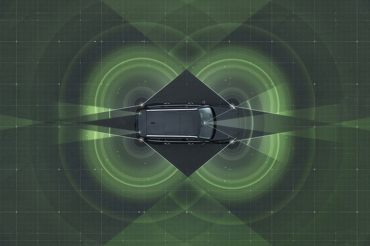
Volvo Cars has a complete system solution that makes it possible to integrate self-driving cars into real traffic, with ordinary people in the driver’s seat. The automaker presented its planned system in an online press conference Feb. 19.
“We are entering uncharted territory in the field of autonomous driving,” said Peter Mertens, senior vice president of Research and Development, Volvo Car Group. “Taking the exciting step to a public pilot, with the ambition to enable ordinary people to sit behind the wheel in normal traffic on public roads, has never been done before.”
As the Drive Me project enters its second year, Volvo is moving toward its goal of placing 100 self-driving cars in the hands of customers on selected roads around Gothenburg by 2017. The public pilot — a collaboration between legislators, transport authorities, a major city and a vehicle manufacturer — is a central component of Volvo’s plan to achieve sustainable mobility and ensure a crash-free future.
Early prototype cars are now being tested on the DriveMe route in and around Gothenburg, Sweden.
Volvo’s production-viable autonomous driving system is based on a complex network of sensors, cloud-based positioning systems and intelligent braking and steering technologies.
“Autonomous driving will fundamentally change the way we look at driving. In the future, you will be able to choose between autonomous and active driving,” Mertens said. “This transforms everyday commuting from lost time to quality time, opening up new opportunities for work and pleasure.”
Volvo’s autopilot system is designed to be reliable enough to allow the car to take over every aspect of driving in autonomous mode, Volvo said. The technology advances a crucial step beyond the automotive systems demonstrated so far since it includes fault-tolerant systems, the carmaker said.
“It is relatively easy to build and demonstrate a self-driving concept vehicle, but if you want to create an impact in the real world, you have to design and produce a complete system that will be safe, robust and affordable for ordinary customers,” said Erik Coelingh, technical specialist at Volvo Cars.
The main challenge is to design an autopilot that is robust for traffic scenarios as well as for technical faults that may occur. The driver can’t be expected to suddenly intervene in a critical situation. Initially, the cars will drive autonomously on selected roads with suitable conditions, such as without oncoming traffic, cyclists or pedestrians.
Volvo’s system generates exact positioning and a complete 360° view of the car’s surroundings through a combination of radars, cameras and laser sensors. A network of computers processes the information, generating a real-time map of moving and stationary objects in the environment.
“Making this complex system 99 percent reliable is not good enough. You need to get much closer to 100 percent before you can let self-driving cars mix with other road users in real-life traffic,” Coelingh said. “Here, we have a similar approach to that of the aircraft industry. Our fail-operational architecture includes backup systems that will ensure that the autopilot will continue to function safely if an element of the system were to become disabled.”
For example, the probability of a brake system failure is very small, but a self-driving vehicle needs a second independent system to brake the vehicle to a stop, because it is unlikely that the driver will be prepared to press the brake pedal.
On the road, the complete technology solution is designed to handle even the most complicated scenarios, from smooth commuting to heavy traffic and emergency situations, Volvo said. “Just as good drivers would, potentially critical situations are approached with sensible caution. In a real emergency, however, the car reacts faster than most humans,” Coelingh said.
When autonomous driving is no longer available — because of weather, technical malfunction or the end of the route has been reached — the driver is prompted by the system to take over again. If the driver is incapacitated for any reason and does not take over in time, the car will bring itself to a safe place to stop.
Volvo expects that autonomous driving could cut fuel consumption, improve traffic flow, and open up possibilities for urban planning and more cost-efficient investments in infrastructure.
“Developing a complete technological solution for self-driving cars is a major step. Once the public pilot is up and running, it will provide us with valuable knowledge about implementing self-driving cars in the traffic environment, and help us explore how they can contribute to sustainable mobility,” Coelingh said. “Our smart vehicles are a key part of the solution, but a broad societal approach is vital to offer sustainable personal mobility in the future. This unique cross-functional cooperation is the key to a successful implementation of self-driving vehicles.”
Drive Me system components:
The 76-GHz frequency-modulated, continuous wave radar is placed in the windscreen and combined with a camera to detect objects on the road. Four radars behind the front and rear bumpers locate objects in all directions. Long-range radars in the rear ensure a good rearward detection of vehicles in parallel lanes.
Sensor technologies. Volvo Cars is developing a holistic solution that generates exact positioning and a complete 360-degree view of the car’s surroundings. This is achieved by a combination of multiple radars, cameras and laser sensors. A redundant network of computers processes the information, generating a real-time map of moving and stationary objects in the environment.
Precise positioning is based on this surround information together with GPS and a high-definition 3D digital map that is continuously updated with real-time data. The system is reliable enough to work without requiring driver supervision.
Combined radar and camera. The combined 76-GHz frequency-modulated continuous wave radar and camera placed in the windscreen is the same as that in the new XC90. This system reads traffic signs and the road’s curvature and can detect objects on the road such as other road users.
Surround radars. Four radars behind the front and rear bumpers (one on each corner of the car) are able to locate objects in all directions. By sweeping both left and right, transmitting waves that bounce off signs, poles, and tunnels, they monitor a full 360-degree around the car.
360-degree surround vision. Four cameras monitor objects in close proximity to the vehicle. Two are under the outer rear-view mirrors, one is in the rear bumper and one is in the grille. Besides detecting objects at close range, these cameras monitor lane markings. The cameras have a high dynamic range and can handle quick changes in lightning conditions, such as when entering a tunnel.
Multiple beam laser scanner. This sensor system is placed in the front of the vehicle, below the air intake. The scanner can identify objects in front of the car and ensures very high angle resolution. It can also distinguish between objects. The laser sensor has a range of 150 meters for vehicles and covers a 140-degree field of view.
Trifocal camera. A trifocal camera placed behind the upper part of the windscreen is three cameras in one, providing a broad 140-degree view, a 45-degree view and a long-range, yet narrow, 34-degree view for improved depth perception and distant-object detection. The camera can spot suddenly appearing pedestrians and other unexpected road hazards.
Long-range radars. Two long-range radars placed in the rear bumper of the car ensure a good rearward field of view. This technology is useful when changing lanes because it can detect fast-moving vehicles approaching from far behind.
Ultrasonic sensors. Twelve ultrasonic sensors around the car are used to identify objects close to the vehicle and support autonomous driving at low speeds. The sensors are based on the technology used for current park-assist functions enhanced with advanced signal processing. This technology is useful for detecting unexpected situations, such as pedestrians or hazards on the road close to the car.
High-definition 3D digital map. A high-definition 3D digital map provide the vehicle with information about the surroundings, such as altitude, road curvature, number of lanes, geometry of tunnels, guard rails, signs, and exits. The position geometry is in many cases at centimeter level.
High-performance positioning. The high-performance GPS is one part of the positioning control that is enhanced by a combination of an advanced GPS, a three-degrees-of-freedom accelerometer and a three-degrees-of-freedom gyro. By matching the 360-degree image created by the multitude of sensors with the map image, the car will get the information about its position in relation to the surroundings.
By combining the information from the sensors and the map, the Drive Me car is able to choose the best course in real time, factoring in variables such as the curvature of the road, speed limit, temporary signs and other traffic.
Cloud services. The cloud service is connected to the traffic authorities’ control center. This ensures that the most up-to-date traffic information is always available. Control center operators also have the ability to tell the drivers to turn off the autonomous drive mode if necessary.
All Phase One Industrial aerial cameras now fully support the IGI AEROcontrol, GNSS/IMU positioning system, the companies announced. Aerial camera models include iXA-R, iXA, and iXU.
Phase One aerial cameras are high-quality industrial-grade camera systems, which have found wide success in the photogrammetry market, both among end users and OEM integrators.
AEROcontrol is a GNSS/IMU system for the precise determination of position and altitude of multiple airborne sensors. Beside the choice of MEMS- and FOG-based IMUs, the system is also suitable for mobile mapping applications. Used together with IGIplan and CCNS-5, a complete and comprehensive solution for mission planning, aircraft guidance with sensor management and geo-referencing is available to Phase One aerial camera users.
“With the addition of IGI’s AEROcontrol, users of Phase One aerial cameras are able to use IGI’s popular AEROcontrol, GNSS/IMU positioning system with a single camera or as part of an array,” said Dov Kalinski, general manager of Phase One Industrial.
“With the integration of the IGI AEROControl GNSS/IMU with the Phase One aerial cameras, all Phase One users now have access to geo-referencing with different IGI IMU models and IMU-based, precise stabilized mount control. This smart geospatial solution helps users obtain the best possible aerial photography results,” added Philipp Grimm, IGI marketing and sales manager.
To meet the needs of high-accuracy field data collection and better workflow with modern GNSS technology, Supergeo’s latest SuperSurv GIS mapping app allows users to connect with and operate external Bluetooth GNSS devices. The app also elevates field-work efficiency with new averaging algorithms.
SuperSurv is designed for field data collection on Android and iOS-powered devices. Integrating with GIS and GPS technologies, SuperSurv provides functions like Map Display, Query, Measure, and supports to overlay OpenStreetMap as the basemap. Also, users can capture point, line and polygon features and attribute data, and save the data as SHP or GEO format in both offline and online modes.
With the new external GNSS device connection function, users can choose between internal positioning information and an outer GNSS source via Bluetooth. When pairing the GNSS receiver with an Android device, SuperSurv allows users to fully control and present detailed messages of navigation within system status. In addition, data collection via GNSS is enhanced with options such as a coordinate data averaging function or vertex collecting threshold, bringing users modernized and highly accurate field survey experience.
The external GNSS device connection and advanced data-collecting functions are fully supported and available with the SuperSurv Pro version. For SuperSurv M3 users, the newly added functions come as an optional plug-in that users can purchase and download.
A senior Chinese government space official on Feb. 5 said precision-navigation user receivers in China will be fitted with chipsets receiving satellite signals from BeiDou, GPS, GLONASS, and Galileo, according to Space News. The move could accelerate the trend among navigation chipset and receiver makers to build gear for multi-constellation reception, and at the same time undermine regional measures to promote one system over others.
Chen Zhi, deputy chief designer of the China Aerospace Science and Industry Corp., said China’s early deployment of satellite navigation receivers for precision agriculture already feature multi-constellation GPS-Beidou receivers.
The United States and European Union have signed World Trade Organization agreements for their constellations, GPS and Galileo. China and Russia are not part of the agreements.
CompassData, a worldwide provider of geospatial data and services, has received ISO 9001:2008 Certification for Quality Management Systems from Orion Registrar Inc.. The ISO 9001:2008 certification is well established in the United States and around the world as a quality-management system tool.
CompassData completed a rigorous audit in which Orion Registrar reviewed each step in the firm’s quality-management methodologies used during the creation of GPS-surveyed ground control and other geospatial products such as orthorectified imagery, digital elevation models (DEM), sensor calibrations and GIS map products.
This certification recognizes that CompassData has established a quality-management system that addresses the scope of the company’s core processes: supplying ground-control points and other high-accuracy products, services and content for the geospatial community. Superior ability to capture and satisfy customer requirements was a key element in the demonstration of the quality-management system to the registrar.
“CompassData has set itself apart by becoming one of the few geospatial survey data providers in the world whose quality-management systems and processes are ISO 9001 certified,” the company said in a statement.
ISO (International Organization for Standardization), the supplier of the ISO 9000 family of quality and management standards, is a network of national standards institutes from 163 countries working in partnership with international governments, organizations, businesses and consumer representatives.
The ISO 9000 quality-management standards are designed to help organizations ensure that they meet the needs of customers and other stakeholders while meeting regulatory requirements related to a product. More than one million organizations worldwide are independently certified, making ISO 9001 one of the most widely used management tools in the world today.
“This certification assures our customers of our commitment to meeting their needs by using standardized procedures that have been independently verified as being in conformity with ISO 9001:2008 requirements,” said Doug Braddock, CompassData’s quality manager. “Our customers will know that the product they receive from us has been created in an environment where internal processes are consistent and continually improving.”