Topcon Positioning Group has added a cellular modem option for the HiPer SR for GIS receiver.
“The integrated modem provides greater functionality for the HiPer SR,” said Jason Hooten, Topcon GIS national sales manager. The unit can now be used as a cellular base station through the MAGNET® Relay option. In addition, the cellular feature allows the receiver to provide a connection to existing data collectors that do not contain internal cellular modems.
“With the new cellular modem and HSPA (High Speed Packet Access), the receiver not only enables users to easily obtain Spectrum-RTK (Real Time Kinematic) and RTK corrections via the Internet, it also allows it to function as a mobile base station as part of the MAGNET Relay GIS broadcasting service, ‘relaying’ corrections to multiple rovers,” Hooten said.
“The multiple configuration options make the compact and lightweight HiPer SR extremely versatile for any GIS user,” said Hooten.
Additional features of the HiPer SR for GIS include 226-channel Vanguard technology with Universal Tracking Channels and Fence Antenna® technology for signal tracking sensitivity and multipath rejection.
Topcon Positioning Group has added the MAGNET Relay for GIS to its suite of cloud-based solutions software. As a component of MAGNET Field GIS, MAGNET Relay GIS is a mobile base station real-time kinematic (RTK) broadcasting service. The system is designed to allow subscribers to connect a GNSS base receiver to MAGNET Relay via a cellular connection for high-accuracy RTK corrections.
“The RTK base station can be used by up to 10 rovers, which makes MAGNET Relay a great solution for large scale and highly precise GIS projects,” said Jason Hooten, Topcon national sales manager for GIS products.
“MAGNET Relay for GIS allows for data to be collected in the field without the need for post processing, and then quickly transferred to the office using the company’s secure, cloud-based MAGNET Enterprise account,” Hooten said. “Additionally, the service brings real-time network-based corrections to project sites that do not have existing coverage.”
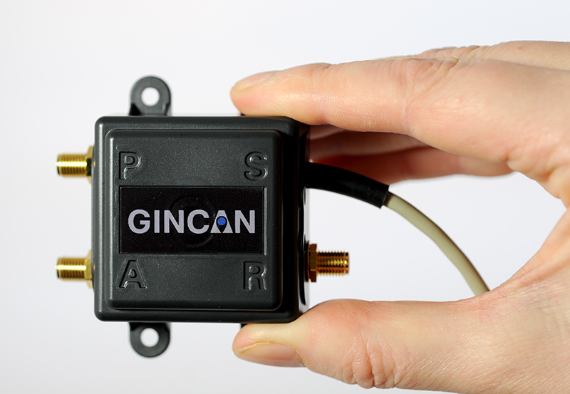
Chemring Technology Solutions has developed miniaturized GPS anti-jamming technology it has dubbed GINCAN. GINCAN is designed to combat illegal GPS jammers and is based on the adaptive antenna concept used by military systems. GINCAN has a chip footprint of six millimeters squared.
GINCAN’s reduced size and weight will significantly cut power usage and cost, the company said, making it ideal for combatting the widespread problem of low-powered GPS jamming. GINCAN can be integrated into a range of applications, including in-vehicle satellite navigation systems and cellular technology, and can be used for the protection of the critical infrastructures which rely on GPS to provide positioning and timing.
GPS jammers have already been developed to interfere with the European Union’s Galileo system, which will provide European satellite navigation independently from the Russian, USA and Chinese systems by 2019. Chemring Technology Solutions, based in Romsey, England, has anticipated this problem and its GPS anti-jamming technology will also support systems using Galileo.
Once the preserve of the military, there is now an increasing demand for GPS protection in the civilian market as illegal GPS jamming equipment becomes widely available on the Internet. The £1.5 million government-funded Sentinel project, designed to measure GPS jamming on UK roads, recorded more than 60 individual jamming incidents across six months at a single location. Such attacks could seriously impact industries, including maritime, aerospace, the emergency services and even stock market trading.
“Many years of developing GPS protection technology for the military has enabled our research and development team to miniaturize anti-jamming technology,” said Martin Ward, product manager, Chemring Technology Solutions. “GINCAN can now be easily integrated in to a range of applications to provide effective protection against jamming devices.
“As we become increasingly reliant on GPS technology, and low-cost jammers are proliferating, so a potential time bomb is being created. Chemring Technology Solutions is now able to offer the answer to this problem with jammer protection at a reduced size, weight, power and cost footprint.”
GINCAN is an export controlled product and subject to UK export restrictions.
Google Maps now has Terrain View, which enables users to see terrain maps for an area.
Terrain view shows the 3D elevation of natural geographic features, such as mountains and canyons. Topographic contour lines are overlaid on the map to show elevation levels with altitude information displayed in gray numbers.
Google Maps also offers traffic, transit, and biking views.
Google Maps tweeted about the new terrain feature, showing an example:
Three weeks ago, GPS World / Geospatial Solutions held a webinar highlighting new technologies for imagery and data capture. The webinar had four presenters: Paul Smith of CycloMedia, Ted Ralston with Soft Power Solutions, Peter VanAmburgh from IIF Data, and John Ciampa CEO of Alta. You can view a YouTube video of the session. Because webinar time is limited, we couldn’t cover the technologies in detail, so I’m covering some of the technologies one column at a time.
In February, I devoted my column to CycloMedia, so you may want to review that material if you want more detail. This month I want to delve into the Alta balloon system that was presented by John Ciampa, the CEO of Alta. John was the original patent holder of Pictometry, the revolutionary high resolution geo-referenced metric oblique imagery system. He and Steve Schultz took the concept from theory to a practical functioning system that has been an industry standard for over 10 years.
John continues his research, dividing his time between the Rochester Institute of Technology (RIT) and Florida International University (FIU) while also working with the National Science Foundation (NSF). Although Pictometry was very successful, he also understood the limitations and cost of a manned aircraft as a capture system, especially for disaster response. Pictometry was a very capable system, but John felt that what was needed was a system that had a “lighter footprint” figuratively and literally. John took his knowledge and experience, and combined it with the latest developments in micro-miniaturized technology, to develop a system that was elegant in its simplicity and usefulness.
The Platform
Simply put, the Alta balloon is a steerable oblique geo-referenced camera system attached to a weather balloon. By using a balloon, John solved several problems associated with manned aircraft — cost, image quality, and accessibility. A balloon is cheaper than an aircraft, doesn’t require a licensed pilot, is more easily deployable, and can “fly” at lower altitudes.
Even a small aircraft is expensive, and requires a trained pilot and complex support logistics. A small used aircraft can run $50,000 to several hundred thousand dollars. Additionally, most high-end aerial imagery systems generally require expensive FAA-approved modifications of the airframe. This adds cost, and limits the aircraft that can be used. Equipped with Pictometry cameras and electronics, a total aircraft capture system can easily cost $300,000 and up.
A significant factor during disaster response events is transportability and support. Past experience has shown that it can be very difficult to transport and operate even small aircraft in disaster regions, especially if the damage is widespread. Fuel and ground support in disaster sites can also be a serious limitation. By comparison, a balloon system can be carried in a suitcase, shipped quickly, and set up in less than an hour. Since the cost is in the range of several thousand dollars, multiple systems are practical and can be deployed in numerous remote locations. Equally impressive is that operators can be trained in less than an hour.
But don’t get the impression that Alta is as simple as strapping a digital camera to a balloon. Achieving the image quality, accuracy and dynamic performance of the Alta system requires a very sophisticated package, including the balloon, controls, communications and sensors. The balloon system is actually two balloons, one within the other, an outer balloon and inner lift gas balloon. The outer balloon provides some external protection while presenting a consistent profile. The inner balloon provides the lift and is filled with either hydrogen or helium.
The altitude is remotely controlled by venting lift gas to descend or by dumping water ballast to ascend. An onboard computer and sensors can also maintain altitude autonomously. When the balloon is brought down, a tethered weight drops to several feet under the balloon. The weight contacts the ground first and “anchors” the balloon and payload for retrieval. This keeps the balloon and payload off the ground, and also makes it easier to spot.
There are several modes of operation that are determined by the operator prior to launch:
“Path Mode”: The balloon is released, ascending to the programmed altitude, then drifting with the wind currents before descending back to the ground.
“Patch Mode – single tether”: Used to launch and retrieve the balloon. The balloon ascends to altitude, and its position is downwind based on the strength of the wind acting on both the balloon and tether.
Patch mode with single tether.
“Patch Mode – multiple tethers”: Very precisely controls the location of the balloon over a limited area. This is very similar to the overhead cameras used in televised football games but in reverse, since the balloon wants to fly up.
Patch mode with multiple tethers.
The system can also be equipped with a parachute for emergency landings, a solar trickle charger for extended missions, and even a quadcopter that can steer the balloon to specific target areas. The lift capability of the balloon permits significantly longer duration flights than a quadcopter alone. A detailed operator’s manual is available for review at the Alta website — look for the Operators Manual.
The Payload
The modular payload is complex, but also lightweight and compact thanks to the latest developments in miniaturization. It consists of a precision GPS unit, inertial measurement/navigation unit (IMU), an onboard computer, environmental sensors, Wi-Fi communications, and an aimable high-resolution camera on a stabilized gimbal. The camera can be RGB, night vision or even multi-spectral. The imagery is downloaded as captured and delivered almost real-time.
Modular payload.
The Output
Because the balloon floats at low altitudes, image resolution is an impressive “game changer.” Here is just one example comparing a 4-inch pixel Pictometry/Bing image taken from 3,000 feet to a 1-centimeter pixel Alta image of the same location taken from several hundred feet.
Bing (left) and Alta images of stadium seats, compared.
Similar to Pictometry, the system uses GPS and IMUs to very accurately determine the camera location and attitude. That information, linked via algorithms to the captured imagery, results in imagery that is geo-referenced, measurable and available with full metadata, including the time of capture. I can’t over emphasize how important this is. Having instant access to imagery is nice, but having that imagery already geo-referenced means that the imagery can be quickly and easily imported into a GIS and overlaid with legacy GIS data for instant analytics.
The system has been used for many mundane applications such a real estate, agriculture, construction/engineering and event planning. More critical applications include crime-scene monitoring, surveillance and disaster response. Recently, in response to a South Florida Mall shooting, police launched an Alta balloon to view the crime-scene location. The imagery was instantly and continuously sent to police station computers and mobile devices of responders en route to the mall for pre-planning of their response. Viewing rooftops and walkways for victims and perpetrators, a near real-time operational picture was provided to police before putting themselves and others in harm’s way.
Actual image from an Alta balloon used in SWAT team maneuvers.
Dolphin Mall Sweetwater Florida, May 14, 2014, 6:05 a.m.
The Potential
I’m especially excited about the potential lifesaving use of Alta balloons. On numerous occasions I was involved in emergency response actions, and the dominant overarching need was high-quality imagery that could be combined with legacy data and imagery as close to real-time as possible. This system answers that need, and at a low cost. I could envision several Alta systems in every county nationwide ready to deploy on a moment’s notice. I believe that these units would be especially valuable for disaster response in second- and third-world countries. Dozens of Alta systems and trained operators could be delivered on short notice to major disaster sites, providing almost real-time common operational pictures for first responders. The added advantage is the very light need for logistics and support.
Military applications could be equally important. The silence of balloons coupled with a small visibility profile, including almost total invisibility at night, makes them ideal for reconnaissance and surveillance. The relatively low cost of the platforms also permits them to be expendable. In a tethered mode, the persistent “eye in the sky” could serve as a deterrent, or at a minimum make hostile activity more complicated for the perpetrators as they try to hide activities from the balloon. The “light” logistics and fast operator learning curve are just added benefits.
A key question raised during the webinar was FAA control. John indicated that the FAA does not consider the Alta balloons in a tethered mode subject to their control, and is currently reviewing it in a drift mode. John further amplified that the very low altitude of operation and dual control of descent should also exempt the drifter from FAA involvement. Alta could provide a significant advantage where UAS operations are restricted or not practical.
In a recent book, “Smaller Faster Lighter Denser Cheaper” by Robert Bryce, reviewed in the Wall Street Journal, the author argues that a similar dynamic, making less do more, drives virtually every technological change that has created the modern world, from cars and airplanes to advanced medicine, strategic metals and the iCloud. Alta balloons are certainly a good example.
I was an early proponent of Pictometry because, unlike abstract GIS data and ortho imagery, the metric oblique imagery was easily understood by non-GIS users. I saw many examples where it saved lives because police and firefighters were able to form and exploit a common operational picture quickly. Alta has me equally excited because it brings that same capability to users with a much simpler system that delivers almost real-time imagery at a cost anyone can afford. This technology is going to help a lot of people.
“What can we do to reduce the vulnerability [of GPS] and ensure that the expectations of the public are going to be met?” asked Dr. Bradford Parkinson as he opened his presentation this morning (Tuesday, April 15) at the European Navigation Conference, ENC-GNSS 2014 in Rotterdam, The Netherlands.
Parkinson went through his 61-slide, 50-minute briefing on what he called “PTA” — Protect, Toughen, and Augment — a proposal concerning not only GPS but PNT systems globally. An article by Parkinson based on this talk will highlight the special 25th Anniversary edition of GPS World, to appear in conjunction with this year’s July issue.
Brad Parkinson
After briefly overviewing the many worldwide applications of GPS and its penetration and participation in several vital markets, Parkinson stated “If we want to ensure the economic benefits of GPS, there are some essential needs that a user has. The first need is availability, and I’m defining availability in a certain way. It’s at the required accuracy for the application involved, and it has a bound on the random events that happen out there.
“The second required aspect is integrity, as in ‘I know I’m getting this accuracy, the system is not lying to me.’ In many cases, it’s required that the system not lie to you more often than once in 10 to the seventh (10 million) times.”
Parkinson developed his Protect, Toughen, and Augment proposal in part in response to a remark he heard from a high U.S. government official who opined that “GPS is much too vulnerable, we need to replace it.” While agreeing that the system is vulnerable, Parkinson has strived for a more constructive approach to the problem.
At the end of his presentation, Parkinson introduced one of his colleagues in the audience, from his early days on the GPS Program, and stated that if it was not for Hugo Fruehauf’s expertise with atomic reference systems in 1973, there might never have been a GPS program.
Parkinson was among attendees at an ENC event at City Hall hosted by the Mayor of Rotterdam, The Netherlands. From left are Hugo Fruehauf, Mrs. Bradford “Ginny” Parkinson, Professor Bradford Parkinson, Don Jewell — GPS World Defense Editor, Jac Spaans — Chairman of the Organizing Commitee of the ENC, and Adrianna Spaans.
Chartered Land Surveyors from the Upper Savoy region in France set up a Leica Nova MS50 MultiStation to take a 3D scan of the Mont Blanc ice cap and also a Leica Viva GS14 GNSS antenna to measure the mountain’s elevation.
Reaching the top of Mont Blanc, Europe’s highest peak, is a formidable challenge even to the most experienced alpinists — not only because of its elevation, but also because of its weather conditions. Strong winds and snowfall at the summit constantly cause altitude changes to the summit’s ice and snow cap. Such changes motivate expert surveyors to try out the latest in measurement technology, like the Chartered Land Surveyors located in the Upper Savoy region in France as well as two surveyors from Leica Geosystems France. For their seventh expedition, they decided to make the first ever 3D laser scan of the shape and volume of this legendary glacier using the Leica Nova MS50 MultiStation.
Toward the end of 2013, surveyors braved temperatures of -10⁰ C and winds of over 50 km/h,and set up a Leica Viva GS14 GNSS antenna to measure the height and also take roughly 100 point measurements of the ice cap. The Leica MS50 MultiStation scanned the ice cap at an altitude of over 4,800 meters under extreme conditions and recorded thousands of points in a matter of minutes.
The 2013 expedition proved that the current elevation of Mont Blanc is 4,810.02 meters, which is 42 centimeters less than in 2011. The actual rock summit has an altitude of 4792 meters; however, the snow covering the peak may vary the actual summit’s altitude anywhere from 15 to 20 meters. Expedition partner Géomédia calculated the volume of the ice cap covering the rocky summit at 20,213 m³ and produced a 3D animation from the scan data as well. In the future, these results will help researchers determine possible changes to the ice cap caused by global warming.
“Using the Leica Nova MS50 MultiStation to make a 3D model of the biannual Mont Blanc summit expedition was a challenging exercise that resulted in highly accurate data,” said Philippe Borrel, owner of the surveying company Cabinet Borrel and an experienced member of the expedition team. “Collecting data under such extreme conditions quickly and efficiently is extremely important. This time, we were able to reduce time expenditure needed to complete the task. The MultiStation was surprisingly easy to carry in a backpack, considering the rocky terrain, steep slopes and windy ridges we had to climb.”
The U.S. National Space-Based Positioning, Navigation, and Timing (PNT) Advisory Board has published the minutes of its December 4–5, 2013, meeting, opening with a quote from Albert Einstein, “We cannot solve our problems with the same thinking we used when we created them,” courtesy of Board Chair Dr. James Schlesinger. Among many other topics addressed, the Board heard a report from Major General Martin Whelan, Director of Requirements, Air Force Space Command, on the road ahead for implementation of the GPS Civil Navigation (CNAV) message on L2C and L5. The subject has stirred some controversy of late, particularly between the U.S. Departments of Transportation (DoT) and Defense (DoD), and DoT is currently seeking public comments on the plan.
The meeting minutes relay the gist of General Whelan’s CNAV remarks as follows:
“While sequestration is having various impacts on DoD budgets, thus far GPS quality, service and refresher plans are unaffected. The FY15 budget is under development.
“CNAV has been under discussion for a considerable time. Currently, L2C and L5 signals are being transmitted, but without a navigation message. AFSPC is working hard to activate these messages as soon as possible. One of the reasons for the delay is that additional time was needed to complete testing prior to activation. Testing began in late summer 2013 and, based on initial test results, a “way ahead” has been plotted. Gen William Shelton, AFSPC commander, wished to assure the Advisory Board of his unwavering commitment to providing full-time broadcast CNAV messaging capability on L2C and L5 as soon as possible.
“The CNAV capability will add diversity and robustness for dual frequency users. Gen Shelton intends to provide details plans to the NCO and a report to the next EXCOM meeting. Current plans are to begin initial broadcasting in the spring of 2014. CNAV uploads will occur twice weekly. The signal will meet GPS Standard Positioning System (SPS) standards, but may not achieve current accuracy levels until full implementation in late 2014.
“CNAV live sky testing occurred in June and was conducted in cooperation with civil, industry, and international partners. The two-week test series included independent assessment and verification. The tests identified four errors that required action. The first, which was addressed in real time, related to implementation of the test series. The second required improvement to the tools suite, which should be totally integrated into the ground segment by December 2014. The third and fourth errors required patches to satellite software. All four issues are now regarded as closed.”
The meeting minutes report this further discussion of CNAV.
“Dr. Schlesinger raised the topic of sequestration and how, based on his early career in budgeting, no budget item is sacrosanct. GPS has enjoyed protection from Deputy Secretary of Defense Ashton Carter, but he is now stepping down and his replacement not yet known. This could provide an opportunity for “the men with the green eyeshades” to come forward to eliminate things.
“Gen Whelan said he agreed that with sequestration, everything – including GPS – is on the table. However, AFSPC continues to strive to avoid any degradation in service. He also welcomed the continued support of the Advisory Board.
“Dr. Schlesinger quoted from a 2006 document: “Our position is to continue to provide the best space-based positioning, navigation and timing service in the world.” The Chinese are now “moving up” on GPS. How is GPS going to stay ahead?
“Gen Whelan said AFSPC is aware of China’s steps in capacity and signal diversity. This, however, does not alter his confidence that GPS remains the “Gold Standard” of world GNSS systems. AFSPC is committed to maintain GPS leadership. However, because of sequestration and budget cuts, this position could not be the position of some people outside of the Air Force.”
A subsequent presentation from the Department of Transportation given by Karen Van Dyke, Director for PNT, DOT Research & Innovative Technology Administration (RITA), did not directly mention CNAV, according to the meeting minutes, but did include this update on civil signal monitoring, taken from the meeting minutes.
“DOT is responsible for performance monitoring of GPS civil signals. She called attention to the International Committee on GNSS’s (ICG’s) transparency principle that “Every GNSS provider should publish documentation that describes the signal and system information, the policies of provision, and the minimum levels of performance offered for its open service.” Currently, this is only done on GPS L1 C/A signals. Performance standards for L2C and L5 have not yet been established. The crucial function of signal/service monitoring is to verify that commitments to GNSS performance are being met. Additionally, monitoring improves the situational awareness for GNSS operators, and provides assurance that any civil service failure is detected and resolved promptly. All these factors support the GPS performance history that has made it the world’s Gold Standard.
“The DOT “GPS Civil Monitoring Performance Specifications” (CMPS) document defines the measurements required to show if performance standards for monitoring GPS’ signals/service are met. The document’s first version was developed in 2005 and listed 193 requirements, covering performance monitoring, signal monitoring, non-broadcast data requirements, and reporting and archiving requirements. The document was later updated to align with the 2008 GPS SPS Performance Standard. The most current CMPS was completed in April 2009 and is available at GPS.gov. Since 1999, DOT has published quarterly reports providing analysis of SPS performance for the Federal Aviation Administration (FAA).”
Further Topics
Other reports delivered to the Advisory Board, and available in the the full meeting minutes, available here, include the following. In addition, many PDFs of the individual reports are available through the meetings Agenda page.
Global Differential GPS System as a Civil Monitoring Utility
Dr. Yoaz Bar-Sever, Manager, Global Differential GPS System, NASA Net Propulsion Laboratory
Automated Driving & Safety Considerations (collision avoidance warning, vehicle-to-vehicle communications, and driverless automobiles)
Russell Shields, PNT Board Member, founder of Ygomi LLC
GPS Disruptions: Efforts to Assess Risks to Critical Infrastructure
The Government Accountability Office’s (GAO) Report on Enhancing Interagency Actions
Eli Albagli, senior analyst, GAO
2013 National Infrastructure Protection Plan (NIPP)
Department of Homeland Security Implementation
Robert Kolasky, Director Strategy and Policy, DHS Office of Infrastructure Protection
Economic Impacts of GPS on Key Sectors in the U. S. Economy
Dr. Nam D. Pham, economist/managing partner, NDP Consulting Group
GNSS Signal Capability – Multi-Constellation Management
Cross-Correlation of Existing & Evolving C/A System Signals
Dr. A. J. Van Dierendonck, AJ Systems
How Far to Take GNSS Interoperability/Interchangeability?
Ken Hodgkins, Office of Space & Advanced Technology, Department of State.
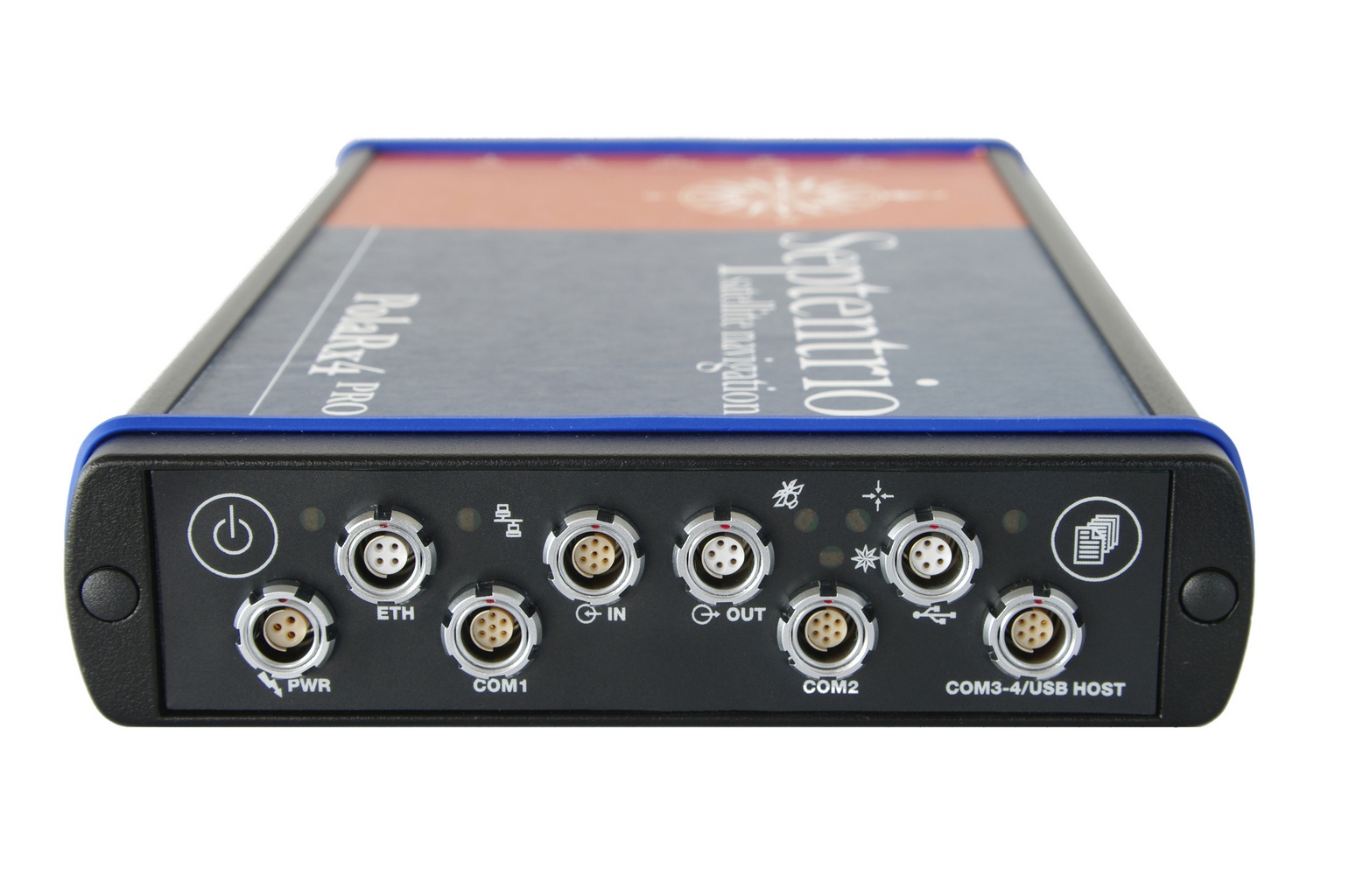
Veripos, a global provider of precise satellite positioning solutions to the international offshore and marine industries, is concluding the upgrade of its global network of GNSS reference stations with high-performance multi‑frequency GPS/GLONASS/Galileo/BeiDou receivers from Septentrio.
Veripos owns and operates a network of more than 80 reference stations worldwide that is used to determine estimates of the orbit and clock errors of multiple GNSS satellite constellations. Veripos uses these estimates to calculate corrections which are then broadcast to end users to significantly improve the accuracy of positioning. At the heart of the network is Septentrio PolaRx4, a full-featured reference receiver that provides high-quality tracking and measurement of all available and upcoming GNSS signals.
The upgrade of the Veripos global network of reference stations with the latest Septentrio reference receiver technology is an outcome of the multi-year collaboration between the two companies. Septentrio also supplies Veripos with multi-frequency GNSS and heading receivers for its marine business, including the LD series of integrated mobile units that deliver the complete range of Veripos augmentation services to its customers worldwide.
“Septentrio reference stations are renowned for their excellent data-quality and robustness,” commented Bobby Johnson, Chief Technical Officer of Veripos. “Septentrio technology enables us to provide a full range of services and to remotely manage and upgrade the hardware to enhanced features, which is crucial for managing a worldwide reference network, where the equipment is often not easily accessible.”
“We are delighted to see continued positive outcome from the technical and commercial relationship we have established with Veripos over the years and that has developed into Septentrio enabling Veripos to deliver a variety of solutions with high-quality and robust industrial performance everywhere on the globe to the benefit of a multitude of users in one of the most demanding industries,” said Jan Van Hees, head of sales and business development at Septentrio.
March 7, 2014 Update: WASHINGTON, D.C.–The Federal Aviation Administration today issued a notice appealing a decision by an NTSB Administrative Law Judge in the civil penalty case, Huerta v. Pirker. “The FAA is appealing the decision of an NTSB Administrative Law Judge to the full National Transportation Safety Board, which has the effect of staying the decision until the Board rules. The agency is concerned that this decision could impact the safe operation of the national airspace system and the safety of people and property on the ground.”
————————————
On March 6, 2014, Federal Judge Patrick Geraghty dismissed a case the Federal Aviation Administration (FAA) brought against Raphael Pirker, accusing Pirker of illegally using a drone to make a video of the University of Virginia. The FAA attempted to levy a fine of $10,000 against Pirker, described in an article published in Geospatial Solutions in December 2013.
Brendan Schulman, Pirker’s attorney, told Geospatial Solutions, “The FAA’s position on this is based on a policy statement, not an enforceable regulation.”
1. Neither the Part 1, Section 1.1, or the 49 U.S.C. Section 40102(a)(6) definitions of “aircraft” are applicable to, or include a model aircraft within their respective definition.
2. Model aircraft operation by Respondent was subject only to the FAA’s requested voluntary compliance with the Safety Guidelines stated in AC 91-57.
3. As Policy Notices 05-01 and 08-01 were issued and intended for internal guidance for FAA personnel, they are not a jurisdictional basis for asserting Part 91 FAR enforcement authority on model aircraft operations.
4. Policy Notice 07-01 does not establish a jurisdictional basis for asserting Part 91, Section 91.13(a) enforcement to Respondent’s model aircraft operation, as the Notice is either (a) as it states, a Policy Notice/Statement and hence non-binding, or (b) an invalid attempt of legislative rulemaking, which fails for non-compliance with the requirement of 5 U.S.C. Section 533, Rulemaking.
5. Specifically, that at the time of Respondent’s model aircraft operation, as alleged herein, there was no enforceable FAA rule or FAR Regulation applicable to model aircraft or for classifying model aircraft as an UAS.
Upon the findings and conclusions reached, I hold that Respondent’s Motion to Dismiss must be AFFIRMED.
IT IS ORDERED THAT:
1. Respondent’s Motion to Dismiss be, and hereby is: GRANTED
2. Complainant’s Order of Assessment be, and hereby is: VACATED AND SET ASIDE
3. This proceeding be, and is: TERMINATED WITH PREJUDICE.
ENTERED this 6th day of March, 2014, at Denver, Colorado.
CompassTools Inc., a distributor of mapping and GIS products for field data collection, has installed a GPS reference station in Durango, Colorado, to provide freely available differential correction data to GPS users in the Four Corners area of Colorado, New Mexico, Utah and Arizona. The correction data can significantly enhance the accuracy of location coordinates captured by GPS receivers used in mapping and surveying applications.
“We have many clients involved in GIS mapping projects for energy development, utility asset location and local government applications in the Four Corners region,” said CompassTools CEO Steve Chiles. “CompassTools set up the Durango reference station to help them complete their mapping projects with greater efficiency and accuracy and at less expense.”
CompassTools is a value-added reseller of hardware and software mapping solutions from Trimble, Laser Technology, Ricoh, GeoSpatial Experts, Esri, and CartoPac. Since 1994, CompassTools has sold, leased, repaired, and offered training on the latest GPS and GIS mapping products in an eight-state region that includes Colorado, Wyoming, New Mexico, Minnesota, Nebraska, the Dakotas and parts of Texas. In addition, the firm provides expert GPS/GIS consulting and creates customized bundled packages to meet the specific needs of complex data collection projects.
The Trimble NetR9 GNSS reference station installed by CompassTools in Durango is capable of receiving location signals from GPS, GLONASS, and Galileo. CompassTools established the unit as a Continuously Operating Reference Station (CORS) accepted by the National Geodetic Survey (NGS) and part of Mesa County Colorado’s Real Time Virtual Reference Network.
“The Trimble NetR9 broadcasts differential correction data in real time via a cellular signal,” said Chiles. “And the correction data is also posted automatically to the CompassTools website for post-processing.”
Chiles explained that this means the GPS user has the option — usually depending on the capabilities of their portable GPS receiver — to correct their location data and improve its accuracy in real time as they collect it in the field. Or the GPS user can download the correction data from the CompassTools website when they return to the office and process the data after the fact. An advantage of real-time correction is the user knows the accuracy of the GPS data being collected while still in the field.
“The ultimate accuracy of the collected location data depends on the quality of GPS receiver being used,” said Chiles. “We have many clients in Durango using mapping-grade handheld GPS data collection devices achieving accuracy better than 10 centimeters using the reference station data.”
 Topcon Positioning Group has added a cellular modem option for the HiPer SR for GIS receiver.