Topography of Mount Cook, New Zealand’s tallest peak, changed following a rock avalanche. (Photo Wikipedia Commons, C.M. Lynch)
The National School of Surveying, University of Otago, implemented Hexagon Geospatial technologies provided by Intergraph in its quest to measure the summit of Mount Cook, the tallest mountain in New Zealand and a UNESCO World Heritage Site. The University of Otago is New Zealand’s oldest university.
The university turned to Hexagon Geospatial’s ERDAS IMAGINE and IMAGINE Photogrammetry (formerly LPS) to help measure the height of Mount Cook, also called Aoraki, following a large rock avalanche that changed the peak’s topography and height in 1991. For many years, the university has benefited from Hexagon Geospatial’s education licenses through Intergraph, and chose these technologies for the project because of their image processing and photogrammetric capabilities, as well as integrated workflows.
“ERDAS IMAGINE is the cornerstone of the project. It started from there,” said Pascal Sirguey, senior lecturer at National School of Surveying and project leader. “Using the photogrammetric capability, we were led to look more closely at what the model was telling us. The software gave us the right answer in the end.”
Following the avalanche, a resurvey found the mountain to be 3,754 meters high — down from the surveying estimate of 3,764 meters in 1881. The university undertook the unique challenge of validating the new elevation. Photogrammetry and remote sensing were the only viable methods for measuring the summit as it is considered sacred by the Maori tribe of Ngāi Tahu and standing on it is prohibited.
Using Hexagon Geospatial’s software, along with Global Navigation Satellite System receivers, the university determined the actual height of Mount Cook is 3,724 meters. For the university’s remarkable efforts, Sirguey received the top award from the New Zealand Institute of Surveyors in 2014 for teaching and education and the New Zealand Spatial Excellence Award 2014 in the Education and Professional Development category.
The University of Otago was founded in 1869 by an ordinance of the Otago Provincial Council. Its School of Surveying offers the only academic qualification leading to professional recognition as a professional land surveyor in New Zealand, following a period of post-graduation training and examination by the New Zealand Institute of Surveyors. The courses offer a broad range of disciplines — surveying, land planning and development, survey measurement and Geographic Information Systems — that equip graduates for a professional career.
Provided through Intergraph, Hexagon Geospatial’s education program provides the university with a complete geospatial software portfolio that offers support and tools for academic research projects and teaching.
UBL Interactive, Inc. today announced a global data syndication agreement with Amsterdam-based NavAds to help businesses ensure their profiles appear in navigation services and devices.
The NavAds agreement will improve the quality of the business listing information and the breadth of distribution for UBL customers. NavAds specializes in business listing insertion and advertising on navigation services such as TomTom, Garmin, Nokia HERE, Waze, Yandex, and others.
UBL CEO, Doyal Bryant, said the partnership was significant not only because it addressed the growing use of mapping tools, but because it was a global arrangement. “UBL is focused on an increasingly mobile world, and services which are not confined by national borders. Navigation services are constantly changing and evolving and with our NavAds partnership, our customers can be assured anywhere globally, they will get the benefit of the most advanced distribution in the mapping space,” he said. “It extends our place as the global leader in business listing syndication, with more publishers and international local partnerships than any others in the space.”
NavAds CEO, Lex ten Veen, said UBL would bring many new owner-verified business locations to the NavAds platform and network. “Businesses need to be found on these navigation devices, and NavAds can give UBL’s customers great confidence their visibility is fully optimized,” he said.
The services will be integrated into UBL product sets immediately.
Trimble has introduced TerraFlex Advanced, an enhanced edition of its TerraFlex field data capture software, which manages asset collection and update activities for everyday geospatial requirements. Organizations across a variety of industries, including environmental management, utilities and government agencies, can deploy a common workflow for field workers to collect or inspect their assets efficiently using TerraFlex Advanced.
TerraFlex Advanced enables GIS professionals to stay productive by keeping their data and devices up-to-date and organized. It allows users to import existing assets or GIS data into their TerraFlex projects and make real-time updates to the data in the field. The information can be shared across the project organization, so all project members — from the field to office — are working with the most up-to-date data available.
In addition, a new version of the TerraFlex Mobile apps supports Trimble RTX technology-based correction services. Trimble RTX (Real Time eXtended) is a high-accuracy GNSS correction technology that delivers repeatable centimeter-level positioning worldwide to compatible GNSS receivers. GIS professionals now have more flexibility to achieve the accuracy required by their highly mobile workflows in real-time, without being tied to a base station or local VRS network.
With TerraFlex Advanced, users can collect, process and manage geospatial data quickly and efficiently across a fleet of mixed consumer and professional data collection mobile devices and platforms. Local governments who require regular data updates on city assets, utility workers performing frequent inspections on infrastructure, and many other mapping and GIS organizations can update new and existing data while in the field much faster.
“In today’s environment, asset conditions are constantly changing and access to real-time information about these assets is crucial to decision-making and sustainability of those assets,” said Alain Samaha, business area director of GIS and Software for Trimble’s Geospatial Division. “TerraFlex Advanced addresses this growing requirement by ensuring GIS field crews are equipped with current information so they can make informed decisions, avoid costly rework, and plan and schedule resources efficiently for the maintenance of assets.”
Part of the Trimble InSpherecloud-based software platform for the management of geospatial applications, data, and services, TerraFlex Advanced extends the robust project, user and form functionality in the original TerraFlex Basic edition, keeping field crews organized and productive on a variety of devices and in a wide range of environments.
In addition to TerraFlex Advanced software, Trimble also announced new enhancement to its InSphere platform applications — Equipment Manager and Data Manager.
Equipment Manager — A software application that enables geospatial enterprises to unify management of all their equipment, Equipment Manager now lets users manage custom equipment types, including non-Trimble devices, accessories, and any other equipment that needs to be managed together with their Trimble mapping and surveying equipment. Additionally, users can stay on top of required updates and keep their field equipment properly maintained with service scheduling and alerts.
Data Manager — Data Manager allows users to securely access, search, visualize and share geospatial information. This module now expands support for more data types, including all features from TBC files, image features, and TGO files, enabling users to upload more data into the application to manage, view, search and share with other project stakeholders.
CMTINC.COM has released the Wetland – Stakeout application for use on the Apple iPad. Besides providing Feature digitization and GPS Stakeout functions, this app will let the users create a custom data entry and report form. The form could be a simple inventory log, price quote, or job contract, or a sophisticated form for collecting GIS data.
In particular, a customizable report form is built into the app to facilitate the data collection for wetland delineation. This wetland determination data form contains built-in logic as well as formulas for performing automatic computations. It is based on the “Wetland Determination Data Form — Arid West Region” provided by the U.S. Army Corps of Engineers. The data collection form can be modified by the users for use in other regions.
The Wetland – Stakeout app will let the users digitize the test sites in a map job or import the test sites from Shapefiles or DXF files. The users can then use the stakeout function to help them get to the test sites and record the observation data. Now that the iOS devices are able to work with some external sub-meter GPS receivers, a user could also record fairly accurate location data for the test holes that are actually dug on site. After completing the wetland data entry, the users can send the report to a PDF file and email it back to the office.
The Wetland – Stakeout app is one of a series of GPS-based iOS apps developed by CMTINC.COM. It is now available for download from the iTunes App Store.
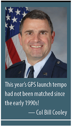
By Colonel William T. “Bill” Cooley, U.S. Air Force, Director, Global Positioning System
Last year in my “Directions” article, I emphasized the commitment made by the U.S. government to ensure GPS signals are available to all users, and I shared some of our excitement in the GPS Directorate regarding the modernized capabilities we are developing and fielding. This year I’d like to share with you progress we’ve made in the past 12 months, provide an update on the modernization initiatives, and challenge civil users and receiver companies to innovate and accelerate these modernized capabilities for users worldwide.
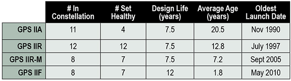
This past year has been productive for the GPS program. The most visible progress was the addition of four new Boeing-built GPS IIF satellites to the GPS constellation, bringing the total number of available satellites from 36 to 39 (SVN-33 was safely disposed in October 2014, or the number would be 40). These additions also reduced the average age of the satellites on orbit from 11.1 to 10.3 years. This year’s GPS launch tempo had not been matched since the early 1990s! Table 1 lists the current satellites in the constellation by block.
TABLE 1. GPS constellation as of October 31, 2014.
Perhaps the most exciting aspect of the GPS satellite constellation is the ever-improving performance. As I mentioned last year, the 2008 Standard Positioning Service (SPS) Performance Standard, issued by the Office of the Secretary of Defense, codifies our commitment to civil users. Among other attributes that make GPS the “gold standard” for positioning, navigation, and timing (PNT), the SPS requires a signal-in-space (SIS) user range error (URE) of 4.0 meters or less for every healthy satellite. The SIS URE is the difference between a GPS satellite’s navigation message (for example, ephemeris data and satellite clock correction data) versus the truth (for example, satellite transmit antenna location and satellite clock offset from GPS time). While the commitment of the U.S. government is four meters or less, the actual average performance over the past year has been 0.68 meters and in the past quarter has been an impressive 0.63 meters!
While this is admirable, continued modernization efforts will allow us even better performance. A significant contributor to the errors experienced by GPS receivers are ionospheric delays that can be eliminated only with knowing the characteristics of the ionosphere (free electron density in the region roughly 100-1,000 kilometers above the Earth’s surface) or by using two signals at different known frequencies. While systems like Federal Aviation Administration Wide Area Augmentation System (WAAS) and the U.S. Coast Guard National Differential GPS (NDGPS) provide a modeled approximation of the ionosphere, the new L2C and L5 civil signals on the GPS IIR-M, GPS IIF, and soon-to-launch GPS III satellites enable GPS receivers to directly measure and eliminate the ionospheric delays altogether — thereby delivering on the GPS modernization program first announced in 1999. These new signals began pre-operational Civil Navigation (CNAV) message broadcast on 28 April 2014 (with the L2C signal set “healthy” and L5 set “unhealthy” until sufficient monitoring capability is established).
With CNAV now on the air, civil users should take advantage of it. My challenge to commercial receiver companies and innovators is to incorporate the modernized signals in future receivers and continue to improve user experience and GPS performance. Currently 14 L2C-broadcasting satellites are in the constellation, and by early 2016 we expect to have 19 on-orbit and transmitting L2C (7 GPS IIR-Ms and 12 GPS IIFs). GPS modernization is well on its way from a signal-in-space perspective; receiver manufacturers and innovators must bring new, improved products and solutions to users.
Less visible but real progress modernizing the GPS Enterprise is underway with the next generation of GPS satellites, ground control, and user equipment segments. The first GPS III satellite and the newly developed navigation payload have been delayed approximately two years from the original planned delivery of the completed GPS III satellite of October 2014. But in September of this year, the GPS III navigation payload was shipped from Exelis (the payload subcontractor) in Clifton, New Jersey, to Lockheed Martin’s (GPS III prime contractor) facility in Waterton, Colorado. There, it completed the payload-level thermal vacuum testing at the end of October, a key step toward payload and eventually satellite vehicle delivery. The first GPS III satellite is now 87% complete and the program is making solid progress.
The GPS Next-Generation Operational Control System (OCX), with Raytheon as the prime contractor, experienced significant challenges in development but can also claim measurable progress this year. Complex cyber-security requirements and their implementation drove a significant number of these challenges, but are essential to provide civil and military GPS users with a secure and resilient command and control system. These and other challenges resulted in significant cost and schedule overruns and a two-year delay to the program, which drove an update to the development plan. The revised OCX plan reflects the complexity of implementing these unique cyber requirements and accounts for planned improvements to Raytheon’s systems engineering and software development approach. The plan establishes a schedule meeting GPS III’s projected first-launch date.
Despite its challenges, OCX development completed four end-to-end space-to-ground launch readiness exercises with GPS III, as well as entered the formal integration and test phase. The new monitoring station receivers are entering qualification test, and the first production receiver is on track to be delivered in spring of 2015. OCX is on track to provide robust PNT services, improvements in URE accuracy, enable access to new military and civil signals, and provide cyber security for the GPS ground control.
Our development of Military GPS User Equipment (MGUE) is another area where we have made important strides this past year. We started the year by developing a commercial market-based acquisition approach that will accelerate delivery of MGUE systems by years. In this effort, we want to establish a race to a certified marketplace where the U.S. government serves as the race official while our industry partners set their own pace to deliver capability. Our goal is to increase speed of delivery to the warfighter while capitalizing on industry’s ability to innovate.
Our MGUE team of government and industry partners (Rockwell Collins, Raytheon, and L3) successfully completed major system design reviews demonstrating a readiness to define the process of security and compatibility certification. Additionally, the team participated in the GYPSY Juliett multi-service, multi-nation PNT demonstration hosted by the U.S. Strategic Command this past summer. While we battled the elements through two hurricanes, the team successfully demonstrated the capability of M-Code receiver cards in an operational demonstration. Our goal is to enable full operational testing with four lead platforms in summer 2016.
While many risks and challenges to GPS modernization still lie ahead of us, the persistent effort by the GPS team has produced important progress in 2014 across the space, ground, and user equipment segments.
A civilian GPS user recently thanked me for providing the incredibly useful utility free to everyone around the globe. Although my impulsive response was to say simply, “You’re welcome,” I’d like to provide a more thoughtful and thorough reply that recognizes those responsible for GPS.
There are two key groups to thank for GPS: the first is the men and women across the United States government and industry who develop, field, and operate the GPS Enterprise. Among this group are satellite factory technicians, software engineers improving the ground segment, receiver designers, program office engineers, and satellite operators continuously monitoring the constellation, updating each GPS satellite’s clock correction and ephemeris data 24/7. This team works with an unwavering passion for this mission that inspires me every day.
The second group responsible for GPS is the American taxpayer who, through Congress, funds the GPS Enterprise every year.The U.S. financial commitment to GPS is not just for U.S. security or the well documented positive impact GPS has on the American economy, but for the benefit of the entire world as a global utility. GPS is the gold standard for PNT because American taxpayers continuously provide fiscal support so the GPS Enterprise’s men and women can design, produce, field, and maintain the global utility that we all have come to depend on.
Thank you for supporting this enterprise, and know that the GPS team works hard to ensure those resources are spent wisely to provide continuously improving, predictable, and dependable performance from the Global Positioning System.
Colonel William T. Cooley is director, Global Positioning Systems (GPS) Directorate, Space and Missile Systems Center, Air Force Space Command, Los Angeles Air Force Base, California.
Trimble is making available the Trimble Leap, a Trimble RTX compatible GNSS Bluetooth device. When enabled with the ViewPoint RTX correction service, Leap delivers submeter accuracy directly to the Terrain Navigator Pro (TNP) Mobile app for iOS and Android devices. The TNP Mobile app allows users to collect markers, tracks and geo-stamped photos in the field, and then sync all the GNSS data into the Terrain Navigator Pro office software.
The TNP Mobile app enables users to:
Display and navigate routes created in TNP desktop.
Collect field data such as markers, tracks, photos, videos and audio clips.
Near real-time sync between phone and TNP map software via WiFi or cellular data connection.
View data on topo, aerial, and street maps downloaded to phone for offline use. Terrain Navigator Pro offers 1-meter aerial photos for the 48 contiguous United States. The seamless USGS topo graphic maps are based off 1:24K, 1:100K, 1:250K map scales. Alaska is 1:63K and 1:250K.
Access a compass and other geo-information such as lat/long, elevation, and direction on phone.
Collect data offline. The TNP mobile app uses the GPS built into the smartphones, so users can collect field data in areas without a cellular or data signal.
Trimble Leap is compact and portable, weighing 9.5 ounces. It snaps to a smartphone or tablet to use as a handheld, can be mounted on a monopole or tripod, or can be magnet mounted to a vehicle. Leap has 16 hours of battery life and uses Bluetooth communication to connect to smart devices for ease of use and flexibility. An onboard micro SD card stores the GNSS observables data for use in the field or the office.
A micro USB port can provide power to Trimble Leap for continuous fixed-mount applications, or it can be used with battery-booster products to extend field work. Trimble Leap is charged by a standard cell phone vehicle accessory charger, a USB connection to a PC, or from a USB AC adapter.
Based on Trimble RTX (Real Time eXtended) technology, ViewPoint RTX delivers better than 1 meter horizontal accuracy 95 percent of the time without the use of a traditional RTK base station or virtual reference station network. ViewPoint RTX is delivered into the TNP Mobile app via cellular data network and is available nearly anywhere in the world.
“Trimble Leap enhances the Terrain Navigator Pro solution by adding a simple way to collect submeter accurate geolocation data with standard Android or iOS devices. Adding accuracy to TNP’s robust field-to-office data collection solution provides a value-add where low-resolution collection is not sufficient. Trimble Leap with TNP Mobile is configured and operational in minutes with little training,” said Larry Fox, business area manager for Terrain Navigator Pro.
Terrain Navigator Pro integrates powerful desktop mapping software, a cloud connected mobile data collection platform (compatible with GPS-enabled iOS and Android devices) and a robust Web portal. TNP users can plan projects in the office, collect data in the field and access projects from the Web—simultaneously. Geo-referenced data such as tracks, waypoints, photographs and video can be shared, updated in near real-time and displayed on the included topographic, aerial/satellite or street base maps.
Carlson GIS360 for Android, new from Carlson Software and Carlson EMEA, is a mobile field GIS-GPS tool that uses both GIS and surveying technologies for field data collection. The app is designed to be easy to learn and easy to use, Carlson said.
“Taking advantage of the graphics processing power of Android devices, GIS360 now includes an innovative 3D viewer so the user can see data and models in 3D on site,” said David Loescher, Carlson U.K. sales director and director of GIS360 development.
In addition to allowing field crews to navigate maps and collect and report data in the field, GIS360 provides the data and fully rendered models of mines, earthworks and pipe networks that can be viewed in 3D. The software’s Siteview function uses the Android devices’ built-in GPS, compass and gyros to give the user the view of the site in front of him.
Carlson GIS360 provides a wireless connection to any map server of choice, so users are never without a map. This saves considerable time and effort as field crews can verify that all of the data collected is accurate before leaving the site, Carlson said. No costly site revisits are necessary and no office work is needed.
The software’s cloud options provide backup for users’ data, enabling it to be shared between field and office in real time. GIS360 goes beyond positioning with a range of tools for mobile workforce management, GPS data collection, tracking and asset maintenance.
On an Android tablet or smartphone, Carlson GIS360 for Android can take GIS data anywhere. The built-in GPS and compass instantly calculate what the user is looking at and then displays the data automatically.
“The GIS360 development team set out to make the collection of asset information easier and more efficient by combining the power of GIS360 with affordable Android devices,” added Loescher. “The result not only saves a lot of field time, but also makes the process far easier for everyone concerned.”
Trimble has introduced the latest version of its smart water infrastructure mapping and work management cloud software — Trimble Connect for Water version 1.9.
The latest release of the geographic information system (GIS) centric software-as-a-service (SaaS) adds real-time, high-accuracy centimeter-level horizontal and vertical GNSS accuracy for capturing 3D asset positions. The new release includes a suite of applications that allow water, wastewater and stormwater utilities to accurately locate, inventory and visualize their infrastructure assets and increase operations and maintenance efficiency.
Trimble Connect for Water cloud software leverages Trimble’s GNSS rugged mobile devices and Esri’s GIS technologies to accurately map, locate and assess the condition of critical infrastructure assets, allowing utilities to keep their field infrastructure data up-to-date and accurate.
The new release now supports Trimble’s Geo 7 Centimeter Edition rugged handheld, integrating 3D mapping into utility field workflows and enabling mobile workers to precisely locate and map the horizontal position and elevation of buried infrastructure.
Trimble Connect for Water version 1.9 can be configured and deployed quickly on a variety of Trimble and non-Trimble mobile devices, laptops, tablets and smartphones, including Apple iPads, iPhones, Android, Windows and Windows Mobile devices to automate fieldwork and eliminate paper-based maps.
Trimble Connect uses the latest Esri ArcGIS for Server, Mobile and ArcGIS Online basemap services. The software is designed to automate a variety of specific water, wastewater and stormwater industry workflows through individual pre-configured “apps” offered within the product and as part of a subscription.
The new version provides standard core apps including Map Book, Manhole Inspector, Leak Repair, Hydrant Inspector, Valve Inspector, Meter Changeout, Incident Repair, Water Mapper, Wastewater Mapper and Stormwater Mapper. In addition, an optional partner app developed for American Flow Control (AFC) hydrant and valve data collection, “AFC Mapper,” can be purchased from AFC and their distributors for use with Trimble rugged handhelds.
Trimble Connect for Water version 1.9:
Offers centimeter-level real-time GNSS accuracy to improve the quality and accuracy of the utility’s GIS data to precisely locate hard to find assets.
Allows capturing accurate vertical elevations in real-time. Combined with horizontal precision, the solution provides high-accuracy GIS data that can be used to measure pipeline slopes, perform flow analysis and generate 3D and hydraulic models.
Supports the Trimble Geo 7 Centimeter edition with an integrated laser rangefinder.
Offers pre-configured Water, Wastewater and Stormwater mapping apps, allowing utilities to quickly start mapping network infrastructure and updating their asset data.
Provides the capability to export data in a variety of formats including Esri File Geodatabase, Shapefiles and MS Excel, which allows users to update the utility’s enterprise GIS or visualize and analyze the collected data using third-party systems.
Trimble Connect for Water version 1.9 is expected to be available in December 2014 from Trimble’s Water Division and its authorized distribution partners.
Handheld Group, a manufacturer of rugged mobile computers, has launched the Nautiz X8 rugged PDA. The Nautiz X8 is a handheld computer with superior processing power, screen performance and battery life, the company said. It is built for tough field conditions primarily in GIS, land surveying, public safety, forestry and the military.
The Nautiz X8 is built to enable efficient and reliable data collection in tough environments. It has an IP67 ingress protection rating, which means it offers complete protection against dust and sand and can withstand immersion in water. It also meets stringent MIL-STD-810G military test standards for overall durability and resistance to humidity, shock, vibration, drops, salt and extreme temperatures.
The Nautiz X8 features a high-performance Texas Instruments 4470 dual-core 1.5 GHz processor. It has 1 GB of RAM, 4 GB of iNAND Flash and a 5200 mAh Li-ion battery that lasts up to 12 hours on a single charge. It comes with a choice of operating systems — Android 4.2.2 or Windows Embedded Handheld 6.5.3.
The device has a large 4.7-inch ultra-bright capacitive multi-touch screen with chemically strengthened Asahi Dragontrail glass, offering users brightness and protection in any field condition. The unit has an ergonomic design and weighs 490 grams (17.3 ounces).
The Nautiz X8 has a dedicated u-blox GPS receiver, Bluetooth 2.0 and 802.11b/g/n WLAN functionality, as well as connectivity through GSM/UMTS or CDMA phone data transmission. A built-in 8-megapixel camera with autofocus and an LED flash lets users capture visual data quickly and easily. This handheld also features an open architecture and an extension cap system that allows for additional hardware connections such as sensors, radios and other add-ons.
Orders for the new Nautiz X8 can be placed immediately. First deliveries will begin in November.
The Nautiz X8 rugged handheld will be shown first at WEFTEC in New Orleans, followed by InterGeo in Berlin.
CartoPac International Inc. has announced a major new release of the CartoPac Mobile Platform. CartoPac 5.0 extends the mobile platform with support for Windows 8 and introduces the CartoPac Workflow Manager, which provides a structured process to manage the use of geospatial data across the enterprise.
CartoPac will demonstrate the applications and technologies of Version 5.0 in the free CartoPac Mobility Webinar Series beginning on September 30.
The CartoPac Platform is a configurable suite of field and office tools designed to maximize the productivity of crews as they digitally map, inventory and inspect critical assets using GPS-enabled mobile devices. Seamlessly integrating with the Esri ArcGIS Server, CartoPac is used extensively by oil and gas companies, pipeline operators, electric utilities, state/local governments and environmental engineering firms to populate the enterprise GIS and asset-management systems with captured infrastructure information.
The new CartoPac Workflow Manager (CWM) in CartoPac 5.0 provides organizations with a structured workflow to view, edit, validate and approve asset data as it moves from the field back into the enterprise. CWM ensures that individuals responsible for data are notified as it comes into the organization so they can incorporate the data into systems related to work-order fulfillment, risk analysis, integrity modeling and other asset management processes.
CartoPac developed CWM for the management of heavily regulated assets in the field, such as gas pipelines and electric distribution infrastructure. A module within the CartoPac Server, the CWM extension creates an audit trail of all the edits and modifications made to the data sets that represent the monitoring and maintenance of real world assets in the field.
“CartoPac Workflow Manager fills the gap between data collection and enterprise asset management systems to enable organizations to maximize the value of their data,” said CartoPac CIO Scott Crouch. “CWM enables organizations to show regulators they have a structured process for tracking and responding to the conditions of their critical assets and has proven to be key component for assisting companies with their regulatory compliance and integrity management programs.”
Further expanding the capabilities of the CartoPac mobile components, version 5.0 has been optimized for the Windows 8 operating system running on standard GPS-enabled laptop computers and tablet devices. This migration means that crews can use CartoPac to collect and manage asset data in the field on the same hardware devices they will use back in the office to run their daily business applications.
“The attractive cost, integration with GPS and expanded performance of Windows 8 tablets and laptops will enable organizations to put more personnel into the field, ensuring that vital infrastructure is mapped, inventoried and properly managed,” said Crouch “Laptop/tablet-equipped maintenance personnel in the field will now be able to run CartoPac solutions on the hardware they already use for tracking repairs and closing work orders.”
To demonstrate the advantages of enterprise asset management, CartoPac has launched the CartoPac Mobility Webinar Series, which will feature applications by electric and gas utilities and highlight new mobile technologies. The first webinar, “Applying New Mobile Technologies to Electric Utility Inspections,” will be presented with EDM International Inc., a Colorado electric utility services company.
The free “Applying New Mobile Technologies to Electric Utility Inspections” webinar will be held on September 30, 2014, at 4:00 pm Eastern Time. To register, click here.
Intel has commercially launched the XMM 6255 modem to provide a wireless solution for the billions of “smart” and connected devices that are expected in the coming years. At about 300 square millimeters, Intel says it is the world’s smallest standalone 3G modem, designed for networked sensors and other Internet of Things applications such as wearables, security devices and industrial equipment.
The XMM 6255 features the SMARTI UE2p transceiver, which is based on the new Intel Power Transceiver technology, a design that combines transmit and receive functionality with a fully integrated power amplifier and power management on a single chip. This design approach reduces XMM 6255’s component requirements, resulting in a smaller modem that helps manufacturers minimize their build of material costs. It also protects the radio from overheating, voltage peaks and damage under tough usage conditions, which is important for safety monitors and other critical IoT devices.
Additionally, the XMM 6255 modem features a radio architecture that enables it to perform exceptionally well in challenging real-world situations, including:
Low signal network coverage: The XMM 6255 modem provides reliable communication when it comes to transmitting information in low signal zones like a parking garage or a home basement.
Small-sized devices: Devices with a small form factor like a smartwatch or a sensor may not have enough space for a normal-sized 3G antenna, which can affect connectivity quality and reliability. The XMM 6255 modem is specially designed for such devices and delivers great 3G connectivity even with small volume antennas not meeting conventional mobile phone quality standards.
The integration of the power amplifier and transceiver in this modem simplifies the design and minimizes device development costs, which means developers can launch more products more quickly, and in a more cost-effective manner.
The XMM 6255 is available in the u-blox SARA-U2 module and Intel expects to have additional partnerships in the coming months.
“Aeroptic is a commercially available mapping system that supports every mission in which the National Guard engages, ranging from incident assessment and disaster response in Domestic Operations (DOMOPS) to reconnaissance and situational awareness on the OCONUS battlefield,” said Kevin Gunde, executive vice president, Surveillance and Exploration Systems. “Aeroptic can be deployed on a variety of fixed- and rotor-wing platforms, including the National Guard UH-60 Blackhawk.”
KEYW developed the Aeroptic solution with image quality, positional accuracy and ease of use in mind. The system integrates a full-color electro-optical (EO) camera, GPS/IMU, and user-friendly geo-processing software based on non-proprietary open standards. The system is compact, light-weight and ruggedized for deployment in harsh environments.
The rapid-refresh EO camera captures imagery of extraordinary quality by employing advanced noise reduction, image sharpening algorithms and high-end lenses with innovative configurations, the company said. The interchangeable lenses offer multiple focal length options that enable the Aeroptic camera to acquire high-resolution visible-band imagery with sub-meter geo-positional accuracy from varying flight altitudes without surveyed ground control points.
Aeroptic offers the option of processing imagery in the air or on the ground, producing unclassified, wide-area ortho-mosaic maps in near real time. Generated imagery products are ready for immediate ingest into standard commercial viewing tools and GIS packages.
“No expertise in GIS or cartography is needed to make full use of the Aeroptic system,” said Kevin Gunde, executive vice president, Surveillance and Exploration Systems. “With just eight hours of training, the typical user can produce content-rich image maps ready for distribution within minutes after acquisition.”
KEYW will be discussing the Aeroptic Mapping System and its many mission applications in booth #512 at the NGAUS General Conference & Exhibition being held August 22-25, 2014, in Chicago’s McCormick Place.