Category: GPS

  • Update: Ninth GPS III successfully launched

    Update: Ninth GPS III successfully launched

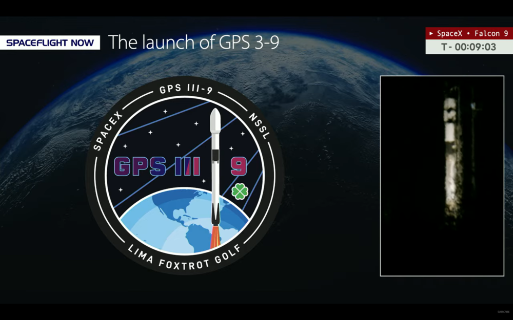
    Update: The ninth GPS III satellite was successfully launched into orbit Tuesday.

    Pre-launch report

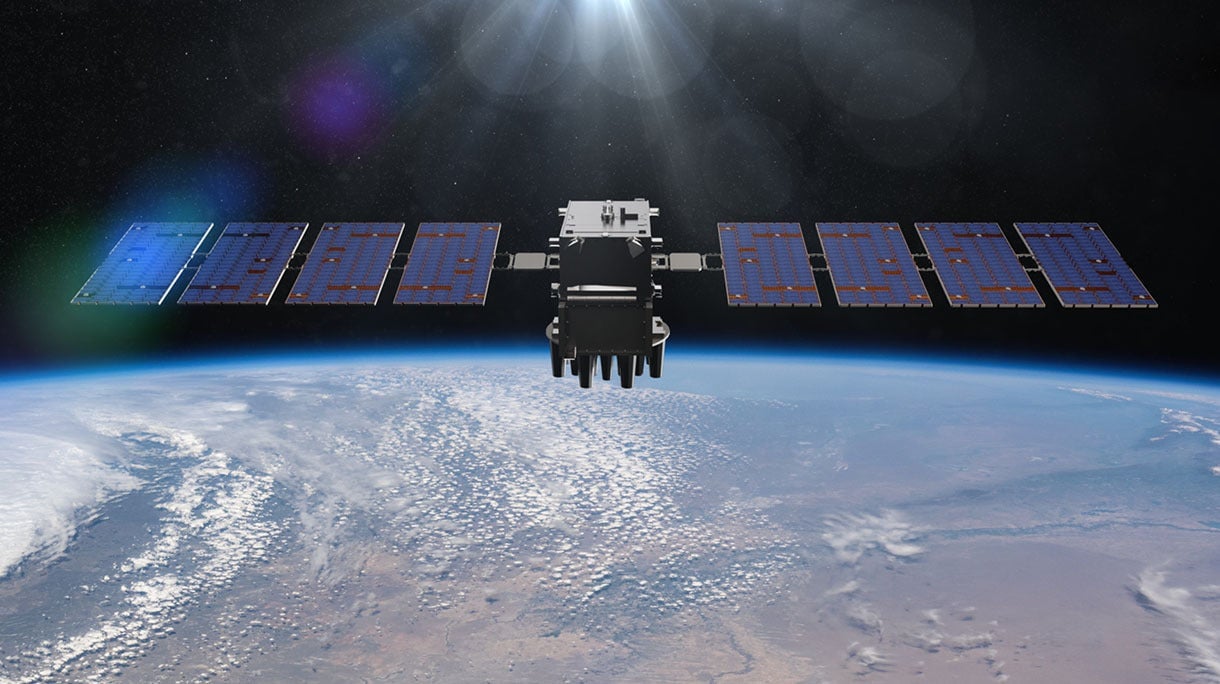
    GPS III Space Vehicle SV09 is being prepped for launch from Space Launch Complex (SLC)-40 at Cape Canaveral Space Force Station, Florida, aboard a SpaceX Falcon 9 rocket.

    The launch, delayed from Jan. 25, is now scheduled for 11:38 p.m. ET on Tuesday, Jan. 27.

    A live webcast of this mission from launch to satellite deployment will begin about ten minutes prior to liftoff and can be watched on www.spacex.com/launches. The webcast will be shown on the X TV app, as well as various streaming outlets, including YouTube.com via SpaceFlight Now and NASASpaceflight.com.

    U.S. Space Force’s Space Systems Command (SSC) and Combat Forces Command (CFC) will launch SV09 as the next National Security Space Launch (NSSL). The two field commands are executing this mission using the model established by the Rapid Response Trailblazer launch in December 2024 and GPS III-7 (SV08) launch in May 2025. Being pre-postured with the right equipment has enabled the launch teams to process and integrate the GPS III (SV09) satellite with the Falcon 9 rocket on a shortened timeline, the Space Force said.

    GPS III satellites, equipped with M-code technology, provide the warfighter with a significantly more accurate and jam-resistant capability. Adding another such satellite to the constellation enhances the system’s robustness and ultimately boosts the warfighting lethality of the Joint Force.

    “For this launch, we traded a GPS III mission from a Vulcan to a Falcon 9, then exchanged a later GPS IIIF mission from a Falcon Heavy to a Vulcan,” said USSF Col. Ryan Hiserote, SYD 80 Commander and NSSL program manager. “Our commitment to keeping things flexible – programmatically and contractually –means that we can pivot when necessary to changing circumstances. We have a proven ability to adapt the launch manifest to complex and dynamic factors and are continuing to shorten our timelines for delivering critical capabilities to warfighters.”

    The space vehicle was successfully delivered to Florida over-the-road on July 31, 2025. Now, CFC’s Mission Delta 31 is leading the pre-launch processing of the space vehicle, working alongside Lockheed Martin to integrate it onto the rocket and for launch in a faster timeline than in the past.

    “This mission represents an outstanding collaboration across multiple teams and agencies,” said U.S. Space Force Col. Stephen Hobbs, MD 31 commander. “It foot stomps our ability to rapidly deploy a high-value space asset, in this case, an additional M-Code-capable satellite that brings significant, immediate value to the Joint Force.”

    SV09 is named in honor of Col. Ellison Onizuka, a U.S. Air Force test pilot and NASA astronaut. Onizuka successfully flew on STS-51C, a space shuttle Discovery mission in January 1985. The naming of the satellite also honors his memory as one of the astronauts who perished during the launch of STS-51L aboard the space shuttle Challenger on Jan. 28, 1986.

    With the launch of SV09, the GPS III constellation gains another satellite equipped with significantly enhanced accuracy and jam-resistance, bolstering the capabilities of the Joint Force.

  • US Space Force cancels smallsat project for Resilient GPS program

    US Space Force cancels smallsat project for Resilient GPS program

    The U.S. Space Force has ended an exploratory effort to add smaller, lower-cost navigation satellites to strengthen the existing GPS constellation, reports Space News.

    The Space Force does not plan to move forward with on-orbit demonstrations of industy-designed smallsats under the Resilient GPS (R-GPS) program, which began in 2024. In September of that year, the Space Force selected Astranis, L3Harris Technologies and Sierra Space to develop concepts for small, cost-effective navigation satellites to increase GPS resilience, using an expedited “quick start” contract process.

    But funding for the next phase of the program was not included in the fiscal year 2026 budget because of higher Department of the Air Force priorities, according to the report.

    R-GPS was part of a broader push by the Pentagon to diversify satellite architectures amid concerns that spacecraft are vulnerable to interference or attack.

    The Space Force has not said whether it plans to pursue alternative positioning, navigation and timing (PNT) efforts in place of R-GPS.

    Lawmakers have repeatedly raised concerns about GPS vulnerability and have called for studies examining commercial low Earth orbit navigation services as potential complements or backups to GPS.

  • LEO satellites show promise in boosting navigation accuracy where GPS struggles

    LEO satellites show promise in boosting navigation accuracy where GPS struggles

    Low-Earth orbit (LEO) systems have emerged as a promising complement to GNSS, offering higher received power, better satellite geometry and broader spectrum options. Researchers aim to evaluate whether LEO-PNT can complement or enhance GNSS performance through large-scale simulations and design comparisons.

    Researchers from Tampere University and Universitat Autònoma de Barcelona published (DOI: 10.1186/s43020-025-00186-5) a comparative analysis in the December 2025 issue of Satellite Navigation. The study investigates how different LEO constellation configurations perform in positioning accuracy and interference robustness when operating alone or jointly with GNSS.

    Using semi-analytical modeling and 192,000 Monte Carlo simulations, the team evaluated 400 users across European regions in five outdoor scenarios. Key variables included carrier bands (1.5/5/10 GHz), effective isotropic radiated power (EIRP) levels and constellation geometry design.

    The team simulated multiple standalone and hybrid constellation architectures, analysing carrier-to-noise ratio (C/N0), geometric dilution of precision (GDOP), position dilution of precision (PDOP) and lower bound 3D accuracy.

    Results indicate that an EIRP of 50 dBm is sufficient for high-quality outdoor positioning when operating in L- and C-bands. While 10 GHz platforms require higher power to compensate for path loss, hybrid LEO + GNSS modes show markedly improved stability and reliability.

    Multi-shell constellations such as Çelikbilek-1 and Marchionne-2 delivered a favorable balance between satellite count and global geometry, outperforming single-shell layouts. In harsh urban canyon conditions, GNSS accuracy degraded up to seven-fold, whereas LEO-PNT maintained stable ranging performance with limited loss.

    Interference resistance also improved. Stronger LEO signal power means jammers require far greater intensity to cause equal degradation. Hybrid designs provided the most significant gains. Combinations such as Çelikbilek-1 + GPS/Galileo, or CentiSpace + BeiDou, yielded better PDOP distributions, faster fix availability and broader user coverage.

    The authors conclude that LEO systems are not aimed at replacing GNSS, but rather to enhance availability and resilience under signal-challenged environments.

    “Our results show that moderate-power LEO constellations can substantially strengthen outdoor positioning without requiring expensive satellite hardware,” the authors noted. “Geometry plays a major role — carefully designed multi-shell constellations achieve strong accuracy even with fewer satellites. As LEO-PNT develops, hybrid integration with GNSS offers the most cost-effective path toward secure, robust PNT solutions. This work provides guidance for future system designers evaluating frequency, transmission power and constellation configuration trade-offs.”

    The findings suggest a realistic rollout pathway for resilient satellite navigation. LEO-enhanced PNT could benefit autonomous vehicles, UAV routing, emergency response, precision farming and critical infrastructure monitoring — especially where GNSS falters in interference-dense or high-rise environments.

    Lower-power LEO transmission also reduces deployment cost, opening access for commercial operators.

    Future work may assess indoor positioning potential, bandwidth expansion, and real-orbit testing to refine simulation assumptions. As global demand for secure PNT grows, the integration of LEO and GNSS could become a cornerstone for next-generation navigation technology.

  • Moldova’s positioning system now uses Galileo

    Moldova’s positioning system now uses Galileo

    The MOLDPOS National Positioning System in Moldova has been integrated into the European Position Determination System (EUPOS),  a pan-European GNSS augmentation service.

    The MOLDPOS navigational system uses both GPS and GLONASS, and now Galileo has been added, according to Anatol Ghilas, director of the Agency of Land Relations and Cadastre (ALRC) of Moldova. Ghilas said the question of integration with the European system of Galileo was often discussed, and is a step forward in promoting the positioning technology.

    Creation of MOLDPOS was gradual. First, sites for placement of MOLDPOS stations were selected, then the stations were installed. Once installations were in place, the system was tested and launched. Now it is integrated into EUPOS.

    Moldova had been a member of the European Position Determination System since 2008.

    According to Norwegian Ambassador to Moldova Øystein Hovdkinn, Moldova and Norway are situated in opposite parts of Europe, but it did not impede establishing friendly relations. Norway provided financial aid to build MOLDPOS.

    Hovdkinn said that the Government of Norway supports the program of reforms in Moldova. The project’s goal is to promote Moldova’s development as a modern country and to promote its integration in Europe.

    According to Gheorghe Duca, president of the Moldovan Academy of Sciences, implementation of MOLDPOS will have a positive influence upon the country’s social, economic and scientific sectors.

    “A digital map is necessary for preventing floods, for rehabilitating roads, in agriculture and in science,” Duca said, adding that Moldova is the first country on the border with the European Union that will have digital maps, expected to be available in 10 months.

  • GPS Editorial Advisory Board: Expert takes on GNSS protection

    GPS Editorial Advisory Board: Expert takes on GNSS protection

    Among the technical approaches being researched this year for GNSS/PNT protection, which do you consider most effective or promising?

    Photo: Jules McNeff
    Photo: Jules McNeff

    “The simple answer is what I have been saying many times before. The most effective way to back up GPS/GNSS is to use the terrestrial technology available from eLoran.  It is affordable, long-range, precise and essentially unjammable. However, it’s not what I would call ‘promising’ because that’s not what the government wants to hear. In fact, the government is in the process of dismantling the existing Loran infrastructure that could easily be recapitalized as autonomous eLoran stations. eLoran could provide robust nationwide timing and positioning preservation, including in the northern Pacific Ocean and Alaska, as well as across the Arctic, with Canada, to link up with our allies in the UK and Europe, who are also investing in eLoran. There is no real commercial market in the far north and there are no commercial systems proposed that can provide such coverage in those areas where we are facing challenges from Russia and China today and that will only increase into the future.”

    Jules McNeff


    Allison Brown
    Allison Brown

    L-band jamming and spoofing is now prevalent in many parts of the world. It has now been confirmed that space-based jammers have been active, as well as conventional terrestrial jamming.  Anti-jam solutions can only provide protection up to a certain jammer power level and are not a ‘silver bullet’ solution. Moreover, nulling of space-based jammers will also have the effect of nulling parts of the sky where GPS satellites are in view, degrading performance by reducing DOP. Alternative PNT solutions that are not relying on L-band signals are the most effective solution for operations in highly contested, jammed or spoofed L-band environments.”

    Allison Brown


    Photo: Mitch Narins headshot
    Mitch Narins

    “I believe that both orbital and ground-based PNT systems, operating in tandem and integrated properly, are the ultimate solution for critical infrastructure applications, but to get there, ‘the budget-office-inspired problem’ of having to pick one and only one must be abandoned: prevention is usually cheaper than curation. Only after space-based and ground-based PNT designers, developers, regulators and users understand and welcome the essential nature of PNT source diversity will we actually achieve the resilient PNT capabilities that we all need.”

    Mitch Narins

  • Pathfinder provides signal-resilient autonomy in navigation

    Pathfinder provides signal-resilient autonomy in navigation

    Aero Drop Systems (ADS) has developed Pathfinder, a proprietary autonomous navigation framework designed to reduce dependence on GNSS-based positioning. Pathfinder is signal-resilient, capable of maintaining precision even in complete GNSS dead zones and unaffected by deceptive interference.

    At the core of Pathfinder lies an array of sensors and advanced self-regulating logic driven by machine learning. Unlike traditional systems that treat GPS as a singular source of truth, Pathfinder fuses a constant stream of information from multiple internal and external domains and dynamically rebalances itself in real time as it evaluates, cross-verifies, and refines its positional understanding based on an algorithm that classifies the trustworthiness of each data stream.

    The result is a self-correcting navigation intelligence that can anticipate changing conditions, isolate false data, and continue to perform when other systems cannot. This allows Pathfinder to sustain highly accurate navigation during satellite connection or radio frequency outages or when being targeted with jamming or spoofing.

    Designed as a modular framework, Pathfinder can be integrated across a range of fully autonomous platforms operating on land, at sea, or in the air. Its flexible architecture makes it suitable for both commercial logistics and defense applications, where navigation integrity is critical to mission success.

    Currently in the testing phase, Pathfinder is part of ADS’s broader initiative to develop resilient, autonomous logistics technologies capable of performing in contested and complex environments. ADS has confirmed that Pathfinder will serve as the core navigation technology for the platform Aerocrate. Aerocrate is a disposable, autonomous aerial delivery system that enables precise, reliable resupply without requiring recovery operations, staging areas, or active communication with the platform.

  • LuGRE mission: NASA and ASI release lunar experiment navigation data

    LuGRE mission: NASA and ASI release lunar experiment navigation data

    During a public workshop at the Italian Space Agency on Oct. 14-15, the Lunar GNSS Receiver Experiment (LuGRE) project team celebrated the closure of the project and released the data collected to the scientific community. 

    LuGRE, developed in partnership by NASA and the Italian Space Agency (ASI), flew to the Moon a GNSS receiver manufactured by the Italian company Qascom. The receiver was hosted aboard the Firefly BGM1 mission.

    LuGRE demonstrated that signals from GNSS satellite constellations can also be used for positioning, navigation and timing (PNT) on the Moon.

    The Navigation Signal Analysis and Simulation of the Dept. of Electroncis and Telecommunications of Polytechnic University of Turin processed the data received during the mission and contributed to all the science team activities, including the validation of the data and the processing of the initial set of scientific results.

    The full set of data collected during the space mission, which took place between Jan. 16 and March 16, is now available.

    An artist’s concept of the LuGRE payload on Blue Ghost and its three main records in transit to the Moon, in lunar orbit and on the Moon’s surface. (Image: NASA/Dave Ryan)
    An artist’s concept of the LuGRE payload on Blue Ghost and its three main records in transit to the Moon, in lunar orbit and on the Moon’s surface. (Image: NASA/Dave Ryan)

    Launched on Firefly Aerospace’s Blue Ghost lander in January, LuGRE became the first payload to use Earth’s GNSS to calculate a navigation fix on the lunar surface and in lunar orbit. The experiment set a series of distance records on its journey to the Moon, demonstrating that GNSS technology can complement other navigation tools as far as 247,520 miles (398,350 km) from Earth.

    These results point to a future where lunar astronauts, rovers and spacecraft can rely on the same satellite-based navigation systems we use every day to augment their navigation capabilities.

    “It is a very important milestone for the satellite navigation community,” said Fabio Dovis, Politecnico di Torino, Italian Space Agency, of the project. “For the first time we have the recording of signal of the GPS and Galileo constellation collected in space and on the Moon surface. Already during the LuGRE mission we proved the feasibility of using satellite systems originally designed to be used on Earth up to lunar distances. Now the entire scientific community can use them to ‘re-play’ the space environment as well as analyze them in depth, for example, to retrieve information about the Earth atmosphere crossed by the signal themselves.”

    Artistic rendering of LuGRE and the GNSS constellations. In reality, the Earth-based GNSS constellations take up less than 10 degrees in the sky, as seen from the Moon. (Image: NASA/Dave Ryan)
    Artistic rendering of LuGRE and the GNSS constellations. In reality, the Earth-based GNSS constellations take up less than 10 degrees in the sky, as seen from the Moon. (Image: NASA/Dave Ryan)

    The data release includes the actual GPS and Galileo radio signals LuGRE captured during its journey and on the lunar surface. The raw recordings — called in-phase and quadrature (I/Q) samples — allow researchers to analyze GNSS signal strength, noise and interference under lunar conditions for the first time. Engineers and scientists will use these results to model and refine the next generation of GNSS-based signal receivers and improve our understanding of how navigation signals operate at the Moon.

    Graphic representation of the relative geometry of Earth-Moon- acquired GNSS satellites. (Photo: Agenzia Sapaziale Italiana)
    Graphic representation of the relative geometry of Earth-Moon-acquired GNSS satellites. (Image: Agenzia Sapaziale Italiana)
  • L3Harris demonstrates reprogrammable PNT system for US Space Force

    L3Harris demonstrates reprogrammable PNT system for US Space Force

    L3Harris has demonstrated a positioning, navigation and timing (PNT) solution for the U.S. Space Force’s Space Systems Command that is adaptable across platforms, fully reprogrammable on orbit and scalable to support more signals and increased power as PNT threats evolve. According to L3Harris, the solution is designed to provide the Space Force with the flexibility to deploy smaller, multi-launch-capable satellites, thereby strengthening or diversifying its satellite constellation.

    During a two-day design concept review, L3Harris presented a resilient-GPS (R-GPS) prototype that exceeded current requirements, highlighting its potential to accelerate the Space Force’s roadmap for a stronger, more adaptable PNT infrastructure. Using the Navigation Technology Satellite-3 reprogrammable payload and NSA-certified cryptography, the company simulated the operation of an R-GPS satellite transmitting navigation signals. These signals were successfully acquired and tracked by monitoring stations, military receivers and commercial equipment, demonstrating that R-GPS technology can be seamlessly integrated into the existing GPS framework.

    “Our team transmitted, tested and validated a core set of R-GPS signals across the entire enterprise to demonstrate a fully reprogrammable, resilient PNT solution for the Department of Defense,” said Ed Zoiss, president of Space and Airborne Systems at L3Harris. “We leveraged best-in-class commercial technology and the government’s investment in NTS-3 PNT technologies.”

    L3Harris followed a “prototyping with purpose” approach that showcased maturity far beyond a traditional Preliminary Design Review, resulting in a low-risk, achievable plan for the future development phases of the R-GPS program. The L3Harris R-GPS design includes capabilities aligned to future Lite Evolving Augmented Proliferation, providing an opportunity for roadmap acceleration and reduction in lifecycle costs. 

    “Our approach supports satellite design verification, proves compatibility with the Control Segment and user equipment, and enables early integration opportunities,” Zoiss said. “After more than five decades in the field, we understand the challenges in aligning the Space, Control and User segments of the GPS enterprise, so we used a holistic, unified approach.”

    The Design Concept Review demonstrated how the L3Harris R-GPS satellite can minimize impact on existing control systems while maintaining backward compatibility with current and future user equipment. In 2024, L3Harris was selected to design concepts for Phase 0 of the R-GPS program through the Space Enterprise Consortium, which the National Security Technology Accelerator manages. The agile R-GPS satellite program aims to reduce costs by launching eight smaller, more advanced space vehicles simultaneously, allowing the United States to quickly modernize GPS.

  • ESA and Neuraspace work to minimize signal noise through GNSS advances

    ESA and Neuraspace work to minimize signal noise through GNSS advances

    Neuraspace is working with the European Space Agency (ESA) to use innovative GNSS technologies to minimize signal noise under a new NAVISP project. Neuraspace is an expert in space domain awareness (SDA) solutions,

    “Stop Getting Noise – Automated GNSS Processing for Smarter Orbits” (NAVISP Element 2) seeks to address critical operational challenges faced by commercial satellite operators, launch service providers and defense and government agencies.

    Challenges to be addressed include the urgent need for more scalable, accurate and autonomous orbit determination, particularly for satellite mega-constellations, in an increasingly congested space environment. While defense and government agencies demand high-confidence SDA solutions amid increasing geopolitical tensions, satellite operators require reliable orbit tracking and early mission support.

    The result is expected to use innovative GNSS technologies to reduce the risk of satellite collisions and enable satellite operators to make faster and more accurate decisions about safekeeping their assets. Solutions will also lead to more efficient operations with lesser reliance on ground infrastructure and smarter fuel management translating into lower mission costs.

    In particular, the project includes:

    • GNSS Data Cleanup to remove biases and noise to improve the precision of orbit determination.
    • GNSS Orbital Phase Correction by introducing lightweight onboard algorithms designed to run on resource-constrained satellite systems. The algorithms will use real-time data to enable satellites to autonomously correct trajectory predictions and minimize reliance on ground stations, saving time and resources.
    • GNSS Orbit Determination Accuracy to provide better orbit predictions by developing advanced methodologies to deliver critical positioning information for safe operations and maneuver planning.
  • Advanced Navigation develops laser-aided inertial intelligence

    Advanced Navigation develops laser-aided inertial intelligence

    Advanced Navigation has successfully demonstrated a hybrid solution — AdNav OS Fusion — for long endurance GNSS-denied navigation, a software-fused inertial-centered architecture that can be updated or modified for harsh environments and mission requirements, including on the moon.

    This advancement is achieved by integrating a strategic-grade fiber-optic gyroscope (FOG) inertial navigation system (INS) with a new class of navigation aid: a laser velocity sensor (LVS). The result is a fused hybrid architecture that delivers precision and reliability in even the most challenging environments.

    Advanced Navigation’s FOG INS, which is sensitive enough to detect the Earth’s rotation, provides that foundation by delivering precise attitude. Complementing this, the company’s LVS uses infrared lasers to measure a vehicle’s ground-relative 3D velocity with exceptional accuracy and long-term stability. Unlike conventional sensors, LVS performs reliably on both ground and airborne platforms, as long as it maintains a clear line of sight to the ground or a stationary surface.

    Beyond its role as a velocity aid, LVS also enhances navigation resilience by detecting GNSS spoofing. By comparing its independent velocity measurements against GNSS-derived velocity, LVS adds an extra layer of security to assured positioning, navigation, and timing (APNT) strategies.

    AdNav OS Fusion draws on sophisticated algorithms to interpret and filter sensor data. The software is designed to dynamically weigh the input from each sensor, adjusting in real time based on reliability scores, environmental conditions and operational context. This ensures continuous, high-confidence state estimation even when signals are lost, degraded or distorted.

    Demonstration with real-world data

    Advanced Navigation conducted a series of rigorous real-world driving tests. Across five trials, the system delivered exceptional performance with an average error per distance traveled of 0.053% compared to a GNSS reference. 

    At the starting point, GNSS on the INS was disabled in the state estimation process, forcing the system into dead-reckoning mode. RTK GNSS was logged separately as a reference. This approach allows for a direct comparison between the computed dead-reckoning solution and a trusted position reference.

    The below data shows dead-reckoning results from a 23 km drive around Canberra, Australia. GNSS was not used at any point in the drive for heading or position. RTK GNSS is shown as the red line, while the hybrid system’s result is shown in blue.

    The below results are from a 19.2 km drive around the Parliamentary Triangle in Canberra, Australia. GNSS was not used at any point in the drive for heading or position. RTK GNSS is shown as the red line, while the Hybrid system’s result is shown in blue.

    The below results are from a 19.2 km drive around the Parliamentary Triangle in Canberra. GNSS was not used at any point in the drive for heading or position. RTK GNSS is shown as the red line, while the hybrid system’s result is shown in blue.

    Image showing Boreas INS and LVS data.

    The figure below is a zoomed section from the first test drive, showing GNSS (red) drop out as the test vehicle drove through a tunnel, which completely denied the GNSS reference measurement. The hybrid system’s result can be seen in blue, showing it did not suffer from this error.

    Image showing Hybrid solution and GNSS route comparison

    These drives were done repeatedly, demonstrating consistent and reliable results each time.

    Test drive results of LVS and INS

    The hybrid system was also tested on a fixed-wing aircraft combined with a tactical-grade INS, demonstrating a final error per distance traveled of 0.045% over the course of a low-altitude flight over 545 km. These results demonstrate the system’s impressive ability to improve navigation performance of the INS in GNSS-denied or contested scenarios. For a more in-depth look into the technology, read the white paper here.

    Commercializing space to Earth

    LVS is a terrestrial adaptation of LUNA (Laser Unit for Navigation Aid), a space-grade navigation technology developed for autonomous lunar landings. LUNA enables reliable navigation in the harsh environment of space by providing precise three-dimensional velocity and altitude information relative to the Moon’s surface. The result of several years of research and development, LUNA is set to be demonstrated aboard Intuitive Machines’ Nova-C lander as part of NASA’s Commercial Lunar Payload Services (CLPS) program.

    By leveraging the engineering insights gained from LUNA, LVS adapts space technology into an Earth-ready solution for terrestrial GNSS-denied navigation.

  • GNSS/GPS signal integrity in autonomous systems: Key issues and solutions

    GNSS/GPS signal integrity in autonomous systems: Key issues and solutions

    Question: What are the main challenges facing GNSS/GPS-based autonomous solutions in terms of signal integrity, jamming and spoofing, and how are these being addressed?

    Answer: Outside of the military, interference is the most common threat to GNSS, with the dominant source being cellular transmission harmonics. It is commonly addressed with out-of-band filters. Non-terrestrial networks (NTN), like Global Star uplink at 1.6 GHz, are gaining traction in more mobile and wearable devices to fill gaps in cellular availability. However, it can create coexistence issues for devices for concurrent L1 GNSS reception during NTN uplink.

    In military cases, while intentional interference is effective, the increasing number of GNSS bands to cover requires more transmission power. Modernized GNSS signals with wider bandwidth signals require more jamming power, which risks detection by radiofrequency emission satellite systems such as Hawkeye 360. The frequency of spoofing events will likely continue to increase and spill over into civilian domains.

    Thanks to the increasing number of test ranges being made available to commercial GNSS developers, anti-spoofing technology is making some gains, at least in the high-end systems used for autonomous GNSS.

    Q: What are the most impactful use cases and sectors benefiting from recent advancements in autonomous solutions?

    A: Ride sharing and transport are the likely winners in exploiting the cost savings of driverless systems with autonomous navigation. The past 15 years’ investments in the development of augmented navigation systems — mainly lidar and vision-based — are finally paying off as we see Waymo in service, and soon Uber and Tesla in commercial deployments. Still, these systems depend solely on GNSS as the absolute positioning system, used for navigation in non-urban environments, but also fallback in certain cases where the sensors are problematic, as well as system calibration.

    Agriculture, being one of the first segments to exploit autonomous solutions, can still see incremental gains as GNSS corrections systems move RTK from local to regional, allowing some monthly service margin improvements. High-precision consumer products like robotic lawn mowers will be enabled with similar infrastructure. Data services are a key part of infrastructure, for communication as well as precision navigation enablement. Companies such as Swift Navigation, Point One Navigation and RxN networks are expanding their networks and competing with the likes of Trimble and Hexagon.

  • Sierra Space demonstrates resilient GPS technology for US Space Force

    Sierra Space demonstrates resilient GPS technology for US Space Force

    Sierra Space, a commercial space and defense technology company, has successfully completed another demonstration of its resilient GPS (R-GPS) technology for the U.S. Space Force. This achievement marks the third major milestone for the program, which is designed to enhance the resilience of GPS infrastructure against threats such as jamming and spoofing. The recent demonstration included early integration of R-GPS satellite technology using FlatSat flight software and hardware subsystem testing, as well as successful communication with ground software systems.

    The R-GPS effort is part of a broader initiative by the U.S. Space Force’s Space Systems Command to develop smaller, more cost-effective GPS satellites. Sierra Space was awarded a Quick Start contract in September 2024 to produce design concepts for these satellites, aiming to rapidly bring advanced technology to the national security space sector. The company’s progress comes just six months after the program’s inception, highlighting its ability to accelerate technology development in response to evolving defense needs.

    GPS technology is integral to both civilian life and military operations, supporting applications that range from smartphone navigation to critical defense activities. As adversarial threats become more sophisticated, the need for resilient GPS systems has grown. The R-GPS program addresses this by planning to augment the existing GPS architecture with a network of smaller satellites, which would provide additional layers of security and rapid deployment capabilities.

    The latest testing milestone demonstrated the flow of commands and telemetry between Sierra Space’s ground software and a ground stations service provider, establishing that the technology can operate effectively between orbit and ground-based facilities. The FlatSat testing format, where satellite components are evaluated while laid out flat, allowed for early integration of flight software and hardware subsystems.