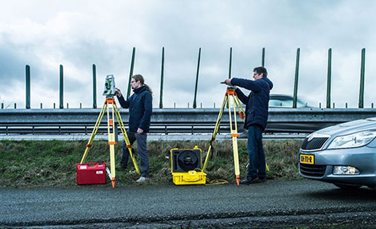
Position Partners has unveiled SmartSurveyor, which facilitates accurate, survey-grade aerial mapping and photogrammetry without the need for a connection between a camera shutter and a GNSS receiver.
The fully compact, handheld, aerial mapping survey rover is compatible with DJI Mavix 2 and 3 series and Phantom 4 Pro drones.
Image: Position Partners
The design is dissimilar to other drone mapping systems in that it works from a drone or smartphone and with two or more ground control points (GCPs) while using an ultra-matching technique.
Once data is captured by SmartSurveyor, all the photos and the GNSS file are uploaded to a PC and analyzed through the Agisoft UltraMatch workflow to confirm their accuracy before they are exported. Data can be managed in the cloud or on a local PC using software designed by MapSender.
Additionally, this mapping tool works in tandem with the AllDayRTK subscription GNSS network service so collected data can be uploaded to Tokara to remotely manage a project.
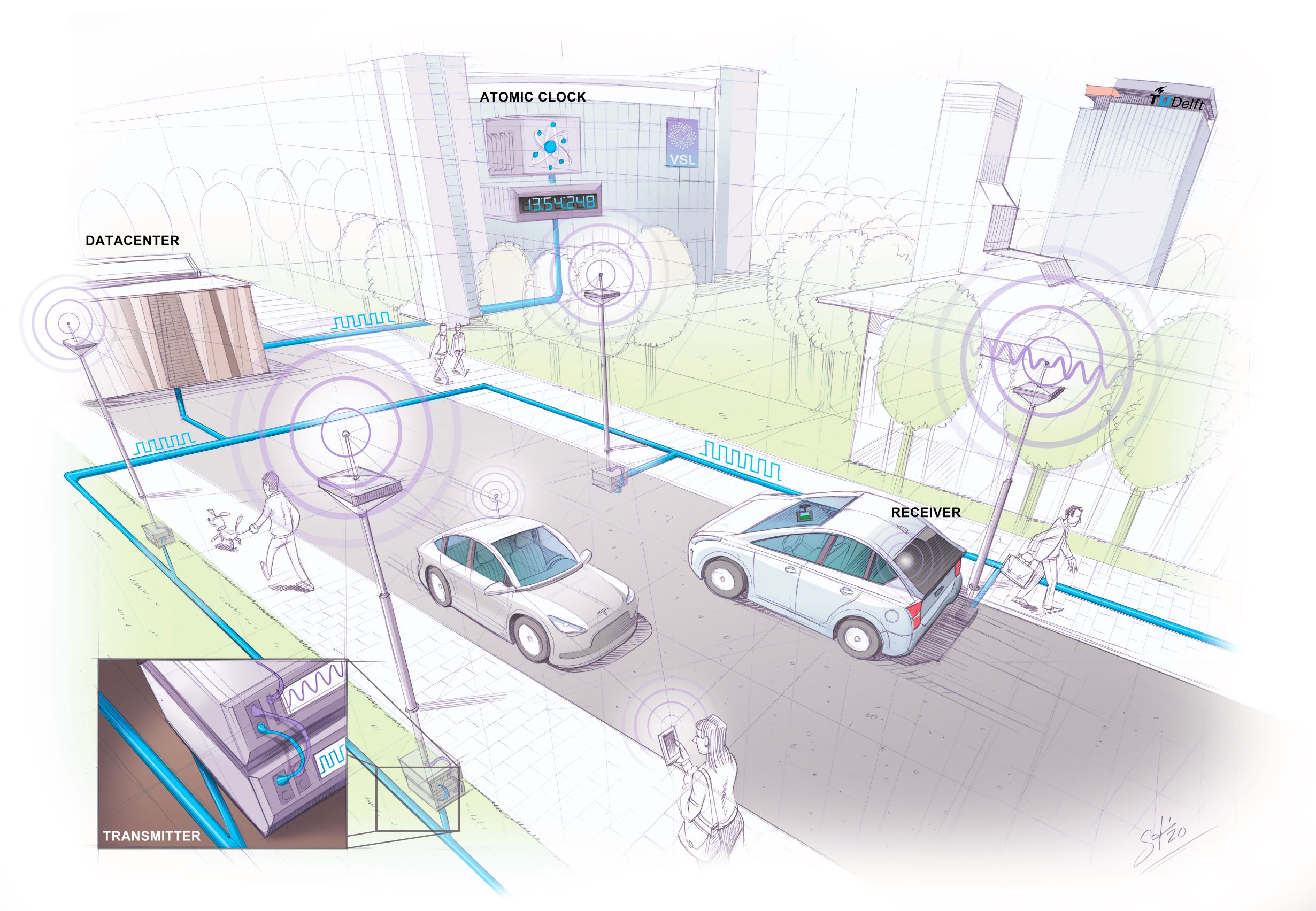
Researchers at Delft University of Technology, Vrije Universiteit Amsterdam and VSL have developed an alternative positioning system that is more robust and accurate than GPS, especially in urban settings.
The aim of the project — SuperGPS — was to develop an alternative positioning system that makes use of the mobile telecommunication network instead of satellites and that has better accuracy than GPS.
The working prototype that demonstrated this new mobile network infrastructure achieved an accuracy of 10 centimeters.
The new technology is important for the implementation of a range of location-based applications, including automated vehicles, quantum communication and next-generation mobile communication systems.
Much of our vital infrastructure relies on GNSS. Yet systems that rely on satellites have limitations and vulnerabilities. For instance, their radio signals are weak when received on Earth, making accurate positioning no longer possible if the radio signals are reflected or blocked by buildings.
“We realized that with a few cutting-edge innovations, the telecommunication network could be transformed into a very accurate alternative positioning system that is independent of GPS,” said Jeroen Koelemeij of Vrije Universiteit Amsterdam. “We have succeeded and have successfully developed a system that can provide connectivity just like existing mobile and Wi-Fi networks do, as well as accurate positioning and time distribution like GPS.”
Illustration: TU Delft / Stephan Timmers
One innovation is to connect the mobile network to a very accurate atomic clock so that it can broadcast perfectly timed messages for positioning, just like GPS satellites do with the help of the atomic clocks they carry on board. These connections are made through the existing fiber-optic network.
“With these techniques, we can turn the network into a nationwide distributed atomic clock — with many new applications such as very accurate positioning through mobile networks,” said Erik Dierikx, VSL. “With the hybrid optical-wireless system that we have demonstrated now, in principle anyone can have wireless access to the national time produced at VSL. It basically forms an extremely accurate radio clock that is good to one billionth of a second.”
The system also employs radio signals with a bandwidth much larger than commonly used. “Buildings reflect radio signals, which can confuse navigation devices. The large bandwidth of our system helps sorting out these confusing signal reflections, and enables higher positioning accuracy,” explained Gerard Janssen of Delft University of Technology. “At the same time, bandwidth within the radio spectrum is scarce and therefore expensive. We circumvent this by using a number of related small bandwidth radio signals spread over a large virtual bandwidth. This has the advantage that only a small fraction of the virtual bandwidth is actually used and the signals can be very similar to those of mobile phones.”
The results of the peer-reviewed research have been published in Nature.
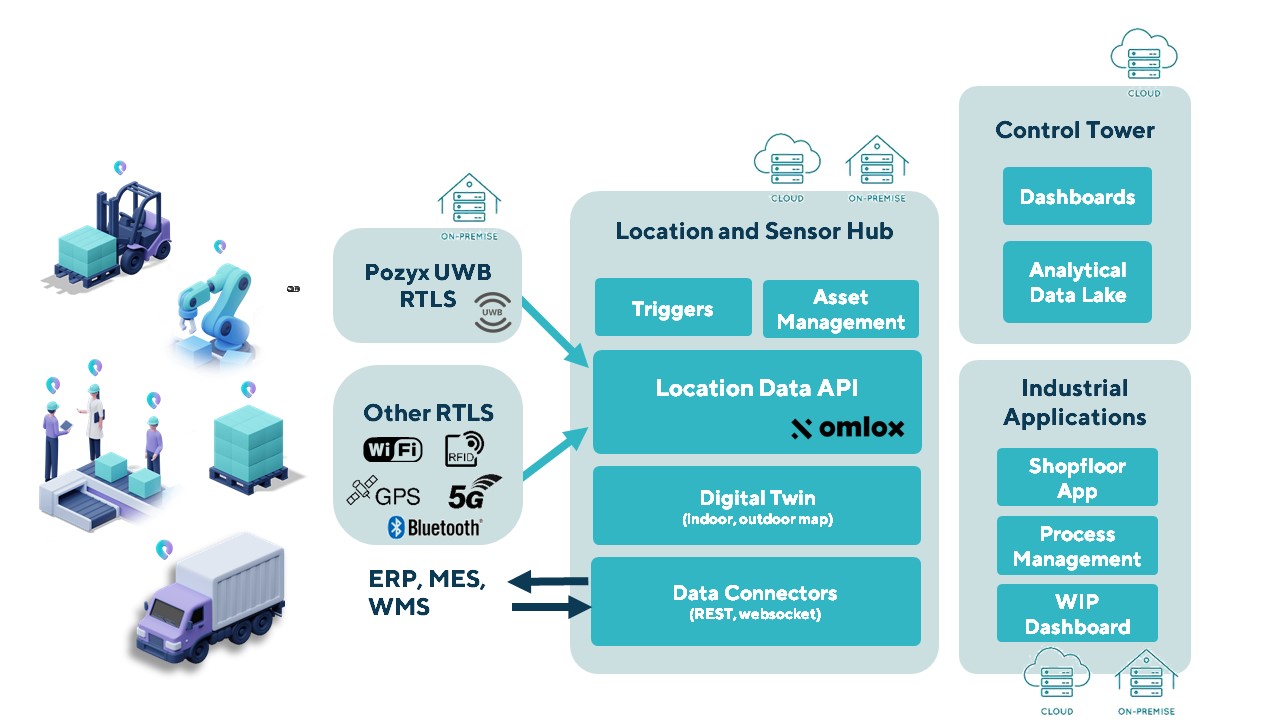
The Pozyx Platform is an asset tracking and identification solution for seamless indoor and outdoor tracking, based on the omlox hub and supporting multiple location technologies.
The omlox hub is an open standard for real-time location systems (RTLS) that combines location data from GPS, ultra-wideband, 5G, radio-frequency identification, Wi-Fi and Bluetooth.
The Pozyx Platform offers a seamless indoor/outdoor transition with zoom-in from a worldwide map to a detailed indoor map, showing highly accurate locations up to 10 cm. It is designed for smart manufacturing, providing a supply-chain solution that supports Industry 4.0.
It tracks and identifies any asset, providing real-time data to facilitate warehouse and inventory control, keep track of critical tools, and slash lost asset costs.
A new surveying and mapping textbook is now available on the OPEN Textbook network.
Written in English, the book provides an academic introduction to the field of surveying and mapping. It is based on handouts and readers written for the third-year course “Surveying and Mapping” in the civil engineering bachelor’s program at Delft University of Technology in The Netherlands.
The textbook covers a wide range of measurement techniques, from land surveying using GPS/GNSS and remote sensing to the associated data processing, the underlying coordinate reference systems, and the analysis and visualization of the acquired geospatial information.
Although a few parts of the book are specific to The Netherlands, for the most part the material is applicable globally.
Surveying and Mapping
Authors: Christian Tiberius, Hans van der Marel, René Reudink and Freek van Leijen / Delft University of Technology / The Netherlands
Knowing your position is only part of navigation. (Photo: Oliver Montenbruck)
By Oliver Montenbruck and Peter Steigenberger
A year ago, the U.S. Global Positioning System celebrated its silver jubilee upon completing 25 years in operation. Also, it was more than 20 years ago that President Clinton agreed to switch off Selective Availability, thus offering seamless positioning to the civil community. The 10-bit GPS week count experienced its second rollover, and people worldwide got addicted to a ubiquitous positioning capability in those decades. Be it for finding the nearest restaurant or to track a Sunday afternoon bike ride, positioning-related services building on GPS have become an integral part of our daily life. In fact, GPS has almost become a synonym for navigation itself.
One cannot underestimate the contribution that GPS has made to society. It is for sure most deserved that the fathers of GPS were ultimately awarded the highly prestigious Queen Elizabeth Prize for Engineering in the year of the above jubilee. As always, success creates followers, and GPS is no longer the sole player. Next to the Russian GLONASS, two new actors — namely the European Galileo and the Chinese BeiDou-3 GNSS — have mounted the stage. So, users are now offered a choice of four independent GNSS.
However, do we really need so many systems? Isn’t one enough and all others just a waste of taxpayers’ money? The answer to the last question is certainly a clear “no.” Our society already depends on, to a large extent, the availability of positioning, navigation and timing (PNT) services in much the same way we depend on electricity and telecommunication. While mass-market applications such as the ones mentioned above may appear dispensable, there are “hidden” but much more critical applications of GPS, such as synchronizing power lines, stock trading or the base stations of cellular networks.
Clearly, there is a well-justified rationale for nations or groups of nations to build their independent, space-based navigation systems. Well beyond possible military considerations, this is a basic strategic interest for protection of the local economy and of critical infrastructure. Along with these interests, various regulatory conditions may apply that only endorse the use of selected systems for specific applications, such as emergency call systems. Overall, however, all GNSS in place today can be received and utilized by all interested users around the globe.
So, let’s have a closer look at the practical relevance and implications of having four GNSS in parallel for both mass-market and high-end users. The most obvious consequence is certainly an almost four-fold increase in the number of satellites. As of today, the four GNSS comprise more than 100 satellites, out of which 30 to 40 are simultaneously visible and available for positioning at common sites with open-sky conditions. As a rule of thumb, this provides a factor-of-two reduction of statistical errors compared to using only GPS.
Most importantly, however, the prospects for tracking enough satellites for positioning in obstructed sites is greatly improved. The larger number of visible satellites is particularly appealing for GNSS radio scientists who aim to derive temperature and humidity profiles from subtle variations in GNSS signals passing through diverse atmospheric regions. Multiple GNSS allow for better resolution and ultimately benefit weather forecasts.
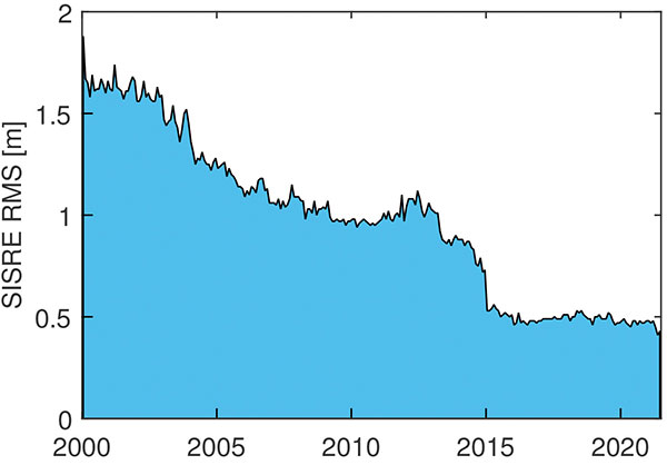
In terms of positioning, the simple statistical benefits of tracking a large number of satellites are probably outweighed by technological advances in GNSS satellites and ground systems, as well as substantial progress in receiver technology. For GPS, the signal-in-space range error (SISRE) that describes the contribution of broadcast orbit and clock errors to the position accuracy has decreased by more than a factor of three (Figure 1).
FIGURE 1. Evolution of the GPS signal-in-space range error over time. (Image: O. Montenbruck and P. Steigenberger)
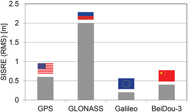
For GPS, but also Galileo and BeiDou-3, the use of highly stable atomic frequency standards has contributed to a notable reduction of the error budget of broadcast ephemerides. The same applies for fast upload capabilities, as in Galileo, or the use of intersatellite links in BeiDou-3. With SISRE values of 0.1–0.2 m and 0.3–0.4 m, these constellations enable even more accurate positioning today than GPS and GLONASS (Figure 2).
Figure 2. Signal-in-space ranging errors of the four GNSS. (Image: O. Montenbruck and P. Steigenberger)
However, improvements from new signals and multiple constellations are not only limited to single-point positioning, but likewise apply for precise point positioning (PPP) users. Stable clocks onboard the satellites reduce the update rate and bandwidth for real-time correction users. Digital signal generation units in modernized satellites ensure clean chip shapes in the transmitted ranging signals and reduce the scatter of satellite/receiver biases. Last but not least, the increased number of tracked satellites contributes notably to reducing the convergence time required for successful ambiguity fixing.
Concurrent progress in receiver technology was certainly a prerequisite for being able to track the multitude of new signals that became available with the new and modernized constellations. Compared to early GPS receivers with a few tens of channels, modern geodetic receivers may (or even must) support in the order of 1,000 channels. For mass-market users, the recent introduction of dual-frequency chipsets for mobile phones and car navigation systems marks the most important step forward. These chipsets support joint tracking of signals from GPS, Galileo and BeiDou-3 at the common L1/E1/B1 and L5/E5a/B2a center frequencies. The signals’ chipping rates, modulations and signal power are designed to offer reduced measurement noise, better multipath protection, and improved weak-signal tracking. At the same time, the use of two signal frequencies allows for rigorous elimination of ionospheric path delays, thus removing the biggest contributor to the error budget of low-cost positioning devices.
All in all, the availability of four GNSS means better performance, robustness, diversity and flexibility for navigation users. We should not forget, however, that all GNSS use basically the same core technology and share the same vulnerabilities. We must still give due attention to the challenge of toughening, augmenting and complementing GNSS to meet society’s needs for robust and assured PNT.
Oliver Montenbruck is the head of the GNSS Technology and Navigation Group and Peter Steigenberger is a senior scientist at the German Space Operations Center, German Aerospace Center (DLR).
Three decades after it first entered popular culture during the Gulf War, even a cursory review of articles about GPS aimed at a mass audience still will reveal a plethora of inaccuracies and misunderstandings, ranging from the trivial to the fundamental. Among my pet peeves, some for 20 years, are statements to the effect that GPS:
1. is a tracking technology
2. is the only such system
3. is responsible for routing errors
4. can operate indoors
5. receivers “talk” to the satellites
6. relies on triangulation
7. has 24 satellites in orbit
(For those of you picking up this magazine who are new to satellite navigation, the correct versions of those statements are below.)
Matteo Luccio
Additionally, GPS is taken for granted, with hardly any recognition for the engineers, technicians, U.S. Air Force service members and others who make the miracle happen, and for the fact that U.S. taxpayers foot the nearly $2 billion annual bill for the system, which is offered free to users worldwide. (All GPS program funding comes from general U.S. tax revenues. The bulk of the program is budgeted through the U.S. Department of Defense, which has primary responsibility for developing, acquiring, operating, sustaining and modernizing GPS. The U.S. Department of Transportation is responsible for funding the extra costs associated with new, civilian GPS upgrades beyond the second and third civil signals, and agencies with unique GPS requirements are responsible for funding them.)
While not as deadly as those about vaccines or as consequential as those about elections, misstatements about GPS lead to public confusion about threats to privacy and threats to the system. To help secure GPS, it behooves those of us who understand it the most to help educate the rest about it and correct misstatements, misunderstandings and misperceptions.
Tracking a person, vehicle or other object requires pairing a GPS receiver with a transmitter, typically a cellular phone.
It is one of four complete global navigation satellite systems (GNSS), the other three being the Russian GLONASS, the European Galileo and the Chinese BeiDou-3. There are also two regional systems, one Indian and one Japanese.
Routing errors are caused by bad map data or bad routing algorithms.
It requires a clear view of at least four satellites, unimpeded by terrain, buildings, roofs or even dense tree canopies.
GPS receivers are just that and have neither the need nor the ability to transmit messages back to the satellites.
Triangulation determines position by measuring angles. By contrast, GNSS determine position by measuring distances (between receivers and satellites), which is called trilateration.
The are currently 30 operational GPS satellites and the number varies as some satellites are temporarily removed from service, older ones are decommissioned, and new ones are placed in orbit. Find the current status of the constellation here.
The research satellite will in collecting high-quality, high-resolution data for terrestrial, coastal and ocean ecosystems for a three-year period after launch, according to Matthew McCabe, director of the KAUST Climate and Livability Initiative. McCabe described the launch as a qualitative process for the Kingdom’s efforts in the field of protecting and restoring ecosystems on land and at sea.
A CubeSat is a small satellite consisting of one or several 10x10x10 cm units, no more than 1.33 kilograms per unit. CubeSats can range from 1 unit (1U) to 12 units (12U). The KAUST satellite is 6U.
“In the past, launching a satellite was the sole domain of governments, with costs well beyond the reach of a university,” McCabe said. “CubeSats are helping to democratize space, providing the opportunity to launch a customized platform at a fraction of the traditional cost.”
The data collected will provide high-resolution details about current conditions of ecosystems in the region, and monitor improvements from environmental management strategies, supporting the Saudi Green Initiative among others.
The CubeSat is equipped with Spire’s GNSS reflectometry reflectors, as well as a hyperspectral imaging sensor. It is supported by advanced capabilities in processing and artificial intelligence.
The satellite will allow KAUST University researchers collect and analyze high-resolution images of the Earth’s surface for detailed mapping of terrestrial environments, monitoring of vegetation cover status, exploration of coastal ecosystems and coral reefs, development of precision agricultural research, and a host of other Earth and environmental science applications.
The imaging sensor can image areas of interest anywhere in the world across more than 30 user-adjustable spectral bands. The sensor data can be combined with Spire’s GNSS receiver to monitor micro-environmental variables such as soil moisture, helping in many areas such as agriculture, forestry and land management.
“The capacity to observe the Earth in high-resolution hyperspectral detail will allow for the production of enhanced metrics to map and monitor change anywhere in the world,” McCabe said. “Closer to home, Saudi Arabia is focusing considerable effort towards the protection and restoration of its precious terrestrial and ocean systems. The data from this KAUST CubeSat will be invaluable in providing new information on both the state of existing ecosystems, and for monitoring changes resulting from improved management strategies – something that can be used to support aspects of the Saudi and Middle East Green Initiatives.”
The Indian Institute of Technology (IIT) Roorkee is offering a free online course on GNSS and Applications on the NPTEL platform. The four-week course will provide a basic understanding about digital elevation models (DEMs) and their applications in civil engineering and Earth sciences.
During the course, various DEMs and their sources, generation techniques, derivatives, errors and limitations will be discussed extensively. Surface hydrologic modeling using DEMs, modeling derivatives and their applications will also be discussed.
Intended audience. Under- and post-graduate engineering and post-graduate science students and faculty.
Pre-requisites. Current students of engineering, post-graduate science students and Ph.D. students should have basic knowledge of geographic information systems (GIS) and remote sensing.
Industry support. Geoinformatics companies (such as NIIT, Esri India, Leica Geoinformatics, MapmyIndia, ISRO and more).
The course will be taught by Arun K. Saraf, professor in the Department of Earth Sciences at IIT Roorkee. He teaches courses on remote sensing, digital image processing, GIS, advanced GIS, geomorphology and related topics to undergraduate and postgraduate students of Geological Technology and Applied Geology. He has a Ph.D. in remote sensing from the University of Dundee, United Kingdom.
The course takes place July 26-August 20. Registration is open until August 2 and can be done through the SWAYAM platform.
What is the single most valuable lesson GPS can learn from Galileo and/or BeiDou?
Bernard Gruber
“Service continuity. Given that GNSS are so ubiquitous today, similar to the electrical grid, it is imperative that GPS continue the superb system of outage reporting via NANUs, transparency via GPS.gov, and statutory commitments via U.S. Code. Aligning to the U.S. commitment, continued Open Service Signal-in-Space, such as GPS-Galileo-BeiDou, allows thousands of planned and interoperable “apps” such as Google Maps and Waze to thrive. Although not directly in line with the question, terrestrial timing backup systems, similar to what China and some other countries do, is a valuable lesson in continuity from BeiDou.”
Bernard Gruber
Northrop Grumman
Ellen Hall
“Perhaps the lesson could be, ‘It’s easier not to be first!’ Newer navigation constellations have the benefit of watching and learning from GPS — things done well and things to improve. From technology to operational procedures, a global navigation satellite system (GNSS) is difficult to execute. Would it have been easier or cost less if the United States had decided to land on the Moon after someone else had paved the way? Probably, but there is something very satisfying about being first! And, despite the fact that GPS satellites outlive their life expectancy, we keep launching new ones, with improved technology, to give the world better accuracy and more robust signals. The world of navigation welcomes Galileo, BeiDou, and all the others to follow.”
Ellen Hall
Spirent Federal Systems
Alison Brown
“GPS could benefit from lessons learned from BeiDou as to the importance of resilience in providing PNT services. BeiDou has a total of 42 satellites now in operation and open signals are broadcast on six frequencies (B1I, B1C, B2I, B2a, B2b, and B3I). In comparison, GPS has currently 29 operational satellites and provides open signals on three frequencies (L1, L2, L5). As the global threat to GPS grows, from frequency incursions by evolving 5G systems as well as deliberate interference or spoofing, the ability to operate on different frequencies to provide resilience against harmful interference will become increasingly important.”
Alison Brown
NAVSYS Corporation
Jean-Marie Sleewaegen
“While GPS remains a gold standard with decades of reliable service, the advent of BeiDou and Galileo has undoubtedly stirred up competition. While BeiDou is exceptionally fast at deploying new signals and services, Galileo is now transmitting the first ever authenticated OSNMA signals, helping secure GNSS receivers against spoofers. The main lesson is that it is better to have company than to be alone. Having multiple GNSS not only increases the number of satellites and signals, which improves positioning accuracy and reliability, but more importantly, it fosters continuous innovation, for the benefit of all users.”
What is your pet peeve about how GPS/GNSS is portrayed or discussed in the media and popular culture?
Terry Moore, professor emeritus, University of Nottingham
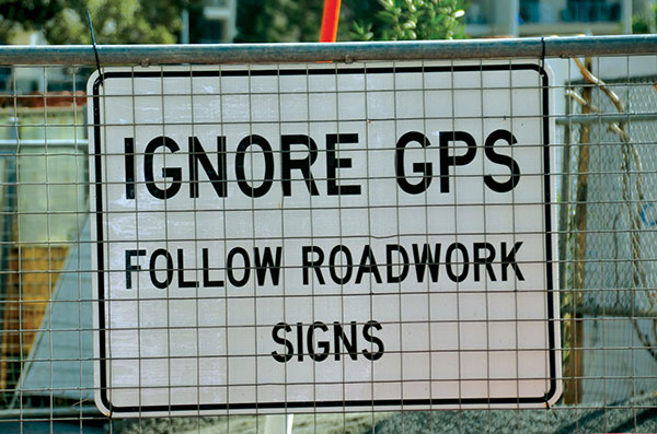
“What really annoys me is the misinformed assumption that SatNav and GNSS are one and the same. There is now a proliferation of ‘Do Not Follow SatNav’ signs [in the United Kingdom], and so many anecdotal stories about accidents caused by drivers blindly following SatNavs in their vehicles. These are almost always due to the deficiencies of the mapping and the route guidance components of the SatNav systems and not due to any problem with GNSS whatsoever. Nevertheless, it is GNSS that takes the blame.”
Terry Moore University of Nottingham
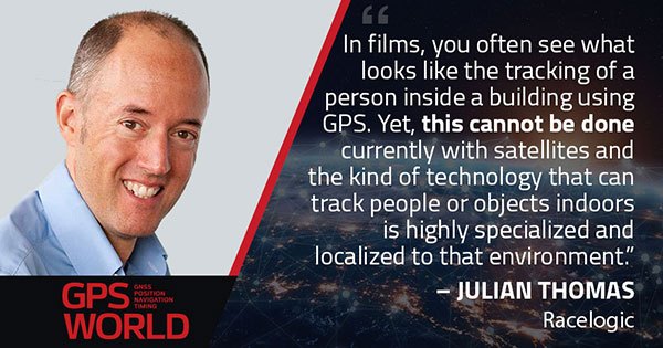
Julian Thomas Managing Director
“In films, you often see what looks like the tracking of a person inside a building using GPS. Yet, this cannot be done currently with satellites and the kind of technology that can track people or objects indoors is highly specialized and localized to that environment.”
Julian Thomas Racelogic Ltd.
Stuart Riley, vice president of GNSS technology, Trimble
“My pet peeve is the oversimplification of consumer navigation issues. I ran a few searches for ‘GPS fails’ and almost immediately saw images of cars in water and stuck in narrow streets. All too often, this is attributed to a GPS issue or failure. From a consumer perspective, the overall system from maps to satellites is considered GPS. The reality is that GPS (the satellites and control segment) is extremely reliable. Historically, satellite issues have been minimal. The most likely navigation errors are routing errors and old or erroneous maps, coupled with users blindly following the directions, and, to a lesser extent, receiver design issues (e.g., lack of ICD compliance) and harsh conditions (deep urban canyons).”
Stuart Riley Trimble
Mitch Narins
“For many, GPS/GNSS remains the miracle cure for all that ails you — for position/surveillance (e.g., ADS-B), for navigation (RNAV and RNP), and for the largest user base, time and frequency. Even while acknowledging the risks, many still treat GPS/GNSS interference as the 500-year flood that will ‘never’ happen in their lifetimes and, if it does, can be excused away as force majeure. It seems that in most of the articles I read it is always a sunny day and GPS/GNSS works perfectly. The need to incorporate resiliency is never emphasized. Nobody would buy a car without a spare tire. Isn’t it time for GPS/GNSS users to recognize the need and insist that an appropriate PNT ‘spare’ be included in the deal?”
Mitch Narins Consultant
Headshot: F. Michael Swiek
“We can chuckle while watching spies, super sleuths, and adventurers receive GPS positions in incredibly challenged environments — even in caves. My main beef is that nowhere is any mention made of who operates GPS. Instead, GPS is treated as an assumed given, embedded in a smart device, constantly and reliably available on demand anywhere and under all conditions. It is about time recognition and credit is given to those who actually make the miracle of GPS happen.”
Photo: Philipp Berezhnoy/iStock / Getty Images Plus/Getty Images
According to a new research report, “GNSS Simulators Market by Component Type (Single Channel and Multichannel), GNSS Receiver (GPS, Galileo, GLONASS and BeiDou), Application (Vehicle Assistance Systems, Location-based Services and Mapping), Vertical, and Region — Global Forecast to 2025,” the market is estimated to grow from $106 million in 2020 to $165 million by 2025, at a compound annual growth rate (CAGR) of 9.3% during the forecast period.
Factors such as rapid penetration of consumer internet of things, the contribution of 5G in enabling ubiquitous connectivity and increasing use of wearable devices utilizing location information are expected to drive the adoption of the GNSS simulators hardware, software and services, the MarketsandMarkets report said.
Market segments
The report stressed several key points in regard to the hardware segment, automotive vertical segment and GPS segment.
The GNSS simulators market, by component, is segmented into hardware, software and services. Of these three, the hardware segment is expected to account for a larger market size in the coming years in the GNSS simulators market as it enables signal simulations and plays a key role in the simulation process.
The GNSS simulators market, by vertical, is segmented into military and defense, automotive, consumer electronics, aerospace, marine and other verticals (agriculture, construction, and rail and road). According to the report, the automotive vertical segment is expected to hold a higher CAGR during the forecast period in the GNSS simulators market.
“GNSS offers a cost-effective and accurate way of determining position in real-time,” the report said. “Ride-sharing apps, such as Uber and Lyft, car-sharing, usage-based insurance apps, dynamic toll charging and parking apps all depend on the real-time location of the car. GNSS offers sufficient accuracy for all these apps by providing location coordinates leading to its adoption in the automotive vertical.”
Next, GNSS receivers are segmented into GPS, GLONASS, Galileo, BeiDou and others, with the others comprised of NavIC and QZSS receivers. The satellite tracking service provided by GPS is useful in various commercial and personal applications. The increasing commercial application of GPS vehicle tracking system for taxi companies and cab services is contributing to the rising adoption of GPS location services. It makes the navigation easier by providing relevant details, such as distance and shortest route to the desired location, the report said.
Market size and location
North America is expected to have the largest market size during the forecast period, with the key factor favoring the growth of the GNSS simulators market in North America being the increase in technological advancements coupled with the rise in government support for the adoption of UAVs. The increasing number of players across different regions is also further expected to drive the GNSS simulators market globally, the report said.
In addition, Asia-Pacific is projected to grow at the highest CAGR during the forecast period, as it has witnessed considerable developments and adoption of solutions across the region. According to the report, Asia-Pacific has a large potential for GNSS and space-enabled applications, and it has a wide consumer base due to its booming economies accompanied by an increasing share of local R&D and technology innovations.
Major players
Major vendors in the global GNSS simulators market include Spirent Communications, Rohde & Schwarz, VIAVI Solutions, Hexagon, Keysight Technologies, u-blox, Orolia, Cast Navigation, Accord Software and System, IFEN, Racelogic, Syntony GNSS, Teleorbit, iP-Solutions, Pendulum Instruments, Saluki Technology, Shanghai Huace Navigation Technology, Averna, GMV NSL, Brandywine Communications, Jackson Labs Technologies, Hunan Shuangln Electronic Technology, Work Microwave, Qascom and M3 Systems.
According to a new market research report, “Anti-Jamming Market for GPS with COVID-19 Impact, by Receiver Type (Military and Government Grade and Commercial Transportation Grade), Technique (Nulling, Beam Steering and Civilian), End-User, Application and Geography — Global Forecast to 2025,” the anti-jamming market for GPS is valued at $4 billion in 2020 and is expected to reach $5.9 billion by 2025.
The report, published by MarketsandMarkets, also states that the market is expected to grow at a CAGR of 7.9% from 2020 to 2025. Some of the key factors driving this growth include high demand for GPS technology in military applications and ongoing developments to improve overall GPS structure. Factors such as the growing demand for unmanned airborne vehicles and systems and the development of low-cost GPS anti-jamming solutions also are expected to provide growth opportunities to players in the GPS anti-jamming market.
According to the report, Nulling Technique is expected to hold largest share of GPS anti-jamming market from 2020 to 2025. In addition, surveillance and reconnaissance are expected to hold largest share of GPS anti-jamming market during the forecast period.
The GPS anti-jamming market in Asia Pacific is expected to grow significantly, as a result of a rise in the number of terror attacks in the region, which has led to countries enhancing their surveillance and antiterrorism capabilities, the report added. Countries in this area are also manufacture defense aircraft, which is expected to increase the scope of GPS anti-jamming for defense and aerospace systems. An increase in the defense expenditures of India and China, among other countries, and the expansion of militaries in emerging economies also have accelerated the demand for GPS anti-jamming solutions in Asia Pacific.
Raytheon Technologies, Hexagon, Thales Group, L3Harris Technologies, BAE Systems, Cobham, Mayflower Communications, infinDome, Lockheed Martin, Israel Aerospace Industries, Furuno Electric and Meteksan Defense are few major players in the GPS anti-jamming market.
MarketsandMarkets provides B2B research on 30,000 niche opportunities/threats that will impact 70% to 80% of worldwide companies’ revenues, the research firm said.