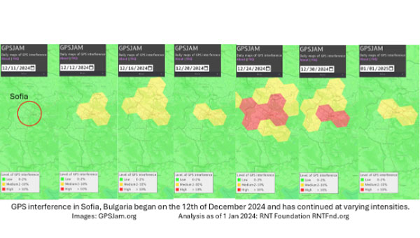
On Dec. 12, 2024, the European Union decided to include Bulgaria and Romania in the Schengen visa-free zone. On the same day, Bulgaria’s capital, Sofia, began experiencing interference with GPS signals. The interference, as reflected in aviation ADS-B systems and reported on GPSJam.org, continued through the new year and is ongoing as of this writing.
While these two events may be entirely unrelated, Vladimir Putin has a history of using GPS jamming and spoofing to show his displeasure with his neighbors growing closer to the West.
On Dec. 15, 2023, Poland activated a U.S. Aegis anti-missile system near its border with Kaliningrad, Russia. On the same day, Russia began jamming and spoofing GPS signals in northern Poland and parts of the Baltic. That interference persists to this day.
The interference in Sofia may be contributing to a prolonged Bulgarian political crisis. Politicians there have been struggling to form a new government since elections in October. Dec. 10 saw the beginning of a new attempt. Interference with GPS can undermine overall confidence in government systems and institutions — another of Putin’s goals for neighbors with whom he is displeased.
Another, though less likely, impact may be on Bulgaria’s electrical service. On Dec. 25, 2024, 20,000 households in western Bulgaria (Sofia is in the far west) lost electrical power and the outage continued for days. Many grid operators use GPS timing to help manage their systems. While press reports put the outages down to heavy snow and fallen trees, increased difficulty managing the grid might also be a factor.
Bulgaria’s GPS interference appears to be coming from somewhere in Sofia, not from Russian territory, as is the case in the Baltic. Yet Russia may still be involved, at least in a supporting role.
China’s BeiDou GNSS is newer, has more features, is more accurate, and has more satellites in the skies of more nations than the venerable U.S. GPS, according to Sarah Sewall, Executive Vice President for Strategic Issues at IQT.
Image: BeiDou program
More than that, it is one example of “a new form of great power competition that most in the U.S. government don’t recognize,” she said. China is providing superior precision, navigation, and timing information to enhance its diplomatic, economic and military power and the United States cannot afford to cede this area of longstanding advantage.
In a recent paper published by Harvard’s Belfer Center for Science and International Affairs, “China’s BeiDou: New Dimensions of Great Power Competition,” Sewall and co-authors Tyler Vandenburg and Kaj Malden outline their finding that China’s version of GPS is part of a longstanding effort to join the technological ranks of leading nations and leverage its capabilities to achieve geopolitical advantage in many areas.
“First, the global reach of BeiDou ensures that the Peoples’ Liberation Army is no longer dependent on another nation’s satnav. China’s economy — and those of other nations relying on BeiDou — can continue to function even if GPS is degraded or denied,” Sewall stated. “This may increase Beijing’s incentives to attack other national satellite capabilities.”
“BeiDou is also an economic driver for the Chinese economy and innovation. The output of China’s commercial space and navigation services industry has increased by tens of billions in the last decade, and new applications such as precision agriculture and self-driving cars show no sign of slowing,” Sewall continued.
The focus of Sewall’s paper, though, is the way BeiDou supports China’s Belt and Road and Digital Silk Road initiatives to gain influence and leverage around the world. She points out that in cases where BeiDou provides the most accurate positioning, navigation, and timing (PNT) data, particularly in the global south, China may be able to hold much of another nation’s economy hostage.
The BeiDou constellation has more satellites than GPS or any other system. It also has more than ten times the monitoring stations in other countries than have been deployed for GPS. As a result, in many places, particularly in the developing world, BeiDou’s accuracy is much better.
Her assessment of BeiDou’s technical superiority received some unexpected support recently from a government advisory board on GPS. It reported that “GPS’s capabilities are now substantially inferior to those of China’s BeiDou,” and urged the administration to regain U.S. leadership in the field.
Being newer and more advanced makes it easier for China to encourage other nations to use BeiDou signals and purchase specialized equipment, especially when equipment purchases are heavily subsidized by the Chinese government.
This is important because systems such as GPS and BeiDou provide more than just directions to the nearest coffee shop. Their precise PNT signals are used for everything from synchronizing cellphone networks and industrial machine controls, to time stamping financial transactions, and coordinating electrical grids. GPS has been called “the silent utility” because signals are used in almost every technology.
“It is very difficult for government leaders in the developing world to turn down discounted infrastructure and opportunities for economic development,” Sewall said. “Even if they know that tying that infrastructure to Chinese signals may give the CCP [Chinese Communist Party] a future on/off switch to their economies.”
The West and the United States in particular, faces challenges confronting China’s efforts with BeiDou, according to Sewall.
“Many in government equate national power with military power, but that’s a narrow and insufficient formulation, particularly in the 21st century,” Sewall said. “American officials under appreciate China’s efforts to create commercial technology dependencies abroad. The United States has left a vacuum in the developing world that our industry is seemingly unable to fill in the face of competition from Chinese firms that are heavily supported by their government.”
Sewall describes a Chinese “tech stack” being exported that include BeiDou services as part of Belt and Road and Digital Silk Road. It is comprised of a hierarchy of equipment that includes network cables, servers, and cell phones.
“We don’t really have a democratic approach to help foreign nations make meaningful technology choices. We risk ceding global infrastructure to China if we fail to help Western firms offer their own integrated products and services to the developing world,” she said.
If we recognized this new form of great power competition, America could easily leap frog China in areas such as satellite navigation, said Patrick Diamond, a member of the President’s Advisory Board on GPS.
“We could provide higher accuracy GPS and make signals much more secure though internet delivered authentication,” Diamond said. “We could offer complementary terrestrial systems to GPS that would give other nations their own sovereign source of precise time and location while at the same time cooperating with our signals from space.”
“Competing effectively with China in the coming decades will require Americans to think more holistically,” Sewall said, “from realizing that GPS is not just about the military and space, to understanding that national power is more than the ability to prosecute war.”
“Seen & Heard” is a monthly feature of GPS World magazine, traveling the world to capture interesting and unusual news stories involving the GNSS/PNT industry.
Image: Dennis Laughlin/iStock/Getty Images Plus/Getty Images
GNSS records Alaska earthquake data
Researchers in Alaska were able to compare the quality of GNSS and seismic station data when assessing the magnitude 8.2 Chignik earthquake near Dillingham, Alaska. Research recorded by Revathy Parameswaran and colleagues at the University of Alaska, Fairbanks, shows that GNSS and acceleration seismic data can be used interchangeably or in tandem to estimate rapid magnitude or ground motion. The research showed the Chignik earthquake velocity records were almost identical at co-located GNSS and seismic stations for observations at frequencies of less than 0.25 Hz.
No more high-speed chases
Image: Screenshot from CBS New York video
The Old Westbury Police Department of Long Island, New York, has chosen a high-speed pursuit alternative — GPS-equipped darts that relay the current location of suspects, reported CBS New York. It took $36,000 to equip six patrol cars with the air-powered dart launcher, called StarChase, which can be activated from inside the patrol car. When the launcher is activated, it shoots onto the suspect’s vehicle a dart with a GPS receiver inside and an adhesive exterior. It is considered a safe alternative to high-speed chases and safe to use around pedestrians.
Shou Zi Chew, CEO of the popular app TikTok, testified before Congress that TikTok does not collect precise location data from its users. During the hearing, which lasted for more than five hours, Chew assured committee members the app does not collect nor distribute location data. TikTok is under fire as a bipartisan Senate proposal is aimed at banning the social media app, arguing it poses cybersecurity risks. The House Committee interrogated Chew regarding the app’s algorithmic feed, policies for young users and — given TikTok’s Chinese ownership — the amount of access the Chinese government has to user data.
Just some water, please
Image: Bob Douglas/iStock/Getty Images Plus/Getty Images
Satellite mapping data analyzed at Graz University of Technology’s Institute of Geodesy has revealed long-term drought conditions in Europe, reported GIM International. The data confirmed groundwater levels have been low consistently since 2018. The drought situation was originally published by Eva Boergens in “Geophysical Research Letters” in 2020 when she noted there was a severe water shortage in Central Europe during the summers of 2018 and 2019. There has been no significant rise in groundwater levels since then, and groundwater levels have stayed constantly low.
The United Kingdom’s spectrum agency, Ofcom, is seeking comments on its proposal to issue licenses for broadcasting eLoran signals and services. This initiative comes, it says, after the agency was “…approached with a request to authorize use of the 90-110 kHz spectrum for the provision of a long-range navigation system, based on eLoran technology.” Issuing licenses could be a way to treat all interested parties fairly.
After briefly describing the importance of positioning, navigation, and timing (PNT) services to modern life, the Ofcom request for comment observes: “Satellite-based PNT systems like the Global Positioning System (GPS) can be susceptible to interference and can be vulnerable to space weather events. The eLoran technology provides a terrestrial-based alternative … which could in [the] future act as a supplementary or back-up system to GPS. [I]t has the potential to support innovation in the delivery of resilient PNT.”
This rationale is quite similar to that cited by other governments operating Loran-like systems around the world.
Until now, with a few minor exceptions, only government entities and those working on their behalf have been authorized to use the frequency. Such licenses would authorize holders to broadcast eLoran in the 90 kHz to 110 kHz band, which is the portion of spectrum reserved internationally for radio navigation.
From October 2014 to December 2015, the UK had an operational eLoran network serving the waters off its east coast and authorized for maritime use. That system was discontinued when France and Norway bowed to pressure from supporters of Europe’s Galileo system, which was still in development. The UK Ministry of Defence still broadcasts a single eLoran signal from Anthorn, UK, that can be used as a wireless timing source.
Several other nations currently broadcast some version of Loran in the 90 kHz to 110 kHz band. These include PNT systems operated by South Korea, Saudi Arabia, Russia and China. Reports indicate Iran is also broadcasting in the spectrum, though other details remain unclear.
Unconfirmed reports from amateur radio operators in the United States seem to indicate that testing of Loran-like signals in the 90 kHz to 11 0kHz band has been conducted in North America periodically over the last 10 years.
Until now, the UK has only formally authorized eLoran and the frequency for maritime use. Observers in the UK say this Ofcom initiative will almost certainly expand that to its use everywhere and for multiple applications, such as timing for critical infrastructure.
Ofcom says, “[d]eployment of eLoran in the UK could complement existing PNT services, particularly in locations where there is poor GPS coverage or weak signals, like tunnels or deep inside buildings. eLoran could also provide resilience (i.e., back-up) for satellite-based systems against interference, jamming and spoofing, thereby aiding protection of key national infrastructure…”
This Ofcom notice may be the first official move toward encouraging one or more entirely commercial eLoran services.
Commercial wide-area PNT services capable of protecting critical infrastructure and national economies have long faced an uphill battle, though.
Several industry leaders have commented that “it’s impossible to compete with free GNSS!”
The same leaders have also criticized the U.S. government for not “walking the talk” when it comes to resilient PNT. At a U.S. Department of Transportation meeting last year they urged the government to not just tell others, but to set an example and protect itself with resilient PNT services. Doing so, they said, would show industry and users the government is serious and instill confidence that commercial services were reliable and would be sustained.
Yet, experts cite a “chicken and egg” problem.
“The government can’t subscribe to services that don’t exist, and companies can’t stand up and provide nation-wide services without having an anchor-customer first,” according to an industry insider.
To solve this dilemma, public-private-partnerships have been proposed over the years in both the UK and the United States. To date, a willing “public” or government partner has yet to be identified for either nation.
This might be changing in the UK government with growing awareness about the limitations of and threats to GNSS and other space systems. While a national strategy for PNT has been promised for years and is yet to be published, a cross-government PNT office has recently been established.
“The UK is in a great position to lead the world on resilient PNT,” said one observer at a recent Royal Institute of Navigation event. “The key is working with GPS and other GNSS, while at the same time ensuring your nation has its own sovereign system independent of space. We (in the UK) have deep expertise and experience at the GLA (General Lighthouse Authority) with eLoran, and we have a superb tech economy. Britain could be the world’s leading producer of a resilient PNT tech stack that includes eLoran transmitters, receivers that use GNSS, eLoran, and other signals or phenomena, and all the supporting gear and IP (intellectual property) to make it all work.”
“Realizing that vision will take a bit more government leadership than just issuing a few broadcast licenses, though,” they said.
An official evaluation of Advanced RAIM (ARAIM), a GPS technique used in aviation receivers for safer landings and take-offs, is being conducted by the William J. Hughes Technical Center (WJHTC) of the U.S. Federal Aviation Administration (FAA).
The WAAS Test Team at the technical center has begun to monitor the Integrity Support Data (ISD) parameters of ARAIM using evaluation tools and methods developed by both the center and Stanford University. Results of this monitoring will be published in a quarterly report on the WAAS Test Team website.
The Need for Advanced RAIM
ARAIM addresses various weaknesses of Receiver Autonomous Integrity Monitoring (RAIM).
To assure the integrity of GPS, aviation receivers implement RAIM, which detects any GPS satellite fault, and can then isolate and remove it from the navigation solution.
However, RAIM provides integrity only for horizontal operations, such as enroute and non-precision approach. Additional integrity is needed to allow advanced capabilities, such as vertically guided approaches. Other integrity systems, including the Wide Area Augmentation System (WAAS), provide the integrity needed to permit these additional operations.
Since RAIM’s debut, GPS and other GNSS have evolved to improve their performance and upgraded to add an additional civilian signal, making possible ARAIM architecture.
ARAIM increases the geometric diversity and integrity availability by using two core GNSS constellations (such as GPS and Galileo). ARAIM takes advantage of the second civilian signal by specifying dual-frequency processing so that the ionospheric error from GNSS signals is directly measured by the user equipment.
The ionosphere — in most cases, the largest source of error in a GNSS signal — can also reduce the integrity of GNSS signals. Data provided for ARAIM use can include improved performance commitments from the GNSS constellation. RAIM uses static values for those performance commitments.
Enabling LPV-200 Approaches
The dual-frequency multi-constellation ARAIM seeks to allow LPV-200 approaches worldwide. LPV-200 (localizer performance with vertical guidance) delivers accurate information on an aircraft’s approach to a runway with the use of GNSS positioning technology. The result is lateral and angular vertical guidance without the need for visual contact with the ground until an aircraft is 200 feet above the runway.
ARAIM is considered an aircraft-based augmentation system: the algorithm to determine GPS integrity is in the aircraft receiver, just like RAIM. ARAIM could use both GPS and Galileo to achieve the worldwide LPV-200 service goal, with the integrity needed available from satellites of both constellations.
Integrity Support Data. An important aspect of ARAIM is the integrity support message, which contains the ISD that describe a GNSS constellation’s accuracy and reliability. Each GNSS constellation service provider generates and updates its ISD data, while the receiver manages and uses each GNSS constellation message.
The specific ISD parameters for ARAIM have not yet been finalized, but candidate data includes the probabilities of satellite and constellation failure (for instance, more than two satellites fail due to a common cause), user range error, user range accuracy data, and other candidate data.
The ISD will be finalized when the International Civil Aviation Organization (ICAO) Standards and Recommended Practices (SARPs) with the ARAIM requirements are completed.
To ensure that the data provided in the ISM remains valid, external monitoring is needed. The external monitoring ensures the satellite and constellation failure probabilities provided in the ISM continue to be valid. External monitoring also characterizes the user range accuracy and user range error in the ISM.
Lockheed Martin has developed a satellite-based augmentation system (SBAS), which uses signals from the GPS and Galileo constellations, according to a report by Space News.
The second-generation SBAS uses both GPS L1 and L5 and Galileo E1 and E5 signals to provide accurate navigation and positioning and to reduce dependence on just one system. The SBAS broadcasts on two frequencies to augment the signals from both GPS and Galileo.
Image: EUSPA
In September 2022, Lockheed Martin won a $1.18 billion 19-year contract to develop and operate the Southern Positioning Augmentation System Network (SouthPAN) for Australia and New Zealand. The company is also having discussions with other potential international customers.
As a part SouthPAN, the dual-frequency multiple constellation SBAS signal is being broadcast. As more GPS III and GPS IIIF satellites are launched, including one Jan. 18, service will continue to improve.
On Jan. 5, FocalPoint announced an investment from GM Ventures, and collaboration with General Motors (GM), on the integration of next-generation GPS technology in the automotive industry. This collaboration will explore the deployment of electric and autonomous vehicles and aims to apply FocalPoint’s technologies into future vehicles produced by GM to make navigation more precise, especially in urban environments.
Image: FocalPoint
FocalPoint’s Supercorrelation is designed to increase positioning accuracy in urban environments and is highly resilient to spoofing attacks. It will be integrated into GM vehicles to provide more accurate navigation. The goal of the integration is to enhance and expand GM’s Super Cruise, and upcoming Ultra Cruise, hands-free, driving assistance technology.
Supercorrelation is already licensed to u-blox and is in advanced trials with other major manufacturers including Molten Ventures, Greshham House, Passion Capital, IQ Capital, Cambridge Angels and more.
Sentinel-3 A&B CPOD Precise Platform data (AUX_PRCPTF)
The following new products from Sentinel-3 and Sentinel-6 are now available as well. The Sentinel-6A GNSS RINEX observations include GPS and Galileo data — the first publicly available Galileo data obtained from an orbiting receiver.
Sentinel-3A&B CNES Medium Orbit Ephemeris (SR___MDO_AX)
The GNSS RINEX (AUX_GNSSRD) and Quaternions files (AUX_PROQUA), together with the final orbital products (AUX_POEORB, AUX_PRCPTF, SR___POE_AX, and AX____POE__AX) are available at the beginning of each mission.
The other orbital products (AUX_RESORB, SR___ROE_AX, SR___MDO_AX, AX____MOED_AX, and AX____ROE__AX) are available for at least one month, until the final products are available.
The typical accuracy of the orbital products can be found in the Regular Service Reviews carried out by the CPOD Service quarterly.
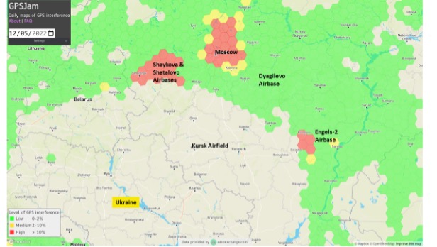
Two Russian airbases deep inside the country were attacked on December 5: the Engels-2 base in the Saratov region and Dyagilevo near Ryazan. The next day an oil tank at the Kursk airfield closer to the border with Ukraine was hit and set on fire.
The Russian government has long interfered with reception of GPS signals, especially near and within its own borders. The early December attacks seem to have motivated an increase in this activity.
More Interference
Information displayed by the website GPSJam.org indicates that, on the first day of the attacks, GPS interference was detected around Moscow, at two airbases to the east, and near the Engels-2 airbase.
Image: RNT Foundation
GPSJam.org uses anomalies in crowdsourced aviation ADS-B data as an indicator of unreliable GPS signals. Note that no such information is available for much of Ukraine as commercial aircraft have been avoiding the airspace since the beginning of the current conflict.
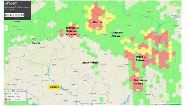
The GPSJam.org depiction of the region six days after the attacks is quite different and has stayed much the same ever since. It seems to show greatly increased interference in the vicinity of the Engles-2 airbase, and new interference around the Marinikova airbase to the south along the Volga River.
Image: GPSJam.org
A History of Jamming and Spoofing
The Russian government has been deliberately and systematically interfering with GPS signals in some places since at least 2016.
The article documented a tech podcaster’s discovery that GPS L2 and L5 signals were being jammed and GPS L1 was being spoofed in the vicinity of the Kremlin. The combination of jamming and spoofing caused receivers in the area to report that, rather than being downtown, they were at the Vnukovo international airport some 20 kilometers away.
The author of the article speculated the spoofing was to protect government officials and buildings from surveillance and attack by UAVs. Since 2013 most larger UAVs have been programmed by manufacturers with the locations of airports and to avoid them. Making UAVs near the Kremlin believe they were at an airport could be an effective part of an overall defense system by causing them to avoid the area.
In 2017 the Resilient Navigation and Timing Foundation examined maritime AIS data and found similar spoofing activity had been occurring in the Black Sea for at least two years. A 2019 report by the nonprofit C4ADS expanded upon this work and revealed spoofing activity at various times and places across Russia. Almost 10,000 instances were documented across ten locations between 2016 and 2018. The report also linked much of the spoofing to the Russian Federal Protective Service and movements of senior government officials. This reinforced the idea that the spoofing was part of VIP protection efforts.
Questions Abound
It is easy to conclude that Russia’s recent increases in interference activity were in reaction to the UAV attacks on December 5 and 6.
Western intelligence and military officials may be arriving at additional conclusions and asking themselves some intriguing questions. One might be why it took six days after the first UAV attack to implement the new interference scheme. The report by C4ADS made it clear that Russian equipment used for wide area spoofing is quite portable.
Perhaps the delay was one of decision making. Some observers have commented that much of the direction for the current conflict comes directly from the top, rather than being delegated to field commanders. It could well be that it took that long for the Kremlin to realize that UAVs were involved and direct equipment to be deployed.
Another question likely being asked is about the selection of locations where interference is being used. Interference activity was observed at the Engels-2 airbase before it was attacked. This seems to have greatly increased after the attack. Airfields at Dyagilevo and Kursk were also attacked, but no interference activity has been observed at either location.
At the same time, substantial new interference activity has been observed at the Marinikova airbase, which was not attacked. There are likely several contributing factors to why some locations have been protected with jamming and/or spoofing and some not.
While Russian forces have a fearsome reputation for electronic warfare and their ability to interfere with GPS signals, the amount of equipment and the number of trained operators may be limited. C4ADS’ finding that spoofing equipment was moved around with VIPs rather than permanently located around the nation could indicate a limited amount.
This would mean that the bases and facilities to be protected must be prioritized. The lack of interference around Kursk and Dyagilevo could mean Russia sees them as less important, or less likely to be attacked again. New interference at Marinikova could mean it is a high value target and in need of protection.
Conversely, some of the new activity could be designed to deceive and draw Ukrainian fire away from higher value targets and toward lower ones. Such is the potential nature of military strategy in war.
Analysts are also probably asking questions about the effectiveness of jamming and spoofing as a defense against a determined UAV-operating opponent.
Interference had been detected at Engels-2 before it was successfully attacked by one or more UAVs. This likely shows that Ukrainian forces disabled any geofencing that might have been originally included as part of the UAVs’ original design. They may have also upgraded the UAVs’ navigation receivers with hardware or software to make them much more resistant to interference from the ground.
Navigation Warfare Increasingly Important
Regardless, the UAV attacks and observed changes in interference activity reaffirm the importance of navigation warfare in modern conflicts. Knowing the location of your forces and of your targets has always been important. In an era of precision strike and autonomous systems, robust and resilient navigation that resists or overcomes interference is even more important.
The U.S. military has long recognized this, establishing its Joint Navigation Warfare Center in 2004. The center focuses on the intersection of positioning, navigation, and timing with electronic warfare and cyber operations. Undoubtedly Russia has identical concerns and probably an equivalent organization.
The current conflict in Ukraine will continue to raise questions for both sides. Not in question, though, is the importance of navigation warfare to this conflict, and that it will be increasingly important in future ones.
By all accounts, it is getting worse. Hundreds of internet sites sell inexpensive devices to interfere with GPS and other GNSS signals. Estimates place the number of devices extant in the United States in the tens of thousands or more. Studies show accidental interference happens about ten times more often than deliberate jamming.
In January a high-power signal in the Denver area impacted GPS reception across 4,000 square miles of airspace. The source was located, and the signal terminated after 33 hours.
October saw a similar event near Dallas that lasted for 44 hours before it ended on its own. The source of that signal was never identified.
The United States spends more than $2 billion a year to operate, maintain, and refresh GPS. Its positioning, navigation, and timing (PNT) services underpin virtually every technology, every facet of the economy. Yet, as was dramatically demonstrated at least twice this year, the nation does not have the ability to quickly characterize, locate and mitigate even the most powerful jamming signals.
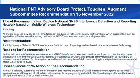
The group’s most recent recommendation is to implement a detection network based on crowdsourcing and smart phones. This would be done in collaboration with wireless service carriers.
Yet cooperation of wireless carriers, while helpful, may not be necessary, according to at least some experts.
Dr. Dennis Akos of the University of Colorado has developed an app for Android smart phones that enables devices to detect and automatically report interference with GPS and other GNSS signals. The app uses four detection methods based on location data already used by Android devices. These are comparing GNSS and network locations, checking the Android mock location flag, comparing the GNSS and Android system times, and observing the automatic gain control (AGC) and carrier-to-noise density (C/N0) signal metrics.
Commenting on Akos’ work, GNSS expert Logan Scott suggests that the U.S. government could use this new capability to establish the first phase of a national GPS/GNSS interference detection network with very little cost or effort.
“The US government provides managed phones to many government employees,” he said. “Having an app like Dennis’s operating on an opportunistic basis, [only when GPS is on in the phone] would give access to millions of phones as observers. Bottom line, the US could stand up a national observation network on an accelerated timeline, understand the nature of the threat, and avoid the embarrassments of [events such as those that occurred at] DIA [Denver International Airport] and DFW [Dallas Fort Worth airport]. And it would not cost much.”
If an effective system of some sort is not implemented, American lives and property will be at continued and increasing risk. In the words of the Advisory Board recommendation:
Dr. Dennis Akos. Image from University of Colorado’s website.
“Without a reliable, automated means of detecting and locating sources of GNSS interference, space-based PNT applications, and the general U.S. public, will continue to be plagued by potentially life-threatening and/or costly service disruptions that take days or weeks to resolve.”
Spirent plans to host two seminars in early 2023 where experts will share PNT developments and provide training on Spirent’s products. Registration for the seminars is free and includes a two-week software license that can be downloaded to provide hands-on training.
Seminar training topics includes fundamentals of GPS/GNSS testing, how to create realistic testing scenarios, GPS/GNSS vulnerabilities like jamming and spoofing, vulnerability mitigation and more.
One session will be held in Huntsville, Alabama, March 8-9 and the other in Los Angeles, California, March 14-15. While registration is free, seats at both seminars are limited.
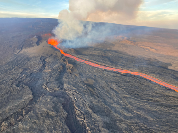
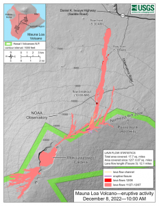
In late November, the Mauna Loa volcano in Hawaii erupted for the first time since 1984 and is currently in an active volcanic eruption. Scientists are using satellites and helicopters to record and map the flow of lava on the Big Island.
The active eruption is in a remote area on the island, making it difficult to map it and the lava flow. It is critical to have accurate emergency information during the eruption in order to have appropriate resources and have ample time to evacuate, if necessary.
The easiest and most accurate way to map the lava from this eruption is via satellite. Based on satellite observation, scientists have been able to create a mobile app to support helicopter crews in making maps of lava flow that update in real time. This real time evaluation is sent to emergency personnel and geologists tracking the eruption patterns.
Image: USGS
Mauna Loa has erupted 33 times, the most recent of which was 38 years ago. The volcano typically averages an eruption every 5 years, making Mauna Loa’s most recent dormant period longer than normal. According to the U.S. Geological Survey (USGS), this eruption was caused by an increase in earthquakes below the Mauna Loa Summit, an increase of inflation tracked by GPS stations, and several additional geologic factors.
Live footage of the Mauna Loa eruption can be seen here.


