Raytheon’s F-35 precision landing system can be set up anywhere in less than 1.5 hours
A Raytheon Company team has conducted a rapid set-up demonstration of a land-based expeditionary version of its Joint Precision Approach and Landing System (JPALS) to a group of global military officials at Naval Air Station Patuxent River, Maryland.
JPALS is a GPS-based precision landing system that guides aircraft to precision landings in all weather and surfaces conditions.
“The entire system was fully operational in 70 minutes on Day One and 50 minutes on Day Two,” said Matt Gilligan, vice president at Raytheon’s Intelligence, Information and Services business. “Raytheon is offering the U.S. and its allies fast and accurate precision landing systems that support operations from bare-base locations.”
During the demonstration, military officials from all four services, as well as representatives from Japan, United Kingdom, The Netherlands and Italy, watched multiple F-35Cs land on the same designated runway landing point every time over the course of six different approaches.
This was the second proof-of-concept event in 2019 showing how F-35s can use a reconfigured mobile version of JPALS to support landings in austere environments.
JPALS is a differential, GPS-based precision landing system that guides aircraft onto carriers and amphibious assault ships in all weather and surface conditions up to the rough waters of Sea State 5. It uses an encrypted, jam-proof data link to connect to software and receiver hardware on the aircraft and an array of GPS sensors, mast-mounted antennas and shipboard equipment.
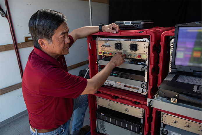
A Raytheon technician operates the rapidly installed JPALS equipment during a demonstration at the Naval Air Station. (Photo: Raytheon)
The GPS World staff reported live from Intergeo Sept. 17-19 in Stuttgart, Germany. The massive trade show, dubbed the “global hub of the geospatial community,” brings together more than 19,000 visitors from more than 114 countries and features approximately 640 exhibitors. Check out the latest industry news, as well as photos and videos from the event.
A sonar survey, camera and sensor data of the world’s largest marine sinkhole is shining light on sea level and climate change over 100,000 years.
From Nov. 27 to Dec. 13, 2018, the Blue Hole Belize Expedition mapped the sinkhole. Led by Aquatica Submarines, the team of scientists, explorers and film makers included Virgin ’s Sir Richard Branson and Fabien Cousteau, grandson of the conservationist Jacques Cousteau.
Kongsberg used both surface and submarine-mounted sonar equipment.
Sonar expert Mark Atherton from Kongsberg’s Canadian subsidiary Kongsberg Mesotech was a key member of the science-based sonar and scientific data collection team. Atherton operated the sonars aboard the Research Vessel Brooks McCall, contributing to an invaluable high-resolution map of the entire sinkhole.
“By understanding the geological history and geometric structure at the Blue Hole we can contribute new data to the global scientific community studying sinkholes and cenotes,” he said.
Photo: Aquatica Submarines
Aquatica Submarine’s Stingray 500 submarine was used for sonar surveying, filming and dives. The team conducted more than 20 dives into the large sinkhole, taking videos and 3D images during each trip. They also completed a two-hour live broadcast featured on The Discovery Channel.
A key outcome of the Expedition is creation of a complete 3D sonar map of the Blue Hole. The sonar map is enhanced with other passive submarine-collected environmental data. Once processed and collated, the data will be shared with the Government of Belize and the larger global scientific community as a legacy from the expedition.
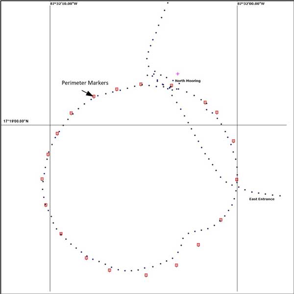
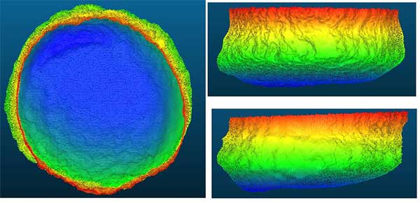
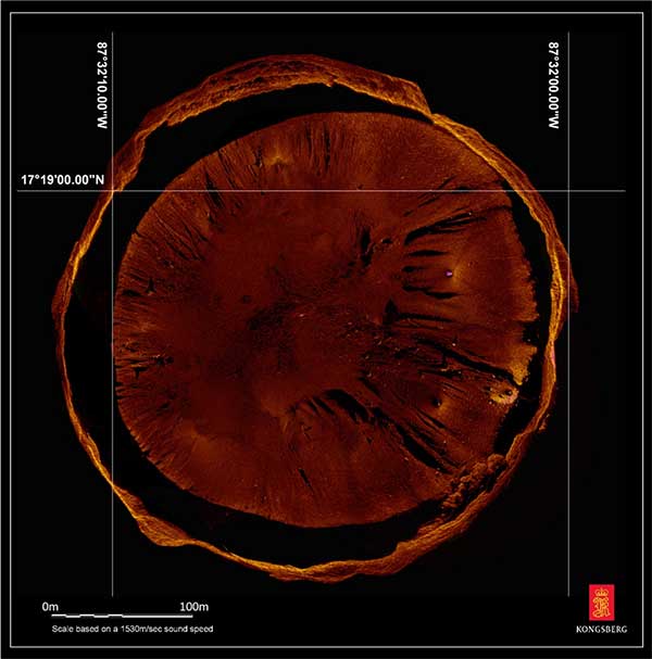
Perimeter Markers: Using an SBG Systems Ellipse receiver positioned directly over suspended tripods, positions were locked in the MS1000 processing software the instant each tripod touched bottom. With no current within the Blue Hole and the tripod and sonar weighing 21.7 kg, there was no issue with offset position differences between the vessel and the tripod hanging plumb during deployment. (Image: Mark Atherton/Kongsburg)Processed Scan Data: A dual-axis sonar (DAS) system collected point-cloud data to create a 3D representation of the Blue Hole. The unit was pole-mounted on the survey vessel with the GPS and motion reference unit directly over the scanner’s head. (Image: Mark Atherton/Kongsburg)Mosaic: GPS tripod position and target matching on overlapping scans were used to align the 50-, 75- and 100-meter-range data collected at 21 drop locations. This mosaic is a very close approximation of the bottom of the Blue Hole. (Image: Mark Atherton/Kongsburg)
The last two U.S. presidential administrations failed to follow through on promises to protect GPS and the nation with a system to backup GPS. A recent Department of Transportation (DOT) appointee is aiming to fix that.
Diana Furchtgott-Roth is deputy assistant secretary of Transportation for Research and Technology. Her office has a broad range of responsibilities including as the federal government lead for civil GPS and PNT issues.
Since Furchtgott-Roth arrived at the department in February, she has been adamant about the need to establish a complementary and backup system that users can access when GPS is not available or signals need reinforcing. She notes that this has been a presidential policy requirement for DOT since 2004.
There are also two Congressional mandates on this issue. The first mandate was in a law passed in 2017. The National Defense Authorization Act tasked the Departments of Defense, Transportation, and Homeland Security to jointly conduct a technology demonstration of GPS backup technology.
Congress funded this project in 2018 through the Defense department, even though DOT was the lead agency. Bureaucratic delays in transferring the funds between departments has meant that, rather than concluding in the summer of 2019 as initially required, the demo is behind schedule by about eight months.
Much of this transpired before Furchtgott-Roth arrived on scene and she is determined to make up for lost time.
A Request for Information (RFI) seeking candidate GPS backup technologies was issued in early May of this year and closed 30 days later. Twenty-two responses were received, though some just offered comments and observations rather than proposing technologies.
Working through the Volpe National Transportation Systems Center, Furchtgott-Roth’s goal is to demonstrate as many of the technologies as possible and conclude the effort by March of next year.
“We want to thoroughly understand all of the proposed technologies, including their ability to penetrate indoors and underground without assistance,” Furchtgott-Roth said.
The department’s procurement website forecasts a Request for Proposals for this effort this month (the site says it will be issued in the fourth quarter of the fiscal year which ends on Sept. 30). The opportunity is described as “Backup Global Positioning System (GPS) Technical Consulting Services for participation in a technology demonstration” with an estimated value of between $700,000 and $2,000,000.
Small businesses that want to be on the notification list for this can do so through the FedBizOpps announcement page.
The second legislative mandate was signed into law in December 2018. The National Timing Resilience and Security Act requires the Department of Transportation to establish a timing system to back up GPS by December 2020.
Among the requirements specified in the Act are that the system must be terrestrial, wireless, have wide area coverage, be difficult to disrupt, and be capable of expansion to provide positioning and navigation services.
Furchtgott-Roth plans to integrate the department’s responses to both taskings as much as possible. “What we learn from the tech demo should very much inform the implementation of the National Timing Resilience and Security Act,” she said.
She also wants everyone on the project to keep in mind that establishment of the timing system is just the first phase of creating a more robust and resilient national PNT architecture. “Timing is important, and we are going to reinforce it first,” she said. “But it is not going to provide resilient positioning and navigation for drones, autonomous vehicles, and all our other transportation needs. America must have a combination of systems available that, when used together, will be very difficult to disrupt.”
To keep things moving quickly, Furchtgott-Roth says she is leaning toward signals provided by a commercial entity, rather than a government-built system.
“The Act suggests we consider a public-private-partnership, and there are a lot of advantages to that,” she said. “The government wouldn’t need to stand up a big acquisition staff or have a large appropriation of funds from Congress. Also, private entities are often able to act faster and be more agile. And they assume most of the project risk.” The aviation safety ADS-B system was created using such a procurement model.
The only snag is that while Congress has appropriated money for the tech demo, it has not yet done so for the mandated operational system. Sources in Congress point out that although the House version of the 2020 budget has $32 million for Air Force “Resilient PNT,” nothing has been allocated for civilian users.
“$32 million would go a long way for DOT’s efforts to protect the 99.9% of GPS users who are not in DoD,” said one congressional staff member. He was hopeful the Senate would designate funds in its version of appropriations for DOT and the issue would be resolved positively in conference.
“GPS has become an invisible utility that so many of our technologies depend upon,” observed Karen Van Dyke, who leads PNT efforts for Furchtgott-Roth’s office. “Providing a complementary and/or backup capability ensures users have PNT even when GPS is disrupted. It may also help protect the signals themselves by deterring malicious actors who might otherwise want to jam or spoof GPS.”
“President Trump’s top priorities are national and economic security. We can’t have GPS signals be a single point of failure for transportation and other critical infrastructure sectors,” Furchtgott-Roth said.
Dana A. Goward is the president of the Resilient Navigation and Timing Foundation.
NavtechGPS is offering the following multi-day training sessions on GNSS/GPS technology in New Orleans this December. Both courses will take place at the InterContinental New Orleans Hotel.
Take this 4-day course to gain a comprehensive understanding of GPS/GNSS system concepts, design and operation, including information on GPS signal processing by the receiver; techniques by which GPS obtains position, velocity and time and a brief introduction to differential GPS (DGPS) and Kalman filtering.
Expanded to a full five full days based on attendee requests, this course on GPS-aided navigation will thoroughly immerse you in the fundamental concepts and practical implementations of the various types of Kalman filters that optimally fuse GPS receiver measurements with a strapdown inertial navigation solution. The course includes the fundamentals of inertial navigation, inertial instrument technologies, technology surveys and trends, integration architectures, practical Kalman filter design techniques, case studies, and illustrative demonstrations using MATLAB.
Five fulls days allow for a fuller and detailed development of the design of an aided navigation system, combined with a detailed discussion of the use of lower quality IMUs, and advanced filtering techniques.
The Galileo signal outage, ongoing since Thursday, July 11, has been attributed to a problem with the system’s ground infrastructure, according to an announcement by the European GNSS Agency (GSA). “Experts are working to restore the situation as soon as possible,” states the GSA. “An Anomaly Review Board has been immediately set up to analyze the exact root cause and to implement recovery actions.”
No update has appeared at this time as to when service will resume.
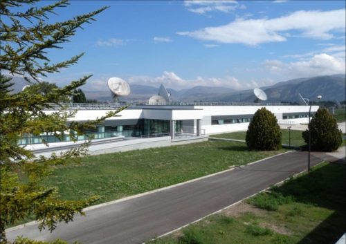
[Photo: Galileo’s Ground Mission Segment in the Fucino Control Centre in Italy oversees Galileo navigation services and satellite payload operations. Photo: Telespazio.]
The announcement points out that Galileo is currently in its initial services phase, wherein its signals are available for use in combination with other GNSS and do not provide a complete solution in and of themselves. This status is expressly designed to allow for “the detection of technical issues before the system becomes fully operational,” according to the GSA.
Indeed, experiments undertaken with Galileo-capable smartphones found that these devices excluded Galileo participation in their position solution. This is likely true of commercial receivers as well, which employ sophisticated signal checks as well as following system notice advisories, which have been issued in this case.
“For each constellation, there is a defined maximum age of ephemeris that is considered valid,” explained Sandy Kennedy, vice president, innovation at NovAtel. “Once an ephemeris is too old, our receiver will deem it invalid. Measurements made to satellites without a valid ephemeris are not allowed to contribute to the PVT solution. We noticed the missing Galileo ephemeris within 3 hours of the broadcast stopping. It wasn’t the NAGU that alerted us to the problem.”
The company posted a bulletin to its website on Friday afternoon, July 12, stating: “During this time [without ephemeris], NovAtel receivers will continue to track Galileo signals, but without a valid ephemeris, the signals are not included in the position solution. . . . Once the Galileo service returns to normal and transmits ephemeris information, NovAtel receivers will revert to normal operation.”
The experiments mentioned above were conducted by the Navigation Signal Analysis and Simulation (NavSAS) Group at Fondazione LINKS (formerly the Istituto Superiore Mario Boella) and the Politecnico di Torino. In their account they state that, using a software receiver that tracked the Galileo signals in space (SISs), “the position solution computed using both the GPS and Galileo constellation is affected by errors on the order of 500 meters or even more.”
In a detailed technical analysis, the NavSAS Group found three other curious and unexpected aspects of the situation, all explored and illustrated at the Group’s posting.
The National Aeronautic and Space Administration (NASA) is readying for an ultra-precise atomic clock that could not only transform the navigation of deep space missions, it could also improve the accuracy of GPS timing and thus GPS positioning. It is expected to launch in June.
Drawing of the DSAC mercury-ion trap showing the traps and the titanium vacuum tube that confine the ions. The quadrupole trap is where the hyper-fine transition is optically measured and the multipole trap is where the ions are “interrogated” by a microwave signal via a waveguide from the quartz oscillator. (Image: NASA.)
The Deep Space Atomic Clock (DSAC) is a very small (the size of a toaster) mercury-ion atomic clock that is as stable as a highly precise ground atomic clock, yet small enough to fly aboard a spacecraft, and rugged enough to operate in deep space. Current ground-based atomic clocks that locate and navigate deep space missions are too massive to fly in space themselves.
Thus, tracking data from the far-flung spacecraft must be collected and processed on Earth, meaning a two-way tracking link. DSAC will enable NASA to improve tracking data precision by an order of magnitude for its deep space missions out to Jupiter, Saturn — and beyond.
It could also be used to improve the accuracy of GPS. DSAC is more stable and accurate than the atomic clocks currently aboard GPS satellites. As system modernization proceeds, use of a DSAC aboard future satellites holds out many promises. DSAC technology uses the property of mercury ions’ hyperfine transition frequency at 40.50 GHz to steer the frequency output of a quartz oscillator to a near-constant value.
The clock confines the mercury ions with electric fields in a trap and protects them by applying magnetic fields and shielding. It is anticipated that DSAC would produce only 1 microsecond of error over 10 years.
For further details on NASA’s Deep Space Atomic Clock project and detailed callouts on the diagram above, look here.
Spirent Federal Systems, a provider of GPS/GNSS test equipment, announced that Col. (retired) Bernard Gruber, former program director of what is now the U.S. Air Force GPS Directorate, has joined the company’s board of directors as government security committee chairman. Also joining as the chairman of the board is Robert Lollini.
Spirent Federal President/CEO Ellen Hall stated, “We are happy to have retired Col. Gruber and Bob Lollini joining our dynamic company. We are leading the industry in innovation and quality products for the U.S. government and these two new leaders will help us continue that momentum.”
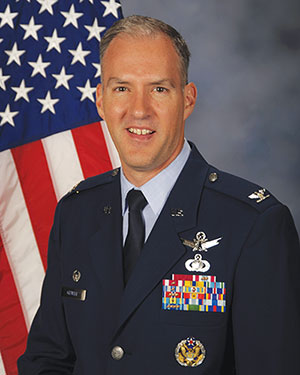
Col. Bernie Gruber in 2012. (Photo: U.S. Air Force)
Bernard Gruber brings to the position the experience gained from a long and distinguished career in the government and military sector. Mr. Gruber has held several positions in important commands focused on navigation in space, including serving as the chief of Space and Global Integrated Intelligence at the Pentagon from 2009-2010, and director of the Global Positioning System (GPS) at the Los Angeles Air Force Base from 2010-2013. He is currently the director of Precision Guidance and Advanced Programs, Armament Systems at Northrop Grumman.
Robert Lollini is currently the chief executive officer and president of BioFire Defense LLC, a subsidiary and proxy company of bioMerieux. Lollini contributes to the board his broad understanding of strategic financial and executive management.
Spirent Federal Systems was formed in July 2001 by Spirent Communications as a wholly owned subsidiary and U.S. proxy company. Spirent Federal markets and sells Spirent Communications’ GNSS products in North America. The company also provides value-added features and ongoing customer support. Spirent Federal Systems is headquartered in Pleasant Grove, Utah, with support and sales offices throughout the U.S.
3.1415926…. π. Every nerd’s favorite number. It is the ratio of a circle’s circumference to its diameter in conventional or Euclidean space. We use it, for example, to convert angles measured in radians to degrees (π radians = 180 degrees). π is an irrational number, which means that its value cannot be expressed exactly as a fraction m/n, where m and n are integers. Consequently, its decimal representation never ends or repeats. But we sometimes use an easily remembered fraction, such as 22/7, to get an approximate value. In this case, 3.14. But, if we compute more digits with this fraction, we get 3.1428571…, clearly an incorrect result. A better way to remember π to eight digits is to count the number of letters in each word of the mnemonic “May I have a large container of coffee?”
In computations related to GPS, how many digits of π should be used? It depends. If you are developing your own algorithms and software for modeling GPS observations or determining precise orbits for the satellites, you’ll likely need π to 16 digits for double-precision floating-point calculations. But it would be a mistake to use π to this precision in computing the position of a satellite from the broadcast ephemeris. The GPS interface specification document, IS-GPS-200, specifies a 14-digit value for π (3.1415926535898) in the satellite coordinate computation. Use fewer or more digits, and the resulting satellite coordinates will not be as accurate.
Four engineers — Dr. Bradford Parkinson, Professor James Spilker, Hugo FrueHauf and Richard Schwartz — were honored for creating the first truly global, satellite-based positioning system. The QEPrize is a prestigious worldwide engineering accolade, a £1 million prize that celebrates the global impact of engineering innovation on humanity.
The 2019 winners were announced Feb. 12 by Lord Browne of Madingley, chairman of the Queen Elizabeth Prize for Engineering Foundation, in the presence of HRH The Princess Royal (Princess Anne) in London.
The four winners will be formally honored at a ceremony later this year; they will receive the £1 million prize and an iconic trophy designed by the 2019 Create the Trophy competition winner, 16 year-old Jack Jiang from Hong Kong.
Why GPS
An estimated four billion people use GPS, and its annual economic value has been estimated to be $80 billion for the U.S. alone. Its applications range from navigation and disaster relief through to climate monitoring systems, banking systems, and the foundation of tomorrow’s transport, agriculture and industry.
The basic tracking required for GPS dates back to the start of the space race, when radio operators tracked Sputnik I on its groundbreaking flight in 1957. Sputnik’s radio signals appeared to drop in frequency as it passed overhead, a phenomenon known as the Doppler shift that allowed the satellite’s position to be determined.
The GPS Creators
The chief architect, Bradford Parkinson, is often called the “father of GPS” after successfully building upon several separate systems to create the current GPS design. Parkinson directed the program and led the development, design, and testing of its key components.
Parkinson insisted that GPS needed to be intuitive and inexpensive, which later made navigation accessible to billions. In 2016, Parkinson was honored with the Marconi Prize. To learn more about his achievements and how GPS began, read this article.
To realize the project, Parkinson recruited James Spilker to design the signal that the satellites broadcast. This type of ranging signal is critical to the success of GPS for civilian use; it is resistant to jamming, precise, and allows multiple satellites to broadcast on the same frequency without interfering with each other.
The 2019 QEPrize trophy, designed by 16-year-old Jack Jiang. (Photo: QEPrize)
Spilker’s team also developed and built the first receiver to process the GPS satellite signals; his delay-locked loop process, used for tracking code division multiple access (CDMA) signals, is essential to GPS accuracy.
GPS receivers rely on accurate timing information, broadcasted from satellites, to determine their position on earth. Each satellite uses multiple atomic clocks — accurate to within billions of a second — to ensure consistent timing. Hugo Freuhauf, then chief engineer at Rockwell Industries, led the development of a miniaturized, radiation-hardened atomic clock — the heart of the GPS satellite. Its accuracy is the backbone of communications systems, power grids, financial networks and other critical infrastructure.
For the GPS program to be affordable, each satellite had to be long-lived. Richard Schwartz, the program manager at Rockwell during the development of these satellites, was tasked with ensuring a three-year life span. His design was resistant to the intense radiation from the upper Van Allen belt, and it also lasted for more than nine years.
Reflections from the Winners
“One of the most important things we had when the project started was a vision of world impact. Without that inspiration, it would have been difficult for us to weather the storms of doing something for the first time,” Parkinson said.
An infographic by the QEPrize organization explains the history of GPS.
“Back in 1978, I made a few drawings that depicted GPS applications that I could personally foresee; they included an automobile navigation system, semi-automatic air traffic control, and wide-area vehicle monitoring, and seem to be rather accurate 41 years later,” Parkinson said. “That said, none of us could fathom the sheer breadth of GPS applications — the many ways that it would become a ‘System for Humanity’.”
In reflecting on the impact of GPS, Freuhauf said, “What surprised me the most was the general response from industry – it blew me away. The world’s tech industry reduced a 40-pound, $100,000 backpack-sized GPS receiver into a fingernail-sized chip receiver that now costs less than $2. Because of that, GPS is everywhere; it is part of the global economic engine and key to global safe-keeping. It’s had an almost unimaginable impact on the globe.”
“It’s hard to imagine what young and creative engineers will come up with next,” Schwartz said. “It’s such a rapidly developing world. That said, in the not too distant future I think I will be able to step into a driverless car, tell the car where I’d like to go, and then sit back and enjoy the ride.”
Elsewhere in this (January) issue you’ll find the hard facts — basic, but hard — concerning the inaugural launch of the long-awaited GPS III constellation. On pages 10 and 12, with some seasoned leavening between, on page 11.
This column instead waxes briefly on the phenomenon of time, and humankind’s struggle to dominate it, to subject the fourth dimension to its own will.
For GPS III has been, yes, long awaited, long debated, long victim to multiple delays of many colors and causes, scrutable and inscrutable, of technological challenges and institutional barriers, and of that base determinant, money. The Government Accounting Office has issued its fair and due share of reports pointing alarmed fingers at constellation gaps and fulfillment shortfalls and the trials of OCX, the ground control system without which GPS III satellites may some day, soon or not-soon, be capable of broadcasting powerful new signals from space, yet not able to do so because of lagging accomplishment on Earth.
It’s often said that GPS is a victim of its own success, that older satellites living beyond their forecast lifetimes have allowed the Air Force to economize by not replenishing when unnecessary. There’s wisdom in this, of course.
Were my friend Don Jewell still with us, he would be justifiably proud of the Air Force for launching this new golden era of the gold standard in positioning — yet he would have seethed for years over the continued pushes to the right.
This reminds me a good deal of the drama and occasional comedy in the rise of Galileo, observed from afar. Next month I’ll give a talk at the European Space Agency, provisionally titled “An Outside History of Galileo,” the bemused viewpoint of one who only heard and interpreted the news, but did not participate in its forming.
For such complex endeavors do not happen easily or speedily or exactly as planned by mere mortals. Nor should they. Despite much gnashing of teeth, no one — in the civil sphere at least — has suffered unduly from the longish delays in either satnav system’s modernization. Perhaps a few lives could have been saved in the military, or greater strategic advantage gained, with the new capabilities that III will offer warfighters, had same been available on schedule, say, four to six years ago. But even this is mere conjecture.
There is a rhythm and a flow to life, and we are part of it. You can hurry neither sundown nor sunrise. Things happen in their own due course.
When full GPS III capabilities arrive — I don’t believe 2023 — then it will still be in good time. In its own best time, actually, to be here.
The United Nations’ International Committee on GNSS (ICG) held its 13th meeting in Xi’an, China, Nov. 4-9. Attendees included the four major GNSS: GPS (United States), GLONASS (Russia), BeiDou (China) and Galileo (Europe). Also attending were representatives from Japan, India and delegates from 16 countries and regions.
Members called for further strengthening of the interoperability and transparency of GNSS to help more countries enjoy the developments in positioning, navigation and timing, according to China Global Television Network.
On Nov. 7, China and Russia signed a cooperation agreement for BeiDou and GLONASS, stressing that the two systems begin testing service aims for countries along China’s Belt and Road.
More than 400 delegates across the world also watched the demonstration of applications based on China’s BeiDou system, which includes drones and vehicle positioning technology that could be used by self-driving cars.
The positioning system was tested on a bus with accuracy reaching millimeters, as shown in a video on this page. This technology lays the foundation for the management of urban traffic.