Garmin is now offering a GPS, GLONASS and Galileo watch called Instinct. Instinct is a strong and durable watch with GNSS support, plus built-in 3-axis compass, barometric altimeter and wrist-based heart rate sensor.
The watch includes a built-in sports apps, smart connectivity and wellness data.
Photo: Garmin
“We are thrilled to add Instinct to our adventure watch lineup, an approachable smartwatch that is rugged and reliable,” said Dan Bartel, Garmin vice president of global consumer sales. “Instinct is perfect for those who spend their time outdoors and demand a device built tough to stand up in the elements.”
The Instinct is built to endure challenging environments, constructed to military standards (MIL-STD-810G) for thermal, shock and water resistance (rated to 100 meters) with a fiber reinforced polymer case. The chemically strengthened and scratch-resistant display is readable in direct sunlight, and the fully vented silicone bands include two independent, removable keeper loops to ensure a secure fit.
The multi-GNSS feature helps users track their location in challenging environments. The Garmin Explore app helps plan the trip in advance, and the TracBack feature can navigate the same route back to the starting point.
The built-in heart-rate sensor helps monitor heart rate, steps taken, distance traveled, calories burned and more.
Ravenswood Solutions has been awarded a $1.3 million contract to support the U.S. Army Joint Modernization Command (JMC) during an exercise this fall at Fort Bliss, Texas, and White Sands Missile Range, New Mexico.
Ravenswood will provide support via its GPS-based Mobile Ground Truth System (MGTS) — also known as FlexTrain. The rapidly deployable system tracks individual vehicles, units and participants during exercises. Using the system, unit leaders can monitor events in real time and replay scenarios.
The results are real-time casualty assessments, a record of factors affecting capabilities and operations.
Ravenswood has trained more than 130,000 troops with FlexTrain. The MGTS has been successfully deployed in 60 x 80 kilometers areas and can track thousands of players, the company said.
Galileo, BeiDou, QZSS, IRNSS, and more join GPS and GLONASS to bring you wider, broader, greater, more accessible and above all more accurate PNT. How to get all that’s coming at you?
Multi-GNSS paves the way for complete exploitation of new signals and constellations in navigation, surveying, geodesy and remote sensing.
The free 1-hour webinar, which will take place at 1 p.m. Eastern [10 a.m. Pacific, 7 p.m. (1900h) Central European Time] on Thursday, Sept. 20, will review advantages of using multi-GNSS for the end-user and challenges in obtaining maximum efficiency when combining multiple constellations and signals. It will also discuss different approaches of testing GNSS receivers against jamming and spoofing attacks.
You will learn:
Advantages of using multi-GNSS
Challenges when combining multiple constellations
Robustness of multi-GNSS receivers to jamming and spoofing
Test solutions for GNSS receivers.
The webinar presents sponsored content by Skydel and Talen-X. Register for it here.
Sports data company STATSports is offering STATS GPS shirts to provide real-time GPS intelligence to athletes and coaches.
Wearing STATS GPS shirts, teams can monitor player metrics such as accelerations/decelerations, energy expenditure and count of zone entries, as well as time, distance and power thresholds.
The system uses a 50-Hz sampling frequency. It allows practitioners to monitor up to 100 players in real time and post session with more than 300 GPS, inertial measurement unit (IMU) and HR-derived metrics, the company said.
The shirts feature an embedded medical-grade ECG sensor that’s fully integrated with the GPS units, allowing for seamless real-time analysis with the STATS Dynamix online portal.
Customizable reports can include information on imbalance, cardiovascular metrics and running, explosive and brake symmetry.
Geneq Inc. has released the F90, a multi-constellation GNSS receiver with a high level of technology integration. The new product is designed to fulfill surveyors’ demands for performance, flexibility and cost-effectiveness.
The F90 tracks multiple constellations (GPS, GLONASS, Galileo and Beidou) and can maximize the acquisition and tracking process with all-in-view GNSS satellite frequencies, the company said.
Providing maximum performance for accuracy and real-time measurements, the F90 also supports real-time kinematic correction services, including the RTX service that can achieve centimeter accuracy without a base station.
The F90’s advanced technology ensures a high performance even in harsh environment such as under heavy canopy, Geneq said.
The F90 has an excellent combination of GNSS, 4G, Bluetooth and Wi-Fi antenna. With highly integrated Bluetooth, Wi-Fi and 4G network modules, and without affecting accuracy and efficiency, the innovative F90 GNSS receiver is light and small. Even with its magnesium-alloy casing, F90 weighs only 1 kilogram and measures 140 x 157 x 76 millimeters.
With its integrated highly sensitive E-bubble and new tilt survey algorithm, the F90 becomes a calibration-free GNSS receiver, Geneq said. It is immune to magnetic disturbance and free from the limitation of tilt angles so that it can be used to measure inaccessible points.
Equipped with an internal radio, enabling frequency band change from 410 to 470 MHz, the F90 can be used with different radio communication protocols. Another important feature is its integrated second-generation web user interfae control, which is fully compatible with all devices and all browsers.
The user will benefit the F90’s two smart hot swappable Lithium batteries (the same battery used with Geneq’s SXPad 1000P data collector), allowing uninterrupted field work for up to 10 hours.
Deployed service members may have to ditch their fitness trackers in response to a new memo from Deputy Defense Secretary Patrick M. Shanahan prohibiting the use of GPS functions in deployed locations.
This includes physical fitness aids, applications in phones that track locations, and other devices and apps that pinpoint and track the location of individuals.
Pentagon spokesman Army Col. Robert Manning III announces the policy on geolocation devices at the Pentagon, Aug. 6, 2018. (Photo: DoD/Jim Garamone)
“Effective immediately, Defense Department personnel are prohibited from using geolocation features and functionality on government and nongovernment-issued devices, applications and services while in locations designated as operational areas,” Pentagon spokesman Army Col. Robert Manning III told Pentagon reporters on Aug. 6.
Deployed personnel are in “operational areas,” and commanders will make a determination on other areas where this policy may apply.
The market for these devices has exploded over the past few years, with many service members incorporating them into their workout routines. They use the devices and applications to track their pace, running routes, calories burned and more. These devices then store the information and upload it to central servers where it can be shared with third parties. That information can present enemies with information on military operations.
Using GPS Devices Pose Risk
Photo: Fitbit
“The rapidly evolving market of devices, applications and services with geolocation capabilities presents a significant risk to the Department of Defense personnel on and off duty, and to our military operations globally,” Manning said.
The GPS capabilities can expose personal information, locations, routines and numbers of DoD personnel. Their use in overseas locations “potentially create unintended security consequences and increased risk to the joint force and mission,” Manning said.
Personal phones and other portable devices also contain apps that rely on GPS technology, and they will be affected. Commanders will be responsible for implementing the policy, and they will be allowed to make exceptions only after conducting a thorough risk assessment.
Security is at the heart of this guidance. DoD seeking a balanced way that allows for legitimate official and personal uses of geolocation technology that does not impact security.
Manning said the department will continue to study the risk associated with these devices and change the policy as needed.
NovAtel Inc. has launched its TerraStar-C PRO correction service with multi-constellation support, including the GPS, GLONASS, Galileo and BeiDou constellations.
Combined with NovAtel’s OEM7 positioning technology, TerraStar-C PRO cuts initial convergence times by nearly 60 percent and offers 40 percent better horizontal accuracy than the current TerraStar-C service, the company said.
NovAtel’s TerraStar-C PRO offers a robust multi-constellation solution that provides greater positioning accuracy, availability and reliability than before, the company added. With the growing number of operational GNSS satellites, TerraStar-C PRO offers benefits in challenging signal conditions such as multipath, shading, interference and scintillation. High-rate TerraStar-C PRO corrections provide reconvergence in less than 60 seconds following brief GNSS signal interruptions.
According to NovAtel, TerraStar-C PRO corrections are generated using TerraStar’s proprietary global network of more than 100 strategically located GNSS reference stations. The correction data is delivered worldwide through overlapping geostationary satellites directly to a NovAtel receiver or via cellular IP network.
With OEM7 triple L-band support, TerraStar-C PRO correction signals from up to three satellites can be tracked and used simultaneously, providing continuous correction data reception when the primary satellite signal is blocked.
“TerraStar-C PRO enables higher operational efficiency by allowing users to start operations sooner and continue to work through challenging conditions without interruptions,” said Sara Masterson, NovAtel’s positioning services segment manager. “We continue to build our TerraStar portfolio of services and with the addition of TerraStar-C PRO customers can trust that they have not only a highly-reliable precise positioning solution, but also services that immediately translate to increased productivity.”
TerraStar-C PRO is available immediately as a termed subscription service for agriculture, unmanned, airborne and land applications, such as survey, mapping and GIS and supported on compatible OEM7 products with firmware version 7.05 and later.
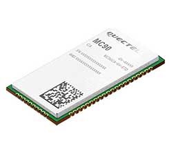
According to the company, the module supports hybrid positioning technologies including GNSS, Cell ID and Wi-Fi aided positioning, and enables position tracking in both indoor and outdoor environments.
Quectel’s MC90 integrates the multi-GNSS system, including GPS, GLONASS, Galileo and QZSS, which makes it suitable for urban areas with high-rise buildings and complex environments, the company added.
The MC90 also adopts Wi-Fi hotspot positioning technology for blind spots and satellite coverage. It integrates multi-aiding positioning technologies to offer customers with optimized GNSS performance. It also supports EPO technology, which provides predicted Extended Prediction Orbit to speed up TTFF without the need of any extra server.
The MC90 features a compact design, low power consumption and supports dual SIM single standby function. According to Quectel, it can be used for a wide range of internet of things applications, including bicycle sharing, student ID card, vehicle tracker, wearable device, pet tracker, asset tracker, driving recorder and more.
Did you know Australia doesn’t exist? (Sorry, Aussies.) The entire continent is part of a massive conspiracy designed to confuse you. Anyone who says they’re from Australia is an actor (paid by NASA, probably.) And all the airline pilots are “in on it,” flying people to a carved out section of South America.
The “rationale” (I use the word very lightly) seems to be that Britain just wanted to dump its convicts in the ocean, so made up the continent to tell people where they were taking them.
These and other “theories” spouted by Flat Earthers are akin to falling down a rabbit hole where up is down and round is flat. How can they believe such nonsense?
The 1893 Orlando Ferguson map imagines Antarctica as a wall of ice around the world. (Image: Library of Congress/2011594831)
Last year, the flat Earth idea became national news when rapper B.o.B. used Twitter to jump on the flat Earth bandwagon, even starting a GoFundMe campaign to find Earth’s curve. B.o.B.’s campaign wants to “launch multiple weather balloons and satellites into space” to observe (and try to disprove) what centuries of science and technology have already confirmed. So far, he’s raised less than $7,000 of his $1 million target.
How do Flat Earthers explain GPS? Is there a way to convince them that they’re wrong? Probably not. Anyone who tries is met with an argument that their evidence is faked or faulty. GPS satellites aren’t in space — there’s a “celestial dome” over the Earth. Or the signals are really from giant towers and the G stands for ground. Or Google has laid cables across the oceans to track you.
Astrophysicist Neil DeGrasse Tyson blames the educational system — not for teaching insufficient science subjects so much as needing to improve critical thinking skills. “Our system needs to train you not only what to know, but how to think about information, knowledge and evidence,” he said.
Should we bother to convince Flat Earthers they’re wrong? Some on the internet could be trolls toying with arguments and theories. True believers, however, are an extreme minority, and there will always be people who choose to believe in “alternative facts.” Let’s hope they remain a minority.
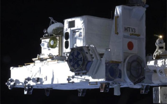
Europe’s satellite navigation system Galileo is already in use worldwide, usable by itself or in combination with the U.S. GPS. Now a combined Galileo–GPS positioning fix has been achieved in space — aboard the International Space Station — through an ESA–NASA collaboration.
In April, the chest-sized SCaN (seen left of center with an antenna on top) was used to make the first combined Galileo-GPS positioning fix in orbit from the ISS. (Photo: ISS)
Low-Earth orbiting satellites routinely make use of satellite navigation signals to pinpoint their position in space and allow their paths through space to be fixed with extremely high accuracy, known as “precise orbit determination.”
So far, such positioning has mainly been performed using GPS, but this new test proves it can also be achieved on a dual-constellation basis with both GPS and Galileo — as well as through the sole use of Galileo.
The experiment is based on the use of a reconfigurable NASA receiver called the Space Communications and Navigation Testbed, SCaN, attached to the exterior of the ISS.
ESA’s Navigation Support Office, based at its ESOC control centre in Darmstadt, Germany, teamed up with its Radio Navigation Systems and Technology team, located at its ESTEC technical centre in Noordwijk, the Netherlands, and Italy’s Qascom company to develop the techniques, software and firmware required for the experiment, which was passed to NASA’s Glenn Research Center in Ohio for upload to the receiver.
The International Space Station. (Photo: ESA)
“SCaN is a versatile software-defined radio receiver in space for both telecommunications and navigation testing, delivered to the Station back in 2012,” said ESA radio-navigation engineer Pietro Giordano. “It made it possible, with suitable modifications, to demonstrate combined GPS-Galileo positioning determination of the ISS.”
The algorithm developed for the SCaN Testbed had to take account of the high dynamics involved, and resulting Doppler shifting of signals: not only are the Galileo and GPS satellites moving at orbital velocity, so is the ISS itself. Orbital information of all the satellites in both constellations was included in the algorithm, allowing SCaN to make a ‘warm start’ – to search out signals in the correct segments of the sky.
In February 2006, the Navigation Support Office inaugurated its modern Navigation Facility at the European Space Operations Center (ESOC) in Darmstadt, Germany. (Photo: ESA)
In February 2006, the Navigation Support Office inaugurated its modern Navigation Facility, at the European Space Operations Center (ESOC), in Darmstadt, Germany.
“Dual constellation fixes offer many advantages for space, providing extremely robust and high-precision positioning,” Pietro added. “More signals become available overall, and the quality of the Galileo Open service and modernised GPS signals are extremely good.”
Werner Enderle, overseeing the project at the Navigation Support Office noted, “These excellent first results, coming out of great teamwork within ESA, collaboration with industry and with our NASA partners, mark just the beginning of our project data analysis. Many other exciting results are expected related to signal aspects, precise orbit determination and positioning based on optimised algorithms.”
James J. Miller, GPS Sr. Technologist within the SCaN programme office at NASA Headquarters, commented: “We’ve been promoting interoperability of GPS and Galileo through a number of activities within the United Nation’s International Committee on Global Navigation Satellite Systems (GNSS). In particular, NASA, with ESA and other national space agencies, has been identifying benefits to be gained for high altitude users in the multi-GNSS Space Service Volume under development. By further demonstrating multi-GNSS capabilities in low Earth orbit, the drive for additional utility at geostationary orbit and beyond is only strengthened.”
Europe’s Galileo system began Initial Services for users in December 2016, and there are 22 Galileo satellites in orbit. The launch of four more Galileo satellites by Ariane 5 is scheduled for July 25, and will bring the constellation to 24 satellites plus two orbital spares.
ESA is developing dual Galileo-GPS receivers for the next generation of Earth-observing Sentinel satellites. The more precise the orbit determination, the more accurate the environmental data that can be returned to Earth.
Combined use of Galileo and GPS signals on an interoperable basis for positioning and precise orbit determination should bring significant advantages for space users in particular, set to provide a seamless navigation capability from low to high Earth orbits — and potentially beyond.
“This shows the versatility of the Galileo system and the use of the system for scientific and other purposes, way beyond traditional navigation services,” said Paul Verhoef, ESA’s Director of Navigation. “We have also started work to determine whether we can use Galileo, in combination with GPS and other systems, for navigation to the Moon.”
Ceva has launched the successor to its Ceva-Dragonfly NB1 solution targeting the NB-internet of things (IoT) market, the Ceva-Dragonfly NB2.
The Dragonfly NB2 is a highly integrated and modular solution optimized for Cat-NB2 (3GPP Release 14 eNB-IoT) that can seamlessly be incorporated into chips and modules by the multitude of companies looking to address the large and fast-growing cellular IoT space.
GNSS hardware package. For customers developing NB-IoT products that also require GNSS capabilities, Ceva-Dragonfly NB2 includes a new power-optimized GNSS hardware package, with GNSS RF receiver and multi-constellation digital front-end.
The GNSS package speeds up both acquisition and tracking tasks by up to 8 times compared to Ceva-Dragonfly NB1, enabling a host of popular NB-IoT use cases, including people, livestock and asset tracking, and geo-fencing, the company said.
IoT boom forecast. In the latest edition of the Ericsson Mobility Report, the forecast for cellular IoT increased significantly, almost doubling to 3.5 billion connections for 2023. The report cites large-scale deployments in China and increasing interest in eNB-IoT and Cat-M1 cellular IoT standards as the catalysts for 30 percent CAGR between 2017 and 2023.
Ceva-Dragonfly NB2 is a licensable Rel14 compliant eNB-IoT solution and builds on the success of Ceva-Dragonfly NB1, which has been widely licensed for a range of use cases and emerging end markets, including smart cities, transport and logistics and consumer electronics. It is centered on the Ceva-X1 DSP/control processor featuring an enhanced Instruction Set Architecture and provides a unified processor environment for both physical layer and protocol stack workloads.
The solution also includes a highly integrated, worldwide enabled RF transceiver, a power amplifier (PA) and all the associated hardware and software modules required to develop a complete eNB-IoT product, ensuring the lowest possible bill-of-materials (BOM) in the process.
In addition to the performance improvements enabled by Release 14 including higher data rates and lower latency, Ceva-Dragonfly NB2 features a range of enhancements to ensure higher performance, added functionality and increased security for NB-IoT applications compared to its predecessor.
A new power management solution, complete with intelligent sleep mechanisms ensures ultra-low sleep power consumption of a few microAmps, further improving the battery life critical to every NB-IoT device.
The enhanced RF design is already silicon-proven at 55nm and 40nm processes, further lowering the entry barriers for customers with no previous cellular expertise to enter this burgeoning market.
Ceva-Dragonfly NB2 also includes the fully optimized physical layer and protocol stack firmware designed for Release 14 Cat-NB2. The addition of an on-chip embedded flash memory and controller now allows full NB-IoT design on a single die which further reduces BOM and power consumption.
Voice trigger. Ceva-Dragonfly NB2 also supports use cases requiring always-listening voice trigger, voice commands and sound sensing. The flexibility of the Ceva-X1 IoT processor allows for these sensing features to be implemented in software. The Ceva ClearVox voice front-end software package, for example, can be used to ensure clear and intelligible voice pickup for use cases such as emergency calls and voice panic buttons. In terms of security, Ceva-Dragonfly NB2 integrates a completely redesigned secure platform, including smart interfaces to connect USIM or eSIM. Ceva also offers other complementary technologies addressing massive IoT, such as Bluetooth 5 dual-mode and low energy and Wi-Fi 802.11n/ac/ax, for short range connectivity which customers can leverage for their product designs.
“The widespread commercial deployment of NB-IoT is well underway across the globe and we’re proud to be at the forefront of technology innovation for long-range massive IoT,” said Michael Boukaya, vice president and general manager of the wireless business unit at Ceva. “With the introduction of Ceva-Dragonfly NB2, we have built on the considerable success we achieved with our first generation solution, and delivered a unique, silicon-proven eNB-IoT Release 14 solution for our customers that is unprecedented in terms of system completeness, performance and power efficiency.
“Moreover, the option of power-optimized GNSS, voice and sensing capabilities vastly increases the breadth of use cases our customers can address with this licensable solution,” Boukaya said. “There is no other IP company in the world today that can come close to offering such a complete solution for eNB-IoT and we’re excited to closely partner with our customers to create a whole new wave of applications and devices for the infinite Internet of Things.”
Ceva-Dragonfly NB2 is available for licensing now. Development kits and reference silicon will be available in the third quarter of this year.
Trimble has announced version 4.1 of Trimble Business Center office software that enables surveyors and geospatial professionals to simplify the creation of cadastral, GIS, infrastructure inspection and tunneling deliverables.
With the version 4.1 update, GNSS field data from GIS receivers (including the Trimble Geo 7X) can now be post-processed within Trimble Business Center to achieve high-quality feature locations. This allows enterprise-level organizations the flexibility to integrate both GIS and survey data within the same project environment and then link the high-quality locations directly to their Esri geodatabase.
Version 4.1 also provides seamless integration with Trimble Access 2018 field software to improve field-to-office productivity using new cloud-based data synchronization and workflow task management capabilities.
Version 4.1 adds new cadastral capabilities including proportioning, map checking and CAD drafting tools that streamline the creation of survey plans, plots and survey engineering digital deliverables.
For infrastructure inspection, construction as-built verification and volumetric applications, new projected surface tools enable professionals to analyze and compare data captured in the field against design. Point clouds from the Trimble SX10, Trimble VISION instruments, 3D laser scanners and unmanned aircraft system (UAS) platforms can be used for slope monitoring as well as to perform accurate volumetric, deformation and cut/fill analysis for retaining wall, dams and mining applications.
A new optional Tunneling Module enables survey and engineering professionals to simplify their workflow and improve productivity to meet time-sensitive deadlines for tunnel construction projects. Tunnel designs can be created and exchanged with Trimble Access field software, enabling customers to easily stakeout tunnel elements in the field and quickly produce as-built analysis and reports in the office.