Harxon showcased high-precision positioning GNSS antennas and its latest wireless data-transmission technologies for UAV applications at AUVSI Xponential, which was held April 30-May 4 in Denver.
The Harxon D-Helix Antenna.
Harxon’s D-Helix is a patented D-QHA (dual-quadrifilar helix antenna) multi-constellation antenna supports excellent reception of GPS, Galileo, BeiDou and GLONASS, as well as L-band signals. Harxon D-QHA technology ensures the ability of low elevation satellites tracking while maintaining 4-dBi high gain, which makes the D-Helix antenna an excellent choice for any applications where the sky is partially visible, the company said.
The antenna’s low noise amplifier (LNA) with out-of-band rejection performance can suppress electromagnetic interference. Moreover, the D-Helix features the latest low wind resistance design with ruggedized IP67 protection for UAV inspection and monitoring, survey and mapping or agricultural UAVs.
Photo: Harxon
The HX-DU2017D is a 5-gram frequency-hopping OEM transceiver supporting frequencies between 840 MHz and 900 MHz. It provides strong anti-jamming and signal receiving capability for complex data intensive applications. Its full duplex mode ensures data secure transmission, more stable long-range communication and short latency of data transmission.
Watch this video to learn more about the HX-DU2017D.
Other showcased Harxon GNSS products, such as Helix Antenna HX-CH7603A, HX-CH4601A and HX-CH6601A, are all featured with patented D-QHA technology. Moreover, the showcased Survey Antenna GPS 500, OEM Modem HX-DU1018D and Smart Antenna are also appropriate for surveying and mapping, as well as precision agriculture.
Wingtra has officially launched the WingtraOne PPK high-precision mapping drone. Wingtra said its drone, which features vertical take-off and landing, is designed to set a new benchmark for large-scale surveying and mapping applications.
WingtraOne PPK offers large area coverage, ultra-high accuracy and brilliant image resolution. It features an advanced PPK module and high-quality cameras like the 42-megapixel full-frame camera Sony RX1RII, it is now possible to reach down to 1-centimeter absolute accuracy in aerial mapping.
To prove this accuracy claim, the Wingtra team performed test flights in a gravel quarry. The process was documented and is now explained in a white paper on the company website.
Conventional drone mapping on centimeter accuracy requires ground control points (GCPs) to correct the final map. Besides requiring additional surveying equipment and being extremely time consuming, setting up GCPs might be downright risky or just not possible in the area of interest.
More advanced solutions achieve similar levels of accuracy by using GPS correction technology for the georeferencing of the aerial imagery: namely RTK (real-time kinematics) or PPK (post processed kinematics).
RTK requires real-time base station connectivity and corrects GPS signals during the flight, while PPK corrects them after the flight and therefore offers greater robustness and consistency.
Moreover, PPK is independent from base stations or base station networks. It is highly reliable, accurate and time saving to use, Wingtra said. Neither special flight preparations nor intensive post-processing steps are required to achieve down to 1-cm accurate aerial maps.
In a notice advisory to NAVSTAR Users (NANU), the U.S. Coast Guard Navigation Center announced that starting March 7, after 22:00 Zulu hours, GPS will transition satellite SVN34 (PRN18) into the broadcast almanac for all satellites.
The almanac transition, one satellite at a time, will require approximately 24 hours to complete.
Also, on approximately March 8, SVN34 will resume transmitting L-band utilizing PRN18. SVN34/PRN18 will be unusable until further notice.
Future NANUs will notify users of any changes to the above stated status.
Contact the navigation center for more information:
A U.K. government report issued on Jan. 30 looks at the vulnerability of all satellite-based positioning systems: GPS, Galileo, GLONASS, BeiDou, QZSS and more. Issued by the Office of the Government Chief Scientific Adviser, Sir Mark Walport, and informally called the Blackett Report, designating the highest level of government scientific studies, named after a UK physicist who won the 1948 Nobel Prize, the review aims to “lay out the breadth, scale and implications of our reliance on ‘the invisible utility’ mainly in terms of existing critical national infrastructure (CNI).”
“Satellite-derived Time and Position: A Study of Critical Dependencies” states in the forward that it “represents a vital step in understanding the UK’s dependency on GNSS and recommends measures to improve our resilience. Importantly, it also recognises that innovation will be key to realising, fully and safely, the economic and societal benefits offered by GNSS.”
The report points to the fragility of satellite positioning signals which can be affected by cheap jammers, spoofers, weather and interference from other radio signals — among other vulnerabilities. The 86-page PDF document is downloadable here.
The review incorporates the results of a separate but related study, issued in April 2017, looking at the fiscal consequences of a GNSS disruption in. “Economic Impact to the U.K. of a Disruption in GNSS” was briefly summarized in a June 2017 column from this magazine (scroll down to “At What Cost Ignorance?”). The report attempted to quantify the cost of a GNSS disruption, should one occur. The authors came up a figure of 5.2 billion pounds ($6 billion) for a 5-day disruption.
David Last, a UK consultant engineer specializing in radio navigation and communications systems, professor emeritus at the University of Bangor, Wales and past president of the Royal Institute of Navigation, consulted on the June 2017 economic impact report, and was a member of the expert panel and co-author of the January 2018 Blackett Report. He was to have given a presentation on them at the ION International Technical Meeting in Reston, Virginia on January, but could not make the trip. The following materials are drawn from his prepared presentation.
Some of the conclusions from the June 2017 economic impact study are:
There are alternatives to GNSS, specific to each application
However, there is no universally-applicable single alternative for positioning and navigation
Among the most salient needs: higher quality (more expensive) oscillators for timing
“The most applicable mitigation strategies for the largest number of applications are eLoran and Satelles.”
“Omnisense and Locata may be preferred for localised applications that require high levels of accuracy.”
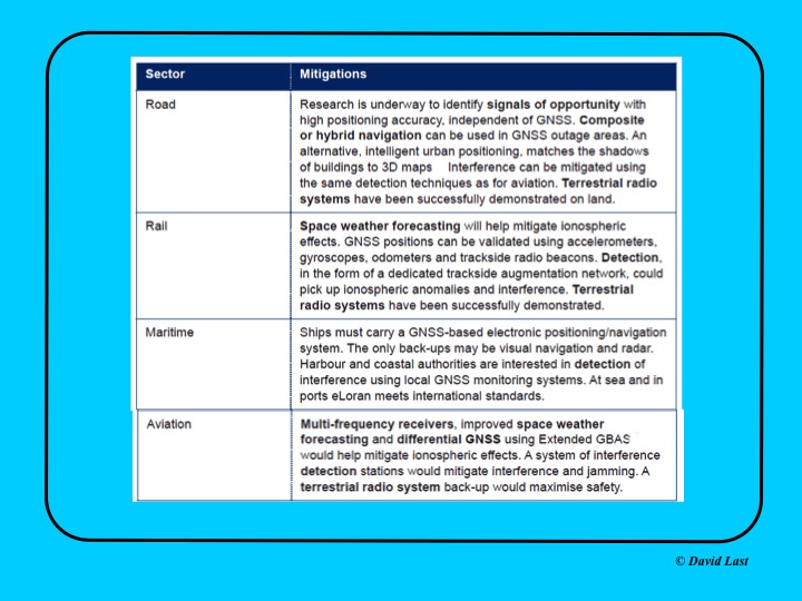
From the just-issued Blackett Report, the first figure displayed above presents recommended mitigations to impacts on GNSS applications in road, rail, maritime and aviation. Alternative options include composite or hybrid navigation, terrestrial radio systems, space weather forecasting, eLoran, various methods of interference detection, multi-frequency receivers and differential GNSS.
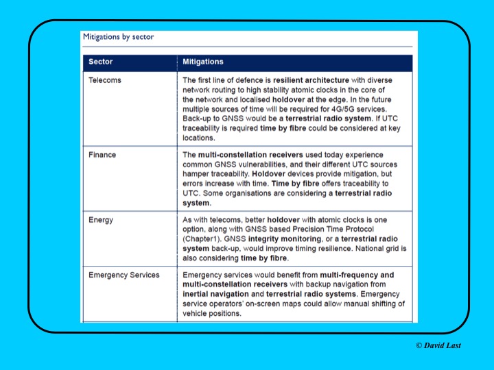
A second figure from Last’s presentation, shown above, covers the mitigations recommended for telecoms, finance, energy, and emergency services sectors. Mitigations for these applications include a resilient architecture with diverse network routing to high-stability atomic clocks, terrestrial radio systems, time-by-fiberoptics, multiconstellation receivers, holdover devices, GNSS integrity monitoring, and inertial navigation.
Concluding recommendations of the Blackett Report:
CNI operators to review and report on their reliance on GNSS. Cabinet Office to assess overall dependence of CNI on GNSS.
Add loss or compromise of GNSS-derived PNT to National Risk Assessment, not just as a dimension of space weather.
In allocating radio spectrum to new services and applications, address the risk of interference to GNSS-dependent users, including CNI.
Review the legality of the sale, ownership and use of devices and software to cause deliberate interference to GNSS receivers or signals.
Assess the need to monitor interference of GNSS at key sites such as ports and share the data with government
Employ GNSS-independent back-up systems.
Cross-government PNT Working Group to report to Cabinet Office on ways to improve national resilience.
Government to facilitate as those procuring GNSS equipment for CNI specify performance standards.
Map PNT testing facilities and explore how industry and critical services can better access them.
Leverage UK academic and industrial expertise in time and geo-location, increasing coordination among existing centres of excellence.
The Japan-Australia QZSS Industrial Utilisation Workshop will be held Feb. 6 at the University of New South Wales (Kensington Campus), Room Chemical Sc M18, Sydney, Australia.
The workshop will share information about QZSS and GPS related technologies and the latest developments in the applications of this technology in a range of sectors including in agriculture, autonomous driving, advanced route guidance and the maritime sector.
The workshop will explore avenues for future cooperation with Australian organisations, both in the private and public sectors and report on trials undertaken in Australia using QZSS applications.
The QZSS Workshop will feature a range of keynote speakers from key Japanese Ministries including: the Ministry of the Economy and Industry (METI), the National Space Policy Secretariat (Cabinet Office), the Ministry of Internal Affairs and Communications (MIC) , Ministry of Agriculture, Forestry and Fisheries (MAFF) and Japanese industry, including Toyota Tsusho, Mitsubishi Electric (MELCO), Global Positioning Augmentation Service Corporation (GPAS), Hitachi Zosen Corporation (HITZ), as well as keynote speakers from the Australian public and private sectors.
EGNOS V3 will offer improved and secure Civil Aviation Safety of Life services for the next decade over Europe. The program will ensure a full continuity of service and will be the first operational SBAS using both GPS and Galileo.
Airbus has been selected by the European Space Agency (ESA) as the prime contractor to develop EGNOS V3, the next generation of the European Satellite Based Augmentation System (SBAS) planned to provide the civil aviation community with advanced safety-of-life services and new services to maritime and land users.
Developed by ESA on behalf of the European Commission and the European GNSS Agency (GSA), EGNOS V3 (European Geostationary Navigation Overlay Service) will provide augmented operational safety-of-life services over Europe that improve the accuracy and availability of user positioning services from existing GNSS (Galileo and GPS).
EGNOS also provides crucial integrity messages to EGNOS users with alerts within a few seconds in case of system degradation, consolidating EGNOS’ position as one of the leading edge GNSS systems in the future.
Besides improved safety-of-life services, EGNOS V3 will improve robustness against increasing security risk, in particular cyber-security risks.
EGNOS V3 will ensure a full continuity of service for the next decade and will be the first operational SBAS implementing the dual-frequency and multi-constellation world standard, with both GPS and Galileo, replacing EGNOS V2 which has been in operation since 2011.
“This programme is strategic for Airbus to strengthen our position in the Navigation field. The signature of this contract is the result of more than 5 years of intense team work and investment,” said Nicolas Chamussy, head of Space Systems at Airbus. “With our consortium, we bring a large pool of resources and experience in Europe covering the successful development of critical and secure ground segment. I am confident that we will make EGNOS V3 a success story.”
As prime contractor, Airbus will be leading a consortium with partners from France, Germany, Spain and Switzerland. Airbus will be responsible for the development, integration, deployment and preparation of EGNOS V3 operations, the overall performance of the system and the Central Processing Facility, which is the heart of the real-time navigation algorithms.
During the 6.5-year contract, around 100 people and 20 subcontractors will work on delivering the EGNOS V3 system. In 2023, the single-frequency version will be available to replace the current operational version and, 18 months later, the final version in dual frequency will be delivered.
EGNOS is composed of a large network of about 50 ground stations deployed over Europe, Africa and North America, two master control centers near Rome and Madrid, and a System Operation Support Centre in Toulouse. EGNOS will also use geostationary satellite navigation payloads.
The United States and China have negotiated compatible signal characteristics that will both protect and enhance service for users of the U.S. GPS and Chinese BeiDou constellations.
The achievement resulted from several years of discussions between U.S. and Chinese GNSS experts. The consensus to make the systems compatible and interoperable at the user level will mean better service for users of both systems worldwide.
The U.S.Department of State’s Bureau of Oceans and International Environmental and Scientific Affairs Office of Space and Advanced Technology represents the United States in the ongoing U.S.-China GNSS Cooperation Dialogue, which began in May 2014 and covers various topics.
Compatibility of the Chinese BeiDou Navigation Satellite System (BDS) with GPS has been a core focus of the discussions. The U.S.-China Joint Statement on signal compatibility and interoperability is below and on the gps.gov website.
Joint Statement on Civil Signal Compatibility and Interoperability Between the Global Positioning System (GPS) and the BeiDou Navigation Satellite System (BDS)
December 4, 2017
In May 2014, China Satellite Navigation Office and the Office of Space and Advanced Technology, U.S. Department of State, jointly established the U.S.-China Civil GNSS Cooperation Dialogue, a bilateral government-to-government mechanism to promote cooperation between the U.S. Global Positioning System (GPS) and the Chinese BeiDou Navigation Satellite System (BDS).
Over the past three years, representatives and experts from both sides have studied and discussed various topics related to civil service provision and user applications, among which BDS compatibility and civil interoperability with GPS is one of the core focus areas.
Both sides have carried out extensive in-depth analysis, and have engaged in persistent discussion and coordination.
As a result, the two sides have reached the following consensus conclusions regarding compatibility and interoperability between GPS and BDS:
Consistent with the bilateral frequency compatibility coordination completed in 2010, GPS and BDS are radio frequency compatible under the framework of the International Telecommunication Union (ITU); and
The GPS L1C and BDS B1C civil signals, using two different types of multiplexed binary offset carrier (MBOC) waveforms are interoperable, which means users can receive better service by jointly using these civil signals without a significant increase in receiver cost or complexity.
Both sides agree to continue their consultations and cooperation related to compatibility and interoperability in order to provide better services for global users.
(signed by)
Ran Chengqi, China Satellite Navigation Office
David A. Turner, Office of Space and Advanced Technology, U.S. Department of State
For more information, contact [email protected]. Follow the Bureau of Oceans and International Environmental and Scientific Affairs on Twitter at @StateDeptOES.
SimActive Inc., a developer of photogrammetry software, has launched an automated solution for direct georeferencing from real-time kinematic (RTK) positioning.
Within the new workflow feature, users can achieve get high accuracy in projects without the use of ground control points (GCP), saving time in collecting and processing data.
Martin Instrument, a reseller of SimActive and surveying equipment, is benefitting from the automation. “Direct georeferencing greatly helps reducing cost for applications like corridor mapping,” said Mike Minick, vice president of sales at Martin Instrument. “The new automated option within SimActive software for direct georeferencing greatly facilitates the user workflow.”
“With RTK GPS available on drones, the use of direct georeferencing is growing within the industry,” said Louis Simard, CTO of SimActive. “Correlator3D allows users to maximize their hardware and software investment.”
For a live demonstration at the Commercial UAV Show (Nov. 15-16, London, United Kingdom), visit SimActive’s booth or send an email to [email protected].
Q: What is the GNSS/PNT industry “Issue of the Year”?
Jose Angel Avila Rodriguez, signal and security implementation engineer, European Space Agency
A: The growth of PNT applications has been impressive and will continue. Assurance of PNT will thus gain an ever-increasing role, in both the security and the civil domains.
For GNSS, the key PNT contributor, there is in addition another challenge: its piece in the PNT cake will be contested by newcomers, such as telecom networks. Whether we will continue talking about A-GNSS or instead talk about Assisted 5G, with GNSS in that case taking on the role of signal of opportunity — that will depend on today’s decisions about future GNSS upgrades, the modernized versions of Galileo second generation, GPS III, and Beidou/Compass III, that will be flying around 2040.
Gyles Panther, president and CTO, Tallysman Wireless, Inc.
A: The key issues for PNT going forward, and into the indefinite future, are simply stated: availability and accuracy. Re-deployment of the eLoran infrastructure is a no-brainer. A potentially highly negative step would be the introduction of communication services within the mobile satellite L-band downlink frequency band (1525 MHz to 1559 MHz). Multi-constellational receivers track a much larger number of satellites and better disposed SVs (space vehicles) provide a lower horizontal DOP and hence greater accuracy.
Finally, GNSS needs to be defended against interference both intentional and accidental. Why on earth would we want to damage something that is providing so much utility to mankind?
Using live data from USGS and Waze, a new Esri interactive map visualizes active wildfire locations and traffic alerts for Northern California.
The map incorporates a new mapping technique to group traffic alerts at locations where there is a high density of alerts. This method enables faster and more effective visual analysis in areas where there are many alerts that would normally overlap. Zoom in on the map to reveal the latest individual traffic alerts.
Active fire data displays the locations of large fire incidents in Northern California. Data is provided by the U.S. Department of Agriculture Forest Service and The Geospatial Multi-Agency Coordination Group, and is intended to give near real-time understanding of the situation on the ground.
Location and status of active fires is updated throughout the day as new information is gathered by first responders.
Data from Waze is reported by users of Waze and updated every 2 minutes. This data, provided by Waze through the Connected Citizens Program, contains filtered data for affected area including system-generated traffic jams and user-reported traffic incidents (including jams, accidents, hazards, construction, potholes, roadkill, stopped vehicles, objects on road, and missing signs).
Old Faithful is Yellowstone National Park’s most famous landmark. Millions of visitors come to the park every year to see the geyser erupt every 44 to 125 minutes. But despite Old Faithful’s fame, relatively little was known about the geologic anatomy of the structure and the fluid pathways that fuel the geyser below the surface. Until now.
University of Utah scientists have mapped the near-surface geology around Old Faithful, revealing the reservoir of heated water that feeds the geyser’s surface vent and how the ground shaking behaves in between eruptions. The map was made possible by a dense network of portable seismographs and by new seismic analysis techniques. The results are published in Geophysical Research Letters. Doctoral student Sin-Mei Wu is the first author.
For Robert Smith, a long-time Yellowstone researcher and distinguished research professor of geology and geophysics, the study is the culmination of more than a decade of planning and comes as he celebrates his 60th year working in America’s first national park.
“Here’s the iconic geyser of Yellowstone,” Smith says. “It’s known around the world, but the complete geologic plumbing of Yellowstone’s Upper Geyser Basin has not been mapped nor have we studied how the timing of eruptions is related to precursor ground tremors before eruptions.”
A portable seismometer used to map the geology beneath Old Faithful. (Photo: Paul Gabrielsen)
Small seismometers
Old Faithful is an iconic example of a hydrothermal feature, and particularly of the features in Yellowstone National Park, which is underlain by two active magma reservoirs at depths of 5 to 40 km depth that provide heat to the overlying near-surface groundwater. In some places within Yellowstone, the hot water manifests itself in pools and springs. In others, it takes the form of explosive geysers.
Dozens of structures surround Old Faithful, including hotels, a gift shop and a visitor’s center. Some of these buildings, the Park Service has found, are built over thermal features that result in excessive heat beneath the built environment. As part of their plan to manage the Old Faithful area, the Park Service asked University of Utah scientists to conduct a geologic survey of the area around the geyser.
For years, study co-authors Jamie Farrell and Fan-Chi Lin, along with Smith, have worked to characterize the magma reservoirs deep beneath Yellowstone. Although geologists can use seismic data from large earthquakes to see features deep in the earth, the shallow subsurface geology of the park has remained a mystery, because mapping it out would require capturing everyday miniature ground movement and seismic energy on a much smaller scale. “We try to use continuous ground shaking produced by humans, cars, wind, water and Yellowstone’s hydrothermal boilings and convert it into our signal,” Lin says. “We can extract a useful signal from the ambient background ground vibration.”
To date, the University of Utah has placed 30 permanent seismometers around the park to record ground shaking and monitor for earthquakes and volcanic events. The cost of these seismometers, however, can easily exceed $10,000. Small seismometers, developed by FairfieldNodal for the oil and gas industry, reduce the cost to less than $2,000 per unit. They’re small white canisters about six inches high and are totally autonomous and self-contained. “You just take it out and stick it in the ground,” Smith says.
In 2015, with the new instruments, the Utah team deployed 133 seismometers in the Old Faithful and Geyser Hill areas for a two-week campaign.
The sensors picked up bursts of intense seismic tremors around Old Faithful, about 60 minutes long, separated by about 30 minutes of quiet. When Farrell presents these patterns, he often asks audiences at what point they think the eruption of Old Faithful takes place. Surprisingly, it’s not at the peak of shaking. It’s at the end, just before everything goes quiet again.
After an eruption, the geyser’s reservoir fills again with hot water, Farrell explains. “As that cavity fills up, you have a lot of hot pressurized bubbles,” he says. “When they come up, they cool off really rapidly and they collapse and implode.” The energy released by those implosions causes the tremors leading up to an eruption.
One scientist’s noise is another scientist’s signal
Typically, researchers create a seismic signal using an active source, such as swinging a hammer onto a metal plate on the ground or setting off an explosion. Lin and Wu developed the data analysis method that would help find useful signals among the seismic noise without disturbing the sensitive environment in the Upper Geyser Basin. Wu says she was able to use the hydrothermal features themselves as a seismic source, to study how seismic energy propagates by correlating signals recorded at the sensor close to a persistent source to other sensors. “It’s amazing that you can use the hydrothermal source to image the structure here,” she says.
The model of Old Faithful’s hydrogeological system suggested by the study’s results. (Image: Sin-Mei Wu)
When analyzing data from the seismic sensors, the researchers noticed that tremor signals from Old Faithful were not reaching the western boardwalk. Seismic waves extracted from another hydrothermal feature in the north slowed down and scattered significantly in nearly the same area suggesting somewhere west of Old Faithful was an underground feature that affects the seismic waves in an anomalous way. With a dense network of seismometers, the team could determine the shape, size, and location of the feature, which they believe is Old Faithful’s hydrothermal reservoir.
Wu estimates that the reservoir, a network of cracks and fractures through which water flows, has a diameter of around 200 meters, a little larger than the University of Utah’s Rice-Eccles Stadium, and can hold approximately 300,000 cubic meters of water, or more than 79 million gallons. By comparison, each eruption of Old Faithful releases around 30 m3 of water, or nearly 8,000 gallons. “Although it’s a rough estimation, we were surprised that it was so large,” Wu says.
Further work
The team is far from done answering questions about Yellowstone. They returned for another seismic survey in November 2016 and are planning their 2017 deployment, to begin after the park roads close for the winter. Wu is looking at how subsurface structure and hence the propagation of seismic waves can change with time. Farrell is using the team’s seismic data to produce even higher resolution subsurface images and predict how earthquake waves might reverberate through the region.
Smith is looking forward to conducting similar analysis in Norris Geyser Basin, the hottest geothermal area of the park. Lin says that the University of Utah’s research program in Yellowstone owes much to Smith’s decades-long relationship with the park, enabling new discoveries. “You need new techniques,” Lin says, “but also those long-term relationships.”
The full study can be found here. The research was funded by the National Science Foundation and by King Abdullah University of Science and Technology, the Brinson Foundation and the Carrico Fund. Fan-Chi Lin is the Principal Investigator.
Paul Gabrielsen is a science writer at University of Utah Communications.
DOT serves as the civil lead for the GPS and chairs the CGSIC in this capacity. NAVCEN is assigned duties as deputy chair and executive secretariat for the CGSIC.
Subcommittees of the CGSIC for Timing, State and Local Government, International Information, and Survey, Mapping and Geosciences will hold meetings Sept. 25, and a summary of these meetings will be presented to the CGSIC plenary session Sept. 26.
The keynote speaker for this year’s plenary session will be Keith Conner, Ph.D., Senior Engineer, Science and Technology First Responders Group, U.S. Department of Homeland Security.
Presentations include:
Operational status and modernization of the GPS constellation of satellites
U.S. Space-Based Position, Navigation and Timing policy
GPS augmentation systems
Briefings from the National Aeronautics and Space Administration (NASA) and the National Parks Service
Information related to U.S. engagement with other international Global Navigation Satellite Systems as well as a variety of applications of the use of GPS
The full agenda is available. CGSIC presentations will be posted online shortly after the meeting ends.