Category: GNSS

  • Thales Alenia Space’s advanced technology to respond to distress signals

    Thales Alenia Space’s advanced technology to respond to distress signals

    The European Commission (EC) has awarded Thales Alenia Space a contract to develop and build an operational ground station on La Reunion Island to track GNSS satellites in medium Earth orbit. The ground station will be an operational part of the Galileo search-and-rescue (SAR) system.

    The contract includes one Medium Orbit Local User Terminal (MEOLUT), engineering support and maintenance services for one year, and the hosting site on La Reunion Island.

    Using Thales Alenia Space’s powerful and compact MEOLUT Next phased-array solution, the EC and European GNSS Agency (GSA) will improve their contribution to the Cospas-Sarsat system.

    Thales Alenia Space is a joint venture between Thales (67 percent) and Leonardo (33 percent).

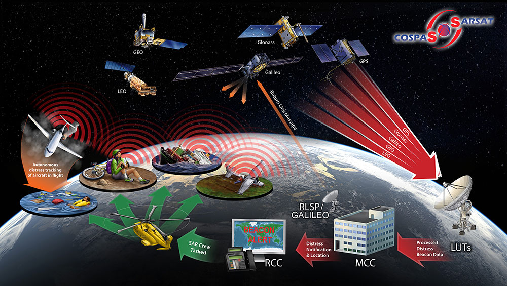
    The ground station will receive and process 406-MHz distress beacon signals from the MEO satellites being tracked, and relay them to the SAR/Galileo network via the French Mission Control Center (FMCC) at the CNES facility in Toulouse. The contract also included the procurement of the best possible hosting site for this ground station.

    Image: International Cospas-Sarsat Programme
    Image: International Cospas-Sarsat Programme

    This MEOLUT Next will enhance the EC’s contribution to the Cospas-Sarsat SAR system by extending its coverage in the South Indian ocean, contributing to worldwide coverage. It complements the three MEOLUTs that are already deployed around Europe —  in Larnaca (Cyprus), Maspalomas (Grand Canaria) and Spitzbergen (Norway) — and under responsibility of the GSA.

    The MEO system, which replaces the legacy LEO (low Earth orbit) system, is designed to offer a faster response and better location data in near real time for search-and-rescue authorities, using spacecraft and ground facilities to detect and locate signals from the 406-MHz distress beacons.

    The MEOLUT Next will also support the second generation of Cospas-Sarsat beacons. The SAR/Galileo site on La Reunion will be fitted with reference and calibration beacons to monitor the performance of the extended SAR ground segment and precisely calibrate MEOLUT measurements.

    “Using Thales Alenia Space’s powerful and compact MEOLUT Next phased array solution, the European Commission will benefit from the world’s first spaceborne search & rescue system of this type,” said Philippe Blatt, vice president, Navigation France at Thales Alenia Space. “We are very proud that our advanced technology is now recognized by many customers worldwide. The performance logged by our MEOLUT Next units in service far exceeds requirements, which not only benefits our customer countries, but also makes travel even safer. It’s worth remembering that the Cospas-Sarsat system, operational since 1988, saves some 1,500 lives a year.”

    Thales Alenia Space designs, operates and delivers satellite-based systems for governments and institutions, helping them position and connect anyone or anything, everywhere. Since commissioning in 2016, MEOLUT Next has delivered unrivaled performance, detecting distress signals from more than 5,000 kilometers away. Several countries have already chosen or are interested in the technology, including Canada and Togo.

  • ESA launches new Galileo app competition

    ESA launches new Galileo app competition

    European students and researchers are invited to compete in a new Galileo smartphone app competition sponsored by the European Space Agency (ESA).

    The goal is to develop an app capable of performing fixes using raw Galileo satnav measurements. An earlier Galileo smartphone app competition has already resulted in the winning app becoming publicly available.

    This year’s event challenges teams to make use of the dual-frequency capability of the latest Android 8.0 smartphones, to compute dual-frequency positioning solutions from raw satnav signals to compare them with their single frequency equivalents.

    The competition is run by ESA in collaboration with the European Global Navigation Satellite Systems Agency (GSA) plus the European Commission with the support of Google.

    The Galileo app competition is open to all students from European universities and trainees in posts at European research and development organizations.

    “The inaugural Galileo smartphone app competition was open solely to ESA graduate trainees, but the response was so great that this time we have opened up to students and young researchers across Europe, forming teams of three to five people,” explained ESA Galileo Services Engineering Manager Rafael Lucas Rodriguez.

    The set objective is to reach sub-meter accuracy worldwide in unobscured sky conditions. The app should allow the user to select Galileo-only positioning, GPS-only positioning and the combination of both on a simultaneous basis, with the potential to include other satnav constellations in turn.

    The receiver chipsets inside smartphones routinely make use of Galileo in combination with several other satnav constellations — the U.S .GPS, Russian GLONASS and Chinese BeiDou. These chipsets function in “black box” style, making the resulting positioning fixes accessible to users, but without giving any option to the user to select which constellation to employ — or information on Galileo’s particular contribution to the phone’s overall positioning performance.

    However, in newer Android smartphones it has become possible to access the raw signal measurements used to compute position, opening the door to the development of applications where the user can indeed select which constellations to employ.

    The very latest models also allow the use of dual satnav frequencies, giving a major boost to positioning precision. The higher chip rate of the additional frequency allows the chipset to compensate for signal propagation errors from the signals’ journey through the ionosphere — the electrically active outer layer of atmosphere — and reduces false ‘multipath’ detections caused by signals reflecting off buildings.

    “As a first step, teams submit a proposal of not longer than 20 pages, summarizing the application to be developed,” explained ESA navigation engineer Nityaporn Sirikan. “These proposals will be evaluated by a jury composed of representatives of ESA, GSA, the EC and Google, with the top five proposals selected to develop their app further, receiving on loan a state-of-the-art dual frequency satnav smartphone and receiving general guidance and technical support.”

    The competition launched on Sept. 24; teams are invited to submit their proposals to [email protected] by Nov. 12, and will be informed of the jury’s response to their proposal by Nov. 26. The competition final is scheduled for April 18, 2019, at ESA’s ESTEC technical centre in Noordwijk, the Netherlands. Terms and conditions of the competition are posted here.

    The first- and second prize-winning teams will win attendance to the ESA and EC International Summer School on Global Navigation Satellite Systems in Portugal. Additional prizes will be available to the most innovative app and the winner of a public online vote, to be undertaken during the final.

  • Graduate student Yu Jiao receives ION’s Parkinson Award

    Graduate student Yu Jiao receives ION’s Parkinson Award

    The Institute of Navigation presents Yu Jiao with the Parkinson Award at ION GNSS+ 2018. (Photo: ION)
    The Institute of Navigation presents Yu Jiao with the Parkinson Award at ION GNSS+ 2018. (Photo: ION)

    Yu Jiao was recognized for graduate student excellence in GNSS by the Institute of Navigation’s (ION) Satellite Division on Sept. 28 at the ION GNSS+ Conference in Miami. She received the Bradford W. Parkinson Award for her thesis, “Low-Latitude Ionospheric Scintillation Signal Simulation, Characterization and Detection on GPS Signals.”

    Jiao received her Ph.D. at Colorado State University, with Jade Morton as her advisor. She graduated this past year and is now employed as a GNSS engineer at Intel.

    The Bradford W. Parkinson Award is granted annually to recognize an outstanding graduate student in GNSS, and is presented in honor of Bradford W. Parkinson for his leadership in establishing the U.S. Global Positioning System and for his work on behalf of the Satellite Division of the Institute of Navigation.

    Any graduate student who is a member of the ION and is completing a degree program with an emphasis in GNSS technology, applications or policy is eligible for the award.

  • Munich SatNav Summit 2019 to focus on augmented reality

    Experts from all over the world will discuss positioning, navigation and timing (PNT) and their role for augmented/mixed reality at the Munich Satellite Navigation Summit 2019. The summit will take place March 25-27, 2019, at the Alte Kongresshalle in Munich, Germany.

    “Augment Yourself with GNSS…” is the theme of the 2019 summit. The organizing Institute of Space Technology and Space Applications (ISTA) of the Universitaet der Bundeswehr Muenchen will invite experts to talk about the latest GNSS and PNT news and their role for augmented/mixed reality as well as other up-to-date technologies.

    The conference starts on March 25 with the Exhibition Opening and Champagne Reception at 16:00 hours, followed by the Opening Plenary Panel at 16:45 hours. Afterwards, a reception provides opportunities for high-level networking with experts from industry, science and government.

    Trending topics of the 2019 summit:

    • First- and second-generation of the European satellite navigation system Galileo
    • Modernization of the U.S. Global Positioning System
    • Status and modernization of the Russian Global Satellite Navigation System GLONASS
    • Developments of new global and regional systems like the Chinese Beidou (BDS), the Japanese QZSS and the Indian IRNSS
    • Augmented/mixed reality and the use of Android raw measurements
    • Autonomous systems
    • Civil use of the Public Regulated Service
    • GNSS satellites and the Space Service Volume
    • Legal aspects on selected topics in the field of GNSS.

    Learn more on the summit website.

  • China sends twin BeiDou navigation satellites into space

    China successfully sent twin BeiDou navigation satellites into space on Aug. 25, aboard a single carrier rocket, according to news reports. The satellites are numbers 35 and 36 in the BeiDou navigation constellation.

    Read more about the launch here.

  • Ravenswood gets contract for U.S. Army exercise tracking

    Ravenswood gets contract for U.S. Army exercise tracking

    Photo: U.S. Army/Pvt. Austin Anyzeski
    Photo: U.S. Army/Pvt. Austin Anyzeski

    Ravenswood Solutions has been awarded a $1.3 million contract to support the U.S. Army Joint Modernization Command (JMC) during an exercise this fall at Fort Bliss, Texas, and White Sands Missile Range, New Mexico.

    Ravenswood will provide support via its GPS-based Mobile Ground Truth System (MGTS) — also known as FlexTrain. The rapidly deployable system tracks individual vehicles, units and participants during exercises. Using the system, unit leaders can monitor events in real time and replay scenarios.

    The results are real-time casualty assessments, a record of factors affecting capabilities and operations.

    Ravenswood has trained more than 130,000 troops with FlexTrain. The MGTS has been successfully deployed in 60 x 80 kilometers areas and can track thousands of players, the company said.

  • SAE International issues new eLoran standards documents

    SAE International’s PNT Committee, a standards development working group within the Systems Management Council (SMC), has issued three new documents.

    The documents provide technical descriptions of the signal-in-space eLoran waveform and two accepted data channel techniques that include explanations and recommended practices.

    • SAE9990 − Transmitted Enhanced Loran (eLoran) Signal Standard. This transmitted eLoran signal standard provides technical descriptions of the waveform, specifications, and explanations. The data channel, receiver specification, and recommended practices are described in the SAE9990 family of standards.
    • SAE9990/1 − Tri-State Pulse Modulation Data Channel Modulation Techniques. This eLoran transmitted signal standard provides technical descriptions of a data channel based on the tri-state pulse position modulation technique. The eLoran transmitted signal standard, to which this data channel technique applies, is part of the SAE9990 family of standards covering data channels, receiver specifications, and recommended practices for eLoran.
    • SAE9990/2 − 9th Pulse Modulation Data Channel Modulation Techniques. This eLoran transmitted signal standard provides technical descriptions of the data channel using ninth pulse modulation techniques. The eLoran transmitted signal standard, to which this data channel technique applies, is part of the SAE9990 family of standards covering data channels, receiver specifications, and recommended practices for eLoran.

    The standards demonstrate the PNT Committee’s far-reaching vision and purpose of safeguarding the operations of the global economy and critical infrastructure from being overly dependent on single-source PNT services, SAE said.

    Noting that there is a growing consensus supporting the development of independent, complimentary, multi-domain PNT services that can interoperate with GPS and other GNSS, SAE is leading the charge to issue standards for eLoran.

    These three documents, when combined with future SAE PNT Committee work products, will define architectures, sensors, interfaces, training and certification recommended practices, so that the commercial marketplace can continue to develop products and capabilities to provide robust and resilient PNT solutions for consumers.

    In a field that is already experiencing unprecedented growth, these standards will promote the development of new PNT innovations, while also ensuring safe, secure and reliable operations for all modes of transport and other applications that exist on a foundation of accurate, reliable and trusted PNT capabilities, SAE said.

    As the PNT Committee is comprised of technical subject matter experts from private sector companies, consulting firms, government departments and others across the aerospace and defense industries, collaborative efforts result in mandated processes that empower users and enhance performance.

  • China launches yet more BeiDou navigation satellites

    China launches yet more BeiDou navigation satellites

    China sends twin BeiDou-3 navigation satellites into space on a single carrier rocket from Xichang Satellite Launch Center in Xichang, southwest China's Sichuan Province, Sept. 19, 2018. (Photo: Xinhua/Liang Keyan)
    China sends twin BeiDou-3 navigation satellites into space on a single carrier rocket from Xichang Satellite Launch Center in Xichang, southwest China’s Sichuan Province, Sept. 19, 2018. (Photo: Xinhua/Liang Keyan)

    On Sept. 19, China successfully sent twin BeiDou-3 navigation satellites into space on a single carrier rocket, according to state news agency Xinhuanet.

    This is the third launch of twin BeiDou-3 satellites in less than eight weeks. China launched two more pairs of BeiDou navigation satellites into space on July 29 and Aug. 25.

    The Long March-3B carrier rocket lifted off from the Xichang Satellite Launch Center at 10:07 p.m. It was the 285th mission of the Long March rocket series.

    The twin satellites are the 37th and 38th editions of the BeiDou navigation system. After a series of tests and evaluations, they will work together with 12 BeiDou-3 satellites already in orbit.

    The twin satellites will provide danger alerts and navigation services for global users. A basic system with 18 orbiting BeiDou-3 satellites will be in place by the end of the year, which will serve countries participating in the Belt and Road Initiative.

    The satellites and the rocket for Wednesday’s launch were developed by the China Academy of Space Technology and the China Academy of Launch Vehicle Technology, respectively.

  • GNSS Compare app now available for download

    GNSS Compare app now available for download

    Screenshot: TFI Systems
    Screenshot: TFI Systems

    The GNSS Compare app, winner of ESA’s Galileo Smartphone App Challenge, is now available for download on the Google Play Store for Android devices.

    Taking advantage of the recent release of Android API 24 and the GnssMeasurement class, developers now have access to unprocessed pseudorange measurements in certain smartphones.

    GNSS Compare is basically a tool for scientists to compare their algorithms. For those who are not GNSS experts, it can also serve as a teaching tool on the subject.

    The Galileo Smartphone App Challenge was about creating a smartphone application that will allow the user to choose which satellite constellation to use for PVT estimation.

    Screenshot: TFI Systems
    Screenshot: TFI Systems

    The aim was to increase the awareness about the European Union’s Galileo satellite navigation program and also to allow users from the public to compare the performance of Galileo signals with the performance from other global satellite navigation constellations.

    The app has been tested on Samsung Galaxy S8 and Xiaomi Mi 8 phones. To download, visit the store.

  • GPS problem reports now published on NAVCEN website

    GPS problem reports now published on NAVCEN website

    The U.S. Coast Guard Navigation Center (NAVCEN) is now publishing reports of GPS problems on its website. Any notes about problem resolution, if available, will also be listed.

    The website will be updated as new reports are received and processed. All reports made in 2018 are now available, and reports for prior years will be made available in the future.

    The reports are being made “to provide better service and situational awareness to the public,” wrote Rick Hamilton, CGSIC executive secretariat, NAVCEN.

    Reports of GPS problems submitted to NAVCEN through the GPS Problem Reporting webpage will be posted to the GPS Problem Report Status webpage after review by NAVCEN staff.

    Reports will be anonymized to protect the submitter’s personal information and any equipment manufacturer data.

    After user and interagency partner input has been collected, any findings will be added to the report along with the suspected cause and resolution, if available.

    The webpage will include the following information for each report:

    • Date/Time of Disruption: Date and time of the report as provided by the reporting source.
    • Date Submitted: Date the report was submitted to NAVCEN.
    • Location: The general location of the reported problem based on input from the reporting source. Latitude and longitude may be used for maritime reports.
    • Type: Installation type as provided by the reporting source. Choices include agriculture, automobile, aviation, communications, first responder, marine, law enforcement, research, surveying, timing, transportation and other (with a fillable field).
    • Description: Description of the problem. This information from the reporting source is edited for clarity and to remove personal and equipment manufacturer identifying details. The description also provides GPS satellite constellation analysis information as provided by the GPS Operations Center, a determination if authorized GPS testing might have been a factor, and information on correlating reports from other users and interagency partners.
    • Cause: The most likely cause of the report based on interagency input.
    • NAVCEN Closed Date: NAVCEN collects interagency input and provides a detailed response to the reporting source for each report submitted. If there are no further questions from the reporting source, and NAVCEN has no other correlating information, NAVCEN will close the case. The results of interagency input will be included in the description field when the case is closed. This date may not correspond to the event end date.

    Civil GPS users are encouraged to submit reports of GPS problems to the Coast Guard Navigation Center.

    Civil aviation users are encouraged to report GPS anomalies to the Federal Aviation Administration, and military users should contact the GPS Operations Center.