The U.S. Federal Communications Commission (FCC) granted in part the European Commission’s request for a waiver of the commission’s rules so that non-federal devices in the United States may access specific Galileo signals. While private users were free to use the European GNSS, with this ruling entities such as telecommunications companies can now also use Galileo.
With today’s action, consumers and industry in the United States will now be permitted to access the E1 and E5 Galileo signals to augment GPS.
Since the debut of the first consumer handheld GPS device in 1989, consumers and industry in the United States have relied on the U.S. GPS to support satellite-based positioning, navigation, and timing (PNT) services that are integral to everyday applications ranging from driving directions to precision farming.
The order, approved Nov. 15, finds that Galileo is uniquely situated as a foreign GNSS system with respect to the U.S. GPS, since the two systems are interoperable and radiofrequency compatible pursuant to the 2004 European Union/United States Galileo-GPS Agreement.
Specifically, the order permits access to two of the Galileo system’s satellite signals — the E1 signal that is transmitted in the 1559-1591 MHz portion of the 1559-1610 MHz Radionavigation-Satellite Service (RNSS) frequency band, and the E5 signal that is transmitted in the 1164-1219 MHz portion of the 1164-1215 MHz and 1215-1240 MHz RNSS bands. These are the same RNSS bands in which the U.S. GPS satellite signals operate.
The order does not grant access to the Galileo E6 signal, which is transmitted over the 1260-1300 MHz frequency band, since this band is not allocated for RNSS in the United States or used by the U.S. GPS to provide PNT services.
The commission noted that granting access to the Galileo E6 signal could constrain U.S. spectrum management in the future in spectrum above 1300 MHz, where potential allocation changes are under consideration.
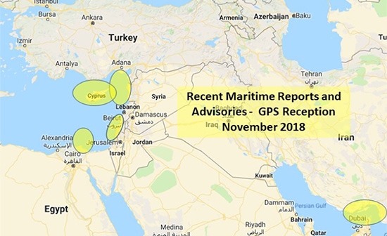
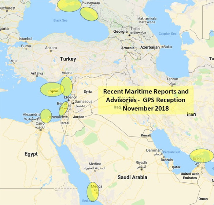
The U.S. Maritime Administration issued an expanded advisory for GPS disruptions in the Middle East. The new advisory renews and repeats warnings for the eastern Mediterranean and adds the Port of Jeddah in Saudi Arabia.
Reports have also been filed with the U..S Coast Guard Navigation Center about disruptions in Israel’s Port of Haifa and the Straits of Hormuz.
Analysis by the Resilient Navigation and Timing Foundation and the non-profit firm C4ADS has also shown on-going disruptions in Russian waters of the Black Sea. Also, GPS jamming by Russia is suspected during a recent NATO exercise.
The armed conflict in Syria has been blamed for much of the disruptions off of its shores.
GPS jamming in support of illegal fishing is suspected by some as the cause of problems off of Port Said, and disputes over mineral rights has been suggested for the disruptions seen near Cyprus.
Disruptions in the Black Sea are suspected to be security measures associated with the travel of Russian government officials.
Map: U.S. Maritime Administration Advisory 2018-014-GPS
Text of Maritime Administration Advisory
2018-014-GPS Interference-Eastern Mediterranean and Red Sea
This revised advisory cancels U.S. Maritime Advisory 2018-007.
Reference: U.S. Maritime Alerts 2018-004A, 2018-004B, 2018-008A.
Issue: Multiple instances of significant GPS interference continue to be reported by vessels and aircraft operating in the Eastern Mediterranean Sea. These reports have been concentrated near Port Said, Egypt, the Suez Canal, and in the vicinity of the Republic of Cyprus. Additional instances of similar interference were reported in October 2018 near Jeddah Port, Saudi Arabia. This interference is resulting in lost or otherwise altered GPS signals affecting bridge navigation, GPS-based timing and communications equipment.
Guidance: Exercise caution when transiting these areas. The U.S. Coast Guard Navigation Center (NAVCEN) and NATO Shipping Center websites contain information regarding effective navigation practices for vessels experiencing GPS interference. The information reaffirms safe navigation practices when experiencing possible GPS disruption, provides useful details on reporting possible GPS disruption, and is intended to generate further discussions within the maritime community about other disruption mitigation practices and procedures. This guidance also recommends taking note of critical information such as the location (latitude/longitude), date/time, and duration of the outage/disruption, and providing photographs or screen shots of equipment failures during a disruption to facilitate analysis. The NAVCEN information is available at https://go.usa.gov/xQBaU.
Contact Information: GPS disruptions or anomalies should be immediately reported to the NAVCEN at https://go.usa.gov/xQBaw or via phone at 703-313-5900, 24 hours a day. The NATO Shipping Center has requested that instances of GPS interference also be reported to them using the format on their Cyber Interference link.
Cancellation: This message will automatically expire on May 2, 2019.
When a Pennsylvania county’s 911 system suddenly went down without warning, garbled messages across the network impacted fire and police agencies’ ability to respond to emergency messages. The issue was traced to a firmware malfunction on communications equipment, related to provision of GPS timing. The firmware had not been updated for 19-1/2 years. Why should it have been? Everything was working fine — until it didn’t.
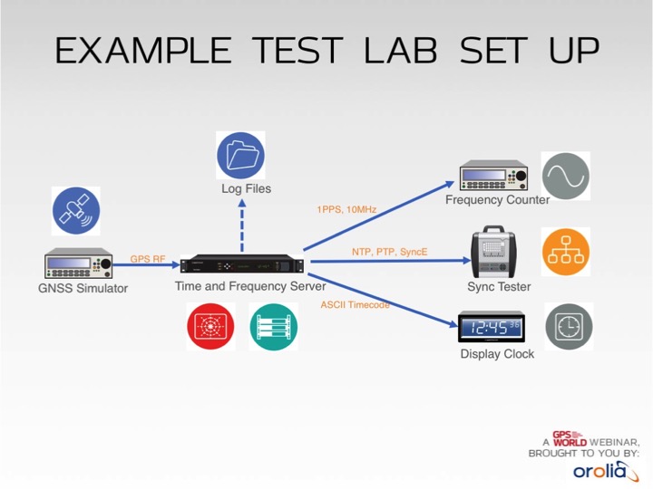
Test lab set-up. Photo: Orolia
In addition to increased jamming and spoofing threats, GPS has a “week rollover event” set to happen in April 2019. If the GPS receivers found at the heart of many critical systems do not handle this properly, any number of failures can occur.
Without GPS timing, everything slows down, has less capacity and becomes more dangerous.
This Thursday, a complimentary webinar outlines test plans for GNSS equipment used in critical timing applications, discusses the need for assured access to accurate timing across financial institutions, industrial automation, telecommunications, transportation, the power grid and elsewhere — and defines just what “assured” access means and how crucial the “assured” part is — and finally reviews some recent mishaps and near-disasters caused by interrupted or inaccurate timing.
Speaking on the 1-hour webinar are Lisa Perdue, product manager and applications engineer, Orolia; Stefania Römisch, leader, the Atomic Standards Group at the National Institute of Standards and Technology; and Dana Goward, president, Resilient Navigation and Timing Foundation.
Following each speaker’s 12- to 15-minute slide presentation, a live Q&A period with the audience will explore particular issues and concerns.
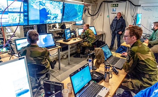
NATO conducted its largest military exercise since the Cold War in the frigid waters and icy mountains of Norway Oct. 25-Nov. 7.
During the final days of the Trident Juncture exercise, GPS signals guiding ships, aircraft, tanks, trucks and troops began to fail. Tracking screens flickered and positions were suddenly wrong from a few meters to hundreds of kilometers.
Civilian airliners, cars, trucks, cargo ships and smartphones operating in and around Norway and Finland experienced similar disruptions. Norway-based airline Wideroe told The Barents Observer that its pilots were reporting the loss of GPS signals when flying to airports in northern Norway and Finland. Airfields affected ranged from Kirkenes, on Norway’s border with Russia, to Lyngen in Troms, much further west.
Russia is the chief suspect of jamming the signals in reaction to the massive size and proximity of the military exercises. Russia also has recently conducted massive military exercises in the Baltics.
“It is possible that Russia has been the disrupting party in this,” Finland’s Prime Minster Juha Sipila told local media. “Russia is known to possess such capabilities.”
Trident Juncture involved all 29 NATO alliance members. Neutral Sweden and Finland also took part amid growing uncertainty over Russia’s ambitions in the tense region.
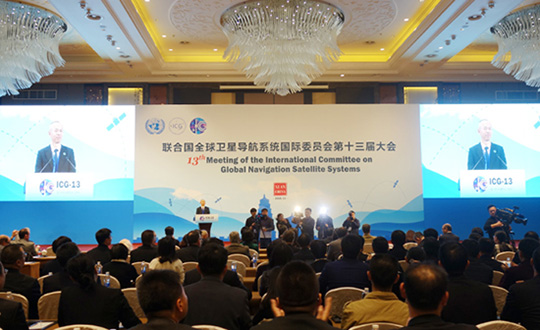
The United Nations’ International Committee on GNSS (ICG) held its 13th meeting in Xi’an, China, Nov. 4-9. Attendees included the four major GNSS: GPS (United States), GLONASS (Russia), BeiDou (China) and Galileo (Europe). Also attending were representatives from Japan, India and delegates from 16 countries and regions.
Members called for further strengthening of the interoperability and transparency of GNSS to help more countries enjoy the developments in positioning, navigation and timing, according to China Global Television Network.
On Nov. 7, China and Russia signed a cooperation agreement for BeiDou and GLONASS, stressing that the two systems begin testing service aims for countries along China’s Belt and Road.
More than 400 delegates across the world also watched the demonstration of applications based on China’s BeiDou system, which includes drones and vehicle positioning technology that could be used by self-driving cars.
The positioning system was tested on a bus with accuracy reaching millimeters, as shown in a video on this page. This technology lays the foundation for the management of urban traffic.
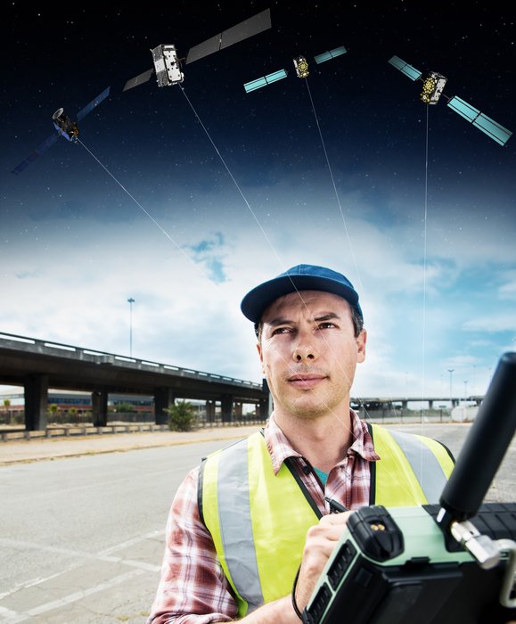
Global satellite navigation systems are continuously bathing Earth in satnav signals. As well as helping in our daily lives, these signals are also tools for cutting-edge science. A new ESA facility, based at ESA’s astronomy centre near Madrid, is championing their use for everything from Earth monitoring to fundamental physics.
A Surveyor uses a GNSS device to map urban assets with Galileo and EGNOS. (Image: ESA)
The new ESA Global Navigation Satellite Systems (GNSS) Science Support Centre is based at ESA’s European Space Astronomy Centre, ESAC, near Madrid. Run by ESA’s Galileo Science Office, the GSSC integrates IT and satnav infrastructure to deliver advanced data processing services to the scientific community.
Precisely timed to a few billionths of a second and highly stable, satnav signals can be used as a point of reference for many scientific sectors, including Earth and atmospheric sciences, astronomy, highly precise timing metrology as well as the study of relativity and other fundamental physics topics.
Current satnav infrastructure plans worldwide should see more than 120 satnav satellites in orbit in coming years. This number includes Europe’s own Galileo constellation — offering unique features such as its highly stable passive hydrogen maser atomic clocks, multiple transmission frequencies, robust modulation, wide bandwidth and onboard laser retro-reflectors, which permit exact pinpointing of the satellites’ position in space down to a few tens of centimetres.
“The potential of satnav for science has been recognised for a long time,” explains Javier Ventura-Traveset, Head of ESA’s Galileo Science Office. “The Galileo Science Office was set up in 2016 as a joint initiative between ESA’s Science and Navigation Directorates, coordinating scientific opportunities through interaction with the scientific community and the independent GNSS Science Advisory Committee.
“The opening of the new centre is the next step. It is ESA’s concrete answer to the need expressed by the scientific community for a one-stop-shop to offer researchers long-term GNSS data, products information, results of scientific experiments, plus services to enhance GNSS scientific research and collaboration.
“The future evolution of the centre will be driven by the interaction and feedback received from the scientific community, maximizing synergies with other GNSS data service providers from other institutions and research organization.”
Among the activities to be supported by the new GSSC are big data processing of large amounts of satnav data, crowdsourcing as a means of weather monitoring and a scientific assessment of satnav performance in Antarctica.
It also supports the continuing measurements of general relativity using Galileo satellites 5 and 6 and serves as a global data centre for the International GNSS Service. The long-established Navipedia website, giving technical information on satnav, is also hosted by the GSCC.
One enthusiastic early adopter is ESA’s Navigation Support Office, based at ESA’s ESOC mission control centre in Darmstadt, Germany, lending support to mission teams making use of satnav to steer satellites.
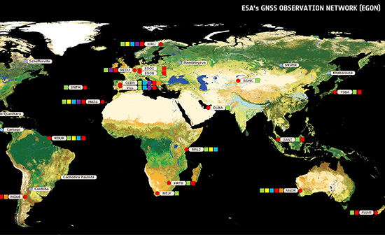
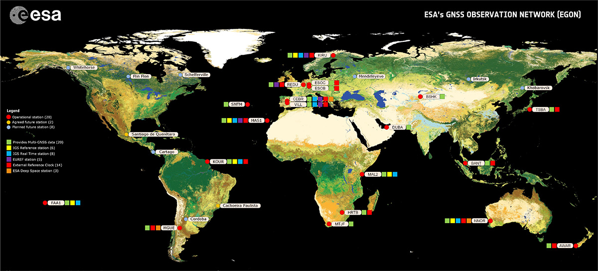
“The GSSC is a welcome addition to ESA’s activities in the science of satellite navigation,” says Werner Enderle, heading ESOC’s Navigation Support Office. “The GSSC already hosts GNSS products generated by the team at ESOC, including observations from our worldwide EGON GNSS Observation Network and precise satellite orbits generated by their state-of-the-art software. Our two teams look forward to this collaboration continuing for the benefit of ESA and the scientific community.”
The GSSC will roll out access to data, products and services over the coming months.
Agriculture equipment maker Case IH is enhancing the robustness of its RTK+ correction signal network by adding the European Galileo system to the compatible satellites with which it works.
The move will increase levels of signal reception and reliability for farmers using Case IH RTK+-guided autosteering and related technologies.
Real-time kinematic (RTK) systems typically depend on signals from the American GPS or Russian GLONASS satellite networks, both designed primarily for non-civilian use. To give European Case IH users a reliable alternative when using RTK+-guided steering systems with their sub-1.5-centimeter repeatable accuracy, Case IH AFS RTK+ now also uses Galileo.
The addition of Galileo to the global GNSS constellation helps minimize the risk of signal failure, a key driver for the integration of its signals into the Case IH AFS RTK+ signal system. European satellite network independence is a principal objective, but Case IH AFS RTK+ is also designed to be compatible with existing and planned GNSS satellites and interoperable with GPS and GLONASS.
Galileo benefits farmers by minimizing downtime from waiting for lost signals to be regained, and ensures consistent efficient use of seed, fertilizer and crop protection products through parallel passes with minimal overlap, thereby maximizing crop potential.
“The use of GNSS technology is opening up new productivity levels and opportunities in European agriculture, providing farmers with an unprecedented level of knowledge about their crops, livestock and operations while making the sector more efficient, economically competitive and environmentally sustainable,” said Maxime Rocaboy, product marketing manager, AFS technology, at Case IH.
“Enhanced RTK+ accuracy through incorporation of signals from the Galileo satellite system is a core way in which we can help Case IH tractor and combine users be innovative and competitive as they seek to help develop a sustainable agriculture to feed an ever-increasing world population in an environmentally responsible way,” Rocaboy said.
On Saturday, Nov. 10, Stanford colleagues of Professor Per Enge will host a celebration of his life. A live webcast of the event will be available here at at 1 p.m. Pacific Standard Time.
The video will be available afterwards on this site.
GPS World extends this invitation to join Per’s family and friends in celebrating the wonderful life that he led and the extraordinary impact he had on those around him. Guests at the live event will be invited to share their favorite memories.
The following statement was recently read into the minutes of the Stanford Faculty Senate:
Per K. Enge, the Vance D. and Arlene C. Coffman Professor in the School of Engineering and one of the world’s foremost experts in GPS technologies, passed away on April 22, 2018, at his home in Mountain View, California. He was 64.
Per Enge, Professor and Director, Stanford University Center for Position Navigation and Time. (Photo: Stanford University)
Per was born Oct. 29, 1953, in Bergen, Norway. He immigrated at the age of 2 to the United States with his father and mother.
He earned his B.S. in electrical engineering at the University of Massachusetts at Amherst in 1975 and his MS and PhD at the University of Illinois Urbana-Champaign in 1979 and 1983, respectively. He met his wife of 38 years, Elaine, while at UMass. His son, Nick, a Stanford graduate and now a lecturer at the University of Texas at Austin, said that despite his academic upbringing, his dad was a middling student until Elaine introduced him to the library at UMass, where she was most often found.
While pursuing his advanced degrees, Per worked in industry, where he first gained experience using radio signals for terrestrial navigation. He then took a position as assistant professor at Worcester Polytechnic Institute, where he designed a radio-navigation positioning system that today has more than 1.5 million marine and land users. He also started to work on augmenting GPS so that it could be safely used for aeronautical navigation. Due to this effort he was recruited by Stanford University for a one-year visiting professorship in 1993 that was ultimately extended to full professorship.
While at Stanford, Per became one of the FAA’s most trusted advisors on the provision of aircraft guidance. He oversaw the development of two different systems that today allow airplanes to safely determine their positions within meters regardless of the weather conditions.
Per was a member of the National Academy of Engineers, a Fellow of the Institute of Navigation, and a Fellow of the Institute of Electrical and Electronics Engineers.
Per is particularly remembered as a teacher and mentor. He designed a freshman course in electric cars and aircraft and helped launch a popular massive open online course (MOOC) for the GPS community outside Stanford. He leaves behind a strong legacy of more than 40 Ph.D. students, co-workers and colleagues who have been inspired by his genuine joy in being able to work in such an exciting field.
Per is survived by his wife, Elaine, of Mountain View, and a son, Nick, of Austin. In lieu of flowers, donations in Enge’s memory can be made to a new graduate student scholarship fund under the Stanford department of Aeronautics and Astronautics. Donations can be made at https://gps.stanford.edu/resources/giving
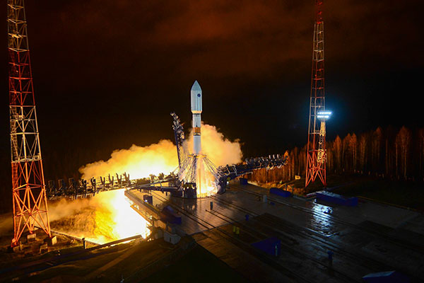
A GLONASS-M was launched Nov. 3 from the Plesetsk cosmodrome. (Photo: Russian Ministry of Defense)
A GLONASS-M satellite has safely entered its calculated orbit after a Nov. 3 launch, according to the Russian Ministry of Defense. The satellite is designated GLONASS-M 757.
The launch of the Soyuz-2.1B medium-range rocket took place Saturday, Nov. 3, at 23:17 Moscow time from the Plesetsk cosmodrome.
After separation from the third stage of the Soyuz-2 launch vehicle, the upper stage Frigate launched the navigation spacecraft into orbit.
The satellite will replenish the GLONASS constellation, which includes 27 satellites. One satellite is the newest model, GLONASS-K, and is undergoing flight tests. Another GLONASS-M is under maintenance.
A few minutes after launch, a steady telemetry connection was established and is being maintained with the satellite, which is functioning normally.
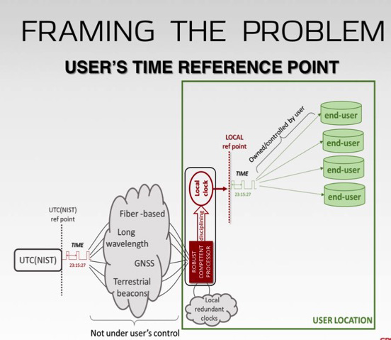
System prevented broadcast of corrupt navigation, timing data.
The GPS Operational Control System’s launch and checkout system will control launch and early orbit operations and the on-orbit checkout of all GPS III satellites. (Image: Raytheon)
Raytheon Company’s GPS Next-Generation Operational Control System, known as GPS OCX, has completed several cybersecurity vulnerability assessments that tested the system’s ability to defend against both internal and external cyber threats, the company said.
GPS OCX, based at Schriever Air Force Base in Colorado Springs, Colorado, prevented the broadcast of corrupt navigation and timing data in all tests, bolstering the program’s readiness for the GPS III launch in December, the company added.
“We’ve built a layered defense and implemented all information assurance requirements for the program into this system,” said Dave Wajsgras, president of Raytheon Intelligence, Information and Services. “We’re cognizant that the cyber threat will always change, so we’ve built GPS OCX to evolve and to make sure it’s always operating at this level of protection.”
GPS OCX is the enhanced ground control segment of a U.S. Air Force-led effort to modernize America’s GPS system. The program has implemented 100 percent of the Department of Defense’s 8500.2 Defense in Depth information assurance standards without waivers, giving it the highest level of cybersecurity protections of any DoD space system.
The first tests took place April 2-13, and were led by a contracted “blue team” that aimed to breach the system from within its information assurance boundary.
The second round of tests took place May 16-20, and were led by an Air Force “red team” of cyber-penetration testers who tried to breach the system’s IA boundary from outside. The system worked as designed, validating it is secure.
The assessments took place on the launch and checkout system, GPS OCX Block 0, which was delivered to the U.S. Air Force in 2017 as a fully cyber-secure satellite ground system.
Representatives from the global automotive industry gathered at the the Intelligent Transport Systems (ITS) World Congress in Copenhagen in September. At a “Galileo for Mobility” session, panelists showed off new products and discussed the benefits of GNSS for the deployment of multimodality, new mobility services and digital platforms by transport authorities, industries and users.
Their goal: to make safe driverless road transport a reality.
Autonomous driving with multi-GNSS
Cover image of Galileo for Mobility leaflet. (Image: GSA)
Germany’s ANavS GmbH provides position and attitude solutions with centimetre-level accuracy. Fast fixing is achieved by using three GNSS constellations and the company’s patented RTK fixing technology. The system combines multi-GNSS (GPS + GLONASS + Galileo), inertial sensors, vehicle data, visual odometry and feature mapping, as well as LiDAR and radar. Tight coupling of GNSS and all of these other systems ensure reliable positioning even in areas with limited satellite visibility.
ANavS managing director Patrick Henkel said, “Our sensor fusion framework delivers precise position and attitude information for navigation. It also generates real-time, highly accurate maps with high resolution. The platform can be used for the whole range of transport applications from road transport to maritime and drone navigation, as well as in robotics, surveying applications and of course in agriculture for precision farming.”
The system is particularly well suited to autonomous driving applications because of its high accuracy, high availability and continuity, and, with Galileo, its integrity, according to Henkel. The ANavS module is available in different versions, with one, two or three integrated GNSS receivers, depending on the level of performance required.
Sensor fusion with non-connected vehicles
Swedish truck manufacturer Scania led work on the EU-funded project, Precise and Robust Positioning for Automated Road Transports (PRoPART), demonstrating a high-availability positioning solution for connected automated driving applications. The system implements sensor fusion using information from both the on-board vehicle sensors and an off-board road infrastructure traffic sensor, accounting also for non-automated and non-connected road vehicles.
“We are benefiting from the high multipath mitigation enabled by the Galileo binary offset code, and there is a substantial improvement of reliability of the carrier phase ambiguity resolution,” said senior engineer Fredrik Hoxell. “All of this makes Galileo a really good addition to our sensor platform,” he said.
Big data contribution
Digital mapping is of course a critical resource for autonomous driving applications, and Tom Jensen of the veteran manufacturer of personal navigation devices TomTom stated “We have been compiling data from our GNSS receiver users for 10 years. We have 500 million devices currently running and today we have about 90 trillion data points!”
TomTom has dedicated itself to fusing that data for the generation of detailed maps that can be updated within minutes, for understanding traffic flow and traffic changes in near real time. “Now we want to open that up for the users,” he said. “We are meeting with public authorities, governments, decision makers who we know can use this information, for the roads, for the infrastructure, to plan their projects in the best and most intelligent way.”
Preventing terrorist attacks
The H2020-funded TransSec project coordinated by Daimler AG Trucks targets a solution to the recent rise in vehicle-based terror attacks across Europe, often employing heavy trucks to attack pedestrians.
Oihana Otaeguim, head of ITS at TransSec project partner Vicomtech, said, “We are developing and evaluating autonomous systems to detect and prevent trucks from being misused, to prevent these incidents from occurring. The trustability provided by Galileo is very remarkable. We have achieved advances in GNSS positioning, map data and map matching. On-board environment sensors and V2X communication are all combined in a local dynamic map. This can then be used for movement monitoring, critical area alarm, pre-crash object detection and for the implementation of non-defeatable emergency manoeuvres.”
The project team is also concerned with developing new and more effective methods to combat GNSS jamming and spoofing, which represent further threats to security in the context of automated driving technologies. Here, Galileo’s unique authentication feature will play an important role.
3D mapping
Japan’s Strategic Innovation Promotion Program, Automated Driving for Universal Services (SIP-adus) conducts several activities previewing the next generation of road transport systems: the human-machine interface in for autonomous and semi-autonomous driving, and the application of automated driving technologies in buses. The goal is precise stopping at bus stops with almost no space between the bus and the curb, to facilitate boarding and exiting for wheelchair users and elderly passengers.
“The project is validating the specifications and accuracy of a high-accuracy 3D mapping function,” Satoru Nakajo of the University of Tokyo said, “including data updating and distribution systems, and of the critical linkage of dynamic data delivered via road infrastructure.”
Public transport on demand. Area Metropolitana de Barcelona (AMB) will replace an existing fixed bus line with low demand with a flexible service that adapts bus routes according to the actual demand, improving the service and engaging new users without increasing public expenditure. The Galileo-based technology platform will consist of a mobile app and a system that manages requests, confirmations and cancellations, finds the best routes, and monitors distances travelled and payments.
Shared taxis. The pilot aims to alleviate Thessaloniki’s city centre congestion by reducing the number of trips from two eastern suburbs to the city. Ride sharing will be offered to commuters through 20 taxis provided by Taxiway at a flat rate.
Service aggregator. The Mobility as a Service (MaaS) app gathers mobility services available in Barcelona, Madrid and other big cities in Spain. It includes public transport, sharing services by motorbikes, bikes and cars, and bike parkings in these cities, improving accuracy and availability in urban areas, enabling a fast and smooth transition between transport modes, and offering the user a door-to-door and seamless multimodal trip experience.
Campus shuttle. The pilot will link autonomous electric vehicles to major hubs in a university or hospital campus (location to be determined).
Vehicle sharing. The Clem’ project will operate a last-mile transportation service to the community in Plateau de Saclay, an urban campus under development in the suburbs of Paris designed to welcome 85,000 students, workers and inhabitants by 2025. The pilot will include sharing a mixed fleet of 10 geolocated electric cars and 20 electric bikes.
This account drew heavily from published reports by the European GNSS Agency (GSA), available in full here.
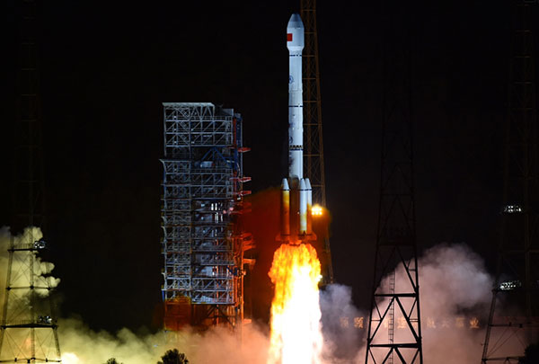
China has launched its first geostationary satellite for the BeiDou constellation, according to press reports.
The successful launch of satellite G1Q took place at 15:57 UTC on Nov. 1 from the LC2 Launch Complex of the Xichang Satellite Launch Center, Sichuan province, using a Long March-3B/G2 (Chang Zheng-3B/G2) launch vehicle.
Beidou-3G satellites are the geostationary Earth orbit (GEO) component of the third phase of the Chinese Beidou satellite navigation system. The GEO satellites will be in high orbit, about 36,000 kilometers above the Earth, following the Earth’s rotation to view the same point on Earth continuously.
In addition to navigation services, the satellite will serve as a satellite-based augmentation system (SBAS) and provide short message services (Research Data Shared Service, RDSS).
The G1Q satellite is the 17th BeiDou-3 satellite and the 41st overall BeiDou satellite. Another pair of BeiDou-3 medium Earth orbit (MEO) satellites, M17 and M18, will be launched in mid-November.
The recent BeiDou launches will expand the system to global navigation coverage.
The G1Q satellite is based on the DFH-3B bus that features a phased array antenna for navigation signals and a laser retroreflector, and also is equipped with an apogee propulsion system for final orbit insertion. The satellite has a launch mass of about 4,600 kg.