On Dec. 23, 2016, President Obama signed the National Defense Authorization Act (NDAA) for Fiscal Year 2017. The act includes policy and funding guidance for the GPS program of $847.362 million.
This total excludes $13.171 million requested for the GPS IIF program, which requires FY 2017 funding for on-orbit support and contract closeout.
Procurement of GPS III satellites is budgeted at $34 million, development of GPS III satellites is at almost $142 million and the next-generation ground control system (known as OCX) is budgeted at $393 million, which comes with certification and congressional briefing requirements. The amount includes funding for the GPS Enterprise Integrator.
The GPS Enterprise Integrator project includes the efforts associated with the government’s prime contract tasks necessary to accomplish the critical integrating function with the entire GPS user community. The Enterprise Integrator maintains the GPS architecture and system definition, controls and validates interfaces, ensures compatibility of Generation II and III systems, and develops and manages plans for execution and fielding of the GPS enterprise.
The final defense budget item is $278 million for development of new military GPS user equipment (MGUE).
Besides the NDAA, other areas that include funding for GPS and related programs are Transportation (including WAAS), to support designated civil elements of the Air Force GPS program, along with civil GPS augmentations and related activities.
In a change from prior years, the Department of Transportation (DOT) requested civil funding for the GPS program through the Office of the Secretary instead of through the FAA. Also, the request does not include funds for the Nationwide Differential GPS (NDGPS) program in FY 2017.
Below are full details of the NDAA funding provided by GPS.gov, along with links to relevantPDFs.
PROGRAM
LINE ITEM
PRESIDENT’S
BUDGET
REQUEST
HOUSE
MARK
SENATE
MARK
FINAL
Procurement: GPS III Satellites Space Procurement, Air Force, Line Item 6, “GPSIII / GPS III Space Segment” VIEW JUSTIFICATION (3.5 MB PDF)
Development: GPS III Satellites RDT&E, Air Force, Line Item No. 214 / Program Element 0305265F, “GPSIII / GPS III Space Segment” VIEW JUSTIFICATION (8 MB PDF)
Development: Next Generation Operational Control System (OCX) and GPS Enterprise Integrator RDT&E, Air Force, Line Item No. 110 / Program Element 0603423F, “Global Positioning System III — Operational Control Segment” VIEW JUSTIFICATION (8 MB PDF)
Development: Military GPS User Equipment (MGUE) RDT&E, Air Force, Line Item No. 48 / Program Element 0305164F, “NAVSTAR Global Positioning System (User Equipment) (SPACE)” VIEW JUSTIFICATION (8.5 MB PDF)
It has been a good year for all global navigation satellite systems (GNSS), as the chief executives of each system testify here. Alternative positioning, navigation and timing (PNT) also thrives. In this roundup of the latest highlights from the past year and forecasts for the future, 2017 augurs very well indeed! Let’s look at the newest alternative-PNT offerings first, followed by forecasts from the chief executive officers (CEOs) of each of the conventional GNSS.
Alternative PNT grows and expands
Two new entrants to the positioning, navigation and timing (PNT) marketplace offer key capabilities to fill in the gaps left by GNSS. A new satellite timing and location (STL) service from low-Earth orbit satellites, provided by Satelles and Orolia, gives a strong signal capable of penetrating buildings.
Satellite Time and Location (STL) Service. Pursuant to a recent announcement of new PNT solutions independent of GPS/GNSS signals, provided via the Iridium constellation, GPS World talked with Jean-Yves Courtois, CEO of Orolia. Orolia has partnered with Satelles to bring new PNT products and services to the global market, with a focus on military, and defense, government and commercial customers worldwide.
Jean-Yves Courtois, CEO of Orolia.
“We are a manufacturer and integrator of timing equipment,” Courtois said. Orolia is the parent company of GPS/GNSS product and service providers Spectracom, McMurdo and Spectratime. “This new STL service is not fully commercialized yet, but it’s operational and it can be tested. Receivers are available and can be integrated into our equipment.
“The timing signal is very accurate and close enough to GPS for most timing applications, although the positioning accuracy is lower than what GPS users are used to. It is an augmentation for timing primarily, and secondarily for positioning.
“In terms of timing accuracy, it provides on the order of tenths of microseconds in accuracy, and this covers a lot of timing applications, very familiar to us and to our customers. This is an ideal timing backup or augmentation of GPS. As number 2 worldwide in high-precision timing, we know this market and its applications very well.”
Correlator beamforming. The Locata Corporation announced a patented correlator beamforming technology to stem multipath mitigation. The new technique’s performance under rigorous testing by the U.S. Air Force Institute of Technology will be detailed in the January 2017 issue. Look for it! Here are a series of snippets as a preview of that lengthy technical article appearing in Richard Langley’s Innovation column.
“Unlike conventional or traditional beamsteering technology, the new correlator beamforming approach combines RF signals received by any number of individual antenna elements into a single switched-RF signal. This time-multiplexed signal is then downconverted and digitized by a single RF front-end. The correlator beamforming design will should offer cost savings because the resulting data stream is processed using a single correlator channel per beam. This markedly reduces the complexity when compared to the traditional beamsteering methodology.
“The correlator beamforming technique performs antenna array signal processing to form beams as part of a receiver’s correlation process. The complete explanation of this technology can quickly get complex, even for the seasoned RF engineer. To describe this process more simply, we will assume noiseless signals and no multipath (except as noted), as well as equal noise figures for all front-end processing chains. To further simplify our explanation, modulation on the carrier and switching losses will be ignored.”
“To evaluate the performance of correlator beamforming as fairly as possible compared to traditional beamsteering and single-element processing, AFIT set up its data collection such that all three approaches could be implemented in a software receiver. Additionally, a seven-element Naval Air Systems Command GPS Antenna System 1 (GAS-1) antenna was used for this experiment. The antenna was mounted on a 51-inch (130-centimeter) diameter rolled-edge ground plane provided to the ANT Center by the MITRE Corporation.”
“The testing focused on demonstrating an easily modified GNSS receiver to potentially deliver a low-cost solution for mitigating multipath — specifically targeting short delay and carrier multipath. The results presented here show that the multipath rejection performance nearly equals that of a traditional beamsteering GNSS receiver. Applications that can significantly benefit from this technology include stationary GNSS monitoring installations such as those used in satellite-based and ground-based augmentation systems and GNSS receivers for autonomous vehicles and UAVs in high multipath areas such as urban canyons.”
GPS III ready, steady
Col. Steve Whitney, Director, U.S. Air Force GPS Directorate
“The [GPS III] program is working to solve several technical challenges as we progress to completion,” Col. Steve Whitney, director of the U.S. Air Force GPS Directorate, wrote in GPS World’s December issue. “SV-01 testing uncovered electro-magnetic interference between a payload component and a hosted payload. Testing also uncovered electron impact issues on the L-band antenna elements. In partnership with Lockheed Martin, the program developed corrective action and design mitigations for both of these issues and is implementing these steps within our production flow for all the SVs.”
“In the coming year, SV-02, the second GPS III satellite, will also be progressing towards completing production. Currently, all of the SV-02 sub-assemblies have been received by Lockheed Martin and are being integrated into the spacecraft. The next major step in the production flow for SV-02 will be to mate it with its propulsion core.
“Recently, we completed negotiations with Lockheed Martin to extend the production line with purchases of SV-09 and SV-10. These satellites will be technically equivalent to SV-01 through SV-08. This $395 million purchase of two satellites marks a significant affordability milestone for the procurement of GPS III satellites.
“Looking ahead, we are analyzing how to acquire satellites beyond SV-10. We are executing a phased strategy which starts first with determining the viability of a GPS III production design existing beyond the current contractor. We awarded an initial phase of contracts to the Boeing Company, Lockheed Martin Space Systems Company, and Northrop Grumman Aerospace Systems in May 2016 to provide a feasibility assessment of the readiness of their satellites designs. In this phase, the contractors will provide a GPS III production design, manufacturing plans and a navigation payload brassboard test report, along with manufacturing/production processes and facilities maturity.”
Galileo coming on strong
Director of the Galileo Programme Paul Verhoef of the European Commission wrote in that same issue of the magazine, “The production of the satellites continues to maintain a steady rhythm, with a production line stretching from suppliers across Europe to OHB and SSTL and then to ESA’s ESTEC Test Centre in the Netherlands for acceptance testing, based on a wide range of simulated space tests.”
Paul Verhoef, director of the Galileo Programme and Navigation-related Activities, European Space Agency.
“The acceptance of the next satellites to launch is scheduled for this year’s end,” continued Verhoef. “Along with the two more Ariane 5 launches to come — one in the second half of 2017 and another in 2018 — the current plan is to commission further launch services as well as additional satellites in order to have Galileo fully operational by 2020. For these launches, Galileo may be the first customer of the new Ariane-6 launch vehicle.
“2017 will see the upgrade of various elements of the Galileo Ground Segment to reinforce its robustness, including updated releases to the Galileo Control Segment overseeing the satellites and the Galileo Mission Segment, overseeing the navigation signals. A new release of elements of the Galileo Security Facility, for security monitoring of the system, as well as the secure Public Regulated Service, will be deployed at the two Galileo Security Monitoring Centres.
“The Galileo Ground Segment will gain a sixth tracking telemetry and control facility, for monitoring the satellite platforms in Papeete, Tahiti, and additional processing chains for increased redundancy will be deployed across the Uplink Stations in Kourou, Reunion and Noumea used to update the navigation message information. Similar redundant chains will be finalized for all 15 current Galileo Sensor Stations, which perform continuous collection of Galileo signals to identify the tiniest clock error or satellite drift.”
EGNOS. “Along with the progress of Galileo, contracts are planned to cater for the further development of the ESA-designed European Geostationary Navigation Overlay Service, Europe’s first navigation system. EGNOS was certified for safety-of-life aviation use in 2011, and is managed by the European Commission through a contract with operator the European Satellite Services Provider, based in France. ESA will support the technical evolution of EGNOS version 3, intended as multi-constellation in nature, again through the Horizon 2020 framework.”
GLONASS looks forward to a new signal: CDMA!
Sergey Karutin, GLONASS Chief Designer, wrote “On the threshold of the first GLONASS-K2 launch, new GLONASS reference documents were published in October 2016, describing the family of code-division multiple-access (CDMA) radionavigation signals. The draft GLONASS Open Service Performance Standard has been developed. The GLONASS User Information Support System continues to evolve.”
From left: Sergey Karutin, GLONASS designer general; Nicolay Testoedov, director general, SC Information Satellite Systems; and Andrey Tulin, director general, SC Russian Space Systems.
“The system transmitting CDMA navigation signals is referred to in four interrelated interface control documents containing general information on signals and the detailed description of signal structures and digital message data. The new signals make it possible to include 63 satellites in the constellation, not only in circular medium-Earth orbit but also on geostationary and high-Earth orbits.
“The transition to the flexible string-type structure of the message data produces 2-second periodicity of integrity information delivery to users. The increased number of digits occupied by the ephemeris and clock parameters contributes to a better orbit and clock broadcast accuracy. The ephemeris broadcast precision improves from 0.4 to 0.001 meters. Time-stamp length in CDMA signal has increased to 30 bits, compared to 12 bits of frequency-division multiple-access signals.”
BeiDou approaches full regional services
Li Wang
“In 2017, three to four launches of BeiDou satellites will occur,” wrote Li Wang, Director of the International Cooperation Center in China’s Satellite Navigation Office. “BDS will provide basic services to the countries along the Belt and Road region by 2018, and possess global service capability by 2020.”
“BDS will keep improving its nationwide reference station network and steadily enhance its service performance. The dense reference stations for the nationwide frame network will be constructed by 2018, providing meter and decimeter level real-time location services for users in China, even centimeter level service in some areas.
“BDS will carry out the design, validation and construction of SBAS in accordance with international civil aviation standards. The first GEO satellite of BDSBAS will be launched in around 2018. The satellite-based augmentation services covering China and surrounding regions will be provided from 2020, to provide CAT-I services to civil aviation users.
“China will promote construction of a national comprehensive positioning, navigation and timing (PNT) system based on BDS, and strive to establish such a national PNT system with a united benchmark, no-gap coverage, security and effectiveness by 2030, as well as to upgrade capabilities to provide time and space information.”
Two important new signals — or rather, one signal and one group of signals — became available for military users worldwide last week. Satelles made an exciting announcement of what amounts to a new dimension in satnav: a whole new constellation in low-Earth orbit, bringing global coverage and most critically, a signal strength hitherto unknown to GNSS users. The satellite time and location (STL) has primary application in the timing realm, which is vital in many applications.
Higher in the sky, Europe’s GNSS satellites constituting the Galileo system officially began offering their services, and the multiple frequencies available here mean robustness, greater availability in obstructed environments, and — some say, though this is controversial — greater positioning accuracy, largely through more precise timing onboard.
Meanwhile, GPS World seeks a new defense editor for this column, and adopting the concept of “promoting from within,” now turns to its readership for interested parties to volunteer.
A New SatNav That’s Not GNSS
A strategic alliance announced on Dec. 15 between companies Orolia and Satelles includes will provide positioning, navigation and timing (PNT) solutions provided by the Iridium satellite constellation, independent of GPS/GNSS signals. The companies intend to provide PNT solutions to military, defense, government and commercial customers worldwide. Their new satellite timing and location (STL) service can supply much-needed robustness to GPS-dependent operations.
Orolia, the parent of GNSS-active companies Spectracomm, McMurdo, and Spectratime, has extensive experience in the defense realm. The company says it is #1 worldwide in the manufacture of military beacons outside the U.S. with a 60% market share, and #2 within the U.S., and that it is the first-ranked provider of Medium-altitude Earth Orbit Search and Rescue system (MEOSAR) worldwide. In partnership with Satelles, it will provide the STL service independent from traditional GPS and other GNSS satellite signals. STL is reported to be less susceptible to vulnerabilities such as spoofing, interference and jamming that are associated with GPS/GNSS — and the stronger signal penetrates buildings where GPS/GNSS cannot reach.
Iridium satellite, courtesy Iridium.
Based on the low-Earth orbit (LEO) Iridium satellite constellation, STL signals are up to 1,000 times stronger than GPS/GNSS; this signal strength, due in part to the constellation’s closer proximity to users, helps to prevent jamming and enables signal reach into buildings and other difficult locations. STL’s additional cryptographic security also enhances performance, productivity and security.
Projected key applications and use cases include energy/utility grids, enterprise data networks including financial systems, maritime/aviation navigation, fleet/asset tracking management, search and rescue and data center management.
“The timing signal is very accurate and close enough to GPS for most timing applications, although the positioning accuracy is lower than what GPS users are used to,” said Orolia CTO Jean-Yves Courtois. “It is an augmentation for timing primarily, and secondarily for positioning.”
“In terms of timing accuracy, it provides on the order of tenths of microseconds in accuracy, and this covers a lot of timing applications, very familiar to us and to our customers. This is an ideal timing backup or augmentation of GPS. As number 2 worldwide in high-precision timing, we know this market and its applications very well.”
“In positioning it’s closer to fifty meters or more. Much better for fixed objects than for mobile objects. The more mobile, the faster the vehicle, then the lower the positioning accuracy. It’s not directly usable for GPS applications that require a few meters accuracy, but it can be associated with inertial navigation for much better results.”
“The signal is encrypted, so you have to subscribe to a service to receive a key, allowing access to the signal. Applications are developing based on equipment that will be STL-enabled. For the user it will be transparent. The user will have a different antenna.”
“We are also active in tracking and emergency location devices, where this is also of interest. It has some authentication capability, to guarantee that the person who accesses the signal is in the location that he pretends to be.”
Galileo, live at last!
Also on Dec. 15, the European Commission issued the Galileo Initial Services Declaration. The Declaration of Initial Services means that the Galileo satellites and ground infrastructure are now operationally ready. These signals will be highly accurate but not available all the time, since the constellation is not yet complete and users cannot always count on four satellites being visible at one time at all points on the Earth.
Galileo has a significant role to play in military operations. It adds multiple frequencies to the GNSS palette, important for resistance to jamming. It adds satellites, and will add more in the new future, very important for signal availability. And its Public Regulated Service (PRS) is specifically designed with special features for security, defense and military operations.
I attended a GNSS Symposium recently in Australia where an academic expert repeated the oft-made assertion that Galileo is the only GNSS that is civil-designed and civil-controlled. At which point an industry expert leaned over, grabbed the microphone and growled “Yeah, right.”
No matter how you look at it, Galileo add important benefits to GPS for the suitably equipped warfighter.
This Newsletter Enters a New Era
Beginning in January 2017, this Defense PNT newsletter will combine with our GeoIntelligence Insider e-newsletter to offer broad coverage of both hardware and software matters, driven by GPS/GNSS, and enhancing the capabilities of security, defense, military and other government forces. Readers of both newsletters will receive the new combined edition as a matter of course.
Many readers will know of the recent passing of Don Jewell, the longtime editor of Defense PNT. We must soldier on, and GPS World hereby extends an invitation to readers of this newsletter — many of whom, we know, are military experts in your own right — who may wish to volunteer to fill Don’s position. Please write to [email protected] to request details, and please provide a brief outline of your background and experience.
At a Dec. 15 ceremony in Brussels titled “Galileo Goes Live,” two high officials of the European Commission issued the Galileo Initial Services Declaration.
The Declaration of Initial Services means that the Galileo satellites and ground infrastructure are now operationally ready. These signals will be highly accurate but not available all the time, since the constellation is not yet complete and users cannot always count on four satellites being visible at one time at all points on the Earth.
Simultaneously, the European GNSS Agency (GSA) awarded the Galileo Service Operator (GSOp) contract, with a value of up to 1.5 billion euros, to Spaceopal, a joint venture between Telespazio and the German Space Agency (DLR).
At the moment, the Galileo constellation consists of 18 satellites in orbit. However, two of these are in an orbit not totally useful for positioning and navigation. Four more, launched in November, may or may not have completed their on-orbit testing (a series of notice advisory to Galileo users or NAGUs appeared today relating to the flag status of each satellite, see details at the end of this story) but have not yet been integrated to the operational constellation. This is foreseen to take place in spring 2017.
During the initial phase, the first Galileo signals will be used in combination with other satellite navigation systems, like GPS. In coming years, new satellites will be launched to enlarge the constellation, gradually improving Galileo availability worldwide. The constellation is expected to be complete by 2020 when Galileo will reach full operational capacity (FOC) of 30 satellites: 24 satellites plus six orbital spares, intended to prevent any interruption in service.
“The announcement of Initial Services is the recognition that the effort, time and money invested by ESA and the Commission has succeeded, that the work of our engineers and other staff has paid off, that European industry can be proud of having delivered this fantastic system,” stated ESA Director general Jan Woerner.
Paul Verhoef, ESA’s Director of the Galileo Programme and Navigation-related Activities, added, “Today’s announcement marks the transition from a test system to one that is operational. We are proud to be a partner in the Galileo programme.
“Still, much work remains to be done. The entire constellation needs to be deployed, the ground infrastructure needs to be completed and the overall system needs to be tested and verified.
“In addition, together with the Commission we have started work on the second generation, and this is likely to be a long but rewarding adventure.”
Galileo Initial Services are managed by the European GNSS Agency (GSA). The overall Galileo programme is run by the European Commission, which has handed over the responsibility for the deployment of the system and technical support to operational tasks to the European Space Agency (ESA).
Operator Contract
The GSOp contract runs for 10 years and covers operation and maintenance of the Galileo satellite system and its committed performance level: in particular, the operations and control of the system, the logistics and maintenance of the systems and infrastructure as well as the user support services.
“With its emphasis on service performance, this contract will shape the future of Galileo. We look forward to building a strong partnership with Spaceopal as Galileo moves towards full operational capability under the responsibility of the GSA from January 2017,” said GSA Executive Director Carlo des Dorides.
Specifically, under GSA management the contract awarded to Spaceopal includes:
Secure operations of Galileo from two mission control centres (GCC), located in Germany and Italy, and the European GNSS Service Centre (GSC) for user support services in Spain;
Management of the Galileo Data Distribution Network (GDDN);
Integrated logistics support and maintenance for the entire space and ground infrastructure;
Monitoring of the system performance;
Support the completion of the Galileo infrastructure and associated launches.
Spaceopal has served as the contractor for Galileo operations since 2010 under the Galileo Full Operational Capability (FOC) Operations Framework Contract.
Products and Services
The first Galileo smartphone by Spanish company BQ is now available on the market, and other manufacturers are expected to follow suit. Application developers can now test their ideas on the basis of a real signal.
With this Declaration, Galileo will start to deliver, in conjunction with GPS, the following three types services free of charge. Their availability will improve as more satellites are launched.
The Open Service is a free mass-market service for users with enabled chipsets in, for instance, smartphones and car navigation systems. Fully interoperable with GPS, combined coverage will deliver more accurate and reliable positioning for users.
Galileo’s Public Regulated Service is an encrypted, robust service for government-authorised users such as civil protection, fire brigades and the police.
The Search and Rescue Service is Europe’s contribution to the long-running Cospas–Sarsat international emergency beacon location. The time between someone locating a distress beacon when lost at sea or in the wilderness will be reduced from up to three hours to just 10 minutes, with its location determined to within 5 km, rather than the previous 10 km.
Maroš Šefčovič, à gauche, et Elżbieta Bieńkowska.
Accolades and Encouragements
At the “Galileo Goes Live” ceremony in Brussels, EC Vice-President Maroš Šefčovič, responsible for the Energy Union, said: “Geo-localisation is at the heart of the ongoing digital revolution with new services that transform our daily lives. Galileo will increase geo-location precision ten-fold and enable the next generation of location-based technologies; such as autonomous cars, connected devices, or smart city services. Today I call on European entrepreneurs and say: imagine what you can do with Galileo — don’t wait, innovate!”
Commissioner Elżbieta Bieńkowska, responsible for Internal Market, Industry, Entrepreneurship and SMEs, said: “Galileo offering initial services is a major achievement for Europe and a first delivery of our recent Space Strategy. This is the result of a concerted effort to design and build the most accurate satellite navigation system in the world. It demonstrates the technological excellence of Europe, its know-how and its commitment to delivering space-based services and applications. No single European country could have done it alone.”
Canadian GNSS manufacturer NovAtel, a long-time participant in Europe’s space navigation programs, sent its congratulations to ESA, the EC and GSA upon the launch of Galileo Initial Services. President and CEO Michael Ritter stated, “Today’s declaration validates the confidence of the program’s supporters that Europe would join the world’s operators of global navigation satellite systems.”
NovAtel‘s receivers, antennas and certified ground-reference station receivers have supported Galileo signals in anticipation of the complete constellation. NovAtel now broadcasts Galileo Precise Point Positioning (PPP) corrections through its TerraStar correction services, and states that its OEM customers are already benefiting from the enhanced reliability, availability and accuracy the Galileo constellation adds to the GNSS.
Graham Purves, president and CEO of Veripos, a provider of global precise point positioning (PPP) correction services to the marine oil and gas industry, stated, “As a European company, we are particularly proud and excited about the opportunities the Galileo services create for our customers. The reliability and safety enhancements made possible through these new services allow Veripos to continue to expand the capabilities of our cutting edge safety critical positioning solutions.”
Veripos’s worldwide network of 80 reference stations already supports Galileo, enabling Veripos to deliver Galileo PPP corrections over satellite through products such as its commercially available Apex5 correction service. Veripos also offers Galileo support on its LD5 and LD56 GNSS receivers and Quantum software for industry leading high precision marine positioning solutions.
Advisory Updates
USABINIT NAGUs were issued for 11 satellites: 0101, 0102, 0103, 0203, 0204, 0205, 0206, 0208, 0209, 0210, and 0211. USABINIT, or Initially Usable, notifies users that a satellite is set healthy for the first time. 0104 had a power problem and is operating on E1 only. 0201 and 0202 were launched into lower orbits. 0207 and 0212-0214 are still undergoing commissioning and drifting to their designated orbital slots.
A strategic alliance announced on Dec. 15 between Orolia and Satelles includes product development and go-to-market activities of positioning, navigation and timing (PNT) solutions provided by the Iridium satellite constellation, independent of GPS/GNSS signals. The companies intend to provide PNT solutions to military, defense, government and commercial customers worldwide.
Orolia, the parent of GNSS-active companies Spectracom and Spectratime, among others, announced that it has formed a strategic alliance, including an equity investment with Satelles Inc. to develop, market and sell PNT solutions based on Satelles’ satellite time and location (STL) signal technology. STL is a unique space-based PNT technology that provides location and timing data independent from traditional GPS and other GNSS satellite signals. By using STL, Orolia’s Spectracom and McMurdo solutions will, according to the company, be less susceptible to vulnerabilities such as spoofing, interference and jamming that are associated with GPS/GNSS.
Iridium satellite, courtesy Iridium.
Based on the low-Earth orbit (LEO) Iridium satellite constellation, STL signals are up to 1,000 times stronger than GPS/GNSS; this signal strength, due in part to the constellation’s closer proximity to users, helps to prevent jamming and enables signal reach into buildings and other difficult locations. STL’s additional cryptographic security also ensures performance, productivity and security.
Projected key applications and use cases include energy/utility grids, enterprise data networks including financial systems, maritime/aviation navigation, fleet/asset tracking management, search and rescue and data center management. Further details on planned projects and products of the Orolia-Satelles partnership will be posted to this site in a follow-up story in coming days.
Many highly sensitive military, defense, government and commercial applications and operations require accurate and reliable PNT data. Today, these applications rely on signals from GPS/GNSS satellites. There are instances, however, where GPS/GNSS signal strength and security are not sufficient and prone to signal disruption. For these cases, the companies jointly state, STL can be used as a secure signal of opportunity to complement GPS/GNSS, making the applications more accurate and secure and less prone to interference and attack.
“In today’s increasingly dynamic and mobile world, there is a growing need for precise and robust positioning, navigation and timing information especially in business-critical, high risk and life-saving operations,” said Jean-Yves Courtois, Orolia CEO. “By augmenting Orolia’s market-leading GPS/GNSS-based solutions with Satelles’ STL technology, we will have the industry’s first essentially fail-safe, resilient PNT solution. This breakthrough offering will be ideal for mission critical applications in which the smallest of discrepancies in PNT data accuracy, availability and stability can result in a network outage, a system crash or a loss of life.”
“Satelles’ pioneering role in STL technology is a perfect fit with Orolia’s proven Resilient PNT strategy,” said Michael O’Connor, Satelles CEO. “We look forward to working together to introduce new products and solutions that will provide our customers with the utmost confidence that their positioning, navigation and timing data is accurate, secure and accessible.”
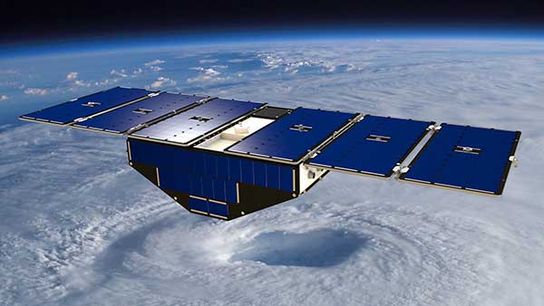
Surrey Satellite Technology’s Space GNSS Receiver Remote Sensing Instrument (SGR-ReSI) is the primary payload onboard NASA’s CYGNSS constellation, launched today, Dec. 15, from Cape Canaveral Air Force Station in Florida.
The Cyclone Global Navigation Satellite System (CYGNSS) mission is part of the NASA Earth System Science Pathfinder Program that aims to improve extreme weather prediction by studying how tropical cyclones form.
Artist’s concept of one of the eight CYGNSS satellites in orbit. (Image: NASA/University of Michigan)
The CYGNSS space segment consists of a constellation of eight micro satellites, each carrying the Surrey SGR-ReSI as the observatory payload in the form of a delay Doppler mapping instrument (DDMI). Making use of reflected global positioning signals, the DDMI collects ocean surface roughness data using a technique called GNSS reflectometry, providing CYGNSS with a new method for looking inside hurricanes. Wind speed will be estimated from this reflectometry data.
“At the end of last year, we delivered the SGR-ReSI flight models, low-noise amplifiers, and antennas to Southwest Research Institute for final integration into the CYGNSS observatories — marking a significant hardware shipment out of our Englewood, Colorado, manufacturing facility,” said Clare Martin, vice president of programs at Surrey Satellite Technology U.S.. “All of us at Surrey are proud that our instrument is playing an integral role in this mission, and we will watch with great interest as the satellites are put to work.”
The CYGNSS team is made up of the University of Michigan Department of Climate and Space Sciences and Engineering, Southwest Research Institute (SwRI), Surrey Satellite Technology and Sierra Nevada Corporation.
Surrey Satellite Technology demonstrated the concept of GNSS reflectometry for the first time on its UK-DMC mission launched in 2003, and subsequently developed the SGR-ReSI, which is currently flying on Surrey’s TechDemoSat-1 mission.
CYGNSS is NASA’s first Earth science small satellite constellation, designed to help improve forecasting hurricane intensity, hurricane tracks and storm surges.
CYGNSS will measure previously unknown details crucial to accurately understanding the formation and intensity of tropical cyclones and hurricanes.
“This is a first-of-its-kind mission,” said Thomas Zurbuchen, associate administrator for NASA’s Science Mission Directorate at the agency’s headquarters in Washington. “As a constellation of eight spacecraft, CYGNSS will do what a single craft can’t in terms of measuring surface wind speeds inside hurricanes and tropical cyclones at high time-resolution, to improve our ability to understand and predict how these deadly storms develop.”
The CYGNSS mission is expected to lead to more accurate weather forecasts of wind speeds and storm surges — the walls of water that do the most damage when hurricanes make landfall.
Using the same GPS technology that allows drivers to navigate streets, CYGNSS will use a constellation of eight micro satellite observatories to measure the surface roughness of the world’s oceans. Mission scientists will use the data collected to calculate surface wind speeds, providing a better picture of a storm’s strength and intensity.
Unlike existing operational weather satellites, CYGNSS can penetrate the heavy rain of a hurricane’s eyewall to gather data about a storm’s intense inner core. The eyewall is the thick ring of thunderstorm clouds and rain that surrounds the calm eye of a hurricane. The inner core region acts like the engine of the storm by extracting energy from the warm surface water via evaporation into the atmosphere.
The latent heat contained in the water vapor is then released into the atmosphere by condensation and precipitation. The intense rain in eyewalls blocks the view of the inner core by conventional satellites, however, preventing scientists from gathering much information about this key region of a developing hurricane.
“Today, we can’t see what’s happening under the rain,” said Chris Ruf, professor in the University of Michigan’s Department of Climate and Space Sciences and Engineering and principal investigator for the CYGNSS mission. “We can measure the wind outside of the storm cell with present systems. But there’s a gap in our knowledge of cyclone processes in the critical eyewall region of the storm — a gap that will be filled by the CYGNSS data. The models try to predict what is happening under the rain, but they are much less accurate without continuous experimental validation.”
The CYGNSS small satellite observatories will continuously monitor surface winds over the oceans across Earth’s tropical hurricane-belt latitudes. Each satellite is capable of capturing four wind measurements per second, adding as many as 32 wind measurements per second for the entire constellation.
CYGNSS is the first complete orbital mission competitively selected by NASA’s Earth Venture program. Earth Venture focuses on low-cost, rapidly developed, science-driven missions to enhance our understanding of the current state of Earth and its complex, dynamic system and enable continual improvement in the prediction of future changes.
The U.S. Air Force approved Lockheed Martin’s design to upgrade the current GPS satellite ground control system with new capabilities that will enable it to operate more powerful and accurate GPS III satellites.
The successful Critical Design Review (CDR) for the Contingency Operations (COps) contract, completed on Nov. 17, gives Lockheed Martin a green light to proceed with software development and systems engineering to modify the existing GPS ground control system, called the Architecture Evolution Plan (AEP) Operational Control Segment.
SV 01 in testing at Lockheed Martin’s Denver facility. (Photo: LMCO)
The AEP is currently maintained by Lockheed Martin and controls the 31 GPS IIR, IIR-M and IIF satellites in orbit today.
The COps modifications will allow the AEP to support the more powerful, next generation GPS Block III satellites, enabling them to perform their positioning, navigation and timing mission, once they are launched. COps is envisioned as a temporary gap filler prior to the entire GPS constellation’s transition to operations onto the next generation Operational Control System (OCX) Block 1, currently in development.
“The GPS constellation is a valuable asset to our warfighters, our nation and the world. This risk-reduction effort ensures the Air Force has the ability to maintain the constellation at full strength,” said Mark Stewart, vice president of Lockheed Martin’s Navigation Systems mission area. “We are here to support the Air Force and the GPS III program any way we can.”
The Air Force awarded the $96 million COps services and supplies contract to Lockheed Martin on February 3. The government approved the company’s proposed ground system modification during a Preliminary Design Review on May 11.
On Oct. 15, under a separate contract, Lockheed Martin completed the Commercial Off-the-Shelf (COTS) Upgrade #2 (CUP2) project — part of a multi-year plan to refresh the AEP’s technology and enhance the system’s ability to protect data and infrastructure from internal and external cyber threats, as well as improve its overall sustainability and operability. CUP2 is now fully operational and managing the current GPS constellation.
Lockheed Martin has a long history of supporting ground systems, providing operations, sustainment and logistics support for nearly 60 Department of Defense satellites, including GPS, often allowing them to double their on-orbit operational design life.
Lockheed Martin also is under contract to develop and build the Air Force’s first ten GPS III satellites, which will deliver three times better accuracy, provide up to eight times improved anti-jamming capabilities and extend spacecraft life to 15 years, 25 percent longer than the newest GPS satellites on-orbit today.
GPS III’s new L1C civil signal also will make it the first GPS satellite to be interoperable with other international global navigation satellite systems.
Russian Space Systems has released draft versions of the GLONASS interface control documents (ICD) for the future code division multiple access (CDMA) signals in the L1, L2 and L3 bands.
Parameters of the subsystem interfaces between the spacecraft and GLONASS navigation consumer equipment are determined by the GLONASS Interface Control Document.
The ICD is only available in Russian, but an English translation is expected soon.
PDF files of the documents for each signal can be downloaded here:
Q: What significant new developments in positioning, navigation or timing can we anticipate in 2017?
Dan Conway, Executive VP, Guidance & Stabilization, KVH Industries
A: With increasing focus on robust and resilient positioning, navigation and timing (PNT), the industry must respond with improved access to accurate and trusted position and timing, particularly for the warfighter. For military vehicles, this translates to a requirement for improved navigation systems that will provide commanders and onboard vehicle electronic systems with resilient PNT in contested environments. Secure and more robust navigation systems must now, more than ever, assure position and timing regardless of access to satellites.
Jeff Martin, VP of Business Development & Sales, Spirent Federal
A: Global navigation satellite systems have continually evolved, and 2017 should be no exception. With the scheduled launch of GPS III satellites, the world will see two new signals: M-code from a directional antenna and L1C (new civil signal). The European Galileo system may become operational. Russia is not expected to launch the new GLONASS K-2 satellites in 2017, but it’s not far off. Developers, integrators and users will have lots of options in 2017!
A: With approximately 65 percent of mass-market receiver chipsets already capable of multi-constellation tracking — and with this figure set to rise significantly in the near future — the demand for cost-effective but highly capable consumer goods with GNSS capabilities is clearly growing at an exponential rate. The forthcoming civilian signals offer huge opportunity to many sectors, but also present a challenge in the test and validation of new products, which will require highly capable and flexible simulation equipment.
A: Next year will bring huge strides in autonomous navigation. Multi-band high-precision GNSS will be a key enabler for robotics applications. Customers are demanding navigation solutions that are accurate, fast, robust and affordable. Multi-band enables convergence times measured in seconds, not minutes. Rapid time to first fix and reacquiring fix quickly after passing under obstructions will be essential for autonomous driving applications. Low-cost L1/L2 RTK GNSS will help bring these autonomous robotic applications to life.
I write at an especially exciting moment for the Galileo satellite navigation system, as two flagship European programmes combine for the very first time.
Mid-November will see the very first Galileo launch using an Ariane 5 launcher from Europe’s Spaceport in French Guiana, in place of the Soyuz that has served the constellation up until now. Four instead of two Galileo satellites will be launched at a time: The number of satellites girding the globe will rise at a single stroke from 14 to 18.
Meanwhile, the European Union is set to declare Galileo operational for initial services at the end of this year, bringing the system to the point where it can finally start serving users.
Paul Verhoef, director of the Galileo Programme and Navigation-related Activities, European Space Agency.
When Galileo Meets Ariane
November’s launch has been years in the making, employing a specially customized variant of Europe’s heavy-lift workhorse rocket called the Ariane 5 ES (Evolution Storable) Galileo. It has more powerful lower stages and a reignitable upper stage, first used in 2008 to supply the low-Earth orbiting International Space Station.
This new launcher design, adapted beginning in 2012 for Galileo, will carry a lower mass payload — four fully-fuelled 738-kg Galileo satellites plus their supporting dispenser — but must haul it to the much higher altitude of medium-Earth orbit, 23,522 km.
This precisely targeted orbit actually lies 300 km above the Galileo constellation’s final working altitude, leaving Ariane’s upper stage in a stable graveyard orbit, while the quartet of satellites maneuver themselves down to their final height.
Satellites. The satellites continue unchanged from those preceding them: Galileo full operational-capability (FOC) satellites with platforms from OHB in Germany and navigation payloads from Surrey Satellite Technology Ltd in the UK.
All 14 FOC satellites follow the first four in-orbit validation (IOV) satellites launched in 2011 and 2012; these four validated overall Galileo system design with the first wholly European navigation fix in March 2013.
Carrier. The four-satellite dispenser, the interface between the satellites and its launcher, is a wholly new design by Airbus Defence and Space. Its first role is to hold the satellites safely in position during their orbital flight and then to gently release them in separate directions. Its structure has been specially tuned to prevent harmful oscillations being triggered by the vibration and noise of launch. Its design was validated using complex finite-element modeling software, followed by practical testing of the dispenser together with dummy satellites.
Launcher. Ariane’s interstage Vehicle Equipment Bay, hosting the rocket’s avionic brain, underwent a redesign to reduce mass. Engineers also had to take into account this Ariane ES version’s flight time, much longer than any of its predecessors, more than four hours in all.
This involved a reworking of the launcher’s electronics and thermal subsystems, to ensure it maintains an optimal operational environment throughout a ballistic coast phase of more than three hours, between two firings of its EPS storable propellant upper stage. Two further Ariane 5 SE Galileo flights are planned to follow, one each for the remaining orbital planes.
Members of the joint Galileo Launch and Early Operations Phase (LEOP) team at work in CNES Toulouse. A joint team from ESA and France’s CNES space agency oversee Galileo LEOPs – the initial switching on and checking and configuration of satellite systems. LEOP is run from either ESOC or CNES Toulouse, on an alternating basis. (Photo: ESA)
Ground Control. This launch will mark the first time that ESA carries out launch and early operations (LEOP) for four satellites simultaneously. Usually, simply shepherding a spacecraft through the first critical days in orbit is a demanding enough task. A combined team from ESA and France’s CNES space agency based in Toulouse will make contact, establish control, and then see the four satellites through their initial critical activities. Within the combined team, each position is paired with a counterpart from the other agency to provide three mixed shifts around the clock for these first crucial days. This same team has conducted all Galileo early operations to date alternately from Toulouse or ESA’s ESOC control center in Germany.
The work starts with an initial check of on-board health and attitude, progressing to ensure each satellite’s pair of 1 x 5-meter solar wings are deployed and tracking the Sun, and then to point their antennas back towards Earth. Next comes a series of thruster firings to set the satellites onto a drift course into their final orbit, at which point they can be handed over to the Galileo Control Centre in Oberpfaffenhofen, Germany, for routine operations, and to ESA’s Redu Centre in Belgium to commence a few months of detailed payload testing.
Galileo at Your Service
Around the same time as this key launch, GSAT-210 and GSAT-211, the two previous satellites launched in May of this year, will have completed their in-orbit testing, allowing them to be formally certified as operational members of the constellation. The four new satellites should follow them into operational status by mid-2017. However, the Galileo system will reach initial operational status without these latest six satellites. The European Commission on behalf of the European Union expects to declare the system operational and ready to offer initial services before the end of this year.
This will mark a major milestone in the programme, awaited by many citizens in Europe and around the globe. Everyone with a Galileo-enabled receiver will be able to benefit from improved positioning, supplementing the already operational GPS constellation. ESA and the European GNSS Agency (GSA) have been working with European manufacturers of mass-market satnav chips and receivers to ensure that their products are Galileo-ready, offering detailed laboratory testing to close the loop between Galileo and industry.
Transition. In parallel to the declaration of initial services, there will also be an institutional change, as the GSA takes up its role overseeing the exploitation of Galileo. At the start of 2017, the formal handover of Galileo infrastructure will be initiated, targeted to conclude by the middle of the year. This mission includes not only the Galileo satellites in space but also the far-flung ground stations located on every continent, essential to the continued high-performance operations of the Galileo system. It also includes the two European Galileo control centers, with the signals overseen from Fucino in Italy and the platforms monitored from Oberpfaffenhofen, plus the communication infrastructure connecting them all together.
In the history of ESA, a research and development agency, this kind of handover to an operational body is not unprecedented; the agency handed Europe’s Meteosat weather satellites over to the newly created Eumetsat organisation, and pioneering telecommunication satellites came under the control of Eutelsat and Inmarsat. However, the Galileo ground segment will hold a special place in ESA history as one of the most complicated developments it has ever undertaken, serving to maintain the signals from the satellites to a nanosecond-scale of performance.
ESA will maintain its role of system design authority and system procurement agent, continuing to support system exploitation as it prepares for the follow-on Galileo Second Generation (G2G) design, supported through the EU’s Horizon 2020 programme. For example, the current contract of Galileo’s ground support operator will end next year, so ESA is supporting the GSA in initiating the contractual process to select a replacement operator. This contract covers all the interaction between the ground segment elements which are vital to the system as a whole. Maintaining continuity of service with transition to the new operator will certainly present a big challenge to the entire team, but one we are confident of meeting.
Upgrade. In parallel, 2017 will see the upgrade of various elements of the Galileo Ground Segment to reinforce its robustness, including updated releases to the Galileo Control Segment overseeing the satellites and the Galileo Mission Segment, overseeing the navigation signals. A new release of elements of the Galileo Security Facility, for security monitoring of the system, as well as the secure Public Regulated Service, will be deployed at the two Galileo Security Monitoring Centres.
The Galileo Ground Segment will gain a sixth tracking telemetry and control facility, for monitoring the satellite platforms in Papeete, Tahiti, and additional processing chains for increased redundancy will be deployed across the Uplink Stations in Kourou, Reunion and Noumea used to update the navigation message information. Similar redundant chains will be finalized for all 15 current Galileo Sensor Stations, which perform continuous collection of Galileo signals to identify the tiniest clock error or satellite drift.
New Satellites. The production of the satellites themselves continues to maintain a steady rhythm, with a production line stretching from suppliers across Europe to OHB and SSTL and then to ESA’s ESTEC Test Centre in the Netherlands for acceptance testing, based on a wide range of simulated space tests. The acceptance of the next satellites to launch is scheduled for this year’s end. Along with the two more Ariane 5 launches to come — one in the second half of 2017 and another in 2018 — the current plan is to commission further launch services as well as additional satellites in order to have Galileo fully operational by 2020. For these launches, Galileo may be the first customer of the new Ariane-6 launch vehicle.
EGNOS. Along with the progress of Galileo, contracts are planned to cater for the further development of the ESA-designed European Geostationary Navigation Overlay Service, Europe’s first navigation system. EGNOS was certified for safety-of-life aviation use in 2011, and is managed by the European Commission through a contract with operator the European Satellite Services Provider, based in France. ESA will support the technical evolution of EGNOS version 3, intended as multi-constellation in nature, again through the Horizon 2020 framework.
Finally, ESA is also addressing the challenges of satellite navigation beyond Galileo through the creation of the Navigation Innovation and Support Programme (NAVISP), which will be proposed to Europe’s space ministers for approval in December. Applying ESA’s expertise from Galileo and EGNOS, the optional NAVISP will undertake research work in support of ESA Member States’ national objectives and industrial competitiveness in the upstream and downstream navigation sector, including the fusion of satellite navigation with various disruptive technologies and complementary positioning techniques.
Galileo satellites 13 and 14 have begun transmitting navigation signals as fully operational members of the constellation.
The pair were launched from Europe’s Spaceport in French Guiana on May 24.
After launch and maneuvers to reach their final orbital altitude, their navigation and search-and-rescue payloads were methodically switched on and checked out. Their performance was assessed in relation to the rest of Galileo system.
Europe’s 13th and 14th Galileo satellites being encapsulated inside their launcher fairing. (Photo: ESA)
This lengthy test phase saw the satellites being run from the second Galileo Control Centre in Oberpfaffenhofen, Germany, while their payloads’ output was assessed from the European Space Agency’s (ESA’s) Redu centre in Belgium, equipped for the tests with specialized antennas for receiving and uplinking signals.
The test campaign measured the accuracy and stability of the satellites’ atomic clocks — essential for the timing precision to within a billionth of a second as the basis of satellite navigation — as well as assessing the quality of the navigation signals.
Oberpfaffenhofen and Redu were linked for the entire campaign, allowing the team to compare Galileo signals with satellite telemetry in near-real time, according to ESA.
These two satellites were visible in the sky above Redu for a limited time each day, ranging from three to nine hours, so tests were scheduled accordingly.
Now that in-orbit testing is completed, the satellites are transmitting working navigation signals and are ready to relay any Cospas–Sarsat distress calls to emergency services.
The next four satellites, launched together on Nov. 17, are beginning the same in-orbit testing activity, with the aim of joining the network next spring.
From left: Sergey Karutin, GLONASS designer general; Nicolay Testoedov, director general, SC Information Satellite Systems; and Andrey Tulin, director general, SC Russian Space Systems.
In October 2017 we will celebrate the 35th anniversary of the first GLONASS satellite launch. Since 1982, the capabilities provided by GLONASS satellites have multiplied and the system’s ground infrastructure has expanded beyond the Russian Federation.
Growing demand for satellite navigation services and increasing user requirements call for continuing modernization, which is only possible if advanced, technically complex solutions are employed, thorough efforts on design and in-orbit validation are made, and continuing dialogue with users is maintained to promptly react to their needs.
The stable operation of the third generation GLONASS-M satellites, the core of the today’s constellation, means more satellites are working beyond their design lifetime. In 2016, two single-satellite launches occurred, in February and May. Seven more satellites of this type remain in ground storage.
The reliability of on-orbit satellites forces us to develop new ground storage technologies since some satellites were manufactured more than three years ago, while the need for their launch may not arise until 2018. Therefore in the next two years the constellation will be sustained with this type of satellite.
The performance of the on-board atomic frequency standards (AFS) carried by the latest GLONASS-M satellites is considerably better than that of those carried by the first GLONASS-M satellites (see Figure 1). Their relative one-day stability has improved from 10-13 to 2.4× 10⁻¹⁴, contributing to smaller signal-in-space range errors (SISREs).
FIGURE 1. Estimation of the Allan Variation versus GLONASS System Timescale.
In February 2016, flight testing of the fourth generation GLONASS-K satellite was completed. It carries not only a cesium atomic-beam tube but a rubidium AFS for the first time in GLONASS history. The relative daily stability of this rubidium AFS is 4×10-14. As a result the SISRE for this satellite is about 1 meter.
We are also proud of the success of the passive hydrogen maser (PHM), which we have been building for almost 7 years (Figure 2). Multiyear ground tests displayed its excellent reliability and one-day stability of 5×10-15. It is expected to contribute to 0.3-meter SISRE. The PHM for flight tests measures 360×180×630 millimeters and weighs 25 kilos. Its power consumption is 54 watts. The PHM will be validated onboard the GLONASS-K2 satellite set for launch in 2018.
FIGURE 2. Passive hydrogen maser.
Passive hydrogen maser plot.
User Needs. On the threshold of the first GLONASS-K2 launch, new GLONASS reference documents were published in October 2016, describing the family of code-division multiple-access (CDMA) radionavigation signals. The draft GLONASS Open Service Performance Standard has been developed. The GLONASS User Information Support System continues to evolve.
The system transmitting CDMA navigation signals is referred to in four interrelated interface control documents containing general information on signals and the detailed description of signal structures and digital message data. The new signals make it possible to include 63 satellites in the constellation, not only in circular medium-Earth orbit but also on geostationary and high-Earth orbits.
The transition to the flexible string-type structure of the message data produces 2-second periodicity of integrity information delivery to users. The increased number of digits occupied by the ephemeris and clock parameters contributes to a better orbit and clock broadcast accuracy. The ephemeris broadcast precision improves from 0.4 to 0.001 meters. Time-stamp length in CDMA signal has increased to 30 bits, compared to 12 bits of frequency-division multiple-access signals.
The GLONASS Open Service Performance Standard, being drafted according to recommendations of the International Committee on Global Satellite Navigation Systems (ICG), is harmonized with the Performance Standard Template elaborated by the Working Group on Systems, Signals and Services of ICG with the active involvement of the Russian Federation.
As a result, it is also harmonized with the GPS, Galileo and BeiDou performance documents — in addition to international parameters like the horizontal and vertical availability, user positioning error (average and worst over Earth’s surface) and UTC broadcast error. The Draft Standard also includes:
PDOP availability (PDOP availability for the worst point on the Earth’s Surface, global average);
User Equivalent Range Error for the worst point of a satellite visibility cone (95%);
UTC(SU)-GLONASS Time offset broadcast error (global average 95%);
21 healthy satellites availability;
Per-slot availability;
24 healthy satellites availability;
Continuity (probability that a healthy satellite becomes unhealthy without notification 48 hours in advance);
Major failure probability (SIS URE of >75 meters).
GLONASS User Information Support infrastructure development is a complex program that covers establishing User Information Centers to raise awareness of all categories of users of the capabilities GLONASS provides and its guaranteed performance through www.glonass-iac.ru in Russian, English and Chinese languages.
The network of GLONASS-based navigation and information service providers is being developed. Services include satellite navigation activities, from emergency response to control of autonomous unmanned vehicles.